DEMOGRAPHIC AND SETTLEMENT HISTORY OF CHECHNYA AND INGUSHETIA.
A Regional Literature Review of Population and Settlement (10000BC - 1900AD).
Abstract
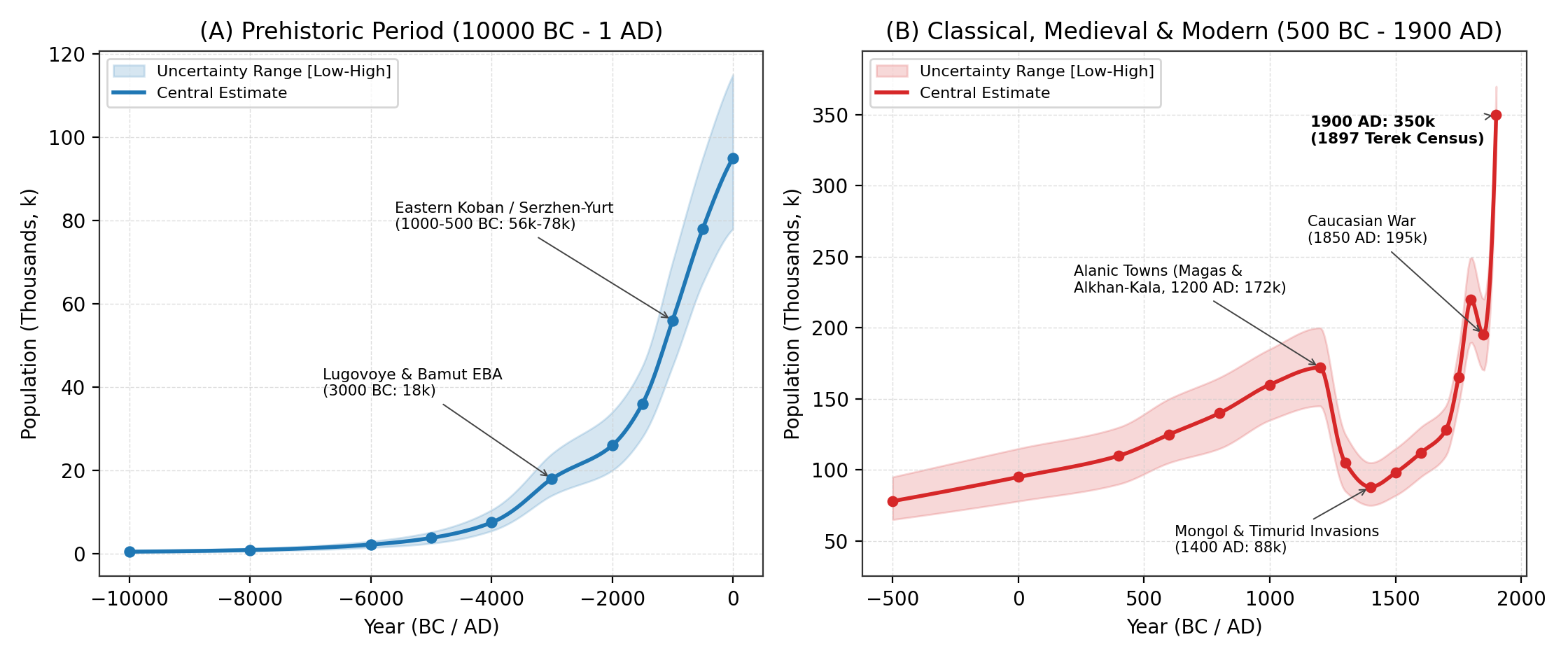
This paper reviews the archaeological, bioarchaeological, architectural, and archival literature to reconstruct the population and settlement history of Chechnya and Ingushetia (20,8k km² combined: 17,2k km² Chechen Republic and 3,6k km² Republic of Ingushetia) from 10000BC to 1900AD. Rather than extrapolating from raw site counts, our synthesis examines long-term settlement change across three main elevation zones: (1) Early Holocene canyon foragers and Early Bronze Age Kura-Araxes-Maykop contact settlements (Lugovoye / Muzhichi, Bamut, Serzhen-Yurt I), reaching ~18,0k by 3000BC [1][2][3]; (2) the Late Bronze and Early Iron Age Eastern Variant of the Koban Culture (1200-400BC, represented by Serzhen-Yurt, Zandak, and Nesterovskiy), when fortified hillforts and bronze metallurgy supported 56,0k (1000BC) to 78,0k (500BC) inhabitants [4][5][6][7]; (3) the Early and High Medieval Alanic urban period (400-1238AD), when fortified town (gorodishche) networks along the Sunzha, Assa, Argun, and Terek (Alkhan-Kala [60 ha], the Nazran-Ekazhevo / Magas cluster of >30 fortified settlements, and Germenchuk) raised regional population to 172,0k (145,0k-200,0k) around 1200AD, with 75% living on the fertile piedmont plains [8][9][10][11][12]; and (4) the upland displacement (1238-1400AD) caused by the 1239-1240 Mongol siege of Magas and Timur's 1395 destruction of Simsir, which halved regional population to 88,0k (75,0k-105,0k) and concentrated 77% of survivors in the fortified stone tower and collective crypt villages of the Armkhi, Assa, and Argun gorges (Egikal, Erzi, Targim, Vovnushki, Tsoy-Pede, Khoy) [13][14][15][16], before the 16th-18th-century Vainakh return to the Sunzha-Argun plains lifted population to 128,0k by 1700AD and 220,0k by 1800AD [17][18][19][20]. Following severe wartime mortality during the Caucasian War (1818-1859; 195,0k in 1850AD) and the 1865 muhajir deportation of ~22,0k Chechens and Orstkhoy (Karabulaks) to the Ottoman Empire, natural growth, Cossack settlement, the 1893 Grozny oil boom, and the 1897 First All-Russian Imperial Census document a rise to 350,0k (330,0k-370,0k) by 1900AD [20][21][22][23].
Background
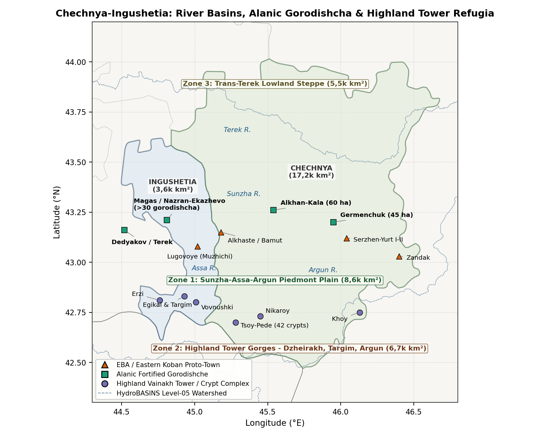
Occupying the north-central and northeastern slopes of the Greater Caucasus between the upper Terek-Assa watershed and the Andi ridge, the historical Vainakh territory (20,8k km²) is divided into three parallel east-west belts (Figure 1 and Table 1):
- The Sunzha-Assa-Argun Piedmont Plain and Foothill Valleys (Zone 1, 8,6k km², 100-500 m): Watered by the Sunzha (Сунжа) and its right-bank tributaries (Assa, Fortanga, Gehi, Martan, Argun, Dzhalka, Gums, Aksay), this fertile piedmont belt served as the main agricultural zone of the central-eastern Caucasus during the Early Bronze Age (Lugovoye, Serzhen-Yurt I), the Eastern Koban era (Serzhen-Yurt, Alkhaste, Bamut), the Alanic kingdom (Alkhan-Kala, Nazran-Ekazhevo / Magas), and the 16th-19th-century Vainakh resettlement of the plains (Chechen-Aul, Aldy, Shali, Germenchuk, Gekhi, Urus-Martan, Nazran, Grozny) [1][5][9][15].
- The Highland Limestone and Slate Tower Gorges (Zone 2, 6,7k km², 500-4 493 m): Rising to Mount Tebulosmta (4 493 m) and Mount Shan (4 451 m), the deep canyons of the Armkhi (Dzheirakh), upper Assa (Targim basin), Fortanga (Orstkhoy / Akki), upper Argun (Malkhista, Maysta, Terloy, Chanti, Shubuty, Mulkoi), Sharo-Argun (Sharoy, Cheberloy), and wooded Ichkeria (Nokhch-Mokhk) formed natural mountain refuges [13][24][25]. Following the 13th-14th-century Mongol and Timurid campaigns across the Sunzha plain, these gorges saw extensive construction of mortar-bound residential stone towers (gala), pyramidal combat towers (vov), and above-ground collective vaulted crypts (maigash / kash) [10][13][26].
- The Trans-Terek Lowland Steppe (Zone 3, 5,5k km², -10 to 150 m): North of the Terek river (Naurskaya, Shelkovskaya, Kargalinskaya steppes), mobile pastoralists (Scythians, Sarmatians, Savirs/Khazars, Kipchaks, Golden Horde Tatars, and Nogais) alternated with fortified river settlements along the Terek bluff and, from the 16th to 19th centuries, the Greben and Terek Cossack stanitsas [8][17][20].
Methodology
Regional Subdivisions
To track population movements between the fertile Sunzha-Assa-Argun piedmont and the mountain tower gorges, we divide Chechnya and Ingushetia (20,8k km²) into three elevation zones (Table 1):
| Sub-Regional Zone | Elevation | Area (km2) | River Basins | Key Archaeological and Historical Centres |
|---|---|---|---|---|
| 1. Sunzha-Assa-Argun Piedmont Plain | 100 to 500 m | 8,6k | Sunzha, lower Assa, Fortanga, Martan, lower Argun, Aksay and Terek valley | Lugovoye, Serzhen-Yurt, Alkhan-Kala, Magas (Nazran-Ekazhevo), Shali, Grozny |
| 2. Highland Tower Gorges and Wooded Ichkeria | 500 to 4 493 m | 6,7k | Dzheirakh (Armkhi), Targim (upper Assa), Argun, Sharo-Argun and Hulhulau | Egikal, Erzi, Targim, Vovnushki, Tsoy-Pede, Khoy, Nikaroy, Sharoy, Vedeno |
| 3. Trans-Terek Lowland Steppe | -10 to 150 m | 5,5k | Left-bank Terek valley and Shelkovskaya-Naurskaya semi-arid steppe | Trans-Terek kurgans, Golden Horde river crossings, Greben/Terek Cossack stanitsas |
| Total Chechnya and Ingushetia | -10 to 4 493 m | 20,8k | Terek-Sunzha-Argun drainage basin | Major prehistoric, Alanic, and Vainakh tower complexes |
Estimation Methods
Regional population estimates
- Eastern Koban Hillfort and Cemetery Estimates (1200-400BC): Excavations by V. I. Kozenkova at Serzhen-Yurt I-II (~8-10 ha craft settlement with cobbled streets, >60 timber-and-wattle dwellings, and bronze-foundry workshops) and its adjacent cemetery (>120 excavated flat graves) alongside Zandak, Bamut, Nesterovskiy, and Lugovoye establish a density of 40-65 persons/ha for Eastern Koban hillforts (400-650 residents per major settlement) [4][5][6][7].
- Alanic Fortified Town (Gorodishche) Area Estimates (400-1238AD): For the Early and High Medieval Alanic fortification network mapped by V. B. Vinogradov, Kh. M. Mamaev, D. Yu. Chakhkiev, and V. Yu. Malashev [12][27], population is estimated from intramural citadel area (80-120 persons/ha) plus open agricultural posad settlements (25-40 persons/ha) across the Alkhan-Kala urban centre (60 ha fortified core + >150 ha suburbs; 8,0k-15,0k inhabitants) and the Nazran-Ekazhevo / Ali-Yurt (Magas) settlement cluster (>30 fortified towns spanning ~100 km²; 15,0k-25,0k inhabitants) [9][10][11][28].
- Highland Stone Tower (Gala) and Collective Crypt (Maigash / Kash) Counts (1300-1700AD): In Zone 2, over 300 fortified stone tower villages (aul-kreposti) containing >2 000 residential towers (gala, 2-3 storeys, one nuclear or stem family of 5,5-6,5 persons per tower) and >250 pyramidal combat towers (vov, 4-6 storeys, 22-31 m high) are cross-checked against skeletal MNI counts inside multi-tiered collective stone crypts (Tsoy-Pede [42 crypts], Egikal, Erzi, Khoy, Vaserkel, where each lineage crypt accumulated 60-150 burials across 6-8 generations) [10][13][16][24][25].
- 16th-18th-Century Russian Posolskiye and Fortress Registers (1550-1800AD): Diplomatic dispatches compiled by E. N. Kusheva [17], N. G. Volkova [18][29], and Ya. Z. and Sh. B. Akhmadov [30][31][32] record village counts (kabaki / auly), household totals (dvory), and military levies across Okotskaya zemlya (Aukh), Michkizskaya zemlya (Ichkeria), Shubutskaya zemlya (Shatoy / Argun), Kalkanskaya / Erokanskaya zemlya (Ingush gorges), and the resettled Sunzha-Argun plains [15][19][33].
- Imperial Military Statistics, the 1886 Family Lists, and the 1897 Census (1860-1900AD): Late 19th-century estimates are anchored to A. P. Berger's (1859) village enumerations [34], the 1867-1890 statistical tables of Terek Oblast analysed by Z. Kh. Ibragimova [21] and V. M. Kabuzan [20], the 1886 family lists (posemeynye spiski), and Volume 68 (Terskaya Oblast') of the 1897 First All-Russian Imperial Census across Grozny, Vedeno, Nazran/Sunzha, and left-bank Terek Cossack districts [22][23].
Historical Overview
Mesolithic to Early and Middle Bronze Ages: Kezenoy-Am, Lugovoye, and Bamut (10000 - 1200BC)
During the Early Holocene (10000-5000BC), Mesolithic and Neolithic hunter-gatherers occupied high-mountain lake basins (Kezenoy-Am, 1 870 m) and limestone cave overhangs in the Argun, Sharoy, and Assa gorges, increasing gradually from 0,5k (10000BC) to 3,8k (5000BC) [2][3]. During the 4th and 3rd millennia BC (Eneolithic and Early Bronze Age, 4000-2000BC), the Sunzha-Assa-Argun piedmont became an active contact zone where the Northeastern Caucasian Kura-Araxes culture met the Maykop-Novosvobodnaya kurgan tradition [1][2]:
- Lugovoye (Muzhichi, Assa Valley) and Serzhen-Yurt I: Excavated by R. M. Munchaev (1952-1957), the Lugovoye settlement and cemetery in the Assa gorge of Ingushetia (157 excavated burials) and the lower layer of Serzhen-Yurt I (Shali district, Chechnya) revealed wattle-and-daub houses with sunken circular hearths, horn-lugged Kura-Araxes burnished pottery, stone shaft-hole axes, and arsenical bronze daggers and spiral temple rings [1][2].
- The Bamut Kurgan Field (Бамутские курганы): On the Fortanga-Assa piedmont exit, Munchaev excavated over 50 Early and Middle Bronze Age kurgans combining Maykop-Novosvobodnaya metalwork with Kura-Araxes domestic pottery [2]. By 3000BC, piedmont farming villages and transhumant herders numbered 18,0k (14,0k-24,0k), rising during the Middle Bronze Age North Caucasian (Ginchi and Pre-Koban) cultures (Galaity, Achkhoy-Martan, Harachoy) to 26,0k (2000BC) and 36,0k (1500BC) [3].
Late Bronze and Early Iron Ages: The Eastern Koban Hillforts (1200 - 400BC)
Between the 12th and 5th centuries BC, Chechnya and Ingushetia formed the core territory of the Eastern Variant of the Koban Culture (Восточный вариант кобанской культуры), studied in detail by V. I. Kozenkova and M. Kh. Bagaev [3][4][5][6][7][35]:
- Serzhen-Yurt I-II Settlement: Situated on two naturally defended river terraces above the Bass river (Shali district), Serzhen-Yurt functioned from the 11th to the 6th century BC as a large craft and farming centre (~8-10 ha). Excavations uncovered cobble-paved main streets (4 m wide), rows of timber-framed clay dwellings (20-45 m²), bronze-smelting furnaces with clay tuyères and stone casting moulds for Koban shaft-hole axes, zoomorphic terracotta figurines, and grain storage pits [5][6][36].
- Piedmont and Gorge Cemeteries (Nesterovskiy, Alkhaste, Lugovoye, Zandak, Sharoy): Over 80 Eastern Koban settlements and cemeteries line the Sunzha-Assa-Argun foothills and mountain gorges (the Zandak stone-cist cemetery in Nozhay-Yurt containing >60 graves; Nesterovskiy and Alkhaste in Ingushetia yielding bimetallic iron-and-bronze daggers and early Scythian akinakes weapons from the 7th-5th centuries BC) [3][4]. Supported by mixed millet-barley cultivation and mountain sheep-cattle husbandry (with 5,9% terraced land in mountainous Ingushetia [37]), total regional population rose from 56,0k (45,0k-70,0k) in 1000BC to 78,0k (65,0k-95,0k) in 500BC.
Sarmatian and Alanic Towns: Magas and Alkhan-Kala (400BC - 1238AD)
During the Sarmatian period (300BC - 300AD, 95,0k at 1AD) and the Early Alanic period (400-800AD, 110,0k in 400AD -> 140,0k in 800AD), a dense network of earthen-rampart and moated fortified towns (gorodishcha) developed along the Sunzha, Assa, Argun, and Terek rivers [8][11][12][27][38][39]:
- Alkhan-Kala (Алхан-Калинское городище, 18 km west of Grozny on the Sunzha): Protected by triple concentric horseshoe ramparts and deep moats backing onto a steep Sunzha river cliff, Alkhan-Kala enclosed a 60-hectare urban core surrounded by >150 ha of craft suburbs and a large catacomb cemetery (>2 500 kurgan and flat catacombs spanning the 2nd to 12th centuries AD) [8][12][38][39]. Serving as the main administrative and trading centre of the central Sunzha basin, Alkhan-Kala housed 8,0k-15,0k inhabitants prior to its destruction in 1238-1240.
- The Nazran-Ekazhevo-Yandare (Magas / Магас) Settlement Cluster: In the upper Sunzha-Assa-Kambileyevka interfluve of lowland Ingushetia, surveys by D. Yu. Chakhkiev, N. D. Kodzoev, and U. B. Gadiev documented a cluster of over 30 fortified gorodishcha and >60 satellite villages spaced 0,5-2,0 km apart within a ~100 km² core (Hatrig-Yurt, Ekazhevo I-IV, Nazran, Ali-Yurt, Surkhakhi, Yandare, Gazi-Yurt) [9][10][40][41][42]. Identified by regional archaeologists with the Alanic capital Magas (Ma'as, described by al-Mas'udi in 943AD and besieged by the Mongol princes Möngke, Güyük, Kadan, and Büri from winter 1239 to early 1240 according to Juwayni and Rashid al-Din), this urban cluster housed 15,0k-25,0k inhabitants [9][10].
- Eastern Sunzha and Argun Fortified Towns (Germenchuk, Shali, Aldy, Goryacheistochnenskoye): Further east, fortified towns (15-45 ha each) controlled the Argun-Sunzha confluence and Terek crossings [12][43]. At its pre-Mongol high point around 1200AD, Chechnya and Ingushetia supported 172,0k (145,0k-200,0k) inhabitants (8,27 persons/km²), with 75% (129,0k) living on the Sunzha-Assa-Argun piedmont plain (Zone 1).
Mongol and Timurid Invasions and the Highland Stone Tower Villages (1238 - 1500AD)
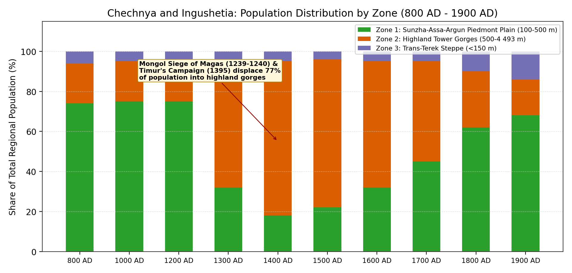
Between 1238 and 1395AD, the lowland settlement network of Chechnya and Ingushetia was destroyed by two waves of invasion (Figure 2B and Figure 3):
- The Mongol Conquest (1238-1240) and Golden Horde Rule: Following the storming and levelling of Magas (1239-1240), Alkhan-Kala, and Dedyakov (1277-1278 joint Mongol-Rus' siege recorded in the Russian chronicles), the fertile Sunzha and Terek plains were turned into winter pastures (kochev'ya) of the Golden Horde khans (Batu, Berke, Uzbek), where Ibn Battuta visited Uzbek Khan's camp at Bish-Dag in 1334 [10][15]. Total regional population fell by nearly 40% to 105,0k (85,0k-125,0k) by 1300AD.
- Timur's Campaign against Simsir and the Mountain Gorges (1395-1396): After defeating Tokhtamysh on the Terek river in April 1395, Timur invaded the Vainakh principality of Simsir (Симсир) (ruled by Gayur Khan across Ichkeria and the Sunzha-Argun foothills) and marched into the highland gorges (Aukhar, Buri-Burd, Kuli, Taus). As recorded by Sharaf al-Din Yazdi and Nizam al-Din Shami, Timur's troops demolished stone fortresses, burned terraced fields, and killed defenders across the mountains [14][15]. By 1400AD, regional population dropped to a late-medieval low of 88,0k (75,0k-105,0k), and its geographical distribution shifted sharply upward: 77% (67,8k) of all inhabitants were now concentrated in the mountain gorges of Zone 2, while the Sunzha plain (Zone 1) held only 18% (15,8k).
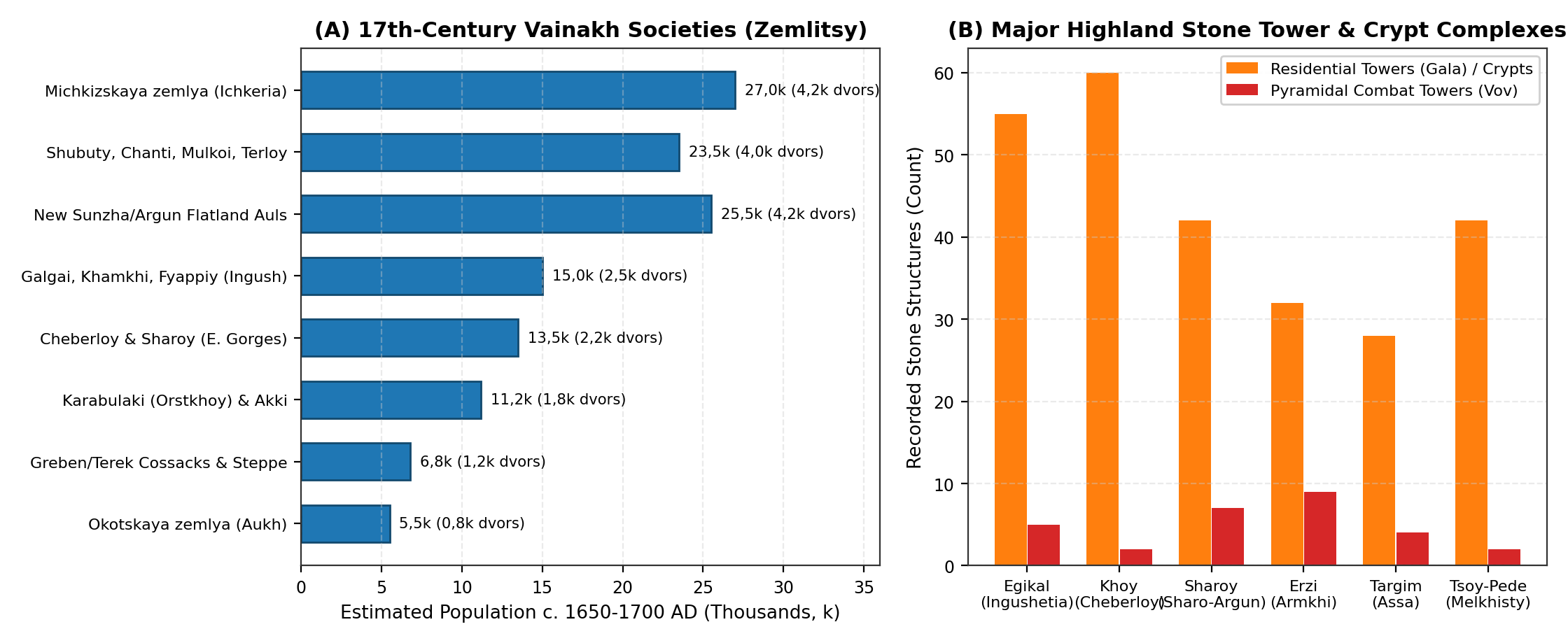
Refugee movement into the limestone canyons of the Armkhi (Dzheirakh), upper Assa (Targim basin), Fortanga, and upper Argun (Malkhista, Maysta, Terloy, Chanti, Cheberloy) spurred the construction of Vainakh stone tower complexes across the 14th to 17th centuries, documented by V. I. Markovin and D. Yu. Chakhkiev (Figure 4B) [10][13][24][25]:
- Ingush Gorge Complexes (Egikal, Erzi, Targim, Khamkhi, Vovnushki, Puy): In the Targim basin and Armkhi gorge, Egikal (Эгикал) alone contained over 50 mortar-bound residential stone towers (gala), 5 intact pyramidal combat towers (vov, up to 27 m high with machicolations and slate-slab roofs), 6 subterranean and 106 above-ground collective stone crypts (kash), and 3 sanctuary shrines (Tkhaba-Yerdy, Albi-Yerdy) [10][13][26].
- Chechen Argun and Cheberloy Complexes (Tsoy-Pede, Khoy, Nikaroy, Sharoy, Vaserkel, Pakoch): At the confluence of the Chanty-Argun and Meshi-Khi rivers in Malkhista, the cemetery of Tsoy-Pede (Цой-Педе) preserved 42 gabled stone collective crypts guarded by two defensive barrier walls and combat towers (>3 000 cumulative burials across the 14th-17th centuries) [13][16]. In Cheberloy (Kezenoy-Am basin), the cliff settlement of Khoy (Хой) and the 7-tower complex of Sharoy (Шарой) anchored dense terraced mountain communities [24][44].
Return to the Plains: Sixteenth and Seventeenth-Century Vainakh Societies (1500 - 1700AD)
Following the breakup of the Golden Horde and the founding of the Russian fortress of Terki (Терский город, 1567 / 1588) on the lower Terek, land scarcity on the mountain terraces of Zone 2 prompted a gradual Vainakh return to the forested foothills (Chernye gory) and the Sunzha-Argun-Aksay plains (1550-1700AD) [17][18][19][33][45].
Drawing on Russian Posolskiy Prikaz ambassadorial journals (Semen Zvenigorodskiy 1589, Fedor Takmakov 1604, Khodotetskiy 1638, Terki Voivode Books 1614-1690) analysed by E. N. Kusheva [17], N. G. Volkova [18][29], and Ya. Z. Akhmadov [15][19][32][33], total population across Chechnya and Ingushetia grew from 98,0k (1500AD) to 112,0k (1600AD) and 128,0k (110,0k-145,0k) by 1700AD (Figure 4A and Table 2):
- Okotskaya Zemlya (Окоцкая земля / Aukh): Located along the Aksay, Yamansu, and Aktash foothills (Staryy Okokh, Shovkhal-Berd), ruled by the mirzas Shikh-Murza (killed 1596) and Batay-Murza, who fielded 500-1 000 horsemen and footmen in Russian service (~850 households; 5,5k inhabitants, plus the Okotskaya Sloboda at Terki) [17][19][45].
- Michkizskaya Zemlya (Мичкизская земля / Wooded Ichkeria - Nokhch-Mokhk): Comprising 36 large villages along the Michik, Gums, Hulhulau, and Aksay rivers (Benoy, Tsontaroy, Gordali, Alleroy, Zandak, Vedeno); Posolskiy Prikaz reports (1619-1647) credit the Michkizy with 3 000-5 000 fighting men (3,8k-4,6k households; 24,0k-30,0k inhabitants) [17][19].
- Upper and Middle Argun Societies (Shubuty / Shatoy, Chanti, Mulkoi, Terloy, Malkhista, Maysta, Peshkhoy): Controlling the Argun gorge route to Tusheti and Khevsureti (3,6k-4,4k households; 21,0k-26,0k inhabitants) [19][30][33].
- Cheberloy and Sharoy (Sharo-Argun and Kezenoy-Am): 2,0k-2,5k households (12,0k-15,0k inhabitants) [19].
- Ingush Mountain Societies (Kalkanskaya / Galgai, Erokanskaya / Dzheirakh, Khamkhi, Fyappiy / Metskhal) and Early Plains Settlements (Angusht / Tarskaya valley): 2,2k-2,8k households (13,0k-17,0k inhabitants) [10][29].
- Karabulaki (Orstkhoy on the Fortanga-Assa) and Akki (Akkintsy / Galashki): 1,6k-2,1k households (9,5k-13,0k inhabitants) [19][29][45].
- New Flatland Chechen Auls on the Sunzha and Lower Argun (Chechen-Aul, Staraya Sunzha, Shali, Germenchuk, Aldy, Gekhi, Atterki): Expanding rapidly during the second half of the 17th century (3,8k-4,6k households; 22,0k-29,0k inhabitants), lifting the lowland piedmont share (Zone 1) back to 45% by 1700AD [15][33].
| Territorial Society (Zemlitsa) / Sub-Region | Elevation Zone | Households (Dvors) | Militia (Fighting Men) | Estimated Population |
|---|---|---|---|---|
| Michkizskaya zemlya (Ichkeria / Nokhch-Mokhk: 36 villages) | Zone 2 / Zone 1 margin | 3,8k - 4,6k | 3,5k - 5,0k | 24,0k - 30,0k |
| New Sunzha and Lower Argun Flatland Auls (Chechen-Aul, Shali, Germenchuk, Aldy) | Zone 1 (Sunzha-Argun Plain) | 3,8k - 4,6k | 3,5k - 4,8k | 22,0k - 29,0k |
| Upper and Middle Argun Societies (Shubuty/Shatoy, Chanti, Mulkoi, Terloy, Malkhista) | Zone 2 (Argun Gorges) | 3,6k - 4,4k | 3,2k - 4,2k | 21,0k - 26,0k |
| Ingush Societies (Galgai/Kalkany, Khamkhi, Fyappiy, Dzheirakh and Tarskaya Valley) | Zone 2 and Zone 1 (Assa-Armkhi-Terek) | 2,2k - 2,8k | 2,0k - 2,8k | 13,0k - 17,0k |
| Cheberloy and Sharoy (Sharo-Argun and Kezenoy-Am Basin) | Zone 2 (Eastern Gorges) | 2,0k - 2,5k | 1,8k - 2,5k | 12,0k - 15,0k |
| Karabulaki (Orstkhoy on Fortanga-Assa) and Highland Akki (Lam-Akki) | Zone 2 / Zone 1 (Fortanga-Assa) | 1,6k - 2,1k | 1,5k - 2,0k | 9,5k - 13,0k |
| Greben and Terek Cossack Gorodki + Trans-Terek Nogai Winter Camps | Zone 3 (Terek Bluff and Steppe) | 1,0k - 1,4k | 1,0k - 1,5k | 5,5k - 8,0k |
| Okotskaya zemlya (Aukh Foothills: Aktash, Yamansu, Yaryksu) | Zone 1 (Eastern Foothills) | 0,75k - 0,95k | 0,6k - 1,0k | 4,5k - 6,5k |
| Total Chechnya and Ingushetia (20,8k km2) | All 3 Elevation Zones | 18,75k - 23,35k | 17,1k - 23,8k | 128,0k (110,0k - 145,0k) |
The Eighteenth and Nineteenth Centuries (1700 - 1900AD)
The 18th and 19th centuries brought the completion of Vainakh lowland settlement across the Sunzha-Grozny plains, the construction of the Russian Terek-Sunzha fortified line, severe population losses during the Caucasian War (1818-1859), and rapid post-1865 demographic recovery [10][20][21][46]:
- Eighteenth-Century Lowland Expansion and the Terek Cossack Line (1700-1800AD): Throughout the 18th century, Chechen and Ingush settlers founded large agricultural villages (1,0k-3,5k inhabitants each) across Greater and Lesser Chechnya (Bol'shaya i Malaya Chechnya: Shali, Germenchuk, Urus-Martan, Goyty, Gekhi, Achkhoy, Gudermes, Avtury, Mayrtup) and the Nazran-Kambileyevka plain (Angusht, Sholkhi, Nazran, where Ingush elders took a formal oath of allegiance to Russia in 1770 and 1810) [10][31][46][47]. Simultaneously, the Russian Empire established the Terek-Mozdok Cordon Line along the left bank of the Terek (Kizlyar 1735, Mozdok 1763, Vladikavkaz 1784), resettling Greben, Terek-Semeynye, and Volga Cossacks across the Naurskaya and Shelkovskaya steppes (Zone 3) [20]. Combined Vainakh and Cossack population rose from 128,0k in 1700AD to 165,0k (145,0k-185,0k) in 1750AD and 220,0k (190,0k-250,0k) in 1800AD, with 62% (136,5k) residing on the Sunzha-Argun piedmont plains [20][46].
- The Caucasian War (1818-1859) and the 1865 Muhajir Emigration: General A. P. Yermolov's construction of the Sunzha Fortified Line - anchored by the fortress of Groznaya (founded 1818) - and the forced eviction of Chechen villages between the Terek and Sunzha rivers sparked the 1818-1859 war, during which Chechnya formed the principal agricultural and military base of Imam Shamil's Caucasian Imamate (capital at Dargo 1840-1845 and Vedeno 1845-1859) [20][21]. Repeated military campaigns, forest-clearing (proseki), winter blockades of lowland pastures, and the replacement of Orstkhoy (Karabulak) and western Chechen foothill villages with the Sunzha Cossack Line (stanitsas of Слепцовская / Sleptsovskaya, Troitskaya, Karabulakskaya, Assinskaya, Samashkinskaya, Mikhailovskaya in 1845-1860) caused severe demographic losses: Russian military-statistical estimates summarised by A. P. Berger (1859) [34], V. M. Kabuzan (1996) [20], and Z. Kh. Ibragimova (2006) [21] indicate that ethnic Chechen numbers dropped from ~250,0k-300,0k in the 1830s to ~130,0k-150,0k by 1859-1860 (yielding a regional midpoint of 195,0k [170,0k-220,0k] across Chechnya-Ingushetia including Cossack settlements in 1850AD). In the summer of 1865, imperial authorities organised the muhajir emigration of ~22,0k-23,0k Chechens and nearly the entire Orstkhoy (Karabulak) population (~5,0k families) into the Ottoman Empire [10][20][21].
- Post-War Recovery, the 1886 Family Lists, and the 1897 Terek Oblast Census: Between 1866 and 1900, peaceful agrarian recovery on the Sunzha-Argun maize-and-wheat plains, the 1886 family lists (posemeynye spiski) (which recorded ~195,0k ethnic Chechens and ~38,0k Ingush), and the discovery of the Grozny oilfield (1893) combined with the Vladikavkaz Railway to produce rapid population growth [20][21]. In the First General Census of the Russian Empire (28 January 1897) for Terek Oblast (Vol. 68) [22][23], the total number of native Vainakh speakers in Terek Oblast reached 273 962 (226 496 Chechens and 47 466 Ingush). Within the administrative districts corresponding to modern Chechnya and Ingushetia - specifically the Grozny Okrug (226 035 total inhabitants, including Grozny city with 15 564 residents), the Sunzha (Nazran) Otdel (~47,4k Ingush plus ~36,0k Sunzha Cossacks), the Chechen sector of the Khasavyurt Okrug (~18,1k Aukh Chechens), and the left-bank Kizlyar / Mozdok Terek Cossack stanitsas (Naurskaya, Shelkovskaya, Chervlennaya, Kalinovskaya; ~40,0k inhabitants) - total population reached 350,0k (330,0k-370,0k, or 16,83 persons/km²) by 1900AD, with 68% (238,0k) concentrated on the Sunzha-Assa-Argun plains and Grozny urban district (Zone 1), 18% (63,0k) in the mountain gorges (Zone 2), and 14% (49,0k) across the Trans-Terek Cossack steppe (Zone 3) [20][21][22].
Limitations
- Multi-Generational Use of Collective Stone Crypts (Kash / Maigash): Because highland lineage crypts at Tsoy-Pede, Egikal, and Erzi remained in continuous use from the 14th to the 18th century (until Islamisation replaced crypt burial with subterranean keschnash cemeteries), skeletal MNI totals must be divided by 6-8 generations (180-240 years) to estimate the living population of any single century [10][13][16].
- Wartime Displacement and Administrative Re-Districting (1818-1900AD): During the Caucasian War and the subsequent reorganisation of Terek Oblast (merging and splitting the Grozny, Vedeno, Ichkeria, Argun, and Sunzha/Nazran districts between 1860 and 1905), military estimates of unpacified highland communities carried wider margins of error (~15-20%) prior to the 1886 family lists and the 1897 census [20][21].
Conclusion
The population history of Chechnya and Ingushetia (10000BC - 1900AD) reflects a recurring shift between the fertile Sunzha-Argun piedmont plains and the defensive stone gorges of the Greater Caucasus. After reaching two major early lowland peaks during the Eastern Koban hillfort era (56,0k-78,0k in 1000-500BC) and the Alanic urban period around Magas and Alkhan-Kala (172,0k in 1200AD), the region experienced a dramatic shift into the mountain gorges following the Mongol and Timurid invasions (77% highland concentration in 1400AD at 88,0k). Subsequent Vainakh resettlement of the plains lifted population to 128,0k by 1700AD and 220,0k by 1800AD, and despite the heavy toll of the Caucasian War and the 1865 muhajir deportations (195,0k in 1850AD), demographic recovery and the Grozny industrial expansion carried the regional population to 350,0k (16,83 persons/km²) by 1900AD.
Appendix
Population Estimates
| Benchmark | Zone 1: Piedmont Plain (8,6k km2) | Zone 2: Highland Gorges (6,7k km2) | Zone 3: Trans-Terek Steppe (5,5k km2) | Total Midpoint | Uncertainty Range [Low - High] | Density (p/km2) |
|---|---|---|---|---|---|---|
| 10000BC | 0,20k | 0,25k | 0,05k | 0,5k | 0,3k - 0,8k | 0,02 |
| 8000BC | 0,40k | 0,40k | 0,10k | 0,9k | 0,6k - 1,3k | 0,04 |
| 6000BC | 1,00k | 1,00k | 0,20k | 2,2k | 1,5k - 3,0k | 0,11 |
| 5000BC | 1,8k | 1,6k | 0,4k | 3,8k | 2,5k - 5,2k | 0,18 |
| 4000BC | 4,0k | 2,8k | 0,7k | 7,5k | 5,5k - 10,5k | 0,36 |
| 3000BC | 10,8k | 5,4k | 1,8k | 18,0k | 14,0k - 24,0k | 0,87 |
| 2000BC | 15,5k | 8,0k | 2,5k | 26,0k | 20,0k - 34,0k | 1,25 |
| 1500BC | 21,5k | 11,5k | 3,0k | 36,0k | 28,0k - 45,0k | 1,73 |
| 1000BC | 34,0k | 17,5k | 4,5k | 56,0k | 45,0k - 70,0k | 2,69 |
| 500BC | 48,0k | 23,0k | 7,0k | 78,0k | 65,0k - 95,0k | 3,75 |
| 1AD | 62,0k | 24,0k | 9,0k | 95,0k | 78,0k - 115,0k | 4,57 |
| 400AD | 77,0k | 24,0k | 9,0k | 110,0k | 90,0k - 130,0k | 5,29 |
| 600AD | 90,0k | 26,0k | 9,0k | 125,0k | 105,0k - 150,0k | 6,01 |
| 800AD | 103,5k | 28,0k | 8,5k | 140,0k | 115,0k - 165,0k | 6,73 |
| 1000AD | 120,0k | 32,0k | 8,0k | 160,0k | 135,0k - 185,0k | 7,69 |
| 1200AD | 129,0k | 34,4k | 8,6k | 172,0k | 145,0k - 200,0k | 8,27 |
| 1300AD | 33,6k | 65,1k | 6,3k | 105,0k | 85,0k - 125,0k | 5,05 |
| 1400AD | 15,8k | 67,8k | 4,4k | 88,0k | 75,0k - 105,0k | 4,23 |
| 1500AD | 21,6k | 72,5k | 3,9k | 98,0k | 82,0k - 115,0k | 4,71 |
| 1600AD | 35,8k | 70,6k | 5,6k | 112,0k | 95,0k - 130,0k | 5,38 |
| 1700AD | 57,6k | 64,0k | 6,4k | 128,0k | 110,0k - 145,0k | 6,15 |
| 1750AD | 92,0k | 61,0k | 12,0k | 165,0k | 145,0k - 185,0k | 7,93 |
| 1800AD | 136,5k | 61,5k | 22,0k | 220,0k | 190,0k - 250,0k | 10,58 |
| 1850AD | 105,0k | 62,0k | 28,0k | 195,0k | 170,0k - 220,0k | 9,38 |
| 1900AD | 238,0k | 63,0k | 49,0k | 350,0k | 330,0k - 370,0k | 16,83 |
Sources
1.Munchaev, R. M. Drevneyshaya kul'tura Severo-Vostochnogo Kavkaza (Lugovskoye poseleniye i mogil'nik). Izdatel'stvo AN SSSR, 1961.
2.Munchaev, R. M. Kavkaz na zare bronzovogo veka: Neolit, eneolit, rannyaya bronza. Nauka, 1975.
3.Bagaev, M. Kh. Kul'tura gornoy Chechni i Dagestana v drevnosti i srednevekov'ye (VI v. do n.e. - XII v. n.e.). Nauka, 2008.
4.Kozenkova, V. I. Kobanskaya kul'tura. Vostochnyy variant. Tom I: Poseleniya, zhilishcha, khozyaystvo, obryad pogrebeniya. Nauka, 1977.
5.Kozenkova, V. I. Serzhen'-Yurt: Ein Friedhof der sp\"aten Bronze- und fr\"uhen Eisenzeit im Nordkaukasus. Philipp von Zabern, 1992.
6.Kozenkova, V. I. Kobanskaya kul'tura i okruzhayushchiy mir (vzaimosvyazi, problemy sud'by i sledov kul'tury). Taus, 2013.
7.Burkov, S. B. "K voprosu o t. n. protogorodakh i ikh sozdatelyakh na Tsentral'nom i Severo-Vostochnom Kavkaze [On So-Called Proto-Cities and Their Creators in the Central and Northeastern Caucasus]." Teoriya i Praktika Arkheologicheskikh Issledovaniy, no. 1, 2015, pp. 42-62, Archived PDF (burkov_sergey_borisovich_2015_k_voprosu_o_t_n_protogorodah_i_ih_sozdatelyah.pdf).
8.Vinogradov, V. B. Tsentral'nyy i Severo-Vostochnyy Kavkaz v skifskoye vremya (VII-IV vv. do n.e.) i Alkhan-Kalinskoye gorodishche. Checheno-Ingushskoye Knizhnoye Izdatel'stvo, 1972.
9.Chakhkiev, D. Yu. Drevnosti Gornoy i Ravninnoy Ingushetii i lokalizatsiya alanskoy stolitsy Magas [Antiquities of Mountainous and Lowland Ingushetia and Magas]. Min-vo Kul'tury RI, 2003.
10.Dolgieva, M. B., et al. Istoriya Ingushetii [History of Ingushetia, 4th ed.]. Yuzhnyy Izdatel'skiy Dom, 2013.
11.Malashev, V. Yu., and U. B. Gadiev. "Rannesrednevekovyye pamyatniki Ingushetii i sistema alanskikh gorodishch Sunzhensko-Assinskogo mezhdurech'ya." Kratkiye Soobshcheniya Instituta Arkheologii (KSIA), vol. 244, 2016, pp. 165-182.
12.Mamaev, Kh. M. "Srednevekovyye bytovyye pamyatniki ravninno-predgornoy zony Srednego Priterech'ya [Medieval Domestic Settlements of the Lowland-Piedmont Zone of the Middle Terek]." Izvestiya Vuzov. Severo-Kavkazskiy Region. Obshchestvennyye Nauki, no. 3A, 2009, pp. 19-23, Archived PDF (mamaev_khamid_magomedovich_2009_srednevekovye_bytovye_pamyatniki_ravninno_p.pdf).
13.Markovin, V. I. "Pamyatniki zodchestva v gornoy Chechne (po materialam issledovaniy 1957-1965 gg.)." Severnyy Kavkaz v drevnosti i v sredniye veka, Nauka, 1980, pp. 184-270.
14.Shavkhelishvili, A. I. Iz istorii vzaimootnosheniy mezhdu gruzinskim i checheno-ingushskim narodami. Checheno-Ingushskoye Knizhnoye Izdatel'stvo, 1963.
15.Akhmadov, Ya. Z. Ocherk istoricheskoy geografii i etnopoliticheskogo razvitiya Chechni v XVI-XVIII vekakh. Blagotvoritel'nyy Fond Podderzhki Chechenskoy Literatury, 2002.
16.Frizen, S. Yu., et al. "Kraniologicheskiye materialy iz sklepov Tsoy-Pede (gornaya Chechnya) [Craniological Materials from the Crypts of Tsoy-Pede, Mountainous Chechnya]." Camera Praehistorica, no. 1, 2020, pp. 122-135, https://doi.org/10.31250/2658-3828-2020-1-122-135, Archived PDF (frizen_sergey_yurevich_2020_kraniologicheskie_materialy_iz_sklepov_tsoy_ped.pdf).
17.Kusheva, E. N. Narody Severnogo Kavkaza i ikh svyazi s Rossiyey (vtoraya polovina XVI - 30-e gody XVII v.). Izdatel'stvo AN SSSR, 1963.
18.Volkova, N. G. Etnonimy i plemennyye nazvaniya Severnogo Kavkaza [Ethnonyms and Tribal Names of the North Caucasus]. Nauka, 1973.
19.Akhmadov, Ya. Z. "Istoricheskaya geografiya i naseleniye Chechni v XVI-XVII vv. po dannym russkikh posol'skikh dokumentov." Vestnik Akademii Nauk Chechenskoy Respubliki, no. 2, 2019, pp. 18-29.
20.Kabuzan, V. M. Naseleniye Severnogo Kavkaza v XIX-XX vekakh: Etnostatisticheskoye issledovaniye [The Population of the North Caucasus in the 19th-20th Centuries: An Ethnostatistical Study]. Russko-Baltiyskiy Informatsionnyy Tsentr BLITs, 1996.
21.Ibragimova, Z. Kh. Chechentsy v zerkale tsarskoy statistiki (1860-1900) [The Chechens in the Mirror of Tsarist Statistics, 1860-1900]. Probel-2000, 2006.
22.Troynitskiy, N. A. Pervaya vseobshchaya perepis' naseleniya Rossiyskoy imperii, 1897 g. Tom LXVIII: Terskaya oblast' [First General Census of the Population of the Russian Empire, 1897. Vol. 68: Terek Oblast]. Tsentral'nyy Statisticheskiy Komitet MVD, 1905.
23.Golovlev, A. A. "Materialy Pervoy vseobshchey perepisi naseleniya Rossiyskoy imperii 1897 g. kak istochnik po istoricheskoy geografii Severnogo Kavkaza [Materials of the First General Census of the Russian Empire of 1897 as a Source on the Historical Geography of the North Caucasus]." Samarskaya Luka: Problemy Regional'noy i Global'noy Ekologii, vol. 26, no. 2, 2017, pp. 178-194, https://cyberleninka.ru/article/n/materialy-pervoy-vseobschey-perepisi-naseleniya-rossiyskoy-imperii-1897-g-kak-istochnik-po-istoricheskoy-geografii-i-etnogeografii, Archived PDF (materialy_pervoy_vseobschey_perepisi_naseleniya_rossiyskoy_imperi.pdf).
24.Chakhkiev, D. Yu. Oruzhiye i oboronitel'noye zodchestvo vaynakhov v pozdnem srednevekov'ye (XIII-XVII vv.). Nauka, 2007.
25.Nalgiev, R. T. "Vaynakhskiye bashni kak unikal'nyy vid srednevekovoy zamkovoy arkhitektury [Vainakh Towers as a Unique Type of Medieval Castle Architecture]." Sovremennoye Stroitel'stvo i Arkhitektura, vol. 70, no. 3, 2026, pp. 1-8, https://doi.org/10.60797/mca.2026.70.3, Archived PDF (nalgiev_r_t_2026_vaynahskie_bashni_kak_unikalnyy_vid_srednevekovoy_zamkovoy.pdf).
26.Karieva, F. A., and M. B. Dolgieva. "Istoriko-kul'turnoye naslediye ingushskogo naroda i istoricheskaya pamyat' (po materialam Gornoy Ingushetii) [Historical and Cultural Heritage of the Ingush People]." Sovremennaya Nauchnaya Mysl', no. 2, 2024, pp. 242-247, Archived PDF (karieva_fariza_alikhanovna_2024_istoriko_kulturnoe_nasledie_ingushskogo_nar.pdf).
27.Burkov, S. B. "Uchet i kartografirovaniye pamyatnikov material'noy kul'tury Ingushetii [Inventory and Mapping of Monuments of Material Culture of Ingushetia]." Izvestiya Vuzov. Severo-Kavkazskiy Region. Obshchestvennyye Nauki, no. 6, 2007, pp. 56-61, Archived PDF (burkov_s_b_2007_uchet_i_kartografirovanie_pamyatnikov_materialnoy_kultury_i.pdf).
28.Mamaev, Kh. M. "Srednevekovyye gorodishcha i poseleniya ravninno-predgornoy Chechni (Alkhan-Kala i Sredneye Priterech'ye)." Izvestiya Vuzov. Severo-Kavkazskiy Region, no. 3A, 2009, pp. 19-23.
29.Volkova, N. G. Etnicheskiy sostav naseleniya Severnogo Kavkaza v XVIII - nachale XX veka. Nauka, 1974.
30.Akhmadov, Sh. B. "Iz istorii razvitiya vol'nykh (sel'skikh) obshchestv v gornoy Chechne i Ingushetii v XVIII - nachale XIX v. [Development of Free Rural Societies in Mountainous Chechnya and Ingushetia]." Izvestiya Vuzov. Severo-Kavkazskiy Region. Obshchestvennyye Nauki, no. 2, 2004, pp. 22-26, Archived PDF (akhmadov_sh_b_2004_iz_istorii_razvitiya_volnyh_selskih_obschestv_v_gornoy_c.pdf).
31.Akhmadov, Sh. B. "Iz istorii material'noy kul'tury chechentsev v XVIII v.: pamyatniki arkhitektury [Material Culture of the Chechens in the 18th Century: Architectural Monuments]." Vestnik KIGI RAN, vol. 24, no. 2, 2016, pp. 74-80, https://doi.org/10.22162/2075-7794-2016-24-2-74-80, Archived PDF (akhmadov_sharpudin_bachuevich_2016_iz_istorii_materialnoy_kultury_chechents.pdf).
32.Tovsultanov, R. A., et al. "Rossiysko-chechenskiye vzaimootnosheniya v XVI-XVII vekakh [Russo-Chechen Relations in the 16th-17th Centuries]." Samarskiy Nauchnyy Vestnik, vol. 6, no. 1, 2017, pp. 101-105, Archived PDF (tovsultanov_rustam_alkhazurovich_2017_rossiysko_chechenskie_vzaimootnosheni.pdf).
33.Akhmadov, Ya. Z. "Taypovyye i obshchinnyye struktury Chechni v XVI-XVIII vv." Vestnik Akademii Nauk Chechenskoy Respubliki, no. 1, 2020, pp. 24-35.
34.Berger, A. P. Chechnya i chechentsy [Chechnya and the Chechens]. Tipografiya Glavnogo Upravleniya Namestnika Kavkazskogo, 1859.
35.Spasskaya, N. N., and A. P. Moshinskiy. "Kharakteristika loshadey iz beskurgannogo mogil'nika kobanskoy kul'tury Gaston Uota (VII-IV vv. do n.e.)." Istoriya, Arkheologiya i Etnografiya Kavkaza, vol. 20, no. 1, 2024, pp. 76-89, https://doi.org/10.32653/CH20176-89, Archived PDF (spasskaya_natalya_nikolaevna_2024_harakteristika_loshadey_iz_beskurgannogo.pdf).
36.Kozenkova, V. I. Poselok-ubezhishche kobanskoy kul'tury u aula Serzhen'-Yurt v Chechne kak istoricheskiy istochnik [The Koban Culture Refuge-Settlement near Serzhen-Yurt in Chechnya]. Nauka, 2001.
37.Shaev, I. A., et al. "Zemledel'cheskiye terrasy v srednegornoy zone Bol'shogo Kavkaza." Regional'nyye Geosistemy, vol. 48, no. 4, 2024, pp. 503-514, Archived PDF (shaev_igor_aleksandrovich_2024_zemledelcheskie_terrasy_v_srednegornoy_zone.pdf).
38.Vinogradov, V. B. Alaniya v I-IX vv. i Alkhan-Kalinskoye gorodishche [Alania in the 1st-9th Centuries and the Alkhan-Kala Gorodishche]. Checheno-Ingushskoye Knizhnoye Izdatel'stvo, 1970.
39.Malashev, V. Yu., et al. "Elitnyye katakombnyye pogrebeniya Alkhan-Kalinskogo mogil'nika (Chechenskaya Respublika) [Elite Catacomb Burials of the Alkhan-Kala Cemetery]." Kratkiye Soobshcheniya Instituta Arkheologii (KSIA), vol. 244, 2016, pp. 165-182, https://doi.org/10.25681/IARAS.0130-2620.244.165-182.
40.Chakhkiev, D. Yu. Drevnosti Gornoy Ingushetii [Antiquities of Mountainous Ingushetia, Vols. 1-2]. Min-vo Kul'tury RI, 2003.
41.Kodzoev, N. D. Istoriya ingushskogo naroda (Glava: Lokalizatsiya alanskoy stolitsy Magas) [History of the Ingush People: Localisation of the Alanic Capital Magas]. Serdalo, 2002.
42.Gadiev, U. B. "Arkheologicheskiye pamyatniki alanskoy epokhi na territorii ravninnoy Ingushetii [Archaeological Monuments of the Alanic Epoch in Lowland Ingushetia]." Arkheologiya i Etnografiya Kavkaza, 2015, pp. 45-58.
43.Mamaev, Kh. M. "O gorodishchakh alanskogo vremeni v Srednem Priterech'ye i po r. Sunzhe [On the Fortified Towns of the Alanic Period in the Middle Terek and along the Sunzha River]." Arkheologiya i voprosy etnicheskoy istorii Severnogo Kavkaza, 1979, pp. 88-104.
44.Ilyasov, L. M. Teni vechnosti: Chechentsy: arkhitektura, istoriya, dukhovnyye traditsii [Shadows of Eternity: The Chechens: Architecture, History, Spiritual Traditions]. Pantori, 2004.
45.Albogachiev, M. M. "Akhokhiya i akkinskiye migratsii v XV-XVII vv. [Akhokhiya and Akkin Migrations in the 15th-17th Centuries]." Istoricheskiy Zhurnal: Nauchnyye Issledovaniya, no. 2, 2025, pp. 1-27, https://doi.org/10.7256/2454-0609.2025.2.70633, Archived PDF (albogachiev_magomed_mikhailovich_2025_ahohiya_i_akkinskie_migratsii_v_xv_xv.pdf).
46.Akhmadov, Sh. B. Chechnya i Ingushetiya v XVIII - nachale XIX veka (Ocherki sotsial'no-ekonomicheskogo razvitiya i politicheskoy istorii) [Chechnya and Ingushetia in the 18th - Early 19th Century]. Dzhangar, 2002.
47.Zhurtova, A. A. "Sovremennaya otechestvennaya istoriografiya vkhozhdeniya Chechni i Ingushetii v sostav Rossii." Izvestiya KBNTs RAN, no. 2, 2014, pp. 136-142, Archived PDF (zhurtova_a_a_2014_sovremennaya_otechestvennaya_istoriografiya_vhozhdeniya_c.pdf).
PDFCompiled Manuscript (1022,79 kB)