DEMOGRAPHIC AND SETTLEMENT HISTORY OF DAGESTAN.
A Regional Literature Review of Population and Settlement (10000BC - 1900AD).
Abstract
This paper reviews the archaeological, bioarchaeological, agricultural, epigraphic, and archival literature to reconstruct the population and settlement history of Dagestan (50,3k km²) from 10000BC to 1900AD. Rather than relying on raw site counts that reflect uneven excavation coverage, our synthesis traces long-term demographic change across four distinct ecological and agricultural eras: (1) the early Holocene domestication of free-threshing wheat, hulled barley, and sheep and goats on the Inner Limestone Plateaus at Chokh by 6000BC (~4,5k inhabitants) [1][2][3]; (2) the Eneolithic and Early Bronze Age expansion of the Northeastern Caucasian variant of the Kura-Araxes culture across highland stone-walled villages (Ginchi, Chinna) and coastal tell settlements at Velikent (~45,0k by 3000BC) [4][5][6][7]; (3) the Middle-to-Late Bronze and Early Iron Age construction of mountain agricultural terraces covering 48,3% of Mid-Mountain Dagestan (~100k-150k ha of cultivated slope steps), supporting ~95,0k inhabitants by 1000BC [8][9][10][11]; and (4) the Classical, Sassanian, Khazar, and Islamic urban fortification of the Caspian coastal corridor (Derbent, Urtseki, Tarki, Balanjar, Andreyaulem) alongside dense highland clan (tukhum) and rural community (jamaat) federations [12][13][14][15]. Following a pre-Mongol high point of 310,0k (270,0k-350,0k) around 1200AD and a ~26% contraction during the 1220-1240 Mongol and 1395-1396 Timurid invasions (230,0k in 1400AD) [16][17][18], population recovered across lowland principalities and highland jamaat unions to 460,0k (420,0k-500,0k) by 1700AD [19][20][21]. Despite severe wartime losses during Nadir Shah's 1741-1743 campaigns (445,0k in 1750AD) and the Caucasian War of 1829-1859 (485,0k in 1850AD), administrative integration into Dagestan Oblast (1860), the 1886 family lists (posemeynye spiski), and the 1897 First All-Russian Imperial Census document a rise to 690,0k (650,0k-730,0k) within the boundaries of modern Dagestan by 1900AD [22][23][24][25].
Background
Situated along the northeastern flank of the Greater Caucasus between the Caspian Sea (-28 m) and Mount Bazardüzü (4 466 m), the Republic of Dagestan (50,3k km²) comprises two contrasting geographical environments:
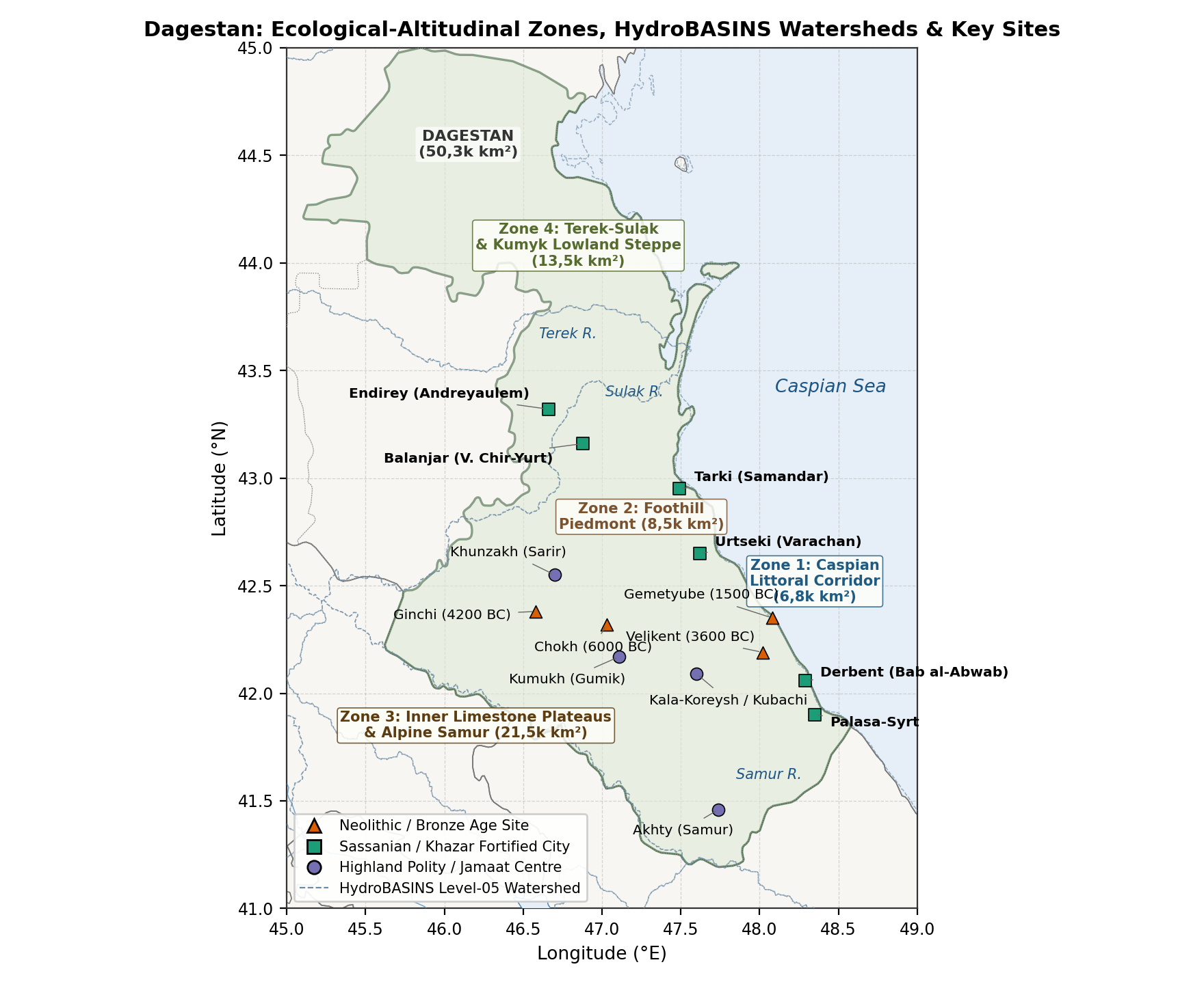
- The Maritime Caspian Corridor (The "Derbent Gate"): A narrow coastal plain (3-35 km wide) between the eastern spurs of the Greater Caucasus and the Caspian shoreline (Zone 1, 6,8k km²), together with the semi-arid Terek-Sulak and Kumyk lowland steppes (Zone 4, 13,5k km²). Serving as the principal land route linking the Eurasian steppe with Transcaucasia and the Iranian plateau, this corridor hosted Early Bronze Age tell settlements (Velikent, Kabaz-Kutan), Sassanian imperial fortifications and garrisons (Derbent / Bab al-Abwab, Palasa-Syrt), early Khazar urban centres (Balanjar / Verkhniy Chir-Yurt, Samandar / Tarki, Varachan / Urtseki, Andreyaulem), and early modern Kumyk and Kaitag principalities [5][13][26][27][28].
- The Foothill Piedmont, Inner Limestone Plateaus, and Alpine Samur Gorges (Zones 2-3, 30,0k km²): Dissected by the four branches of the Koysu (Andi, Avar, Kara, Kazikumukh - converging into the Sulak) and the Samur river basin, Inner and High-Mountain Dagestan formed one of Eurasia's earliest centres of mountain cereal domestication (Chokh, 6000BC) and slope terracing (2000-1000BC) [1][8][29]. Sheltered behind natural limestone defiles (Gunib, Khunzakh, Kumukh, Akusha, Kubachi), highland communities maintained demographic continuity during the Mongol and Timurid invasions that repeatedly depopulated the Caspian lowlands [12][21].
Methodology
Regional Subdivisions
Following the archaeological survey of Abakarov and Davudov (2 128 mapped sites across 38 administrative districts) [12][30] and the geographical classification of Gadzhiev [4], we divide Dagestan (50,3k km²) into four elevation and drainage zones (Table 1):
| Sub-Regional Zone | Elevation | Area (km2) | River Basins | Key Archaeological and Historical Centres |
|---|---|---|---|---|
| 1. Maritime Caspian Corridor | -28 to 200 m | 6,8k | Coastal streams (Ulluchay, Rubas, Darvagchay) and lower Samur delta | Velikent, Derbent, Palasa-Syrt, Urtseki, Tarki, Petrovsk |
| 2. Foothill Piedmont (Predgorye) | 200 to 800 m | 8,5k | Buynaksk, Kaitag, Tabasaran, Sergokala and lower Sulak foothills | Balanjar (V. Chir-Yurt), Andreyaulem, Kala-Koreysh, Khuchni, Temir-Khan-Shura |
| 3. Inner Limestone Plateaus and Alpine Samur | 800 to 4 466 m | 21,5k | Four Koysu basins (Andi, Avar, Kara, Kazikumukh), Gunib-Chokh, Akusha and upper Samur | Chokh, Ginchi, Khunzakh, Kumukh, Akusha, Kubachi, Akhty |
| 4. Terek-Sulak and Kumyk Lowland Steppe | -28 to 100 m | 13,5k | Lower Terek-Sulak delta, Agrakhan peninsula and Nogai-Kumyk plain | Terek-Sulak kurgans, Terki (Terskiy Gorod), Kizlyar, Khasavyurt |
| Total Dagestan | -28 to 4 466 m | 50,3k | All Caspian-draining watersheds of eastern North Caucasus | 2 128 catalogued prehistoric and medieval monuments |
Estimation Methods
To avoid distortion from uneven archaeological survey coverage, regional population totals
- Prehistoric Dwelling Area and Collective Catacomb Estimates (6000-1000BC): For stone-walled Neolithic and Eneolithic settlements (Chokh, Ginchi, Chinna, Mekegi) and Early Bronze Age tell clusters (Velikent), household counts are estimated from excavated circular and rectangular stone dwellings (12-38 m² floor area; one nuclear family of 4,5-5,5 persons per hearth) and cross-checked against the minimum number of individuals (MNI) and life-table mortality in collective catacomb tombs (100-350+ burials per vault over 150-250 years) [5][31][32][33].
- Agricultural Terrace Land-Use Capacity (1500BC-1200AD): Using remote-sensing and soil-chronological surveys of Mid-Mountain Dagestan (48,3% of land surface terraced; ~100k-150k ha of slope terraces) [8][9][10][29], sustainable highland population capacity
is bounded by:
where
Historical Overview
Mesolithic and Neolithic Foundations: Chokh and the Inner Plateaus (10000 - 5000BC)
During the Terminal Pleistocene and Early Holocene (10000-6000BC), human settlement in Dagestan was concentrated in two complementary environments: the karst rock-shelters of the Inner Limestone Plateaus (1 100-1 800 m) and the marine terraces of the Caspian coast (Tarki, Manas, Ulluchay). Excavations directed by V. G. Kotovich (1955-1957) and Hizri Amirkhanov (1980-1985, resumed 2020-2022) at the Chokh settlement (Чохское поселение) in the Gunib district (1 675 m elevation) revealed a six-layer stratigraphic sequence (Layers F-A) spanning the Mesolithic-to-Neolithic transition in the northeastern Caucasus [1][2][3][39]:
- Mesolithic Horizon (Layers E-C, c. 9000-6500BC): Characterised by geometric microliths (asymmetric triangles, trapezes, backed bladelets) and hunting of East Caucasian tur (Capra cylindricornis), bezoar goat (Capra aegagrus), mouflon (Ovis orientalis), and red deer. Seasonal base camps in the Chokh and Rugudja canyons (Rugudja, Kozma-Noho, Mekegi) supported bands of 25-50 individuals (~1,0k-1,8k across Dagestan between 10000 and 8000BC).
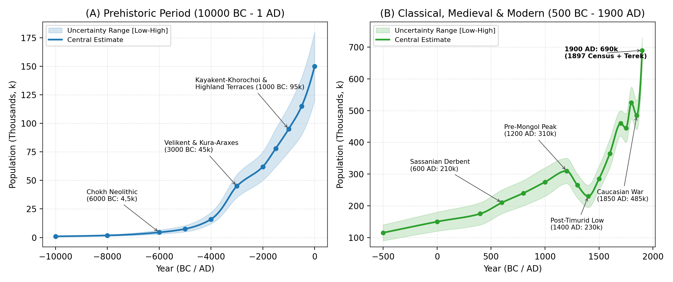
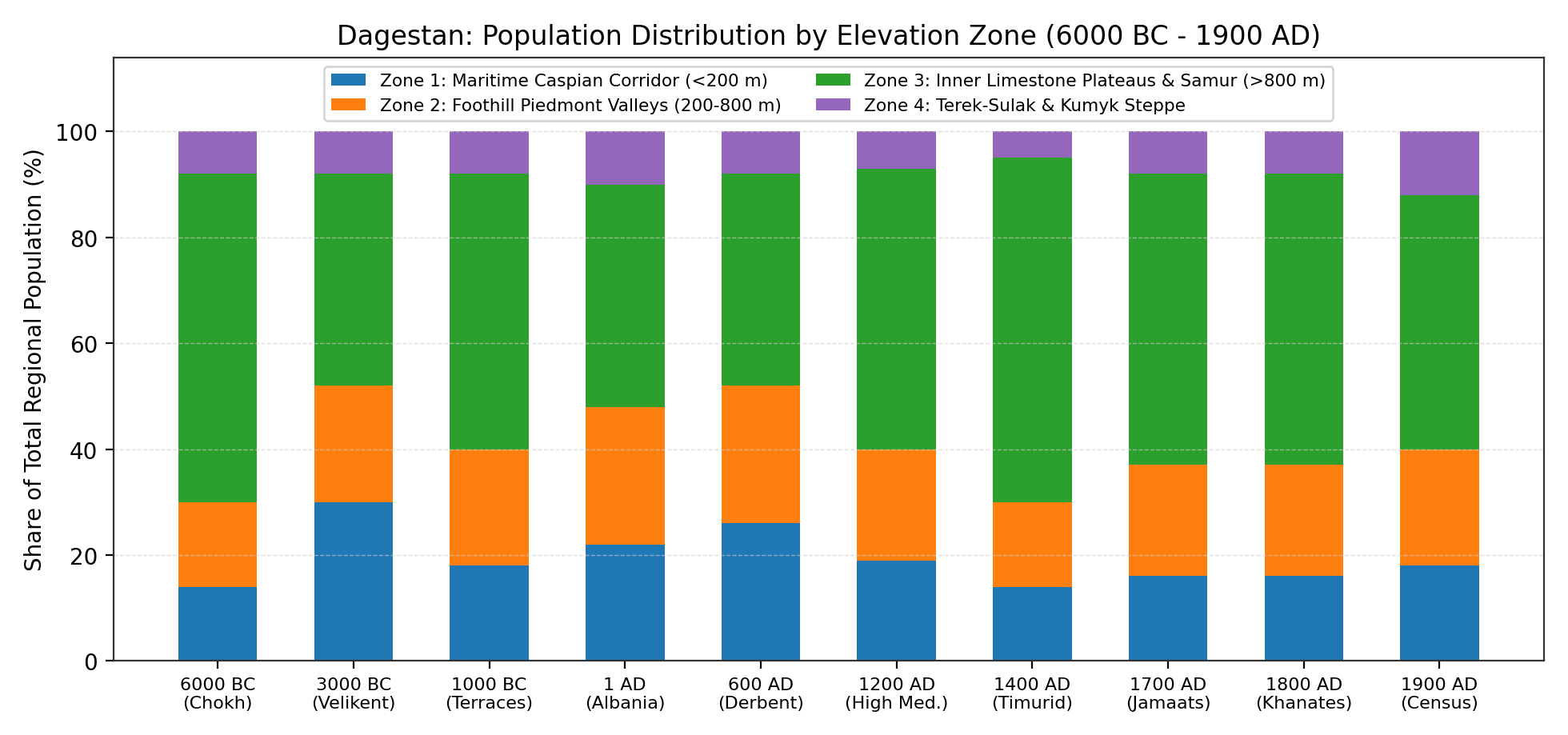
- Neolithic Domestication Horizon (Layers B-A, c. 6000-5000BC): Around 6000BC, Chokh preserves the earliest palaeobotanical and archaeozoological evidence for an indigenous transition to agriculture and stockbreeding in the North Caucasus [1][33]. Palaeobotanical impressions identified by N. R. Yanushevich and G. N. Lisitsyna demonstrate the cultivation of six-row naked and hulled barley (Hordeum vulgare var. coeleste and pallidum) alongside free-threshing hexaploid wheat (Triticum aestivum, T. compactum) and emmer (T. dicoccum). At the same time, domesticated sheep (Ovis aries) and goats (Capra hircus) rose to over 60% of the ungulate bone assemblage, accompanied by permanent dry-stone dwellings with clay-plastered floors and stone-lined hearths [1][2]. This early farming economy raised regional population from 4,5k (3,0k-6,5k) in 6000BC to 7,5k (5,0k-10,5k) by 5000BC, with over 60% residing on the Inner Limestone Plateaus (Zone 3).
Eneolithic and Early Bronze Age: Ginchi, Velikent, and the Kura-Araxes Culture (5000 - 2000BC)
During the 5th millennium BC (Eneolithic, 5000-3600BC), permanent stone-walled farming villages spread across the intermontane basins of Inner Dagestan. Excavations by M. G. Gadzhiev at Ginchi (Гинчи) (Gidatl valley, Shamilsky district, ~1 650 m) and Chinna (Чинна) uncovered closely spaced circular stone dwellings (4,0-5,5 m diameter), defensive perimeter walls, obsidian blades imported from Transcaucasia, and early arsenical copper awls [4][40]. Each fortified village housed 15-30 families (75-150 inhabitants), bringing regional population to 16,0k (12,0k-22,0k) by 4000BC.
Between 3600 and 2000BC, settlement expanded substantially under the Northeastern Caucasian Variant of the Kura-Araxes Culture [4][6][7]:
- Coastal Plain Tell Cluster (Velikent, Kabaz-Kutan, Torpakh-Kala, Dzhemikentskiy): Joint Daghestan-American excavations (1994-1998) directed by M. G. Gadzhiev, Philip L. Kohl, and Rabadan G. Magomedov at Velikent (Великент) (25 km northwest of Derbent on the ancient Ulluchay river fan) established that five natural clay-terrace mounds (Mounds I-V) spanning a 280-hectare archaeological complex were occupied continuously from c. 3600 to 1900BC [5][32][41]. Multi-room mudbrick and pisé buildings, wheel-thrown storage vessels (Mound II), and over 1 500 bronze weapons, ornaments, and casting moulds point to a coastal craft and farming centre of 1,2k-2,5k inhabitants [5][40].
- Velikent Collective Catacomb Tombs and Bioarchaeology (Mounds III-V): Excavations of 13 subterranean collective catacomb tombs at Velikent yielded 100 to over 350 skeletons per tomb (Tomb 1 on Mound III alone contained ~300 individuals alongside >1 500 bronze and carnelian-agate grave goods) [5]. Craniological, dental, and palaeopathological studies by M. B. Mednikova and V. Y. Bakholdina confirm a southern Caucasoid farming population practising surgical cranial trepanation with high post-operative survival, moderate dental caries from cereal gruels, and lineage-based collective burial over 150-250 years [31][42][43]. Across all four elevation zones, Kura-Araxes settlement expansion raised Dagestan's population to 45,0k (35,0k-55,0k) by 3000BC and 62,0k (50,0k-75,0k) by 2000BC.
Middle and Late Bronze and Early Iron Ages: Kayakent-Khorochoi and Highland Terracing (2000 - 400BC)
During the Middle Bronze Age (Gemetyube I-II, Velikent MBA, Irganay) and the Late Bronze and Early Iron Age Kayakent-Khorochoi Culture (Каякентско-хорочоевская культура, 1300-600BC), settlement density increased across both the foothill valleys (Kayakent, Tarki, Karabudakhkent, Zandak-Dagestan) and the Inner Limestone Plateaus (Khorochoi, Gagatli, Kuli, Chirkei) [12][44][45]. Stone-cist cemeteries (каменные ящики) containing 50 to 400+ graves accompany fortified ridge villages (2-8 ha) built in tiered stone masonry.
Interdisciplinary geoarchaeological, radiocarbon, and soil-micromorphological studies led by A. V. Borisov, D. S. Korobov, and I. A. Idrisov (2012-2024) resolved the chronological debate initiated by M. A. Aglarov [11] concerning the age of Dagestan's mountain agricultural terraces [8][9][10][29][46]:
- Chronology of Terrace Construction: Radiocarbon dating of buried humic soils beneath lynchet and stone-retaining terrace walls in the Gunib, Lak, and Akusha basins demonstrates that systematic slope terracing began during the transition from the Middle to Late Bronze Age (c. 1700-1300BC) and reached full valley coverage during the Early Iron Age and Classical Albanian periods [8][9].
- Extent of Terraced Land (48,3% of Mid-Mountain Dagestan): Satellite mapping by Shaev, Borisov, Idrisov, and Korobov (2024) shows that man-made terraces cover 48,3% of the total land area of Mid-Mountain Dagestan (ranging from 29,4% to 64,8% across individual basins) - far exceeding any other part of the Greater Caucasus (16,1% in the Kislovodsk basin, 9,4% in North Ossetia, 5,9% in Ingushetia; see Figure 2) [10]. This ~100k-150k ha network of terraced fields raised regional population to 78,0k (62,0k-95,0k) by 1500BC and 95,0k (75,0k-115,0k) by 1000BC.
Caucasian Albania, Sassanian Bab al-Abwab, and the Palasa-Syrt Necropolis (400BC - 650AD)
Between the 4th century BC and the 4th century AD (Albanian-Sarmatian Period), the Caspian coastal corridor and foothill valleys formed the northern marches of Caucasian Albania and the Sarmatian-Maskut confederations [26][45][47]. Dozens of mudbrick and cobble-walled fortified towns (gorodishcha, 5-25 ha) arose along the coastal plain (Tarki, Urtseki, Karabudakhkent, Torpakh-Kala, Derbent hill), lifting regional population from 115,0k (90,0k-140,0k) in 500BC to 150,0k (120,0k-180,0k) at 1AD and 175,0k (140,0k-210,0k) in 400AD.
During the 5th and 6th centuries AD, the Sassanian shahs Yazdegerd II (438-457), Peroz (459-484), and Khosrow I Anushirvan (531-579) transformed the Derbent defile into the monumental stone fortification system of Derbent (Дербент / Bab al-Abwab) [13][14][34][48][49]:
- Derbent Double Walls and Dag-Bary Mountain Barrier: Replacing Yazdegerd II's 440s AD mudbrick wall (Gil-Bary), Khosrow I constructed (c. 567-569AD, documented in 29 Middle Persian building inscriptions studied by M. S. Gadjiev) the twin parallel stone walls (3,6 km long, 350-450 m apart, enclosing ~145 ha between the 15-ha Naryn-Kala citadel and the Caspian sea moles) together with the 42-km Dag-Bary mountain wall (31 stone forts and towers ascending into Tabasaran) [13][14][49]. Based on Kudryavtsev's study of the 30-35 ha residential shahristan and garrison quarters, Sassanian and early Islamic Derbent housed 15,0k-25,0k inhabitants (20,0k midpoint in 600AD, rising to 35,0k-50,0k during its 10th-century height under the Hashimid emirs when al-Istakhri described it as larger than Ardabil) [13][50].
- The Palasa-Syrt Catacomb Necropolis (Паласа-Сырт): Located 25 km south of Derbent on the Rubas river ridge, the Palasa-Syrt kurgan cemetery (4,5 km long; excavated by V. G. Kotovich, L. B. Gmyrya, and M. S. Gadjiev) comprises 1 500 to 2 000+ earthen kurgans covering T-shaped and longitudinal catacomb graves dated to the late 4th-5th centuries AD [15][26][35][36]. Craniological and funerary evidence (artificial cranial deformation, polychrome fibulae, Sassanian seals, and weapons) identifies a multi-ethnic Alanic-Maskut-Hunnic border garrison guarding the Derbent pass of 3,5k-5,0k living inhabitants over 4-5 generations [15][26].
Early and High Middle Ages: Khazar Cities, Sarir, Islamisation, and the Mongol and Timurid Invasions (650 - 1500AD)
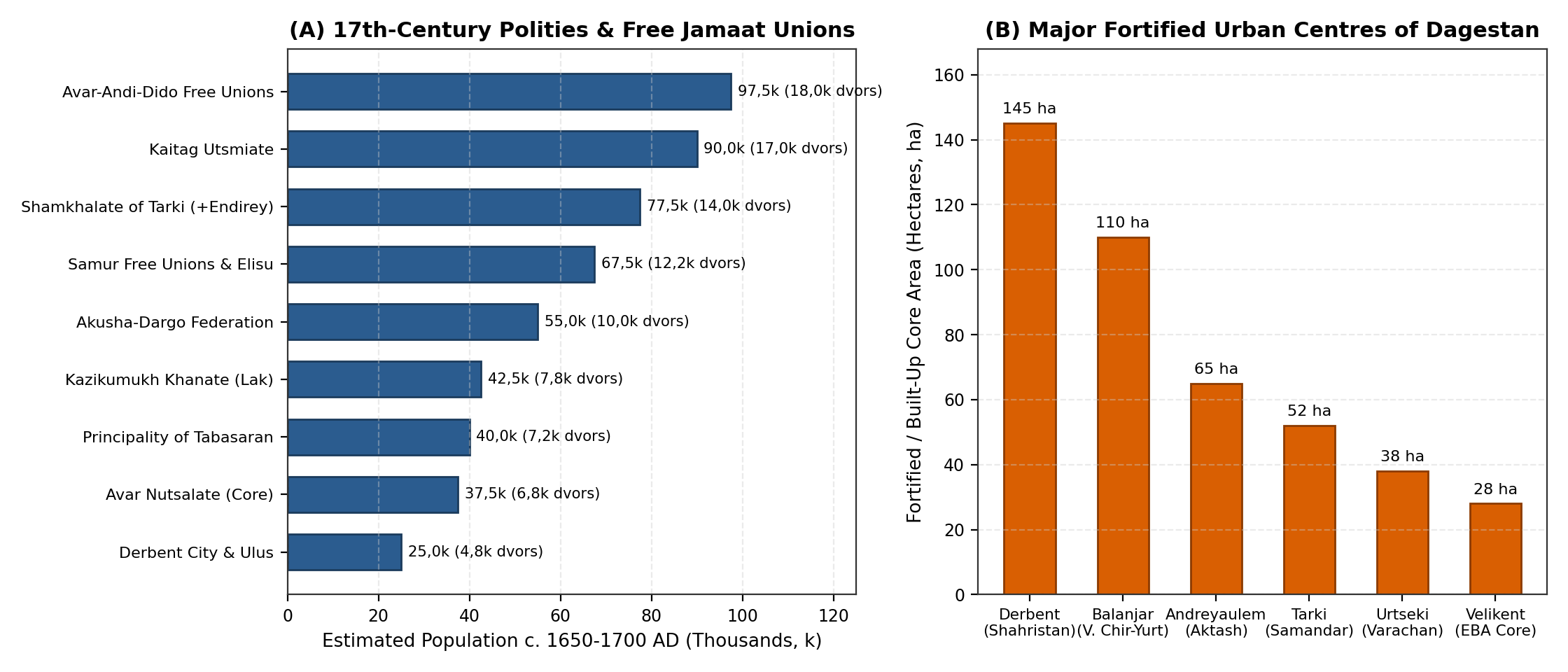
Between 650 and 965AD, northern and coastal Dagestan served as the early urban core of the Khazar Khaganate and the Kingdom of the Huns (Savirs), while the Inner Limestone Plateaus were consolidated under the Christian and syncretic Avar kingdom of Sarir (Сарир, capital at Khunzakh) and the early principalities of Lakz (South Dagestan), Tabasaran, Zirikhgeran (Kubachi), Kaitag, and Gumik (Kumukh) [27][28][51][52]. Archaeological excavations across the northern foothills and coastal corridor document four major fortified towns (Figure 3B):
- Balanjar (Verkhniy Chir-Yurt on the Sulak exit): Enclosing ~110 ha behind stone and mudbrick ramparts (2,5 km wall perimeter), accompanied by three large catacomb and kurgan cemeteries (>2 000 burials) and two early Christian churches; estimated population 12,0k-18,0k prior to its capture by the Arab general al-Jarrah ibn Abdallah in 722/723AD [27][28].
- Samandar (Tarki / Makhachkala-Karaman plain): Enclosing >50 ha of stone terraces and vineyard gardens (40 000 vineyards reported by al-Mas'udi and Ibn Hawqal prior to Svyatoslav's 965-969 campaign); estimated population 10,0k-15,0k [12][27].
- Varachan (Urtseki fortified city): Capital of the Caspian Huns (Savirs), comprising a 38-40 ha three-tiered stone citadel and agricultural suburb (6,0k-10,0k inhabitants) [15][51].
- Andreyaulem (Endirey on the Aktash river): A 65-ha fortified town controlling the Terek-Sulak piedmont crossroads (8,0k-12,0k inhabitants) [12][27][53].
During the High Middle Ages (1000-1220AD), the spread of Sunni (Shafi'i) Islam (Kala-Koreysh, Kumukh, Richa, Tsakhur, where a madrasa was founded in 1075AD) and the growth of highland craft specialisation (Kubachi armourers, Sulevkent potters, Khunzakh and Kumukh market towns) raised Dagestan's total population to 310,0k (270,0k-350,0k) around 1200AD [12][17][52].
This medieval high point was interrupted by two destructive foreign invasions [18][37]:
- The Mongol Campaigns (1220-1222 and 1239-1240): Subutai and Jebe bypassed Derbent in 1221, and Bukdai sacked Derbent, Richa (where a 1239 Arabic inscription records the slaughter), Kumukh (1240), and the coastal plain [17][52]. Lowland cities shrank considerably (Guillaume de Rubruck noted Derbent's reduced perimeter in 1254), pulling total regional population down to 265,0k (225,0k-300,0k) by 1300AD.
- Timur's Campaigns (1395-1396): Following his victory over Tokhtamysh on the Terek (April 1395), Timur ravaged the Kumyk plain, Kaitag, Akusha/Ushkudzha, Nerges, and the foothill fortresses (the Zafar-nama of Nizam al-Din Shami and Sharaf al-Din Yazdi records the killing of Kaitag and Kumyk defenders and the destruction of piedmont strongholds) [17][18][19]. Regional population fell to a late-medieval low of 230,0k (195,0k-265,0k) in 1400AD, with 65% of the surviving population concentrated on the fortified Inner Plateaus and Samur gorges (Zone 3).
Early Modern Principalities and Free Jamaat Unions (1500 - 1700AD)
Between 1450 and 1700AD, Dagestan experienced steady demographic and political recovery (285,0k in 1500AD -> 365,0k in 1600AD -> 460,0k [420,0k-500,0k] in 1700AD). Drawing on the archival studies of B. G. Aliev and M.-S. K. Umakhanov alongside M. A. Aglarov's ethnographic work on the mountain jamaat [19][20][21][54][55][56][57], 17th-century Dagestan was divided between feudal principalities and autonomous rural unions (Figure 3A and Table 2):
- Major Feudal Principalities (~45% of Regional Population):
- Shamkhalate of Tarki (Тарковское шамхальство) and Endirey / Zasulak Kumyk Domains: Centred at Tarki (~1,5k-2,0k households; 8,0k-10,0k inhabitants visited by Adam Olearius in 1638, Evliya Çelebi in 1666, and Jan Struys in 1670), Kafir-Kumukh, Buynak, and the autonomous Sultanate of Endirey (Andreyaulem, ~1,5k households). Russian Posolskiy Prikaz records (1614-1650) credit the Shamkhal and the Endirey rulers (Sultan-Mahmud) with 12 000-15 000 mounted and foot militia, corresponding to 12,0k-16,0k households (65,0k-85,0k inhabitants) [19][20].
- Kaitag Utsmiate (Кайтагское уцмийство): Spanning Lower Kaitag (Madzhalis, Bashly with ~1,5k households) and Upper Kaitag/Dargwa (Urkarakh, Kubachi), governed under the early-17th-century Codex of Rustam Khan. Capable of fielding 15 000-20 000 warriors (15,0k-19,0k households; 80,0k-100,0k inhabitants) [19][20].
- Kazikumukh Khanate (Казикумухское ханство): Centred at Kumukh (~1,2k-1,5k stone multi-storey houses) across the Lak basin; 7,0k-8,5k households (38,0k-46,0k inhabitants) [20].
- Avar Nutsalate (Аварское нуцальство): Centred on the Khunzakh plateau (~700-1 000 households in Khunzakh and Tobot villages), numbering 6,0k-7,5k core households (32,0k-42,0k inhabitants) [19][21][58].
- Principality of Tabasaran (Maisumate and Qadiate of North Tabasaran): Documented in the 1635 decrees of Maisum Ali-Bek [37], numbering 6,5k-8,0k households (35,0k-45,0k inhabitants) [17].
- Safavid Governorate of Derbent (Derbent City and Ulus): Following Shah Abbas I's 1606 reconquest and resettlement of Bayat and Qurchi garrisons, Derbent city (~2,0k-2,5k houses; 10,0k-14,0k urban residents) and its coastal ulus villages numbered 4,0k-5,5k households (20,0k-30,0k inhabitants) [13][16].
- Self-Governing Free Jamaat Unions (Вольные общества, ~55% of Regional Population):
- Over 60 autonomous federations (soyuzy sel'skikh obshchin) governed by elected elders (chankas, qadis, kartas) and customary adat law occupied the Dargwa plateaus and the Avar-Andi-Dido and Samur alpine gorges [21][54][55][56][57].
- The Akusha-Dargo Upper Dargwa Confederation (Akusha, Tsudakhar, Usisha, Mugi, Mekegi) comprised 9,0k-11,0k households (48,0k-60,0k inhabitants).
- The Avar, Andi, and Tsez/Dido Free Unions (Gidatl, Andalal around Chokh-Sogratl, Karata, Bagulal, Chamalyal, Tindi, Dido, Antsukh, Dzhurmut, Koysubulu, Antl-Ratl) totalled 16,0k-20,0k households (85,0k-110,0k inhabitants) [21][54][56].
- The Samur Valley Free Unions and Elisu Sultanate (Akhty-para, Dokuz-para, Altı-para, Rutul Magal, Tsakhur / Elisu) numbered 11,0k-13,5k households (60,0k-75,0k inhabitants) [16][54].
| Polity / Free Jamaat Union | Primary Centres | Households (Dvors) | Militia (Sabres) | Estimated Population |
|---|---|---|---|---|
| Avar, Andi and Dido Free Unions (Andalal, Gidatl, Antsukh, Dido, Andi) | Chokh, Sogratl, Khidi, Andi, Botlikh, Bezhta | 16,0k - 20,0k | 18,0k - 22,0k | 85,0k - 110,0k |
| Kaitag Utsmiate (Lower Kaitag and Upper Kaitag/Dargwa) | Madzhalis, Bashly, Urkarakh, Kubachi | 15,0k - 19,0k | 15,0k - 20,0k | 80,0k - 100,0k |
| Shamkhalate of Tarki and Endirey / Zasulak Kumyk Domains | Tarki, Endirey, Kafir-Kumukh, Buynak | 12,0k - 16,0k | 12,0k - 15,0k | 65,0k - 85,0k |
| Samur Free Unions (Akhty-para, Dokuz-para, Rutul) and Tsakhur/Elisu | Akhty, Mikrakh, Rutul, Tsakhur | 11,0k - 13,5k | 10,0k - 13,0k | 60,0k - 75,0k |
| Akusha-Dargo Upper Dargwa Federation (Akusha, Tsudakhar, Usisha, Mekegi) | Akusha, Tsudakhar, Usisha, Mugi | 9,0k - 11,0k | 10,0k - 12,0k | 48,0k - 60,0k |
| Kazikumukh Khanate (Kumukh and Lak Basin) | Kumukh, Tovuz, Khosrekh | 7,0k - 8,5k | 7,0k - 9,0k | 38,0k - 46,0k |
| Principality of Tabasaran (Maisumate and Qadiate of Tabasaran) | Khuchni, Dzhalgan, Rukel | 6,5k - 8,0k | 6,0k - 8,0k | 35,0k - 45,0k |
| Avar Nutsalate (Khunzakh Plateau Core) | Khunzakh, Arani, Untsukul | 6,0k - 7,5k | 6,0k - 8,0k | 32,0k - 42,0k |
| Safavid Governorate of Derbent (Derbent City and Coastal Ulus) | Derbent (Naryn-Kala and Shahristan) | 4,0k - 5,5k | 3,5k - 5,0k | 20,0k - 30,0k |
| Unadjusted Sum of Sub-Regional Polities | All 9 polity/confederation groupings | 86,5k - 109,0k | 87,5k - 112,0k | 463,0k - 593,0k |
| Adopted Regional Benchmark (Adjusted for Shared Tributary Margins) | Republic of Dagestan (50,3k km2) | 82,0k - 95,0k | 80,0k - 95,0k | 460,0k (420,0k - 500,0k) |
The Eighteenth and Nineteenth Centuries (1700 - 1900AD)
During the 18th and 19th centuries, Dagestan's population experienced two sharp wartime contractions followed by sustained post-1860 demographic growth under Russian imperial administration [22][25][59][60]:
- The Caspian Campaign and Nadir Shah's Invasions (1700-1800AD): During the 1720s, anti-Safavid uprisings in Southern Dagestan and Peter I's Persian Campaign (1722-1723, which established the fortress of Svyatoy Krest on the Sulak and Russian garrisons at Derbent and Tarki before Kizlyar was founded on the Terek in 1735) disrupted coastal agriculture. Even greater devastation accompanied the three Dagestani campaigns of the Iranian ruler Nadir Shah Afshar in 1734, 1735, and especially 1741-1743 [59][60]. Before his defeat by the combined Avar, Lak, and Dargwa militia at Andalal (Sogratl-Chokh) and Aymaki in September 1741, Nadir Shah burned dozens of villages across Kaitag, Tabasaran, Mehtuli, and Kazikumukh, reducing Dagestan's population slightly from 460,0k (1700AD) to 445,0k (400,0k-490,0k) in 1750AD. A half-century of relative internal recovery and expanding trade through Kizlyar, Derbent, and Tarki subsequently lifted regional population to 525,0k (475,0k-575,0k) by 1800AD [22][59].
- The Caucasian War and the Caucasian Imamate (1801-1859): Russian annexation of the Derbent, Baku, and Quba khanates (confirmed by the 1813 Treaty of Gulistan) and General A. P. Yermolov's punitive expeditions (1818-1826, establishing the fortresses of Vnezapnaya at Endirey in 1819 and Burnaya above Tarki in 1821) provoked the rise of the Caucasian Imamate under the three Imams Ghazi Muhammad (1829-1832), Hamzat Bek (1832-1834), and Shamil (1834-1859) [22][61]. Three decades of siege warfare (Gimry 1832, Akhulgo 1839, Dargo 1845, Gergebil and Salta 1847, Chokh 1849, and Gunib 1859), cholera outbreaks, crop destruction, and post-1859 muhajir emigration of ~15,0k-20,0k Dagestani mountaineers to the Ottoman Empire reduced total population to 485,0k (440,0k-530,0k) around 1850AD [22][25][61].
- Formation of Dagestan Oblast (1860), the 1886 Family Lists, and the 1897 Imperial Census: Following Shamil's capture at Gunib (25 August 1859), imperial authorities organised Dagestan Oblast (1860, administrative capital at Temir-Khan-Shura [modern Buynaksk], divided into nine okrugs: Avar, Andi, Gunib, Dargwa, Kazikumukh, Kaitag-Tabasaran, Kyurin, Samur, and Temir-Khan-Shura) while the northern Kumyk and Nogai plains north of the Sulak (the Khasavyurt and Kizlyar okrugs) were placed under Terek Oblast [38][62][63]. Early military-statistical enumerations in the 1860s recorded ~450,0k-480,0k inhabitants in Dagestan Oblast proper, rising in the 1886 family lists (posemeynye spiski) to 592,8k in Dagestan Oblast [22][25][38]. In the First General Census of the Russian Empire (28 January 1897) edited by N. A. Troynitskiy and E. I. Kozubskiy [23][24], Dagestan Oblast recorded 571 154 de facto present inhabitants (slightly below the de jure permanent population because ~50,0k-80,0k highland male seasonal labourers [otkhodniki] were working in winter in Baku oilfields, Tiflis, and Terek towns), broken down by linguistic group as 158,6k Avars-Ando-Tsez (27,8%), 121,4k Dargwas and Kubachis (21,3%), 94,6k Kyurins/Lezgins (16,6%), 76,4k Kazi-Kumukhs/Laks (13,4%), 32,6k Kumyks in Temir-Khan-Shura and Kaitag (5,7%), 32,1k Tatars/Azerbaijanis and Tats around Derbent (5,6%), and 22,0k Tabasarans, Aguls, Rutuls, and Tsakhurs [23][24][63]. Adding the Khasavyurt Okrug (70 800 inhabitants in 1897, including 26,6k Kumyks, 18,1k Chechens/Aukh, and Russian/Jewish settlers) and the Dagestani sector of the Kizlyar Okrug (Kizlyar town, Terek Cossack stanitsas, and Karanogai steppe camps, ~45,0k-50,0k) yields a well-documented total population within the modern borders of the Republic of Dagestan of 690,0k (650,0k-730,0k, or 13,72 persons/km²) by 1900AD [22][25][62]. The completion of the Vladikavkaz Railway through Petrovsk-Port (Makhachkala, 9 753 inhabitants in 1897) to Derbent (14 649 inhabitants) and Baku in 1893-1900 initiated rapid urban growth along the Caspian littoral (Zone 1: 124,0k; Zone 4: 83,0k in 1900AD) [25].
Limitations
Three main constraints affect historical population estimates for Dagestan:
- Caspian Sea-Level Changes: Fluctuations of the Caspian Sea between -34 m (Derbent Regression, 6th-10th centuries AD) and -22 m (Late Medieval Transgression, 14th-17th centuries AD) submerged the seaward moles of Derbent and several coastal Bronze Age sites while shifting the lower Terek-Sulak delta channels [5][13].
- Simultaneous Cultivation of Highland Terraces: Although 48,3% of Mid-Mountain Dagestan preserves man-made agricultural terraces [10], fallow rotation and post-Timurid village consolidation mean that only 45-65% of total terraced land was cultivated at any single benchmark date [8][9].
- Overlapping Tributary Claims and Seasonal Otkhodnichestvo: In the 17th century, the Shamkhal of Tarki, the Utsmi of Kaitag, and the Khan of Kazikumukh frequently claimed authority over the same border jamaats when negotiating with Russian envoys, requiring a ~10-15% deduction from raw militia sums [19][20]. Conversely, in the January 1897 census, winter seasonal migration (otkhodnichestvo) of 50,0k-80,0k highland men to Baku and Terek Oblast depressed the de facto count of mountain okrugs relative to the 1886 de jure family lists [23][25].
Conclusion
From 10000BC to 1900AD, Dagestan developed from an early mountain centre of wheat, barley, and sheep-goat domestication at Chokh (4,5k in 6000BC) into the most densely terraced and urbanised region of the Eastern Caucasus (690,0k or 13,72 persons/km² by 1900AD). The combination of the irrigated urban corridor along the Caspian coast (Velikent, Derbent, Urtseki, Tarki, Balanjar, Petrovsk-Port) and the terraced stone villages of the Inner Limestone Plateaus (Chokh, Khunzakh, Kumukh, Akusha, Kubachi) enabled Dagestan to withstand the 13th-century Mongol and 1395 Timurid invasions, Nadir Shah's 1741-1743 campaigns, and the Caucasian War (1829-1859) with much smaller long-term population losses than the open steppes and piedmont plains of Central and Northwestern Ciscaucasia.
Appendix
Population Estimates
| Benchmark | Zone 1: Littoral (6,8k km2) | Zone 2: Piedmont (8,5k km2) | Zone 3: Highlands (21,5k km2) | Zone 4: Steppe (13,5k km2) | Total Midpoint | Uncertainty Range [Low - High] | Density (p/km2) |
|---|---|---|---|---|---|---|---|
| 10000BC | 0,15k | 0,20k | 0,55k | 0,10k | 1,0k | 0,6k - 1,5k | 0,02 |
| 8000BC | 0,25k | 0,35k | 1,05k | 0,15k | 1,8k | 1,2k - 2,5k | 0,04 |
| 6000BC | 0,65k | 0,70k | 2,80k | 0,35k | 4,5k | 3,0k - 6,5k | 0,09 |
| 5000BC | 1,1k | 1,2k | 4,6k | 0,6k | 7,5k | 5,0k - 10,5k | 0,15 |
| 4000BC | 3,2k | 3,2k | 8,3k | 1,3k | 16,0k | 12,0k - 22,0k | 0,32 |
| 3000BC | 13,5k | 9,9k | 18,0k | 3,6k | 45,0k | 35,0k - 55,0k | 0,89 |
| 2000BC | 14,5k | 13,5k | 29,0k | 5,0k | 62,0k | 50,0k - 75,0k | 1,23 |
| 1500BC | 15,5k | 17,0k | 39,5k | 6,0k | 78,0k | 62,0k - 95,0k | 1,55 |
| 1000BC | 17,0k | 21,0k | 49,5k | 7,5k | 95,0k | 75,0k - 115,0k | 1,89 |
| 500BC | 23,0k | 27,5k | 53,5k | 11,0k | 115,0k | 90,0k - 140,0k | 2,29 |
| 1AD | 33,0k | 39,0k | 63,0k | 15,0k | 150,0k | 120,0k - 180,0k | 2,98 |
| 400AD | 42,0k | 45,5k | 73,5k | 14,0k | 175,0k | 140,0k - 210,0k | 3,48 |
| 600AD | 54,5k | 54,5k | 84,0k | 17,0k | 210,0k | 175,0k - 250,0k | 4,17 |
| 800AD | 57,5k | 62,5k | 101,0k | 19,0k | 240,0k | 200,0k - 280,0k | 4,77 |
| 1000AD | 55,0k | 60,5k | 140,0k | 19,5k | 275,0k | 230,0k - 320,0k | 5,47 |
| 1200AD | 59,0k | 65,0k | 164,0k | 22,0k | 310,0k | 270,0k - 350,0k | 6,16 |
| 1300AD | 42,0k | 48,0k | 159,0k | 16,0k | 265,0k | 225,0k - 300,0k | 5,27 |
| 1400AD | 32,0k | 37,0k | 149,5k | 11,5k | 230,0k | 195,0k - 265,0k | 4,57 |
| 1500AD | 43,0k | 51,0k | 174,0k | 17,0k | 285,0k | 250,0k - 325,0k | 5,67 |
| 1600AD | 58,0k | 73,0k | 208,0k | 26,0k | 365,0k | 320,0k - 410,0k | 7,26 |
| 1700AD | 73,5k | 96,5k | 253,0k | 37,0k | 460,0k | 420,0k - 500,0k | 9,15 |
| 1750AD | 68,0k | 92,0k | 250,0k | 35,0k | 445,0k | 400,0k - 490,0k | 8,85 |
| 1800AD | 84,0k | 110,0k | 289,0k | 42,0k | 525,0k | 475,0k - 575,0k | 10,44 |
| 1850AD | 78,0k | 102,0k | 262,0k | 43,0k | 485,0k | 440,0k - 530,0k | 9,64 |
| 1900AD | 124,0k | 152,0k | 331,0k | 83,0k | 690,0k | 650,0k - 730,0k | 13,72 |
Sources
1.Amirkhanov, H. A. Chokhskoye poseleniye: chelovek i yego kul'tura v mezolite i neolite gornogo Dagestana [The Chokh Settlement: Man and His Culture in the Mesolithic and Neolithic of Mountainous Dagestan]. Nauka, 1987.
2.Amirkhanov, H. A. "Chokhskaya neoliticheskaya kul'tura: opredeleniye i khronologiya [The Chokh Neolithic Culture: Definition and Chronology]." Istoriya, Arkheologiya i Etnografiya Kavkaza, vol. 18, no. 4, 2022, pp. 1030-1047, https://doi.org/10.32653/CH1841030-1047.
3.Davudov, O. M. "Hizri Amirkhanovich Amirkhanov (k 60-letiyu so dnya rozhdeniya) [Hizri Amirkhanovich Amirkhanov: On His 60th Birthday and Investigations of Chokh]." Istoriya, Arkheologiya i Etnografiya Kavkaza, no. 4, 2009, pp. 176-192, Archived PDF (davudov_omar_mallamagomedovich_2009_hizri_amirhanovich_amirhanov_k_60_letiy.pdf).
4.Gadzhiev, M. G. Rannezemledel'cheskaya kul'tura Severo-Vostochnogo Kavkaza: Epokha eneolita i ranney bronzy. Nauka, 1991.
5.Gadzhiev, M. G., et al. "The 1995 Daghestan-American Velikent Expedition: Excavations in Daghestan, Russia." Eurasia Antiqua, vol. 3, 1997, pp. 181-222.
6.Magomedov, R. G. Materialy k izucheniyu kul'tur epokhi bronzy v Primorskom Dagestane. IIAE DNTs RAN, 2000.
7.Magomedov, R. G. "Severo-Vostochnyy Kavkaz i kuro-arakskaya kul'turno-istoricheskaya obshchnost': novyye perspektivy staroy problemy [The Northeastern Caucasus and the Kura-Araxes Community]." Vestnik Instituta Istorii, Arkheologii i Etnografii, no. 4, 2005, pp. 60-65, Archived PDF (magomedov_rabadan_gadzhievich_2005_severo_vostochnyy_kavkaz_i_kuro_arakskay.pdf).
8.Borisov, A. V., et al. "Opyt kompleksnogo izucheniya drevnego zemledeliya v Gornom Dagestane (na primere Gunibskogo plato)." Rossiyskaya Arkheologiya, no. 4, 2012, pp. 24-36.
9.Korobov, D. S., and A. V. Borisov. "Zemledel'cheskiye terrasy vo Vnutrennem Dagestane: proiskhozhdeniye i khronologiya [Agricultural Terraces in Inner Dagestan: Origin and Chronology]." Rossiyskaya Arkheologiya, no. 3, 2020, pp. 68-83.
10.Shaev, I. A., et al. "Zemledel'cheskiye terrasy v srednegornoy zone Bol'shogo Kavkaza [Agricultural Terraces in the Mid-Mountain Zone of the Greater Caucasus]." Regional'nyye Geosistemy, vol. 48, no. 4, 2024, pp. 503-514, https://doi.org/10.52575/2712-7443-2024-48-4-503-514.
11.Aglarov, M. A. "Tekhnika sooruzheniya terrasnykh poley i voprosy evolyutsii form sobstvennosti v Dagestane (do XX v.)." Studia Pontocaucasica, vol. 1, 1986, pp. 74-92.
12.Abakarov, A. I., and O. M. Davudov. Arkheologicheskaya karta Dagestana [Archaeological Map of Dagestan]. Nauka, 1993.
13.Kudryavtsev, A. A. Drevniy Derbent [Ancient Derbent]. Nauka, 1982.
14.Gadjiev, M. S. "Construction Activities of Kavadh I and Khusraw I Anushirvan in the Caucasus and the Fortifications of Derbent." Iran and the Caucasus, vol. 21, no. 2, 2017, pp. 121-147.
15.Gmyrya, L. B. Strana gunnov u Kaspiyskikh vorot: Prikaspiyskiy Dagestan v epokhu Velikogo pereseleniya narodov. Dagestanskoye Knizhnoye Izdatel'stvo, 1995.
16.Ikhilov, M. M. Narody lezginskoy gruppy: etnograficheskoye issledovaniye proshlogo i nastoyashchego lezgin, tabasarantsev, rutul'tsev, tsakhurov, agulov. Dagestanskiy Filial AN SSSR, 1967.
17.Aliev, B. G., and M.-S. K. Umakhanov. Istoricheskaya geografiya Dagestana XVII - nach. XIX v. (Yuzhnyy Dagestan i Tabasaran). IIAE DNTs RAN, 2001.
18.Gasanov, M. R., and E. M. Magomedova. "Iz istorii srednevekovogo Dagestana: Tabasaran v XIV-XV vv. [From the History of Medieval Dagestan: Tabasaran in the 14th-15th Centuries]." Izvestiya DGPU. Obshchestvennyye i Gumanitarnyye Nauki, vol. 18, no. 4, 2024, pp. 12-17, https://doi.org/10.31161/1995-0667-2024-18-4-12-17, Archived PDF (gasanov_magomed_radzhabovich_2024_iz_istorii_srednevekovogo_dagestana_tabas.pdf).
19.Aliev, B. G., et al. Iz istorii srednevekovogo Dagestana [From the History of Medieval Dagestan]. IIAE DNTs AN SSSR, 1975.
20.Umakhanov, M.-S. K. Vzaimootnosheniya feodal'nykh vladeniy i osvoboditel'naya bor'ba narodov Dagestana v XVII veke [Mutual Relations of Feudal Principalities and the Peoples of Dagestan in the 17th Century]. Dagestanskiy Filial AN SSSR, 1973.
21.Aglarov, M. A. Sel'skaya obshchina v Nagornom Dagestane v XVII - nachale XIX v. [The Rural Community in Mountainous Dagestan in the 17th - Early 19th Century]. Nauka, 1988.
22.Kabuzan, V. M. Naseleniye Severnogo Kavkaza v XIX-XX vekakh: Etnostatisticheskoye issledovaniye [The Population of the North Caucasus in the 19th-20th Centuries: An Ethnostatistical Study]. Russko-Baltiyskiy Informatsionnyy Tsentr BLITs, 1996.
23.Kozubskiy, E. I. Dagestanskiy sbornik. Vypusk I [Dagestan Collection, Issue I: Statistical Summary and the 1897 Census]. Russkaya Tipografiya V. M. Sorokina, 1902.
24.Troynitskiy, N. A. Pervaya vseobshchaya perepis' naseleniya Rossiyskoy imperii, 1897 g. Tom LXII: Dagestanskaya oblast' [First General Census of the Population of the Russian Empire, 1897. Vol. 62: Dagestan Oblast]. Tsentral'nyy Statisticheskiy Komitet MVD, 1905.
25.Nagieva, M. K. "Rasseleniye naseleniya i migratsionnyye protsessy v Dagestane vo vtoroy polovine XIX - nachale XX vv. [Settlement of Population and Migration Processes in Dagestan in the Second Half of the 19th - Early 20th Century]." Istoriya, Arkheologiya i Etnografiya Kavkaza, vol. 1, no. 4, 2005, pp. 54-63, https://cyberleninka.ru/article/n/rasselenie-naseleniya-i-migratsionnye-protsessy-v-dagestane-vo-vtoroy-polovine-xix-nachale-xx-vv, Archived PDF (rasselenie_naseleniya_i_migratsionnye_protsessy_v_dagestane_vo_vt.pdf).
26.Gadjiev, M. S. "On the Construction Date of the Derbent Fortification Complex." Iran and the Caucasus, vol. 12, no. 1, 2008, pp. 1-15, https://doi.org/10.1163/157338408X326163.
27.Magomedov, M. G. Obrazovaniye Khazarskogo kaganata: Po materialam arkheologicheskikh issledovaniy i pis'mennym dannym. Nauka, 1983.
28.Fedchenko, O. D. "Lokalizatsiya khazarskikh gorodov: ot Sarkela do Samandara [Localisation of Khazar Cities: From Sarkel to Samandar and Balanjar]." Kochevaya Tsivilizatsiya: Istoricheskiye Issledovaniya, vol. 3, no. 2, 2023, pp. 47-62, https://doi.org/10.53315/2782-3377-2023-3-2-47-62, Archived PDF (fedchenko_o_d_2023_lokalizatsiya_hazarskih_gorodov_ot_sarkela_do_samandara.pdf).
29.Idrisov, I. A., et al. "Pochvy zemledel'cheskikh terras Gunibskogo plato [Soils of the Agricultural Terraces of the Gunib Plateau]." Izvestiya DGPU. Yestestvennyye i Tochnyye Nauki, vol. 12, no. 2, 2018, pp. 41-50, https://doi.org/10.31161/1995-0675-2018-12-2-41-50, Archived PDF (idrisov_idris_abdulbutaevich_2018_pochvy_zemledelcheskih_terras_gunibskogo.pdf).
30.Budaychiev, A. L. "Arkheologicheskiye razvedki na territorii Suleyman-Stal'skogo rayona v 2013 godu [Archaeological Surveys in Suleyman-Stalskiy District in 2013]." Vestnik Instituta Istorii, Arkheologii i Etnografii, no. 1, 2014, pp. 150-154, https://cyberleninka.ru/article/n/arheologicheskie-razvedki-na-territorii-suleyman-stalskogo-rayona-v-2013-godu, Archived PDF (budaychiev_a_l_2014_arheologicheskie_razvedki_na_territorii_suleyman_stalsk.pdf).
31.Mednikova, M. B., et al. "Bioarchaeology of the Collective Catacomb Burials of Velikent (Early and Middle Bronze Age, Dagestan)." Kratkiye Soobshcheniya Instituta Arkheologii (KSIA), vol. 259, 2020, pp. 210-226.
32.Kohl, Philip L. The Making of Bronze Age Eurasia. Cambridge University Press, 2007.
33.Davudov, O. M. "Vydayushchiysya uchenyy, talantlivyy organizator (k 65-letiyu akademika H. A. Amirkhanova) [On the 65th Birthday of Academician H. A. Amirkhanov]." Vestnik Instituta Istorii, Arkheologii i Etnografii, no. 4, 2014, pp. 182-196, Archived PDF (davudov_o_m_2014_vydayuschiysya_uchenyy_talantlivyy_organizator_k_65_letiyu.pdf).
34.Gadjiev, M. S., et al. "Raskopki v tsitadeli Derbenta v 2011 g. [Excavations in the Citadel of Derbent in 2011]." Vestnik Instituta Istorii, Arkheologii i Etnografii, no. 1, 2013, pp. 56-81, Archived PDF (gadzhiev_m_s_2013_raskopki_v_tsitadeli_derbenta_v_2011_g.pdf).
35.Gmyrya, L. B., and A. K. Abiev. "Arkheologicheskiye raskopki na Palasa-Syrtskom kurgannom mogil'nike IV-V vv. v 2009-2011 gg. [Archaeological Excavations at the 4th-5th Century Palasa-Syrt Kurgan Cemetery]." Izvestiya DGPU. Obshchestvennyye i Gumanitarnyye Nauki, no. 3, 2012, pp. 16-20, Archived PDF (gmyrya_lyudmila_borisovna_2012_arheologicheskie_raskopki_na_palasa_syrtskom.pdf).
36.Gmyrya, L. B., and M. Saipudi. "Katakombnyye pogrebeniya Palasa-Syrtskogo kurgannogo mogil'nika IV-V vv. [Catacomb Burials of the 4th-5th Century Palasa-Syrt Kurgan Cemetery]." Istoriya, Arkheologiya i Etnografiya Kavkaza, vol. 16, no. 1, 2020, pp. 115-136.
37.Dadaev, Yu. U. "Sistema organov vlasti i upravleniya feodal'nykh vladeniy Dagestana [The System of Government and Administration of the Feudal Principalities of Dagestan]." Vestnik Instituta Istorii, Arkheologii i Etnografii, no. 1, 2014, pp. 25-39, https://cyberleninka.ru/article/n/sistema-organov-vlasti-i-upravleniya-feodalnyh-vladeniy-dagestana, Archived PDF (dadaev_yu_u_2014_sistema_organov_vlasti_i_upravleniya_feodalnyh_vladeniy_da.pdf).
38.Kozubskiy, E. I. Pamyatnaya knizhka Dagestanskoy oblasti [Memorial Book of Dagestan Oblast]. Russkaya Tipografiya V. M. Sorokina, 1895.
39.Kotovich, V. G. Kamennyy vek Dagestana [The Stone Age of Dagestan]. Dagestanskiy Filial AN SSSR, 1964.
40.Gadzhiev, M. G., and S. N. Korenevskiy. "Metall Velikentskoy katakomby [Metalwork of the Velikent Catacomb]." Drevniye remesla, torgovlya i khozyaystvo Dagestana, 1984, pp. 7-27.
41.Gadzhiev, M. G., et al. "Daghestan-American Archaeological Investigations in Daghestan, Russia 1997-99." Eurasia Antiqua, vol. 6, 2000, pp. 47-123.
42.Bakholdina, V. Yu., and M. B. Mednikova. "Kraniologiya naseleniya epokhi ranney bronzy Primorskogo Dagestana (po materialam mogil'nika Velikent)." Rossiyskaya Arkheologiya, no. 1, 2008, pp. 105-114.
43.Davudov, O. M. "Gadzhiev Murtuzali Serazhutdinovich (k 50-letiyu so dnya rozhdeniya) [Murtuzali Serazhutdinovich Gadjiev: On His 50th Birthday]." Vestnik Instituta Istorii, Arkheologii i Etnografii, no. 1, 2006, pp. 168-179, Archived PDF (davudov_omar_malaevich_2006_gadzhiev_murtuzali_serazhutdinovich_k_50_letiyu.pdf).
44.Kruglov, A. P. Severo-Vostochnyy Kavkaz vo II-I tysyacheletiyakh do n.e. [The Northeastern Caucasus in the 2nd-1st Millennia BC]. Izdatel'stvo AN SSSR, 1958.
45.Kotovich, V. G. Problemy kul'turno-istoricheskogo i khozyaystvennogo razvitiya naseleniya drevnego Dagestana. Nauka, 1982.
46.Peters, S., et al. "Microbial Characteristics of Soils Depending on the Human Impact on Archaeological Sites in the Northern Caucasus." Quaternary International, vol. 324, 2014, pp. 162-171, https://doi.org/10.1016/j.quaint.2013.11.020.
47.Gadjiev, M. S. Drevniy gorod Dagestana: Opyt istoriko-topograficheskogo i sotsial'no-ekonomicheskogo analiza [The Ancient City of Dagestan]. Vostochnaya Literatura, 2002.
48.Gadjiev, M. S. "On the Construction Date of the Derbent Fortification Complex." Iran and the Caucasus, vol. 12, no. 1, 2008, pp. 1-15, https://doi.org/10.1163/157338408X326163, Archived PDF (gadjiev_2008_derbent_fortification_complex.pdf).
49.Gadjiev, M. S. "Gornaya stena Dag-bary: arkhitektura i khronologiya [The Dag-Bary Mountain Wall: Architecture and Chronology]." Rossiyskaya Arkheologiya, no. 2, 2016, pp. 82-96.
50.Kudryavtsev, A. A. Feodal'nyy Derbent: Puti i zakonomernosti razvitiya goroda v VI - seredine XIII v. [Feudal Derbent: Urban Development from the 6th to Mid-13th Century]. Nauka, 1993.
51.Kotovich, V. G. "O mestopolozhenii rannesrednevekovykh gorodov Varachana, Belendzhera i Targu [On the Location of the Early Medieval Cities of Varachan, Balanjar, and Tarki]." Drevnosti Dagestana, 1974, pp. 180-218.
52.Minorsky, Vladimir. A History of Sharvan and Darband in the 10th-11th Centuries. W. Heffer & Sons, 1958.
53.Khapizov, Sh. M. "K izucheniyu etnokul'turnoy situatsii v Severnom Dagestane v I-II tys. n.e. (na primere mezhdurech'ya Aksaya i Aktasha) [Ethnocultural Situation in Northern Dagestan in the 1st-2nd Millennia AD]." Istoriya, Arkheologiya i Etnografiya Kavkaza, vol. 15, no. 3, 2019, pp. 390-411, https://doi.org/10.32653/CH153390-411.
54.Aliev, B. G. "Svobodno-soslovnyye obshchestva (vol'nyye obshchestva) Dagestana v XVII-XVIII vv." Vestnik Instituta Istorii, Arkheologii i Etnografii, vol. 15, no. 1, 2019, pp. 28-44.
55.Aliev, B. G. "Sel'skaya obshchina (dzhamaat) i soyuzy sel'skikh obshchin Dagestana v XVII-XVIII vv." Istoriya, Arkheologiya i Etnografiya Kavkaza, vol. 15, no. 2, 2019, pp. 165-182.
56.Guseynova, B. M. "Soyuz sel'skikh obshchestv Antl'-Ratl' [The Antl-Ratl Union of Rural Communities]." Izvestiya RGPU im. A. I. Gertsena, no. 67, 2008, pp. 74-76, Archived PDF (guseynova_bayzat_magomedovna_2008_soyuz_selskih_obschestv_antl_ratl.pdf).
57.Isaev, Sh. M. "Obshcheye ponyatiye i vidy istochnikov obychnogo prava Yuzhno-Avarskogo regiona XV-XVIII vv. [Sources of Customary Law of the South-Avar Region in the 15th-18th Centuries]." Severo-Kavkazskiy Yuridicheskiy Vestnik, no. 3, 2011, pp. 25-29, Archived PDF (isaev_shamkhaldebir_magomedovich_2011_obschee_ponyatie_i_vidy_istochnikov_o.pdf).
58.Saidov, M.-S., and A. R. Shikhsaidov. "Zaveshchaniye Andunika (k voprosu ob izuchenii pamyatnikov delovoy pis'mennosti Dagestana XV v.) [The Testament of Andunik]." Dagestanskiy Filial AN SSSR, 1980, pp. 100-140.
59.Aliev, B. G., and M.-S. K. Umakhanov. Istoricheskaya geografiya Dagestana XVII - nach. XIX v. (Kniga I) [Historical Geography of Dagestan, 17th - Early 19th Century, Book I]. IIAE DNTs RAN, 1999.
60.Aliev, B. G., and M.-S. K. Umakhanov. Istoricheskaya geografiya Dagestana XVII - nach. XIX v. (Kniga II: Istoricheskaya geografiya Yuzhnogo Dagestana) [Historical Geography of Dagestan, Book II: Southern Dagestan]. IIAE DNTs RAN, 2001, https://cheloveknauka.com/istoricheskaya-geografiya-yuzhnogo-dagestana-xvii-nach-xix-v.
61.Magomeddadaev, A. M., and Z. M. Alieva. "Nekotoryye aspekty soslovno-etnicheskoy struktury naseleniya Dagestana v 60-70 gg. XIX v. [Some Aspects of the Estate and Ethnic Structure of the Population of Dagestan in the 1860s-1870s]." Istoriya, Arkheologiya i Etnografiya Kavkaza, vol. 2, no. 2, 2006, pp. 48-57, https://cyberleninka.ru/article/n/nekotorye-aspekty-soslovno-etnicheskoy-struktury-naseleniya-dagestana-v-60-70-gg-xix-v, Archived PDF (nekotorye_aspekty_soslovno_etnicheskoy_struktury_naseleniya_dages.pdf).
62.Adzhiev, A. M., and D. Sh. Ramazanova. "Etnicheskaya demografiya Dagestana: kumyki vo vtoroy polovine XIX - nachale XX v. [Ethnic Demography of Dagestan: The Kumyks in the Second Half of the 19th - Early 20th Century]." Istoriya, Arkheologiya i Etnografiya Kavkaza, vol. 14, no. 2, 2018, pp. 102-114, https://doi.org/10.32653/CH142102-114, Archived PDF (etnicheskaya_demografiya_dagestana_kumyki_vo_vtoroy_polovine_xix_.pdf).
63.Khapizov, Sh. M. "Dinamika etnicheskogo statusa ando-tsezov i archintsev (vtoraya polovina XIX - XX v.) [Dynamics of the Ethnic Status and Census Enumeration of the Ando-Tsez and Archi Peoples, Second Half of the 19th-20th Century]." Vestnik Instituta Istorii, Arkheologii i Etnografii, no. 1, 2015, pp. 112-128, https://cyberleninka.ru/article/n/dinamika-etnicheskogo-statusa-ando-tsezov-i-archintsev-vtoraya-polovina-xix-xx-v, Archived PDF (dinamika_etnicheskogo_statusa_ando_tsezov_i_archintsev_vtoraya_po.pdf).
PDFCompiled Manuscript (1,05 MB)