DEMOGRAPHIC AND SETTLEMENT HISTORY OF THE RUSSIAN CORE PRINCIPALITIES.
Regional Boundaries and Population Estimates across Kievan Rus, Mongol-Era, and Imperial Provinces (10000BC - 1900AD).
Methodology
Estimation Methods
Reconstructing the population history of the East European forest, forest-steppe, and Middle Volga-Ural zones from 10000BC to 1900AD requires combining archaeological settlement evidence for prehistoric and medieval periods with fiscal and census records for the early modern and imperial eras [1][2][3]. Rather than relying on global macro-estimates or treating raw counts of excavated sites and radiocarbon dates as direct measures of population change, this study derives regional estimates from five primary classes of historical and archaeological evidence:
- Prehistoric and Early Iron Age Settlement Excavations (
10000BC - 850AD): Population densities for the Mesolithic, Neolithic, Bronze Age, and Early Iron Age are estimated from excavated dwelling floors, hearth counts, cemetery populations, and riverine settlement spacing. These include Mesolithic peat-bog camps of the Butovo, Kunda, and Veretye traditions [4][5][6], multi-hearth timber longhouses (60 - 200m², housing15 - 40occupants) of the Middle Holocene Lyalovo and Volosovo cultures [7][8], Bronze Age Fatyanovo, Abashevo, and Pozdnyakovo agro-pastoralist communities [9][10][11], and Early Iron Age hillfort networks (gorodishcha, typically0,15 - 0,50 haspaced every3 - 7 kmalong river bluffs, supporting50 - 150inhabitants per fortified site) of the Dyakovo, Gorodets, Dnieper-Dvina, and Yukhnovo cultures [12][13][14]. - Urban Enclosures and Homestead Excavations (
850 - 1450AD): For the urban network of Kievan Rus and Volga Bulgaria, population estimates follow the fortified-area and homestead (usadba / dvor) methods developed by M. N. Tikhomirov [15], A. V. Kuza [2][16], V. P. Darkevich [17], V. L. Yanin [18], and F. Sh. Khuzin [19]. Across dendrochronologically dated quarters in Veliky Novgorod (Nerevsky, Lyudin, and Slavensky ends), Pskov, Staraya Russa, Smolensk, Old Ryazan, Vladimir, and Suzdal, an urban usadba occupied400 - 1 200m² (averaging600 - 800m² inside timber ramparts and900 - 1 400m² in outer posad suburbs), resulting in10 - 16homesteads per net residential hectare. Applying a mean household multiplier of5,5 - 6,5persons per homestead (or8 - 10persons on large boyar compounds with dependent artisans) yields a density of80 - 150inhabitants per walled hectare [2][17]. - Rural Settlement Surveys (
900 - 1500AD): Rural population estimates are grounded in total-coverage field walking and geophysical surveys of unfortified villages (selishcha) in the Suzdal Opolye [20][21][22], the Lake Ilmen and Volkhov basin [23], the Moskva-Radonezh upland watersheds [24][25], the Upper Don valley [26], and the Western Trans-Kama (Zakamye) agricultural core of Volga Bulgaria [27][28]. Whereas a typical northern forest hamlet (derevnya of1 - 3homesteads) covered0,3 - 1,2 ha(15 - 30inhabitants), large Opolye and Bulgar chernozem villages (sela) covered5 - 19 haand housed100 - 350inhabitants [19][21]. - Mongol Tribute Assessments and Muscovite Cadastres (
1257 - 1700AD): For the Mongol and early modern periods, estimates are cross-checked against the Empire-wide Mongol census (chislo) conducted under Grand Qan Möngke and Berke in1257 - 1259[29][30][31], the late fifteenth- and sixteenth-century Novgorodian and Muscovite pistsovye knigi (land cadastres recording peasant dvory and obzha / sokha tax units) [32][33][34], and the1646and1678Empire-wide household census books (perepisnye knigi) analysed by Ya. E. Vodarsky [1][3][35]. - Imperial Poll-Tax Revisions and the 1897 Census (
1719 - 1900AD): From the reign of Peter I to the end of the nineteenth century, provincial population totals are anchored to the ten Imperial Poll-Tax Revisions (revizskie skazki,1719 - 1858) compiled by V. M. Kabuzan [36][37][38][39], nineteenth-century administrative statistics synthesised by A. G. Rashin and B. N. Mironov [40][41][42][43], and the First All-Russian Imperial Census of 28 January1897(Pervaya vseobshchaya perepis naseleniya Rossiyskoy Imperii) edited by N. A. Troynitsky [44][45], carried forward to1900AD.
Regional Boundaries and Principality Catalogue
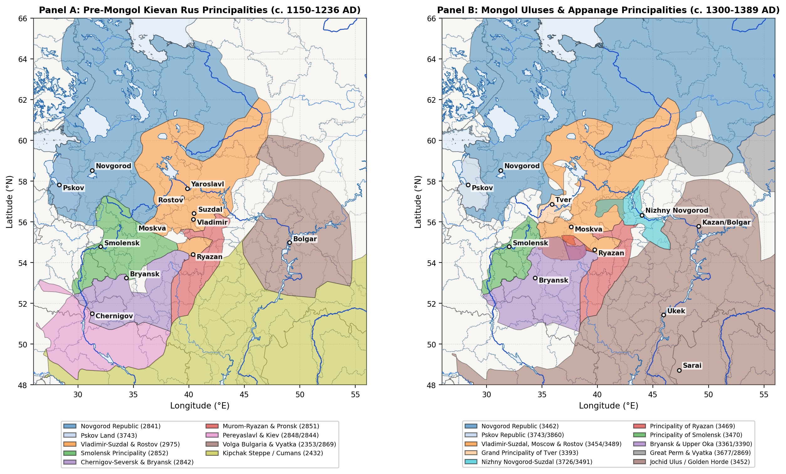
To maintain consistent geographic boundaries across the prehistoric, Kievan Rus (882 - 1240AD), Mongol/Appanage (1240 - 1500AD), Muscovite (1500 - 1700AD), and Imperial (1700 - 1900AD) periods, the principalities documented in saves/atlas_defacto.naissance are grouped into eight regional clusters defined by river basins and historical provincial boundaries (Table 1 and Figure 2). Because several large polities span multiple modern republics or oblasts - notably the Golden Horde (3452), the Novgorod Republic (2841, 3462), and Chernigov-Seversk (2842) - the estimates in this study cover the territory of the Russian Core and the Middle Volga-Ural basin (~1 943 000 km²), excluding the Lower Volga steppe south of Ukek (51,5°N), the Ukrainian Dnieper-Desna left bank south of the Seym-Bryansk watershed (52,0°N), and Belarusian Polotsk-Turov-Vitebsk west of the Smolensk Dnieper gate (31,0°E).
| Principality Cluster | Polity IDs (atlas_defacto) | Kievan Span | Mongol / Appanage | Corresponding Imperial Provinces & Area |
|---|---|---|---|---|
| 1. Novgorod, Pskov, St. Petersburg & N. Dvina | 2700, 2841, 3462, 3473 (Novgorod); 3743, 3860 (Pskov) | 882 - 1240AD | 1240 - 1478/1510AD | St. Petersburg, Novgorod, Pskov, Olonets, Arkhangelsk (680 000 km²) |
| 2. Vladimir-Suzdal, Rostov-Yaroslavl & Beloozero | 2975, 3454 (Vladimir-Suzdal); 3455, 3489 (Rostov); 3744, 3853 (Beloozero) | 988 - 1238AD | 1238 - 1474AD | Vladimir, Yaroslavl, Kostroma, Vologda (285 000 km²) |
| 3. Moscow & Tver | 3454, 3488, 3926 (Moscow); 3393, 3861 (Tver) | 1147 - 1238AD | 1247 - 1485AD | Moscow, Tver (92 000 km²) |
| 4. Ryazan, Murom, Pronsk & Upper Don | 2851, 3469, 3859 (Murom-Ryazan, Pronsk, Yelets, Lipetsk) | 1097 - 1237AD | 1237 - 1521AD | Ryazan, N. Tambov, N. Voronezh / Upper Don (105 000 km²) |
| 5. Smolensk, Toropets & Upper Dnieper | 2852, 3470 (Smolensk, Toropets, Vyazma, Dorogobuzh, Mstislavl) | 1054 - 1239AD | 1239 - 1404/1514AD | Smolensk, E. Toropets / Bely (78 000 km²) |
| 6. Chernigov-Bryansk, Kursk & Upper Oka | 2842 (Chernigov-Kursk); 3361 (Bryansk); 3390, 3855, 3856, 3857, 3858 (Upper Oka) | 1024 - 1239AD | 1239 - 1503AD | Kursk, Orel, Tula, Kaluga, Bryansk (108 000 km²) |
| 7. Nizhny Novgorod, Vyatka & Great Perm | 3726, 3491 (Nizhny Novgorod-Gorodets); 2869 (Vyatka); 3677 (Great Perm) | 1152 - 1239AD | 1239 - 1489/1505AD | Nizhny Novgorod, Vyatka, Perm (420 000 km²) |
| 8. Middle Volga (Bulgar, Kazan, Mukhshi, Kasimov) | 2353 (Volga Bulgaria); 3452 (Bulgar/Mukhshi Ulus); 3839 (Kazan); 3875 (Kasimov) | 922 - 1236AD | 1236 - 1552AD | Kazan, Simbirsk, Penza, Kasimov/Temnikov (175 000 km²) |
Prehistoric and Early Iron Age Settlement (10000BC - 850AD)
Mesolithic and Pit-Comb Neolithic Foragers and Fishers
Human recolonisation of the East European forest zone began during the Younger Dryas-Preboreal transition (10000 - 8000BC) as mobile reindeer- and elk-hunting bands followed periglacial river valleys northward [4][5]. Across the Volga-Oka interfluve (Clusters 2, 3, and 4) and the Upper Dnieper-Desna basin (Clusters 5 and 6), the Butovo and Resseta tanged-point cultures (8000 - 5500BC) established seasonal base camps on sandy lacustrine terraces and peat bogs such as Stanovoye 4, Ivanovskoye 7, and Zamostje 2 [5][6]. In the north-western lake basins (Cluster 1: Lake Ilmen, Lacha, Vozhe, Kubenskoye, and Sukhona), Kunda and Veretye forager-fishers occupied log-built shoreline settlements such as Nizhneye Veretye I (6800 - 6000BC), where waterlogged organic preservation reveals specialised bone harpoons, weir traps, and birch-bark floats [4]. Because Mesolithic subsistence depended on seasonal ungulate migrations and lacustrine fish runs, regional population densities remained low (0,006 - 0,025 persons/km²), with the entire Russian Core and Middle Volga-Ural territory increasing from roughly 13,0k inhabitants in 10000BC to 44,5k by 6000BC [6].
During the Atlantic climatic optimum (5500 - 2800BC), the spread of Upper Volga early ceramic traditions (5500 - 4200BC), the Lyalovo pit-comb ware culture (4200 - 3000BC), and the Eneolithic Volosovo culture (3200 - 2000BC) supported a much denser network of semi-sedentary fishing and hunting villages along lake outlets across the Volga-Oka, Klyazma, and Kama basins [7][8]. At the Sakhtysh I-VIII peat-bog complex near Ivanovo (Cluster 2) and multi-layer sites on lakes Nero and Pleshcheyevo, Volosovo communities constructed rectangular semi-subterranean timber longhouses measuring 60 - 200 m² with 3 - 6 axial hearths, each accommodating an extended household of 15 - 40 persons, alongside structured cemeteries exceeding 100 burials [7][8][10]. Across all eight regional clusters, the total population rose from 86,0k in 4000BC to 122,0k by 3000BC.
Bronze Age Agro-Pastoralists and Iron Age Hillfort Networks
Around 2800 - 2000BC, the arrival of Corded Ware groups of the Fatyanovo-Balanovo culture introduced domesticated cattle, sheep, goats, pigs, and wheeled vehicles into the Upper and Middle Volga forest zone [9][10]. Ancient DNA analyses from Fatyanovo cemeteries in Yaroslavl, Ivanovo, Moscow, and Chuvashia (including Volosovo-Danilovsky, featuring over 100 graves) confirm that Fatyanovo pastoralists carried steppe-derived ancestry mixed with Central European Early Farmers and coexisted for several centuries with indigenous Volosovo hunter-fishers before genetic and cultural integration [9][10]. Subsequent Middle and Late Bronze Age societies - the Abashevo (2200 - 1700BC), Seima-Turbino (2100 - 1800BC), Pozdnyakovo (1800 - 1200BC), and Prikazan (1600 - 900BC) cultures - expanded copper-tin metallurgy along the Oka, Klyazma, Kostroma, and Kama rivers, as documented at the Starshe-Nikitinsky cemetery and the Govyadinovo settlement [11][46]. Total regional population reached 182,0k in 2000BC and 278,0k by 1000BC.
The transition to the Early Iron Age (800BC - 500AD) brought local bog-iron smelting, stockbreeding (dominated by horses, cattle, and pigs), and forest swidden millet-barley cultivation [12][13][14]. Across the Upper Volga, Moskva, and Oka basins (Clusters 2 and 3), the Finno-Ugric Dyakovo culture (700BC - 500AD) constructed hundreds of promontory hillforts (gorodishcha) protected by concentric ditches and log palisades, while the related Gorodets culture occupied the Middle Oka and Moksha-Sura forest-steppe (Cluster 4), the Dnieper-Dvina and Yukhnovo cultures occupied the Smolensk and Bryansk-Desna basins (Clusters 5 and 6), and the Ananyino (800 - 300BC), Pyanobor (200BC - 300AD), and Glyadenovo cultures flourished along the Kama and Vyatka valleys (Clusters 7 and 8) [12][47]. N. A. Krenke's excavations at Dyakovo Gorodishche, Kuntsevo, and Borsheva in the Moskva basin show that Iron Age hillforts averaged 0,15 - 0,50 ha of enclosed habitation, spaced at 3 - 7 km intervals along main rivers and housing 50 - 150 inhabitants (8 - 20 timber dwellings), surrounded by small satellite hamlets (selishcha) [12][13][48]. By 1AD, the total population of the eight clusters reached 610,0k, expanding to 920,0k in 500AD and 1 390,0k by 800AD as Early Slavic groups (Ilmen Slovenes, Krivichi, Vyatichi, and Severians) and Early Bulgars entered the forest and forest-steppe zones [49][50].
Kievan Rus Principalities (850 - 1240AD)
Novgorod and Pskov
Between the ninth and eleventh centuries, the north-western lake basin (Cluster 1, polity IDs 2700, 2841, 3743) developed around the Baltic-Volga and "Varangians to the Greeks" river trade corridors [23][49]. Early proto-urban trading and craft centres at Staraya Ladoga (c. 753AD), Rurikovo Gorodishche at the source of the Volkhov (9th - 10th c., covering 4 - 7 ha), and the sopki high-mound cemetery network around the Lake Ilmen Poozerye gave rise by the mid-tenth century to the three initial urban nuclei (kontsy: Nerevsky, Slavensky, and Lyudin) of Veliky Novgorod [18][23]. By 1200AD, the outer ramparts (Okolny Gorod) of Veliky Novgorod enclosed roughly 240 ha, containing 4 000 - 5 000 fenced courtyard homesteads (usadby of 600 - 1 200 m² excavated at the Troitsky and Nerevsky trenches) and supporting an urban population of 25,0k - 30,0k [2][15][18].
In the western Lake Peipus-Velikaya basin, Pskov (3743) expanded from its 3,0 ha Krom promontory fortress (8th - 10th c.) across the Dovmontov Gorod and Middle/Outer Town ramparts (~105 ha by the fourteenth century) to 12,0k - 16,0k inhabitants, complemented by Izborsk, Ostrov, Opochka, and Gdov [51][52]. Other major eleventh- and twelfth-century Novgorodian towns included Staraya Russa (8,0k - 10,0k, a major salt-boiling centre south of Lake Ilmen), Torzhok (5,0k - 7,0k on the Tvertsa portage), Ladoga (3,0k - 4,0k), Velikiye Luki, and Koporye [2]. Across the agricultural core of the Five Pyatinas (Vodskaya, Obonezhskaya, Bezhetskaya, Derevskaya, and Shelonskaya) and the Northern Dvina Zavolochye fur-trapping colonies, the total population of the Novgorod-Pskov cluster rose from 285,0k in 900AD to 380,0k in 1000AD and 620,0k on the eve of the Mongol invasion (1200AD) [32].
Vladimir-Suzdal, Rostov-Yaroslavl, and Beloozero
In North-Eastern Rus (Cluster 2, polity IDs 2975, 3454, 3455, 3744), Slavic agricultural colonisation by Krivichi and Ilmen Slovene settlers merged with the indigenous Finno-Ugric Merya and Ves populations between the tenth and twelfth centuries [22][53][54]. The demographic heartland of the principality was the Suzdal Opolye (~4 500 km² of fertile, well-drained dark carbonate loess-like soils between Suzdal, Vladimir, Yuriev-Polsky, and Pereyaslavl-Zalessky). Over twenty years of systematic field surveys and geophysical magnetometry led by N. A. Makarov, I. N. Modin, and S. V. Shpolyanskiy have documented nearly 400 medieval rural settlements (selishcha) in the Opolye alone [20][21]. Roughly 25 - 30% of twelfth- and early thirteenth-century Opolye villages (such as Shekshovo-2/9, Gnezdilovo, Kideksha, and Ves) were large multi-homestead settlements covering 5 - 19 ha (100 - 350 inhabitants each), yielding local rural densities of 18,0 - 28,0 persons/km² within the Opolye loess islands [20][21].
Under Princes Yuri Dolgoruky (1125 - 1157), Andrey Bogolyubsky (1157 - 1174), and Vsevolod the Big Nest (1176 - 1212), a dense urban hierarchy took shape across the Klyazma-Upper Volga basin [54][55]. By 1200 - 1236AD, the fortified capital of Vladimir-on-Klyazma enclosed 145 ha across its Pecherny Gorod, Novy Gorod, and Vetchany Gorod ramparts, housing 20,0k - 25,0k inhabitants; Rostov Veliky (65 ha), Suzdal (49 ha), and Pereyaslavl-Zalessky (42 ha) each supported 8,0k - 12,0k residents; and Yaroslavl, Yuriev-Polsky, Kostroma, Galich-Mersky, Starodub-on-Klyazma, Gorodets-Radilov (60 ha), Uglich, and Dmitrov housed 3,0k - 7,0k each [2][16][56]. Further north along Lake Beloye and the Sheksna River (3744), the town of Beloozero (Kema/Krokhino and the fourteenth-century Belozersk ramparts) anchored a network of Finno-Slavic settlements documented by A. V. Kudryashov [57]. In total, Cluster 2 expanded from 310,0k in 900AD and 430,0k in 1000AD to 920,0k by 1200AD [56].
Smolensk, Chernigov-Bryansk, the Upper Oka, and Murom-Ryazan
Along the Upper Dnieper and Western Dvina portages (Cluster 5, polity ID 2852), tenth-century urbanism centred on the Gnezdovo archaeological complex (12 km west of Smolensk), comprising two fortified settlements (17 - 20 ha of habitation) and over 4 500 barrows (kurgany), with an estimated population of 1,5k - 2,5k permanent Scandinavian, Slavic, and Baltic residents [58][59]. In the eleventh and twelfth centuries, princely administration shifted to Smolensk, whose 115 ha fortified enclosure and dense posad artisan quarters along the Dnieper supported 20,0k - 30,0k inhabitants on the eve of the 1230 famine and pestilence chronicle entry, supplemented by Toropets, Roslavl, Mstislavl, Dorogobuzh, Vyazma, and Yelnya [2][15][60]. Across its 56 tributary pogosty recorded in the 1136 Statutory Charter of Prince Rostislav Mstislavich, the Smolensk principality grew from 210,0k in 1000AD to 430,0k in 1200AD [60].
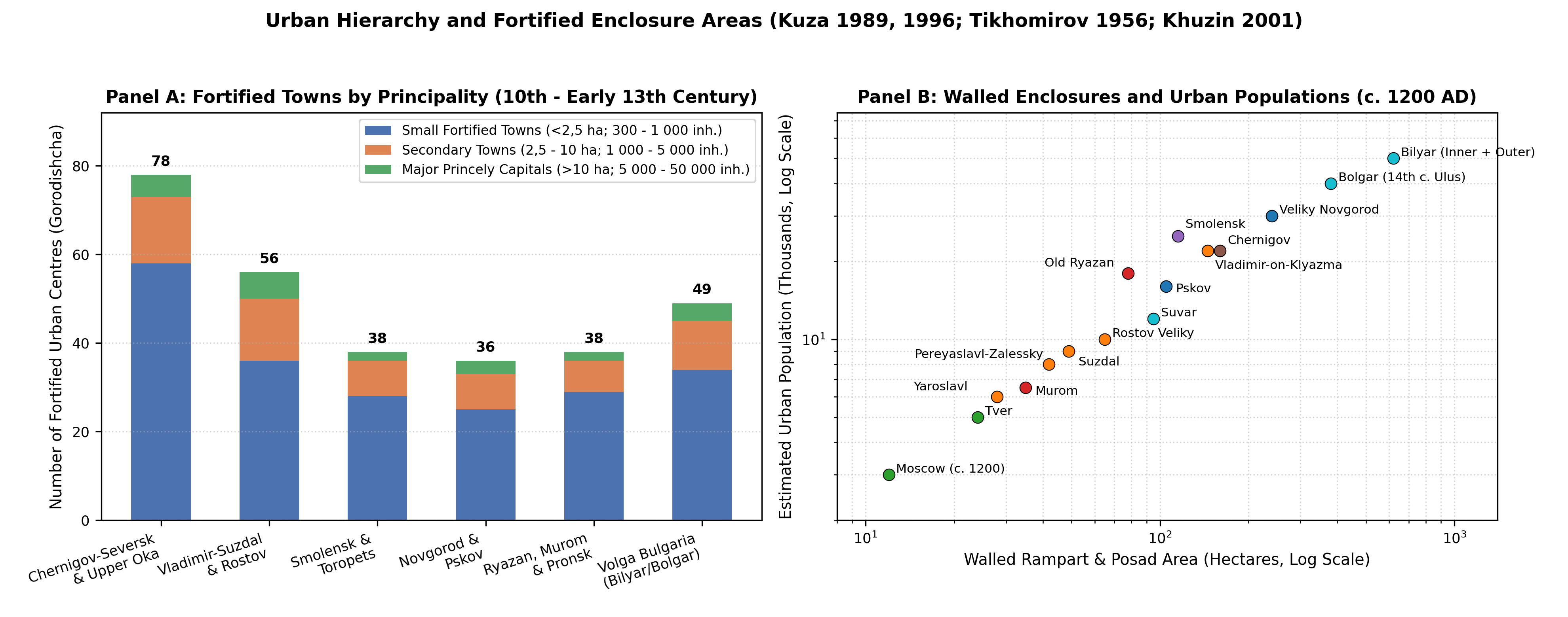
South and east of Smolensk, the Russian sector of the Chernigov-Seversk and Upper Oka lands (Cluster 6, polity IDs 2842, 3361, 3390) encompassed the Vyatichi tribal territory along the Upper Oka, Zhizdra, Upa, and Zusha rivers together with the Desna-Bryansk and Posemye (Kursk-Rylsk) basins [50][61]. As shown in Figure 3 (Panel A), A. V. Kuza's survey of 10th - 13th century fortified settlements (gorodishcha) demonstrates that the Chernigov-Seversk and Upper Oka region possessed one of the densest networks of small fortified administrative and refuge towns (<2,5 ha) in Rus, including Kozelsk, Karachev, Bryansk (Debryansk), Mtsensk, Novosil, Tarusa, Vorotynsk, Odoev, Belyov, Mezetsk, Mosalsk, Serensk (famous for its twelfth-century jewellery moulds), Dedoslavl, Spaš-Gorodok, and Kursk [2][16][61]. Combined with the major urban centres of the Desna-Seym basin, the Russian sector of Cluster 6 rose from 310,0k in 1000AD to 580,0k in 1200AD.
In the Middle Oka and Upper Don forest-steppe (Cluster 4, polity ID 2851), the Murom-Ryazan and Pronsk principalities expanded rapidly during the twelfth century [17]. Excavations by V. P. Darkevich and G. V. Borisevich at Old Ryazan (Staraya Ryazan, near Spassk-Ryazansky) show that its Northern (8 ha), Southern (60 ha), and suburban posad enclosures (~78 ha total) contained 1 500 - 2 500 timber homesteads and master craft workshops, supporting 15,0k - 20,0k inhabitants before its destruction by Batu Khan in December 1237 [2][17]. Along with Murom (35 ha, 6,0k - 8,0k), Pronsk (4,0k - 6,0k), Pereyaslavl-Ryazansky, Kolomna, Rostislavl, and Belgorod-Ryazansky, and over 250 twelfth- to fourteenth-century rural selishcha surveyed along the Upper Don and Nepryadva rivers [26], Cluster 4 reached 520,0k inhabitants by 1200AD (Table 2).
| Urban Centre | Cluster (Polity ID) | Walled & Posad Area (ha) | Estimated Homesteads | Calibrated Population |
|---|---|---|---|---|
| Bilyar (Volga Bulgaria) | Cluster 8 (2353) | 620 (800 w/ suburbs) | 7 500 - 9 500 | 45,0k - 60,0k (c. 1200) |
| Bolgar (Golden Horde Ulus) | Cluster 8 (3452) | 380 (14th c. rampart) | 5 500 - 7 000 | 35,0k - 45,0k (c. 1340) |
| Veliky Novgorod | Cluster 1 (2841) | 240 (Okolny Gorod) | 4 200 - 5 000 | 25,0k - 30,0k (c. 1200) |
| Smolensk | Cluster 5 (2852) | 115 (Detinets + Posad) | 3 500 - 4 500 | 22,0k - 28,0k (c. 1200) |
| Vladimir-on-Klyazma | Cluster 2 (2975) | 145 (3 rampart rings) | 3 200 - 4 000 | 20,0k - 25,0k (c. 1200) |
| Chernigov (Desna Core) | Cluster 6 (2842) | 160 (Detinets + Okolny) | 3 200 - 4 000 | 20,0k - 25,0k (c. 1200) |
| Old Ryazan (Staraya Ryazan) | Cluster 4 (2851) | 78 (North + South + Posad) | 2 200 - 3 000 | 15,0k - 20,0k (c. 1236) |
| Pskov | Cluster 1 (3743) | 105 (Krom + Outer Wall) | 2 200 - 2 800 | 14,0k - 18,0k (c. 1350) |
| Suvar (Volga Bulgaria) | Cluster 8 (2353) | 95 (Walled Shahristan) | 1 800 - 2 200 | 10,0k - 14,0k (c. 1200) |
| Rostov Veliky | Cluster 2 (2975) | 65 (Rampart enclosure) | 1 500 - 1 900 | 9,0k - 12,0k (c. 1200) |
| Suzdal | Cluster 2 (2975) | 49 (Kremlin + Okolny) | 1 300 - 1 600 | 8,0k - 10,0k (c. 1200) |
| Pereyaslavl-Zalessky | Cluster 2 (2975) | 42 (1152 Earth Rampart) | 1 100 - 1 400 | 7,0k - 9,0k (c. 1200) |
| Staraya Russa | Cluster 1 (2841) | 38 (Saline Posad) | 1 200 - 1 500 | 8,0k - 10,0k (c. 1200) |
| Murom | Cluster 4 (2851) | 35 (Kremlin + Posad) | 950 - 1 200 | 6,0k - 7,5k (c. 1200) |
| Yaroslavl | Cluster 2 (2975) | 28 (13th c. Ramparts) | 850 - 1 100 | 5,0k - 7,0k (c. 1200) |
| Tver | Cluster 3 (3393) | 24 (1200) / 85 (1400) | 750 / 2 200 | 4,5k (1200) / 14,0k (1400) |
| Moscow (1200 / 1450AD) | Cluster 3 (3454) | 12 (1200) / 190 (1450) | 450 / 6 500 | 3,0k (1200) / 40,0k (1450) |
Mongol Census, Appanages, and Volga Khanates (1240 - 1500AD)
The 1237-1240 Invasion, the 1257-1259 Census, and Appanage Settlement
Batu Khan's winter campaign of 1237 - 1238 against Ryazan, Kolomna, Moscow, Vladimir, Suzdal, Rostov, Yaroslavl, Tver, Torzhok, and Kozelsk - preceded by Subutai's 1236 conquest of Volga Bulgaria and followed by the 1239 campaigns against Murom, Gorodets, and Chernigov - inflicted severe demographic losses on the fortified urban centres and exposed forest-steppe valleys [31][62][63]. Out of 74 Russian towns known from twelfth- and early thirteenth-century archaeological layers, 49 were burned during 1237 - 1240, and 14 (including Old Ryazan and Izheslavl) never recovered their prior urban status [2][17]. Between 1200 and 1250AD, total population across the eight clusters fell by roughly 18%, from 4 670,0k to 3 850,0k, with the steepest declines occurring in Ryazan (-28,8%), Chernigov-Upper Oka (-25,9%), Volga Bulgaria (-22,4%), and Vladimir-Suzdal (-19,6%), whereas uninvaded Novgorod and Pskov experienced only minor border losses (-4,8%) [56][62].
To organise systematic taxation (vykhod / dan') and military conscription across the Jochid Ulus, Grand Qan Möngke and Berke dispatched imperial census officials (chislenniki) in 1257 - 1259 to register households in Suzdalia, Ryazan, Murom, and (with Alexander Nevsky's military enforcement in 1259) Veliky Novgorod [3][29][31]. As analysed by G. Vernadsky [30] and T. T. Allsen [29], the Mongol administrative system grouped registered tax-paying peasant households into decimal units of ten, hundred, thousand (tysyacha), and ten thousand (tumen / t'ma). The 27 to 43 t'my (tymy) cited in fourteenth-century princely treaties and chronicle entries across North-Eastern Rus and Novgorod - where a fiscal t'ma in wooded agricultural zones corresponded to 10 000 - 15 000 tax-paying households (60,0k - 90,0k inhabitants) rather than a full steppe cavalry corps - align closely with an aggregate post-invasion population of 3,85M in 1250AD, recovering to 4,33M in 1300AD and 4,84M on the eve of the Black Death (1350AD) [29][30][54].
Between the late thirteenth and fifteenth centuries, archaeological surveys document a profound reorganisation of rural settlement across the Moscow, Tver, and Vladimir-Suzdal principalities (Clusters 2 and 3) known in Russian historiography as the "ascent to the hills" (vzlet na kholmy) or internal watershed colonisation [21][24][25]. Rather than remaining concentrated along major river floodplains vulnerable to Golden Horde punitive raids (rati such as Dyuden's campaign of 1293 or Tokhtamysh's sack of 1382), peasant settlers cleared upland morainic loams using iron-shod sokha ploughs and three-field crop rotation (winter rye, spring oats, and fallow). S. Z. Chernov's total archaeological surveys of the Radonezh, Zvenigorod, Vorya, and Pereyaslavl volosti demonstrate that between 1280 and 1450AD hundreds of small 1 - 3 household clearing hamlets (pochinki and derevni, 0,2 - 0,8 ha) multiplied across interfluvial hills under the patronage of the Grand Princes of Moscow (3454, 3488) and monastic estates such as the Trinity-Sergius Lavra [24][25]. Simultaneously, the Grand Principality of Tver (3393, including Kashin, Mikulin, Zubtsov, Kholm, and Staritsa) and the Principality of Nizhny Novgorod-Suzdal (3726, 3491, founded 1341 at the Volga-Oka confluence) emerged as major demographic and commercial rivals to Moscow [54][64]. Although the second wave of the Black Death (1352 - 1353, which killed Grand Prince Simeon the Proud and Metropolitan Theognostus, followed by recurrent plague outbreaks in 1364 - 1366, 1389, and 1417 - 1427) temporarily reduced total population from 4 840,0k in 1350AD to 4 490,0k in 1400AD, rapid upland colonisation raised the Moscow-Tver cluster (Cluster 3) from 330,0k in 1250 to 830,0k in 1450 and 1 080,0k by 1500AD [33][65].
Volga Bulgaria, the Golden Horde Uluses, and the Kazan, Kasimov, and Temnikov Polities
In the Middle Volga-Kama basin (Cluster 8, polity IDs 2353, 3452, 3839, 3875), pre-Mongol Volga Bulgaria (922 - 1236AD) was one of the most urbanised states in Eastern Europe [19][27]. F. Sh. Khuzin's and K. A. Rudenko's syntheses of over 170 Bulgar fortified towns (gorodishcha) and >700 unfortified villages (selishcha) show that the twelfth-century capital of Bilyar (Velikiy Gorod in Russian chronicles) encompassed 620 ha inside its triple earthen ramparts (800 ha including outer suburbs), with brick-heated residences, glass and metallurgical workshops, and a peak population of 45,0k - 60,0k [19][27]. Other major Bulgar towns included Suvar (95 ha, 10,0k - 14,0k), Bolgar (25 - 30 ha in the twelfth century), Oshel, Juketau (Zhukotin), Kashan, Muromsky Gorodok (150 ha on the Samara Bend), and Kazan (founded c. 1005) [19]. Across the fertile chernozem plains of Western Trans-Kama (Zakamye: the Cheremshan,Sheshma, Aktay, and Maly Cheremshan valleys), pre-Mongol Volga Bulgaria supported 850,0k inhabitants by 1200AD [27].
After the 1236 Mongol conquest destroyed Bilyar, Oshel, and Suvar, the region was reorganised as the Bulgar Ulus and the southern Ulus of Mukhshi (Narovchat) within the Golden Horde (3452) [28][66][67]. Under Mengu-Timur and Uzbeg Khan (1313 - 1341), Bolgar expanded into a 380 ha walled metropolis (35,0k - 45,0k inhabitants) serving as the northern summer residence and mint of the Jochid khans [28], while in the Moksha-Sura forest-steppe (modern Penza Oblast and Mordovia) the city of Mukhshi (Narovchat) (>150 ha, with brick mosques, mausoleums, baths, and a silver mint established in 1313) anchored a dense network of Mordvin, Burtas, and Tatar settlements [66][67]. East of the Kama in the Ik-Belaya interfluve, Tatar-Muslim agricultural and pastoral communities also expanded during the thirteenth and fourteenth centuries [68].
However, the Golden Horde's "Great Troubles" (Velikaya Zamknutnya, 1359 - 1380), Bulat-Timur's 1361 seizure of Bolgar, Muscovite river raids (1376, 1399), Timur's (Tamerlane's) 1395 campaign, and nomadic Nogai incursions triggered a decisive northward migration from the exposed Southern Zakamye steppe borderland into the forested Predkamye (north of the Kama: the Kazanka, Mesha, Ashit, Ilet, and Sviyaga basins) [27][34]. This demographic shift laid the foundation of the Khanate of Kazan (3839, 1438 - 1552AD), administered through five territorial darugas (Alat, Arsk, Galich, Zyuri, and Nogai) and populated by Kazan Tatars, Chuvash, Mari (Cheremis), Udmurts (Votyaks), and Mordvins (860,0k across Cluster 8 in 1500AD) [34][69]. On the Oka-Moksha frontier between Ryazan and Kazan, the Kasimov Khanate (3875, founded c. 1452 at Gorodets-Meshchersky) and the Temnikov Principality (ruled by Tatar princes of the Bekhanid line over Mordvin belyaki tribute districts) formed a densely settled military buffer zone documented in sixteenth- and seventeenth-century service registers [70][71]. Meanwhile, along the Vyatka and Upper Kama rivers (Cluster 7), Russian colonists from Novgorod, Ustyug, and Galich established the autonomous Vyatka Land (2869, centred on Khlynov, Kotelnich, and Orlov, together with the Arsk/Karino Tatar princes settled along the Cheptsa River; annexed by Ivan III in 1489) and the Principality of Great Perm (3677, centred on Cherdyn, Pokcha, and Iskor on the Kolva-Vishera-Kama confluence, arising from the medieval Komi-Permyak Lomovatovo and Rodanovo cultures; subordinated in 1472 - 1505) [47][72][73][74][75].
Muscovite Cadastral Registers and the 1678 Household Census (1500 - 1700AD)
Following the unification of the northern principalities under Ivan III (1462 - 1505) and Vasily III (1505 - 1533), the Muscovite state compiled comprehensive land cadastres (pistsovye knigi) that provide household-by-household inventories of towns and rural pogosty [3][32][33]. In the Novgorod Five Pyatinas (1495 - 1505), A. L. Shapiro and A. I. Kopanev's analysis of surviving cadastral books documents approximately 65 000 - 70 000 peasant homesteads (dvory) assessed in obzha plough-units (1 obzha = 1 man with 1 horse ploughing ~15 desyatiny across three fields), corresponding to 500,0k - 550,0k inhabitants in the Five Pyatinas proper and 810,0k across the entire Novgorod-Pskov-Northern Dvina cluster (Cluster 1) in 1500AD, rising to 940,0k by 1550AD [32][33]. Across the Zamoskovny Krai (Clusters 2 and 3: Moscow, Tver, Vladimir, Suzdal, Pereyaslavl, Rostov, Yaroslavl, Kostroma, and Beloozero), early sixteenth-century cadastres indicate 2,57M inhabitants in 1500AD (1,49M in Cluster 2 and 1,08M in Cluster 3), expanding to 3,09M by mid-century (1550AD) as three-field arable farming reached its highest pre-industrial extent in the non-chernozem forest zone [1][33]. In the newly annexed Kazan uezd (Cluster 8), the 1565 - 1568 pistsovye knigi of Nikita Borisov and Dmitry Kikin register over 700 Russian, Tatar, and Chuvash settlements across the Kazanka, Sviyaga, and Kama darugas [34][69].
During the late sixteenth and early seventeenth centuries, the northern and western clusters suffered two severe demographic crises: first, the Livonian War (1558 - 1583), the Oprichnina (1565 - 1572, including Ivan IV's 1570 sack of Novgorod), and the 1569 - 1571 famine and plague, which left 60 - 85% of registered obzhi in the Novgorod Pyatinas and Moscow uezd recorded as abandoned waste (pustoshi) in the 1580s cadastres [32][76]; and second, the Time of Troubles (Smuta, 1598 - 1613), triggered by the 1601 - 1603 volcanic-winter famine and Polish-Lithuanian and Swedish military intervention [1][65]. Across all eight clusters, total population declined from 7 650,0k in 1550AD to 6 750,0k in 1600AD.
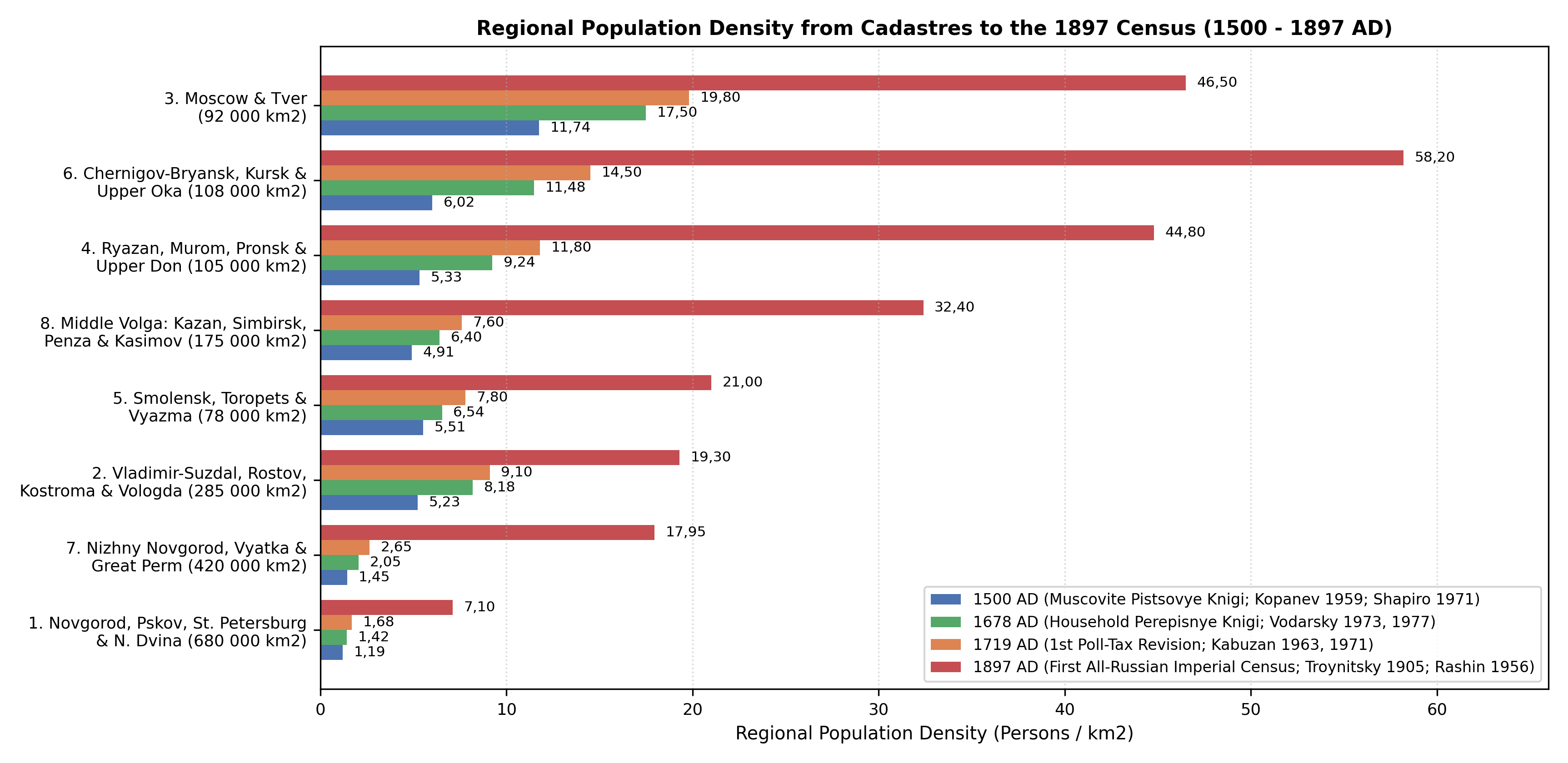
Recovery during the seventeenth century was accompanied by a decisive geographical redistribution of population southward across the Belgorod and Simbirsk Fortified Lines (Zasechnaya cherta, constructed 1635 - 1654), documented in the 1646 and 1678 Empire-wide household census books (perepisnye knigi) analysed by Ya. E. Vodarsky [1][3][35]. Because seventeenth-century peasant families frequently combined married brothers or adult sons inside a single fenced courtyard to reduce household (dvor) taxation, Vodarsky established that the average rural household size in 1678 had risen to 6,5 - 8,5 persons (3,5 - 4,2 males per dvor). As illustrated in Figure 4, between 1500 and 1678/1700AD population in the old north-western forest core (Cluster 1) barely surpassed its mid-sixteenth-century level (1 015,0k in 1700AD), whereas the forest-steppe provinces along the Upper Oka, Kursk, Orel, and Tula (Cluster 6, doubling from 650,0k in 1500 to 1 350,0k in 1700), the Ryazan and Upper Don black-earth frontier (Cluster 4, rising from 560,0k to 1 050,0k), the Middle Volga (Cluster 8, rising from 860,0k to 1 180,0k), and the Vyatka-Kama-Perm lands (Cluster 7, rising from 610,0k to 915,0k) expanded rapidly, bringing the aggregate population of the eight clusters to 10 190,0k (10,19M) by 1700AD [35].
Imperial Tax Revisions and the 1897 Census (1700 - 1900AD)
The transition from household taxation to the individual male soul tax (podushnaya podat') under Peter I (1718 - 1724) inaugurated a regular series of ten Imperial Poll-Tax Revisions (revizii / revizskie skazki) between 1719 and 1858, thoroughly compiled and cross-checked with parish vital registers by V. M. Kabuzan [36][37][38][39], followed by late nineteenth-century zemstvo statistics and the First All-Russian Imperial Census of 28 January 1897 [40][41][44]. Across the two centuries between 1700 and 1900AD, the total population of the eight historical clusters quadrupled from 10 190,0k (10,19M) to 41 500,0k (41,50M), driven by three major regional processes (Figure 5):
- The Rise of Saint Petersburg and the North-Western Provinces (
Cluster 1): Peter I's foundation of Saint Petersburg in the Neva delta (1703, within the historical Ingrian/Vodskaya Pyatina territory of Novgorod) created a rapidly growing imperial capital and maritime port that reached~95,0kinhabitants by1750,220,0kin1800,490,0kin1850, and1 264,9kin the1897Census (2 112,0kacross Saint Petersburg Guberniya) [40][44]. Combined with Novgorod (1 367,0kin1897), Pskov (1 122,3k), Olonets (364,2k), and the Northern Dvina / Arkhangelsk districts, Cluster 1 rose from1 015,0kin1700to1 950,0kin1800and4 950,0kby1900AD[37][44]. - Agrarian Expansion in the Central Black Earth (Chernozem) Belt (
Clusters 4 and 6): Throughout the eighteenth and first half of the nineteenth centuries (1stthrough10thRevisions,1719 - 1858), the fertile forest-steppe provinces south of the Oka River experienced the highest rural natural increase and peasant settlement densities in the Russian core [37][42][43]. InCluster 6(comprising Kursk Guberniya [2 371,1kin1897], Orel Guberniya with Bryansk and Karachev [2 033,8k], Tula Guberniya [1 419,5k], and Kaluga Guberniya [1 132,8k]), the regional population climbed from1 350,0kin1700to2 950,0kin1800and6 450,0kin1900AD(58,20persons/km² in1897) [40][44]. Similarly, inCluster 4(Ryazan Guberniya [1 802,2kin1897] and the northern Upper Don uezds of Tambov and Voronezh Guberniyas - Lipetsk, Yelets, Lebedyan, Dankov, Usman, Shatsk, and Morshansk), population rose from1 050,0kin1700to2 250,0kin1800and4 850,0kby1900AD[43][44]. - Industrialisation in the Central Industrial Region and Demographic Boom in the Volga-Ural Provinces (
Clusters 2, 3, 7, and 8): In the old Zamoskovny core (Clusters 2 and 3), thin podzolic soils encouraged seasonal craft migration (otkhodnichestvo), proto-industrial linen and cotton manufacturing (centred on Moscow, Ivanovo-Voznesensk, Shuia, Orekhovo-Zuyevo, Yaroslavl, and Kostroma), and post-1861 railway urbanisation [39][41]. By the1897Census, Moscow Guberniya reached2 430,6k(with Moscow city at1 038,6k) and Tver Guberniya reached1 769,1k, bringingCluster 3to4 420,0kin1900AD; simultaneously,Cluster 2- spanning Vladimir (1 515,7k), Kostroma (1 387,0k), Vologda (1 341,8k), and Yaroslavl (1 071,4k) together with the Belozersk and Cherepovets districts - reached5 650,0kby1900AD[40][44]. Even faster growth occurred inCluster 7(Nizhny Novgorod [1 524,9k], Vyatka [3 030,8k], and Perm [2 994,3k]), where state peasant land colonisation in Vyatka and the eighteenth- and nineteenth-century expansion of Ural iron and copper metallurgy multiplied the cluster's population more than eightfold from915,0kin1700to2 420,0kin1800and7 650,0kin1900AD[37][44]. In the Middle Volga (Cluster 8: Kazan Guberniya [2 170,7kin1897], Simbirsk [1 527,8k], Penza [1 470,5k], and the Kasimov, Elatma, and Temnikov uezds [~680,0k]), multi-ethnic Russian, Tatar, Chuvash, Mordvin, and Mari agricultural growth raised the population from1 180,0kin1700to2 470,0kin1800and5 850,0kin1900AD[44][45].
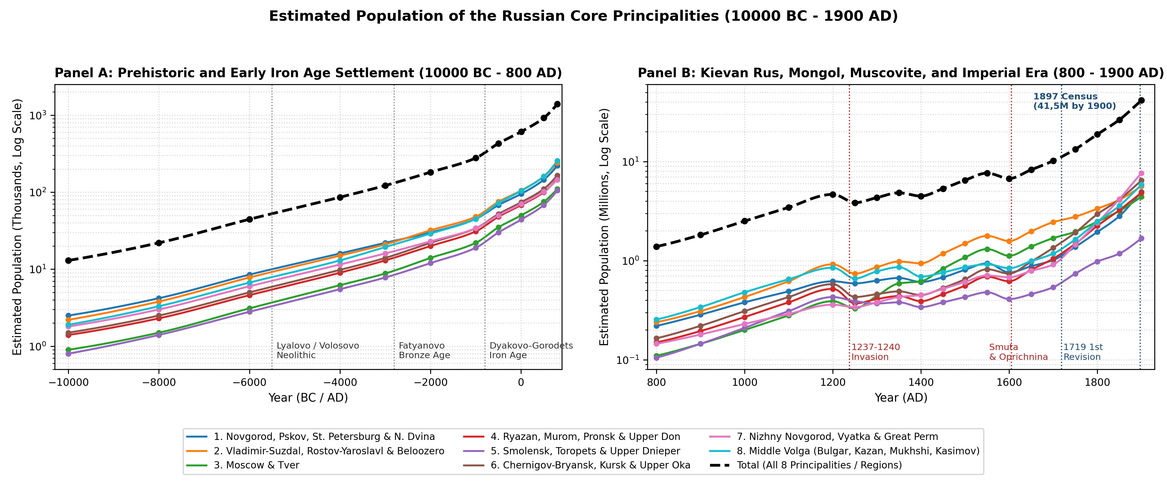
Appendix
Population Estimates by Principality (10000BC - 1900AD)
Table 3 presents the population estimates (in thousands k and millions M, formatted with European decimal commas) across all eight principality clusters from 10000BC to 1900AD.
| Year | 1. Novg/SPb | 2. Vlad-Suzd | 3. Mosc-Tver | 4. Ryaz-Don | 5. Smol. | 6. Oka-Kursk | 7. N.Nov-Perm | 8. Mid-Volga | Total |
|---|---|---|---|---|---|---|---|---|---|
| 10000BC | 2,5k | 2,2k | 0,9k | 1,4k | 0,8k | 1,5k | 1,8k | 1,9k | 13,0k |
| 8000BC | 4,2k | 3,8k | 1,5k | 2,3k | 1,4k | 2,5k | 3,0k | 3,3k | 22,0k |
| 6000BC | 8,5k | 7,8k | 3,1k | 4,6k | 2,8k | 5,0k | 6,0k | 6,7k | 44,5k |
| 4000BC | 16,0k | 15,0k | 6,2k | 9,0k | 5,5k | 9,8k | 11,5k | 13,0k | 86,0k |
| 3000BC | 22,0k | 21,0k | 8,8k | 13,0k | 7,8k | 14,0k | 16,0k | 19,4k | 122,0k |
| 2000BC | 30,0k | 32,0k | 14,0k | 20,0k | 12,0k | 22,0k | 23,0k | 29,0k | 182,0k |
| 1000BC | 45,0k | 48,0k | 22,0k | 31,0k | 19,0k | 34,0k | 34,0k | 45,0k | 278,0k |
| 500BC | 68,0k | 75,0k | 35,0k | 48,0k | 30,0k | 52,0k | 50,0k | 72,0k | 430,0k |
| 1AD | 95,0k | 105,0k | 50,0k | 68,0k | 44,0k | 74,0k | 70,0k | 104,0k | 610,0k |
| 500AD | 145,0k | 160,0k | 75,0k | 100,0k | 68,0k | 110,0k | 102,0k | 160,0k | 920,0k |
| 800AD | 220,0k | 240,0k | 110,0k | 150,0k | 105,0k | 165,0k | 145,0k | 255,0k | 1 390,0k |
| 900AD | 285,0k | 310,0k | 145,0k | 195,0k | 145,0k | 220,0k | 180,0k | 340,0k | 1 820,0k |
| 1000AD | 380,0k | 430,0k | 200,0k | 270,0k | 210,0k | 310,0k | 230,0k | 480,0k | 2 510,0k |
| 1100AD | 490,0k | 620,0k | 280,0k | 380,0k | 310,0k | 430,0k | 290,0k | 650,0k | 3 450,0k |
| 1200AD | 620,0k | 920,0k | 390,0k | 520,0k | 430,0k | 580,0k | 360,0k | 850,0k | 4 670,0k |
| 1250AD | 590,0k | 740,0k | 330,0k | 370,0k | 390,0k | 430,0k | 340,0k | 660,0k | 3 850,0k |
| 1300AD | 630,0k | 860,0k | 440,0k | 410,0k | 370,0k | 460,0k | 380,0k | 780,0k | 4 330,0k |
| 1350AD | 670,0k | 980,0k | 590,0k | 440,0k | 380,0k | 490,0k | 430,0k | 860,0k | 4 840,0k |
| 1400AD | 610,0k | 940,0k | 620,0k | 390,0k | 340,0k | 450,0k | 450,0k | 690,0k | 4 490,0k |
| 1450AD | 680,0k | 1 180,0k | 830,0k | 460,0k | 380,0k | 530,0k | 520,0k | 760,0k | 5 340,0k |
| 1500AD | 810,0k | 1 490,0k | 1 080,0k | 560,0k | 430,0k | 650,0k | 610,0k | 860,0k | 6 490,0k |
| 1550AD | 940,0k | 1 780,0k | 1 310,0k | 690,0k | 480,0k | 820,0k | 710,0k | 920,0k | 7 650,0k |
| 1600AD | 760,0k | 1 580,0k | 1 120,0k | 620,0k | 410,0k | 740,0k | 680,0k | 840,0k | 6 750,0k |
| 1650AD | 880,0k | 1 980,0k | 1 390,0k | 810,0k | 460,0k | 980,0k | 790,0k | 990,0k | 8 280,0k |
| 1700AD | 1 015,0k | 2 450,0k | 1 690,0k | 1 050,0k | 540,0k | 1 350,0k | 915,0k | 1 180,0k | 10 190,0k |
| 1750AD | 1 380,0k | 2 780,0k | 1 960,0k | 1 480,0k | 740,0k | 1 920,0k | 1 450,0k | 1 640,0k | 13 350,0k |
| 1800AD | 1 950,0k | 3 350,0k | 2 480,0k | 2 250,0k | 980,0k | 2 950,0k | 2 420,0k | 2 470,0k | 18 850,0k |
| 1850AD | 2 820,0k | 4 120,0k | 3 180,0k | 3 240,0k | 1 180,0k | 4 150,0k | 4 180,0k | 3 580,0k | 26 450,0k |
| 1900AD | 4 950,0k | 5 650,0k | 4 420,0k | 4 850,0k | 1 680,0k | 6 450,0k | 7 650,0k | 5 850,0k | 41 500,0k |
Appanage Population Estimates (1200 - 1450AD)
To map the eight regional clusters onto the individual fourteenth- and fifteenth-century appanage principalities (udelnye knyazhestva) and Golden Horde uluses recorded in saves/atlas_defacto.naissance, Table 4 provides population and density estimates at four medieval benchmarks (1200, 1300, 1380, and 1450AD).
| Appanage Principality / Ulus (atlas_defacto ID) | 1200AD | 1300AD | 1380AD | 1450AD | Core Density (inh./km², 1380) |
|---|---|---|---|---|---|
| Novgorod Republic (2841 / 3462) | 510,0k | 505,0k | 525,0k | 530,0k | 8,2 (Ilmen-Volkhov) |
| Pskov Republic (3743 / 3860) | 110,0k | 125,0k | 140,0k | 150,0k | 6,4 (Velikaya basin) |
| Vladimir, Pereyaslavl, Yuriev & Starodub (2975 / 3454) | 480,0k | 410,0k | 450,0k | 540,0k | 21,5 (Suzdal Opolye) |
| Rostov, Yaroslavl, Uglich, Mologa & Kostroma (3455 / 3489) | 330,0k | 325,0k | 375,0k | 460,0k | 9,8 (Rostov-Nero) |
| Beloozero & Vologda-Sheksna Appanages (3744 / 3853) | 110,0k | 125,0k | 145,0k | 180,0k | 2,4 (Sheksna-Beloye) |
| Grand Principality of Moscow, Mozhaysk, Vereya & Serpukhov (3454 / 3488) | 210,0k | 240,0k | 360,0k | 545,0k | 14,2 (Moskva-Radonezh) |
| Grand Principality of Tver, Kashin, Mikulin & Rzhev (3393 / 3861) | 180,0k | 200,0k | 245,0k | 285,0k | 11,0 (Upper Volga-Tvertsa) |
| Grand Principality of Ryazan, Pronsk & Yelets (2851 / 3469 / 3859) | 410,0k | 320,0k | 335,0k | 365,0k | 7,8 (Middle Oka-Pronya) |
| Principality of Murom & Meshchera (2851 / 3469) | 110,0k | 90,0k | 90,0k | 95,0k | 4,5 (Lower Oka) |
| Principality of Smolensk, Vyazma & Toropets (2852 / 3470) | 430,0k | 370,0k | 365,0k | 380,0k | 5,2 (Upper Dnieper) |
| Principality of Bryansk, Karachev & Kursk-Posemye (2842 / 3361) | 340,0k | 250,0k | 255,0k | 280,0k | 5,8 (Desna-Sudost) |
| Upper Oka Appanages: Novosils, Odoev, Vorotynsk, Belyov, Tarusa, Mezetsk (3390 / 3855-3858) | 240,0k | 210,0k | 225,0k | 250,0k | 7,5 (Upper Oka-Upa-Zusha) |
| Nizhny Novgorod-Suzdal & Gorodets Principality (3726 / 3491) | 190,0k | 205,0k | 235,0k | 270,0k | 8,4 (Volga-Oka confluence) |
| Vyatka Land (Khlynov, Kotelnich, Orlov, Karino) (2869) | 95,0k | 100,0k | 120,0k | 155,0k | 2,8 (Middle Vyatka) |
| Great Perm Principality (Cherdyn, Pokcha, Upper Kama) (3677) | 75,0k | 75,0k | 85,0k | 95,0k | 1,1 (Upper Kama-Vishera) |
| Volga Bulgaria / Bulgar Ulus / Kazan Khanate (2353 / 3452 / 3839) | 680,0k | 560,0k | 570,0k | 580,0k | 14,5 (Bolgar-Kazan core) |
| Ulus of Mukhshi (Narovchat), Kasimov & Temnikov Principality (3452 / 3875) | 170,0k | 220,0k | 220,0k | 180,0k | 6,2 (Moksha-Tsna-Oka) |
Regional Density Estimates
Table 5 summarises the localised agro-ecological and urban settlement zones across the Russian Core and Middle Volga-Ural region from 10000BC to 1900AD, together with their calibrated population densities and empirical sources.
| Regional Zone Key | Date Range | Density (inh./km²) | Area (km²) | Ecological Zone & Historical / Archaeological Basis |
|---|---|---|---|---|
| butovo_veretye_mesolithic | -10000 to -5500 | 0,012 | 180,0k | Lacha-Vozhe-Sukhona & Volga-Oka peat-bog lacustrine necks (Nizhneye Veretye I, Stanovoye 4; Oshibkina 2006; Zhilin 2019, 2022) |
| lyalovo_volosovo_pit_comb | -5500 to -2500 | 0,065 | 240,0k | Upper/Middle Volga, Oka, Klyazma & Kama multi-hearth longhouse villages (60-200 m², 15-40 persons/house; Sakhtysh I-VIII; Kostyleva et al. 2014, 2022) |
| fatyanovo_abashevo_bronze | -2800 to -1500 | 0,180 | 310,0k | Upper Volga-Moskva-Oka-Sura-Sviyaga pastoralist clan territories (>300 cemeteries led by Volosovo-Danilovsky; Nordqvist & Heyd 2020; Saag et al. 2021) |
| dyakovo_gorodets_iron_age | -800 to 750 | 0,550 | 420,0k | Moskva, Upper Volga, Oka, Desna & Kama bluff hillfort corridors (0,15-0,50 ha gorodishcha every 3-7 km, 50-150 persons/fort; Krenke 2011; Lopatina 2023) |
| ilmen_volkhov_poozerye_core | 800 to 1900 | 14,000 | 6,5k | Lake Ilmen Poozerye, upper Volkhov (Rurikovo Gorodishche, Veliky Novgorod) & lower Shelona/Msta/Lovat pogost core (Nosov 1990; Shapiro et al. 1971) |
| suzdal_opolye_chernozem_core | 1050 to 1900 | 23,000 | 4,5k | Suzdal-Yuriev-Pereyaslavl-Vladimir dark-soil Opolye loess islands (~400 medieval selishcha, 25-30% covering 5-19 ha; Modin et al. 2020; Shpolyanskiy 2021) |
| moscow_tver_watershed_hills | 1280 to 1900 | 18,500 | 18,0k | Moscow-Radonezh-Zvenigorod-Dmitrov-Tver morainic watershed hills (three-field hamlet colonisation & Zamoskovny cadastres; Chernov 1991; Boytsov et al. 2020) |
| upper_don_kulikovo_forest_steppe | 1150 to 1900 | 44,800 | 105,0k | Ryazan, Pronsk & Upper Don forest-steppe (medieval selishcha followed by 1719-1897 Tambov/Voronezh/Ryazan agrarian boom; Vorotyntsev 2016; Myakisheva 2018) |
| bilyar_bolgar_cheremshan_core | 950 to 1400 | 18,000 | 16,5k | Western Zakamye (Bilyar 800 ha, Bolgar 380 ha, Suvar 95 ha, Cheremshan-Aktay chernozem agricultural heartland; Khuzin 2001; Rudenko 2012, 2018) |
| kazan_predkamye_daruga_core | 1380 to 1900 | 32,400 | 175,0k | Middle Volga (Kazan, Simbirsk, Penza & Kasimov/Temnikov from 1565-1568 cadastres to 1897 Census; Mustafina 2008; Abdullin et al. 2013; Troynitsky 1905) |
| central_black_earth_1897_belt | 1719 to 1900 | 58,200 | 108,0k | Kursk, Orel, Tula & Kaluga forest-steppe and chernozem guberniyas from the 1st-10th Revisions to the 1897 Census (Kabuzan 1971; Rashin 1956; Troynitsky 1905) |
| moscow_st_petersburg_industrial_1897 | 1861 to 1900 | 68,500 | 65,0k | Moscow & Saint Petersburg metropolitan industrial districts in the 1897 First All-Russian Imperial Census (Troitskaya & Ulyanova 2017; Rashin 1956; Troynitsky 1905) |
Sources
1.Vodarsky, Yaroslav Yevgenyevich. Naseleniye Rossii za 400 let (XVI - nachalo XX vv.) [The Population of Russia over 400 Years]. Prosveshcheniye, 1973.
2.Kuza, Andrey Vasilyevich. Malyye goroda Drevney Rusi [Small Towns of Ancient Rus]. Nauka, 1989.
3.Avdeev, Aleksandr Aleksandrovich, and Irina Alekseyevna Troitskaya. "Dorevizskiy uchet naseleniya v Rossii (XIII-XVII veka): istoriografiya, diskussiya o dostovernosti informatsii [Pre-Revision Population Accounting in Russia (13th-17th Centuries)]." Demograficheskoye obozreniye / Demographic Review, vol. 12, no. 1, 2025, pp. 4-33, https://doi.org/10.17323/demreview.v12i1.26573, Archived PDF (aleksandr_aleksandrovich_avdeev_2025_dorevizskiy_uchet_naseleniya_v_rossii.pdf).
4.Oshibkina, Svetlana Viktorovna. Mezolit Vostochnogo Prionezhya: Kultura Veretye [The Mesolithic of the Eastern Onega Region: The Veretye Culture]. Nauka, 2006.
5.Zhilin, Mikhail Gennadievich. "Podveski iz kosti v mezolite lesnoy zony Vostochnoy Yevropy [Bone Pendants in the Mesolithic of the Forest Zone of Eastern Europe]." Arkheologiya Yevraziyskikh Stepey, no. 4, 2019, pp. 278-290, https://cyberleninka.ru/article/n/podveski-iz-kosti-v-mezolite-lesnoy-zony-vostochnoy-evropy, Archived PDF (zhilin_mikhail_gennadievich_2019_podveski_iz_kosti_v_mezolite_lesnoy_zony_v.pdf).
6.Zhilin, Mikhail Gennadievich. "Shirokiye nozhi s ornamentom i izobrazheniyami v mezolite Volgo-Okskogo mezhdurechya [Wide Knives with Ornament and Images in the Mesolithic of the Volga-Oka Interfluve]." Camera Praehistorica, no. 1, 2022, pp. 44-61, https://cyberleninka.ru/article/n/shirokie-nozhi-s-ornamentom-i-izobrazheniyami-v-mezolite-volgo-okskogo-mezhdurechya, Archived PDF (zhilin_mikhail_gennadievich_2022_shirokie_nozhi_s_ornamentom_i_izobrazheniy.pdf).
7.Kostyleva, Elena Leonidovna, et al. "Importnyye orudiya russko-karelskogo tipa iz raskopok Sakhtyshskikh stoyanok: stratigrafiya, planigrafiya, khronologiya [Imported Tools of the Russo-Karelian Type from the Sakhtysh Sites]." Vestnik Ivanovskogo gosudarstvennogo universiteta. Seriya: Gumanitarnyye nauki, no. 4, 2014, pp. 34-41, https://cyberleninka.ru/article/n/importnye-orudiya-russko-karelskogo-tipa-iz-raskopok-sahtyshskih-stoyanok-stratigrafiya-planigrafiya-hronologiya, Archived PDF (kostylyova_elena_leonidovna_2014_importnye_orudiya_russko_karelskogo_tipa_i.pdf).
8.Kostyleva, Elena Leonidovna, et al. "Kostyanyye figurki ptits volosovskoy kultury: kontekst mestonakhozhdeniya (po materialam Sakhtyshskikh stoyanok v Verkhnem Povolzhye) [Bone Bird Figurines of the Volosovo Culture at Sakhtysh]." Samarskiy nauchnyy vestnik, vol. 11, no. 1, 2022, pp. 178-187, https://doi.org/10.55355/snv2022111205, Archived PDF (kostylyova_elena_leonidovna_2022_kostyanye_figurki_ptits_volosovskoy_kultur.pdf).
9.Nordqvist, Kerkko, and Volker Heyd. "The Forgotten Child of the Wider Corded Ware Family: Russian Fatyanovo Culture in Context." Praehistorische Zeitschrift, vol. 95, no. 1, 2020, pp. 65-95, https://doi.org/10.1515/pz-2020-0002, Archived PDF (nordqvist_heyd_2020_russian_fatyanovo_culture_in_context.pdf).
10.Saag, Lehti, et al. "Genetic ancestry changes in Stone to Bronze Age transition in the East European plain." Science Advances, vol. 7, no. 4, 2021, p. eabd6535, https://doi.org/10.1126/sciadv.abd6535, Archived PDF (saag_et_al_2021_fatyanovo_volosovo_adna_east_european_plain.pdf).
11.Engovatova, Asya Viktorovna, et al. "Novyye dannyye yestestvennonauchnykh issledovaniy materialov Starshego Nikitinskogo mogilnika i yego mesto v khronologii srednevolzhskoy abashevskoy kultury." Samarskiy nauchnyy vestnik, vol. 10, no. 3, 2021, pp. 148-152, https://doi.org/10.17816/snv2021103203, Archived PDF (engovatova_asya_viktorovna_2021_novye_dannye_estestvennonauchnyh_issledovan.pdf).
12.Krenke, Nikolay Aleksandrovich. Dyakovo gorodishche: kultura naseleniya basseyna Moskvy-reki v I tys. do n.e. - I tys. n.e. [Dyakovo Hillfort: Culture of the Population of the Moskva River Basin]. Nauka, 2011.
13.Krenke, Nikolay Aleksandrovich. Drevnosti basseyna Moskvy-reki ot neolita do srednevekovya [Antiquities of the Moskva River Basin from the Neolithic to the Middle Ages]. Smolensk, 2019.
14.Lopatina, Olga Anatolevna. "Gipoteza V. A. Gorodtsova ob odnokrylykh strelakh kashirskogo tipa: novyy vzglyad na problemu [Single-Winged Kashira-Type Arrowheads of Iron Age Dyakovo Hillforts]." Istoricheskiye issledovaniya, vol. 18, 2023, pp. 25-41, https://cyberleninka.ru/article/n/gipoteza-v-a-gorodtsova-ob-odnokrylyh-strelah-kashirskogo-tipa-novyy-vzglyad-na-problemu, Archived PDF (lopatina_olga_anatolevna_2023_gipoteza_v_a_gorodtsova_ob_odnokrylyh_strelah.pdf).
15.Tikhomirov, Mikhail Nikolayevich. Drevnerusskiye goroda [Old Russian Towns]. Gosudarstvennoye izdatelstvo politicheskoy literatury, 1956.
16.Kuza, Andrey Vasilyevich. Drevnerusskiye gorodishcha X-XIII vv.: Svod arkheologicheskikh pamyatnikov [Old Russian Fortified Settlements of the 10th-13th Centuries]. Khristianskoye izdatelstvo, 1996.
17.Darkevich, Vladislav Petrovich, and G. V. Borisevich. Drevnyaya stolitsa Ryazanskoy zemli: XI-XIII vv. [The Ancient Capital of the Ryazan Land: 11th-13th Centuries]. Krug, 1995.
18.Yanin, Valentin Lavrentyevich. Novgorodskaya feodalnaya votchina [The Novgorodian Feudal Estate]. Nauka, 1982.
19.Khuzin, Fayaz Sharipovich. Bulgarskiy gorod v X - nachale XIII vv. [The Bulgar City in the 10th - Early 13th Centuries]. Master-Lain, 2001.
20.Modin, I. N., et al. "Geofizicheskiye issledovaniya ne vyrazhennogo na poverkhnosti srednevekovogo nekropolya Shekshovo-9 (Suzdalskoye Opolye)." Vestnik Moskovskogo universiteta. Seriya 4. Geologiya, no. 6, 2020, pp. 3-15, https://cyberleninka.ru/article/n/geofizicheskie-issledovaniya-ne-vyrazhennogo-na-poverhnosti-srednevekovogo-nekropolya-shekshovo-9-suzdalskoe-opolie, Archived PDF (modin_i_n_2020_geofizicheskie_issledovaniya_ne_vyrazhennogo_na_poverhnosti.pdf).
21.Shpolyanskiy, Sergey Vladimirovich. "Sela Suzdalskogo Opolya i izmeneniya v sisteme rasseleniya vo vtoroy polovine XIV-XV vv. [Villages of the Suzdal Opolye and Changes in the Settlement System in the Late 14th-15th Centuries]." Povolzhskaya Arkheologiya, vol. 36, no. 2, 2021, pp. 148-163, https://doi.org/10.24852/pa2021.2.36.148.163, Archived PDF (shpolyanskiy_sergey_vladimirovich_2021_sela_suzdalskogo_opolya_i_izmeneniya.pdf).
22.Lapshin, Vladimir Anatolevich, and Valeriy Nikolayevich Sedykh. "Osnovnyye tendentsii v arkheologicheskom izuchenii Severo-Vostochnoy Rusi na sovremennom etape." Vestnik Sankt-Peterburgskogo universiteta. Istoriya, no. 1, 2011, pp. 39-46, https://cyberleninka.ru/article/n/osnovnye-tendentsi-v-arheologicheskom-izuchenii-severo-vostochnoy-rusi-na-sovremennom-etape, Archived PDF (lapshin_vladimir_anatolevich_2011_osnovnye_tendentsi_v_arheologicheskom_izu.pdf).
23.Nosov, Yevgeniy Nikolayevich. Novgorodskoye (Ryurikovo) gorodishche [The Novgorod (Rurik) Hillfort]. Nauka, 1990.
24.Chernov, Sergey Zarembo. "Arkheologicheskiye dannyye o vnutrenney kolonizatsii Moskovskogo knyazhestva XIII-XV vv. i proiskhozhdeniye volostnoy obshchiny." Sovetskaya Arkheologiya, no. 4, 1991, pp. 112-133.
25.Boytsov, Igor Aleksandrovich, et al. "Arkheologicheskiye, geologo-geomorfologicheskiye i arkhivnyye istochniki virtualnoy rekonstruktsii istoricheskogo landshafta vostochnoy chasti Belogo goroda Moskvy (XIV-XVI vv.)." Istoricheskaya informatika, no. 4, 2020, pp. 93-149, https://doi.org/10.7256/2585-7797.2020.4.34625, Archived PDF (boytsov_igor_aleksandrovich_2020_arheologicheskie_geologo_geomorfologichesk.pdf).
26.Vorotyntsev, Leonid Vyacheslavovich. "Verkhniy Don na torgovykh putyakh Zolotoy Ordy [The Upper Don on the Trade Routes of the Golden Horde]." Istoriya: fakty i simvoly, no. 3, 2016, pp. 51-58, Archived PDF (vorotyntsev_leonid_vyacheslavovich_2016_verhniy_don_na_torgovyh_putyah_zolo.pdf).
27.Rudenko, Konstantin Aleksandrovich. "Vozniknoveniye gorodov v Volzhskoy Bulgarii i Bulgarskom uluse Zolotoy Ordy (po arkheologicheskim dannym)." Povolzhskaya Arkheologiya, no. 1, 2012, pp. 68-77, https://doi.org/10.24852/pa2012.1.1.68.77, Archived PDF (rudenko_2012_cities_volga_bulgaria_bulgar_ulus_golden_horde.pdf).
28.Rudenko, Konstantin Aleksandrovich. "On the Relations of Volga Bulgaria and the Bulgar Ulus of the Golden Horde with Iran in the 10th-14th Centuries." Zolotoordynskoye Obozreniye / Golden Horde Review, vol. 6, no. 3, 2018, pp. 472-488, https://doi.org/10.22378/2313-6197.2018-6-3.472-488, Archived PDF (rudenko_2018_volga_bulgaria_bulgar_ulus_golden_horde_iran.pdf).
29.Allsen, Thomas T. Mongol Imperialism: The Policies of the Grand Qan M\"ongke in China, Russia, and the Islamic Lands, 1251-1259. University of California Press, 1987.
30.Vernadsky, George. The Mongols and Russia. Yale University Press, 1953.
31.Gorsky, Anton Anatolevich. "Utverzhdeniye vlasti Mongolskoy imperii nad Rusyu: regionalnyye osobennosti [Consolidation of Mongol Power over Rus and the 1257-1259 Chislo]." Istoricheskiy vestnik, vol. 10, no. 157, 2014, pp. 58-79, Archived PDF (gorskiy_anton_anatolevich_2014_utverzhdenie_vlasti_mongolskoy_imperii_nad_r.pdf).
32.Shapiro, Aleksandr Lvovich, et al. Agrarnaya istoriya Severo-Zapada Rossii: Vtoraya polovina XV - nachalo XVI v. [Agrarian History of North-Western Russia: Late 15th - Early 16th Century]. Nauka, 1971.
33.Kopanev, Aleksandr Ilyich. "Naseleniye Russkogo gosudarstva v XVI v. [Population of the Russian State in the 16th Century]." Istoricheskiye zapiski, vol. 64, 1959, pp. 233-254.
34.Mustafina, Dina Abdulbarovna. "Materialy opisaniy 1685-1687 gg. kak istochnik po istorii zemlevladeniya v Kazanskom uezde." Uchenyye zapiski Kazanskogo universiteta. Seriya Gumanitarnyye nauki, vol. 150, no. 1, 2008, pp. 89-96, Archived PDF (mustafina_dina_abdulbarovna_2008_materialy_opisaniy_1685_1687_gg_kak_istoch.pdf).
35.Vodarsky, Yaroslav Yevgenyevich. Naseleniye Rossii v kontse XVII - nachale XVIII veka (Chislennost, soslovno-klassovyy sostav, razmeshcheniye) [The Population of Russia in the Late 17th - Early 18th Century]. Nauka, 1977.
36.Kabuzan, Vladimir Maksimovich. Narodonaseleniye Rossii v XVIII - pervoy polovine XIX v. (po materialam reviziy) [The Population of Russia in the 18th - First Half of the 19th Century according to the Revisions]. Izdatelstvo Akademii nauk SSSR, 1963.
37.Kabuzan, Vladimir Maksimovich. Izmeneniya v razmeshchenii naseleniya Rossii v XVIII - pervoy polovine XIX v. (po materialam reviziy) [Changes in the Distribution of the Population of Russia in the 18th - First Half of the 19th Century]. Nauka, 1971.
38.Ulyanova, Galina Nikolayevna, and Irina Alekseyevna Troitskaya. "Revizskiye skazki kak istochnik v istoriografii 1970-kh - 2010-kh godov [Poll-Tax Revision Lists as a Source in the Historiography of the 1970s-2010s]." Vestnik PSTGU. Seriya II: Istoriya, vol. 71, no. 4, 2016, pp. 105-120, https://cyberleninka.ru/article/n/revizskie-skazki-kak-istochnik-v-istoriografii-1970-h-2010-h-godov, Archived PDF (ulyanova_galina_nikolaevna_2016_revizskie_skazki_kak_istochnik_v_istorio.pdf).
39.Troitskaya, Irina Alekseyevna, and Galina Nikolayevna Ulyanova. "Sotsialnaya i territorialnaya mobilnost moskovskikh kuptsov po skazkam VIII (1833-1834) i X (1857-1858) reviziy [Social and Territorial Mobility in Moscow according to the 8th and 10th Revisions]." Vestnik PSTGU. Seriya II: Istoriya, vol. 78, 2017, pp. 41-56, https://cyberleninka.ru/article/n/sotsialnaya-i-territorialnaya-mobilnost-moskovskih-kuptsov-po-skazkam-viii-1833-1834-i-x-1857-1858-reviziy, Archived PDF (troitskaya_irina_alekseevna_2017_sotsialnaya_i_territorialnaya_mobilnost_.pdf).
40.Rashin, Adolf Grigoryevich. Naseleniye Rossii za 100 let (1811-1913 gg.): Statisticheskiye ocherki [The Population of Russia over 100 Years (1811-1913): Statistical Essays]. Gosudarstvennoye statisticheskoye izdatelstvo, 1956.
41.Mironov, Boris Nikolayevich. Sotsialnaya istoriya Rossii perioda imperii (XVIII - nachalo XX v.): Genezis lichnosti, demokraticheskoy semyi, grazhdanskogo obshchestva i pravovogo gosudarstva [The Social History of Imperial Russia]. vol. 1, Dmitriy Bulanin, 2000.
42.Myakisheva, Yekaterina Aleksandrovna. "Izmeneniya chislennosti i soslovnogo sostava naseleniya guberniy i uezdov yuga Tsentralnoy Rossii v 1810-1830-e gg. [Changes in the Population Size and Estate Composition of the Guberniyas and Uezds of Southern Central Russia in the 1810s-1830s]." Vestnik Tambovskogo universiteta. Seriya: Gumanitarnyye nauki, vol. 21, no. 10, 2016, pp. 92-99, https://cyberleninka.ru/article/n/izmeneniya-chislennosti-i-soslovnogo-sostava-naseleniya-guberniy-i-uezdov-yuga-tsentralnoy-rossii-v-1810-1830-e-gg, Archived PDF (myakisheva_ekaterina_aleksandrovna_2016_izmeneniya_chislennosti_i_soslovnogo_sos.pdf).
43.Myakisheva, Yekaterina Aleksandrovna. "Osobennosti sotsialno-demograficheskikh pokazateley i professionalnogo sostava Tambovskoy, Voronezhskoy i Ryazanskoy guberniy v seredine XIX veka [Socio-Demographic Indicators of Tambov, Voronezh and Ryazan Guberniyas in the Mid-19th Century]." Vestnik Tambovskogo universiteta. Seriya: Gumanitarnyye nauki, vol. 23, no. 174, 2018, pp. 152-160, https://cyberleninka.ru/article/n/osobennosti-sotsialno-demograficheskih-pokazateley-i-professionalnogo-sostava-tambovskoy-voronezhskoy-i-ryazanskoy-guberniy-v, Archived PDF (myakisheva_ekaterina_aleksandrovna_2018_osobennosti_sotsialno_demograficheskikh_.pdf).
44.Troynitsky, Nikolay Aleksandrovich. Obshchiy svod po Imperii rezultatov razrabotki dannykh Pervoy vseobshchey perepisi naseleniya, proizvedennoy 28 yanvarya 1897 goda [General Summary across the Empire of the Results of the First General Census of Population of 28 January 1897]. vol. 1-2, Tsentralnyy statisticheskiy komitet MVD, 1905.
45.Akhtyamova, Alsu Vazikhovna. "Sotsialnaya struktura tatar v gorodakh Ufimskoy gubernii (po materialam Pervoy vseobshchey perepisi naseleniya 1897 g.) [Urban Social Structure in the Volga-Ural Region according to the 1897 Census]." Iz istorii i kultury narodov Srednego Povolzhya, no. 6, 2016, pp. 88-99, https://cyberleninka.ru/article/n/sotsialnaya-struktura-tatar-v-gorodah-ufimskoy-gubernii-po-materialam-pervoy-vseobschey-perepisi-naseleniya-1897-g, Archived PDF (akhtyamova_alsu_vazikhovna_2016_sotsialnaya_struktura_tatar_v_gorodakh_u.pdf).
46.Novikov, Aleksandr Viktorovich. "Keramika poseleniya Govyadinovo (iz issledovaniy V. I. Smirnova, 1925-1926, 1928 gg.) [Ceramics of the Govyadinovo Settlement in the Kostroma Volga Region]." Arkheologiya Yevraziyskikh Stepey, no. 4, 2019, pp. 291-316, https://cyberleninka.ru/article/n/keramika-poseleniya-govyadinovo-iz-issledovaniy-v-i-smirnova-1925-1926-1928-gg, Archived PDF (novikov_aleksandr_viktorovich_2019_keramika_poseleniya_govyadinovo_iz_issle.pdf).
47.Belavin, Andrey Mikhaylovich. "Arkheologicheskiye issledovaniya IGI UrO RAN [Archaeological Researches of Cis-Ural and Great Perm Settlements]." Vestnik Permskogo federalnogo issledovatelskogo tsentra, no. 2, 2023, pp. 6-19, Archived PDF (belavin_andrey_mikhaylovich_2023_arheologicheskie_issledovaniya_igi_uro_ran.pdf).
48.Sevostyanov, Aleksey Sergeevich. "Issledovaniye arkheologicheskoy keramiki iz selishcha Maksimkovo: problema tipologizatsii i identifikatsii ornamentov." Kulturnoye naslediye Rossii, no. 2, 2022, pp. 58-65, https://cyberleninka.ru/article/n/issledovanie-arheologicheskoy-keramiki-iz-selischa-maksimkovo-problema-tipo-logizatsii-i-identifikatsii-ornamentov, Archived PDF (sevostyanov_aleksey_sergeevich_2022_issledovanie_arheologicheskoy_keramiki.pdf).
49.Medovichev, A. E. "Rus v IX-X vekakh: arkheologicheskaya panorama [Rus in the 9th-10th Centuries: Archaeological Panorama]." Sotsialnyye i gumanitarnyye nauki. Seriya 5. Istoriya, no. 1, 2014, pp. 137-150, Archived PDF (medovichev_a_e_2014_2014_01_037_rus_v_ix_x_vekah_arheologicheskaya_panorama.pdf).
50.Mayorov, Anatoliy Aleksandrovich. "Drevniye vyatichi i ikh osoboye mesto sredi vostochnoslavyanskikh plemen IX-XI vv." Vestnik Kostromskogo gosudarstvennogo universiteta, no. 6, 2015, pp. 27-31, Archived PDF (mayorov_anatoliy_aleksandrovich_2015_drevnie_vyatichi_i_ih_osoboe_mesto_sre.pdf).
51.Kolosova, Irina Olegovna. "Monastyrskaya tserkov Voskreseniya so Stadishcha v Batkove ulitse na Zapskovye. Istoriko-topograficheskiy kontekst." Pskov. Nauchno-prakticheskiy, istoriko-krayevedcheskiy zhurnal, vol. 27, 2007, pp. 45-52, Archived PDF (kolosova_irina_olegovna_2007_monastyrskaya_tserkov_voskreseniya_so_stadisch.pdf).
52.Postnikov, A. B. "Posadskiye lyudi Pskova v istoriografii [The Posad Population of Pskov in Historiography and Cadastral Sources]." Pskov. Nauchno-prakticheskiy, istoriko-krayevedcheskiy zhurnal, vol. 54, 2021, pp. 18-44, Archived PDF (postnikov_a_b_2021_posadskie_lyudi_pskova_v_istoriografii.pdf).
53.Karpov, A. V. "Finno-ugry i slavyane v Volgo-Klyazminskom mezhdurechye: epokha khristianizatsii [Finno-Ugrians and Slavs in the Volga-Klyazma Interfluve]." Mir sovremennoy nauki, no. 6, 2014, pp. 16-37, Archived PDF (karpov_a_v_2014_finno_ugry_i_slavyane_v_volgo_klyazminskom_mezhdurechie_epo.pdf).
54.Kuchkin, Vladimir Andreyevich. Formirovaniye gosudarstvennoy territorii Severo-Vostochnoy Rusi v X-XIV vv. [Formation of the State Territory of North-Eastern Rus in the 10th-14th Centuries]. Nauka, 1984.
55.Zhilina, Natalya Viktorovna. "Svyaz khristianskikh iskusstv vo vtoroy polovine XI - pervoy polovine XII v. v Vizantii i na Rusi." Problemy istorii, filologii, kultury, no. 4, 2023, pp. 178-202, Archived PDF (natalya_viktorovna_zhilina_2023_svyaz_hristianskih_iskusstv_vo_vtoroy_polov.pdf).
56.Kuchkin, Vladimir Andreyevich. "Naseleniye Rusi v kanun Batyeva nashestviya [Population of Rus on the Eve of Batu's Invasion]." Obrazy agrarnoy Rossii IX-XVIII vv., Indrik, 1996, pp. 15-46.
57.Kudryashov, Aleksandr Valentinovich. "Issledovaniye srednevekovykh pogrebalnykh pamyatnikov v basseyne r. Sheksny v nachale XXI v." Vestnik Cherepovetskogo gosudarstvennogo universiteta, vol. 2, no. 3, 2012, pp. 36-40, Archived PDF (kudryashov_aleksandr_valentinovich_2012_issledovanie_srednevekovyh_pogrebal.pdf).
58.Eniosova, Natalya Valerevna, et al. "Gnyozdovo - rannegorodskoy tsentr Smolenskoy zemli [Gnezdovo - The Early Urban Centre of the Smolensk Land]." Vestnik Moskovskogo universiteta. Seriya 8. Istoriya, no. 5, 2012, pp. 99-106, Archived PDF (eniosova_natalya_valerevna_2012_gnyozdovo_rannegorodskoy_tsentr_smolenskoy.pdf).
59.Dobrova, Olga Pavlovna. "Busy iz pogrebeniy po obryadu ingumatsii gnyozdovskogo mogilnika [Beads from Inhumation Burials of the Gnezdovo Cemetery]." Povolzhskaya Arkheologiya, no. 3, 2017, pp. 184-196, Archived PDF (dobrova_olga_pavlovna_2017_busy_iz_pogrebeniy_po_obryadu_ingumatsii_gnyozdo.pdf).
60.Alekseev, Leonid Vasilyevich. Smolenskaya zemlya v IX-XIII vv.: Ocherki istorii Smolenshchiny i Vostochnoy Belorussii. Nauka, 1980.
61.Tsybakov, D. L. "Problemy opredeleniya vladeteley territorii Verkhney Oki na rubezhe XI-XII stoletiy." Vestnik MGLU. Obshchestvennyye nauki, no. 2, 2022, pp. 112-118, Archived PDF (tsybakov_d_l_2022_problemy_opredeleniya_vladeteley_territorii_verhney_oki_n.pdf).
62.Fennell, John. The Crisis of Medieval Russia, 1200-1304. Longman, 1983.
63.Mayorov, Aleksandr Vyacheslavovich. "Zhenshchina, diplomatiya i voyna: russkiye knyazya v peregovorakh s Batu nakanune mongolskogo nashestviya." Shagi / Steps, vol. 7, no. 3, 2021, pp. 124-199, Archived PDF (mayorov_aleksandr_vyacheslavovich_2021_zhenschina_diplomatiya_i_voyna_russk.pdf).
64.Bogdanov, Vladimir Olegovich, and Elena Viktorovna Lagutkina. "Sukhoputnyye dorogi uezda Rzhevy Volodimerovoy v XV-XVII vv. po pismennym i kartograficheskim istochnikam." Istoriya: fakty i simvoly, no. 1, 2025, pp. 35-48, Archived PDF (bogdanov_vladimir_olegovich_2025_suhoputnye_dorogi_uezda_rzhevy_volodimerov.pdf).
65.Martin, Janet. Medieval Russia, 980-1584. Cambridge University Press, 2007.
66.Belorybkin, Gennadiy Nikolayevich, et al. "Osnovnyye itogi arkheologicheskogo izucheniya Narovchatskogo gorodishcha (g. Mokhshi) i yego okrestnostey." Arkheologiya Yevraziyskikh Stepey, no. 6, 2022, pp. 85-96, https://doi.org/10.24852/2587-6112.2022.6.85.96, Archived PDF (belorybkin_gennadiy_nikolaevich_2022_snovnye_itogi_arheologicheskogo_izuche.pdf).
67.Inaldiev, Evgeniy Mikhaylovich. "Istoriya izucheniya pamyatnikov arkheologii zolotoordynskogo perioda v Penzenskoy oblasti [Ulus of Mukhshi]." Arkheologiya Yevraziyskikh Stepey, no. 2, 2024, pp. 142-157, Archived PDF (evgeniy_mikhaylovich_inaldiev_2024_istoriya_izucheniya_pamyatnikov_arheolog.pdf).
68.Izmailov, Iskanderernerovich. "The Formation of the Tatar-Muslim Community in the Ik-Belaya Interfluve in the 13th-14th Centuries." Zolotoordynskoye Obozreniye / Golden Horde Review, vol. 12, no. 1, 2024, pp. 186-200, https://doi.org/10.22378/2313-6197.2024-12-1.186-200, Archived PDF (izmailov_2024_tatar_muslim_community_ik_belaya_golden_horde.pdf).
69.Abdullin, Khalim Minnullovich, et al. "Formirovaniye bazy dannykh istoricheskikh istochnikov vtoroy poloviny XVI - pervoy poloviny XIX veka dlya geoinformatsionnoy sistemy Kazanskogo kraya." Uchenyye zapiski Kazanskogo universiteta. Seriya Gumanitarnyye nauki, vol. 155, no. 3, 2013, pp. 66-78, Archived PDF (abdullin_khalim_minnullovich_2013_formirovanie_bazy_dannyh_istoricheskih_is.pdf).
70.Belyakov, Andrey Vasilyevich. "Nevidimki russkoy armii XVI veka [Service Tatars of Kasimov, Kadom and Temnikov in the 16th-Century Russian Army]." Istoriya voyennogo dela: issledovaniya i istochniki, 2013, pp. 134-156, Archived PDF (belyakov_a_v_2013_nevidimki_russkoy_armii_xvi_veka.pdf).
71.Belyakov, Andrey Vasilyevich, and G. A. Engalycheva. "Temnikovskoye knyazhestvo po istochnikam XVI-XVII vv. [The Temnikov Principality and Mordvin Belyaki]." Srednevekovyye tyurko-tatarskiye gosudarstva, vol. 6, 2014, pp. 63-71, Archived PDF (belyakov_andrey_vasilevich_2014_temnikovskoe_knyazhestvo_po_istochnikam_xvi.pdf).
72.Kryazhevskikh, Andrey Leonidovich. "Istoriya izucheniya arkheologicheskikh pamyatnikov v cherte sovremennogo g. Kirova [Archaeological Monuments within Medieval Khlynov]." Vestnik Vyatskogo gosudarstvennogo universiteta, no. 1, 2011, pp. 24-33, Archived PDF (kryazhevskikh_andrey_leonidovich_2011_istoriya_izucheniya_arheologicheskih.pdf).
73.Egorov, Andrey Vladimirovich. "Gipotezy o vremeni poyavleniya karinskikh tatar na territorii Vyatskogo kraya v svete arkheologicheskikh istochnikov." Vestnik Vyatskogo gosudarstvennogo universiteta, no. 12, 2014, pp. 45-51, Archived PDF (egorov_andrey_vladimirovich_2014_gipotezy_o_vremeni_poyavleniya_karinskih_t.pdf).
74.Krylasova, Natalya Borisovna. "Trudy po arkheologii Rodanovskoy i Lomovatovskoy kultur Permi Velikoy." Trudy Kamskoy arkheologo-etnograficheskoy ekspeditsii, vol. 13, 2017, pp. 12-31, Archived PDF (author_2017_spisok_trudov_n_b_krylasovoy.pdf).
75.Danich, A. V. "Pronizki Piter (Stepanovo Plotbishche) mogilnika vtoroy poloviny X-XI vv." Trudy Kamskoy arkheologo-etnograficheskoy ekspeditsii, 2025, pp. 1-17, Archived PDF (danich_a_v_2025_pronizki_piter_stepanovo_plotbische_mogilnika_vtoroy_polovi.pdf).
76.Selin, Adrian Aleksandrovich. "Izgnannyye iz Livonii: ob ustroystve pomeshchikov starykh i novykh nemetskikh gorodov posle Plyusskogo peremiriya." Studia Slavica et Balcanica Petropolitana, no. 1, 2020, pp. 121-132, Archived PDF (selin_adrian_aleksandrovich_2020_izgnannye_iz_livonii_ob_ustroystve_pomesch.pdf).
PDFCompiled Manuscript (4,41 MB)