DEMOGRAPHIC AND SETTLEMENT HISTORY OF THE LOWER VOLGA.
A Regional Literature Review of the Saratov, Volgograd, Astrakhan, and Kalmyk Steppe Basins (10000BC - 1900AD).
Abstract
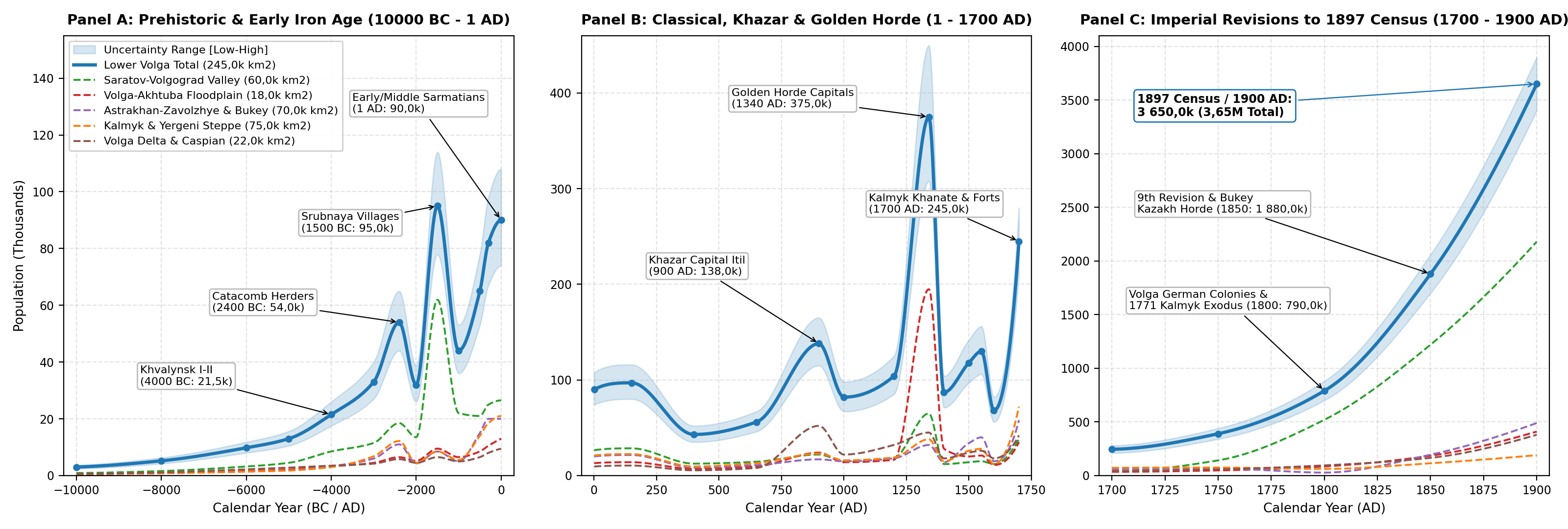
This paper reviews the archaeological, bioarchaeological and archival literature on the demographic and settlement history of the Lower Volga region (~ 245,0k km², encompassing the Volga Delta, the Volga-Akhtuba Floodplain, the Saratov-Volgograd river corridor, the Kalmyk-Yergeni steppes and the Astrakhan-Volgograd Trans-Volga semi-deserts) from the Early Mesolithic (10000BC) to the First All-Russian Imperial Census (1897 / 1900AD). Estimates are derived from regional field studies and archival records: radiocarbon chronologies and excavated pit-house floors at Varfolomeyevka, Kairshak, Tenteksor and Dzhangar [1][2][3][4], Copper Age cemeteries at Khvalynsk I-II and Maksimovka I [5][6], Bronze Age buried-soil and pastoral mobility studies [7][8], Late Bronze Age Srubnaya village inventories in the Saratov-Volgograd valleys (>850 villages) [9][10], Sauromatian-Sarmatian skeletal life tables (N > 2,3k skeletons) and Kalmyk pasture comparisons [11][12][13][14], excavations at Khazar Itil (Semibugry / Barany Bugor) and Pre-Mongol Saksin (Samosdelka) [15][16][17], Golden Horde urban and rural surveys (Ukek, Bagaevskoye, Beldzhamen, Sarai al-Jadid / Tsarevskoye, Sarai Batu / Selitrennoye and Hajji-Tarkhan) [18][19][20][21][22][23], 15th-17th century Astrakhan, Nogai and Kalmyk registers [24][25][26][27] and 18th-19th century Imperial revizii, Volga German colony records, Kalmyk and Inner Bukey Kazakh Horde returns and the 1897 Imperial Census [28][29][30][31][32][33][34][35][36][37][38][39]. Regional population grew from 3,0k (10000BC) to 95,0k during the Late Bronze Age Srubnaya expansion (1500BC), 97,0k in the Middle Sarmatian (Aorsi) period (150AD), 138,0k under the Khazar Khaganate (900AD) and 375,0k (308,0k-450,0k) in the Golden Horde heartland (1340AD). After Timur's 1395-1396 devastation of the floodplain cities (87,0k in 1400AD) and the 1557-1558 Nogai famine and plague (68,0k in 1600AD), Oirat-Kalmyk migration and Russian garrison founding lifted the population to 245,0k by 1700AD, before 18th- and 19th-century agricultural colonisation, Volga German settlement and railway industrialisation raised the total to 3 650,0k (3,65M) by 1900AD.
Background
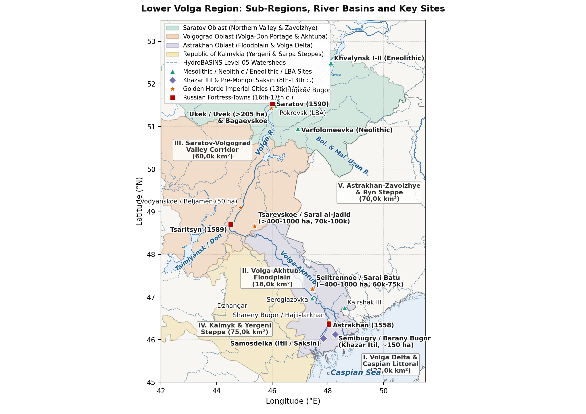
The Lower Volga region (~ 245,0k km²) is defined by the sharp ecological contrast between Europe's largest alluvial oasis - the 400 km-long Volga-Akhtuba Floodplain and fan-shaped Volga Delta - and the surrounding dry steppes and semi-deserts of the Caspian Depression (Figure 1). For regional demographic analysis, the territory is divided into five ecological sub-regions:
- Volga Delta and North-Western Caspian Littoral (22,0k km²): The branching channels of the Volga Delta (Bolda, Buzan, Bakhtemir), Baer knolls (Berovskiye bugry) and coastal lagoons (Seroglazovka, Kairshak, Tenteksor, Khazar Itil at Semibugry / Barany Bugor, Samosdelka [Saksin / Summerkent], Golden Horde Hajji-Tarkhan [Shareny Bugor], Krasnoyarskoye and Russian Astrakhan and Krasny Yar) [16][17].
- Volga-Akhtuba Floodplain (18,0k km²): The 15-45 km-wide alluvial gallery-forest and meadow corridor between the Volgograd (Tsaritsyn) bend and the upper delta apex, which hosted the imperial capitals of the Golden Horde (Sarai al-Jadid / Sarai Berke at Tsarevskoye Gorodishche, Sarai Batu / Sarai al-Mahrusa at Selitrennoye Gorodishche, the Ak-Sarai royal mausoleums at Lapas, and Russian Tsaritsyn, Chyorny Yar, Yenotayevsk and Tsarev) [18][19][21].
- Saratov-Volgograd Right Bank and Northern Trans-Volga (Zavolzhye) Valley Corridor (60,0k km²): The forest-steppe to dry-steppe transition along the main Volga channel, Medveditsa, Ilovlya, Bolshoy Irgiz and Yeruslan rivers (Varfolomeyevka, Khvalynsk I-II, Khlopkov Bugor, Pokrovsk, Golden Horde Ukek [Uvekskoye Gorodishche] with its 53-site agricultural district including Bagaevskoye Selishche, Beldzhamen [Vodyanskoye Gorodishche], Russian Saratov, Kamyshin, Volsk and Khvalynsk, and the 18th-19th century Volga German Bergseite and Wiesenseite colonies) [1][22][23][29].
- Kalmyk Steppe, Yergeni Hills and Sarpa Lakes (75,0k km²): The right-bank arid steppes stretching south of the Volga-Don portage along the Yergeni ridge, Sarpa lacustrine chain and Black Lands (Chyornye Zemli, including Neolithic Dzhangar, Bronze Age Manych Catacomb and Lola kurgan fields, 17th-19th century Kalmyk uluses, the Herrnhuter colony of Sarepta and Elista) [7][34][40][41].
- Astrakhan-Volgograd Trans-Volga (Zavolzhye) and Ryn-Caspian Steppe (70,0k km²): The left-bank semi-desert steppes between the Akhtuba valley and the Volga-Ural (Yaik) watershed (Elton, Baskunchak, Bolshoy and Maly Uzen rivers, 16th-century Nogai and 17th-18th century Torghut-Kalmyk winter pastures, and the 19th-century Inner / Bukey Kazakh Horde and Novouzensk steppes) [25][36].
Methodology
Population estimates across the Lower Volga combine five lines of historical and archaeological evidence:
- Radiocarbon Stratigraphy and Excavated House Plans: For the Mesolithic, Neolithic and Eneolithic (10000-3500BC), A. V. Baratskov [2], V. A. Smagin [3], A. A. Vybornov et al. [4], P. M. Koltsov [40] and A. I. Yudin [1] provide excavated pit-house floor areas (30-60 m² at Varfolomeyevka) and AMS radiocarbon series (89
dates by 2015, >200 by 2022), while S. A. Agapov et al. [5] and V. A. Tsibin and A. A. Shalapinin [6] establish Copper Age cemetery populations (201 skeletons at Khvalynsk I-II). - Bronze and Early Iron Age Settlement Inventories and Osteological Life Tables: For the Yamnaya, Poltavka, Catacomb, Pokrovsk, Srubnaya, Sauromatian and Sarmatian periods (3500BC-400AD), northern valley settlement inventories (>850 Srubnaya villages) [9][10] and buried-soil studies [8][14] are combined with M. A. Balabanova's [11][42][43][44] and E. V. Pererva and E. G. Zubareva's [13] skeletal life tables (
, , , , sex ratios) and A. S. Skripkin's [12] comparison of Sarmatian pastures with historical Kalmyk herd capacities. - Khazar and Golden Horde Urban Excavations and Rural Surveys: For the medieval delta and floodplain cities (740-1460AD), D. V. Vasilyev [15][16], E. D. Zilivinskaya [45] and D. S. Solovyev et al. [17] estimate Khazar (Itil at Semibugry / Barany Bugor and Samosdelka) and Pre-Mongol (Saksin) urban populations. For the Golden Horde heartland, V. L. Yegorov [18], G. A. Fyodorov-Davydov [46], Yu. A. Zeleneev and E. M. Pigarev [20][21], L. F. Nedashkovsky [19][22][47][48] and M. B. Shigapov [23] document built-up urban areas (Ukek >205 ha, Beldzhamen 50 ha, Tsarevskoye >400 ha core / >1,0k ha with suburbs, Selitrennoye ~ 380 ha core / ~ 1,0k ha with suburbs) and surrounding agricultural villages (53 selishcha around Ukek, 17 around Tsarevskoye).
- Nomadic San / Kibitka Rolls and Early Russian Garrison Registers (1460-1700AD): Archival studies by M. V. Moiseev [24], I. V. Zaitsev [49], A. V. Syzranov [50], V. V. Trepavlov [25], V. T. Tepkeev [26][41] and N. L. Muzraev [27] establish Great Horde, Astrakhan Tatar, Nogai san and Kalmyk kibitka (35,0k-45,0k tents = 160,0k-210,0k people) numbers alongside Russian Razryadny Prikaz fortress censuses.
- Imperial Tax Revisions (Revizii), Colonisation Rolls and the 1897 Census (1700-1900AD): For the 18th and 19th centuries, V. M. Kabuzan [28], I. R. Pleve [29], V. Dönninghaus [30], V. Yu. Solovyov [31], V. A. Brylyov [32], U. B. Ochirov [33], L. V. Okonova [34], V. A. Kyshpanakov [35], S. S. Belousov [36], R. N. Pirova [37] and N. A. Troynitsky [38][39] provide exact counts from the 1st-10th revizii (1719-1858), the 1764-1767 Volga German colony registers, the 1771 Kalmyk exodus records, the Inner (Bukey) Kazakh Horde censuses and the 1897 Imperial Census across Saratov and Astrakhan Governorates.1
Prehistoric Foragers to Sarmatian Nomads (10000BC - 400AD)
Mesolithic, Neolithic and Eneolithic (10000-3500BC)
Investigated by P. M. Koltsov [40] and V. A. Smagin [3], the Mesolithic of the Northern Caspian lowlands and Volga-Ural sands (10000-6800 cal BC) is represented by the Seroglazovka and Istay cultures (Seroglazovka, Zhe-Kalgan, Kairshak V), characterised by geometric flint microliths (segments, trapezes and parallelograms traced across the Lower Volga by Smagin [3]). Small mobile bands (15-35 persons per camp) hunted saiga, kulan and onager and fished along delta channels, with regional population growing gradually from 3,0k (10000BC, density 0,012 persons/km²) to 5,2k (8000BC).
As documented by A. V. Baratskov [2] and A. A. Vybornov et al. [4], the radiocarbon dataset for the Steppe Volga Neolithic expanded from 12 dates prior to 2007 to 89 dates by 2015 and more than 200 AMS dates by 2022, establishing the Northern Caspian and Lower Volga as one of the earliest pottery-making regions in Western Eurasia:
- Kairshak Sites (6800-5800 cal BC): At Kairshak I-III, Baibek and Kugat IV, flat-bottomed incised pottery and geometric microliths yielded AMS dates of 7950-7930 BP (6800-6500 cal BC) alongside light surface dwellings (15-28 m²) [2].
- Varfolomeyevka (Orlovka Culture, 6000-5000 cal BC): Excavated by A. I. Yudin [1] in the Saratov Trans-Volga, Varfolomeyevka preserves a 3,5 m cultural deposit across Layer 3 (6200-5800 cal BC), Layer 2B (5600-5300 cal BC) and Layer 2A (5200-4900 cal BC) [2], featuring permanent multi-room semi-subterranean pit-houses (poluzemlyanki of 30-60 m²) that housed 60-100 residents per phase.
- Tenteksor and Dzhangar (5600-4800 cal BC): At Tenteksor I and Dzhangar (Kalmykia, upper layer dated to 6564 +/- 44 BP / c. 5500 cal BC [2][40]), communities settled around freshwater limans in sub-rectangular pit-dwellings (35-50 m²), raising regional population to 9,8k (6000BC) and 13,0k (5000BC).
During the Eneolithic (4800-3500 cal BC), the cemeteries of Khvalynsk I (158 skeletons) and Khvalynsk II (43 skeletons) [5], Khlopkov Bugor and collective flat-grave burials such as Maksimovka I on the Samara-Volga steppe margin [6] document early Copper Age herding (cattle, sheep, goats and horses) and Balkan-Carpathian copper exchange. Terrestrial-herbivore AMS dates place Khvalynsk I-II between 4508-4340 cal BC and 4346-4171 cal BC (
Bronze Age and Sauromatian-Sarmatian Nomadic Confederacies (3500BC - 400AD)
During the Yamnaya (3300-2600 cal BC) and Middle Bronze Age Poltavka (2700-2100 cal BC) and Catacomb periods, mobile pastoralists using wheeled wagons expanded across the Saratov-Volgograd valleys, Yergeni Hills and Sarpa lakes [7][8], lifting regional population from 33,0k (3000BC) to 54,0k around 2400BC before the 2200-2000 cal BC dry phase (when settlement contracted during the Lola period to 32,0k at 2000BC).
The transition from the Potapovka / Pokrovsk (1900-1700 cal BC) chariot-warrior burials to the Srubnaya (Timber-Grave) Culture (1700-1100 cal BC) [9][10] produced a clear north-south contrast: the northern Saratov-Volgograd river valleys (60,0k km²) supported more than 850 permanent Srubnaya villages (poseleniya) with large timber-framed semi-subterranean houses (80-180 m², housing 62,0k mixed farmers and herders), whereas the southern Kalmyk and Astrakhan semi-deserts (185,0k km²) were used for seasonal dune camps (stoyanki, 33,0k mobile herders), giving a Late Bronze Age regional peak of 95,0k (78,0k-114,0k) at 1500BC (0,388 persons/km²).
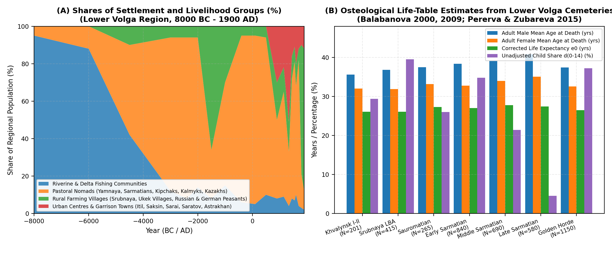
In the Early Iron Age (600BC-400AD), studied by A. S. Skripkin [12][44], V. M. Klepikov [51] and M. V. Krivosheev, E. V. Pererva and M. V. Eltsov [14], the Lower Volga passed from the Sauromatian (6th-4th c. BC, 65,0k) and Early Sarmatian (Prokhorovka, 4th-2nd c. BC, 82,0k at 300BC, followed by a mid-3rd-century BC dry-steppe pullback to 66,0k [51]) periods to the Middle Sarmatian (Susly / Aorsi Confederacy, 1st c. BC-mid-2nd c. AD) expansion (Kosika, Verkhnoye Pogromnoye). In a dedicated demographic study, A. S. Skripkin [12] compared Lower Volga Sarmatian burial densities against 18th- and 19th-century Kalmyk nomadic censuses (30,0k-45,0k kibitkas), showing that the Lower Volga pastures supported 65,0k-110,0k Sarmatian nomads (90,0k-97,0k midpoint in 1-150AD). Across more than 2,3k Lower Volga skeletons, M. A. Balabanova [11][42][43] and E. V. Pererva and E. G. Zubareva [13] recorded high child mortality in Srubnaya (39,5%) and Early Sarmatian (34,8%) cemeteries, contrasted with the customary exclusion of infants (
Khazar Heartland (Itil), Pre-Mongol Saksin, Golden Horde Imperial Capitals and the Kalmyk Khanate (400 - 1700AD)
Khazar Imperial Capital Itil (Semibugry and Samosdelka) and Pre-Mongol Saksin (740-1236AD)
Following the post-Hunnic population low (43,0k at 400AD) and the Arab-Khazar war of 737AD, the Khazar Khagan transferred his court permanently to the Lower Volga Delta (Itil / Atil):
- Semibugry and Barany Bugor (Семибугоринский археологический комплекс): Excavated since 2020 by D. S. Solovyev, D. V. Vasilyev and E. E. Kravchenko [17] along the Bolda delta channel in Kamyzyaksky District, Astrakhan Oblast, this large 8th-10th century Khazar urban and suburban complex covers ~ 150 ha, yielding Saltovo-Mayaki amphorae, Khazar royal tamga bricks, an 8th-century Abbasid silver dirham and monumental brick foundations (estimated urban population 25,0k-40,0k).
- Samosdelka (Самосдельское городище) and Pre-Mongol Saksin: Summarising 20 years of excavations (2000-2020), D. V. Vasilyev [15][16] showed that Samosdelka (~ 150-200 ha across three delta islands) preserves a lower Khazar layer (9th-10th c. AD) with a triangular burnt-brick fortress and yurt-shaped dwellings (10,0k-18,0k inhabitants), sealed by a fire-and-flood layer from Sviatoslav's 965/969AD campaign. Together with Kalmyk-steppe outposts (Bashanta I-II [52]) and floodplain herders, the Khazar Lower Volga reached 138,0k (115,0k-165,0k) at 900AD. In the 11th-early 13th centuries, the middle layer of Samosdelka flourished as the trading port of Saksin, where Abu Hamid al-Gharnati (1131-1153AD) described Oghuz, Bolgar, Suvar and Khazar quarters (matched directly to Samosdelka's four pottery traditions by Vasilyev [15]), supporting 15,0k-25,0k urban residents within a regional population of 104,0k at 1200AD.
Golden Horde Imperial Core on the Lower Volga (1240-1502AD)
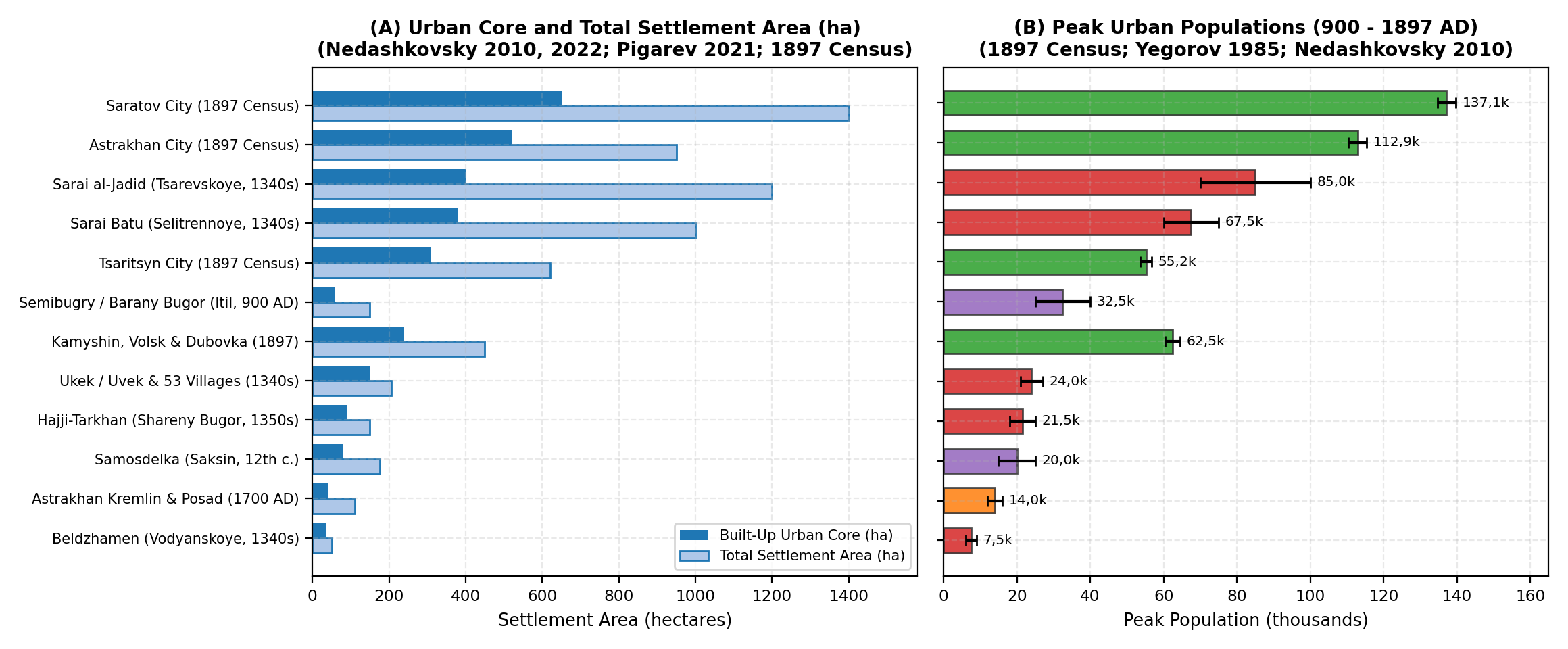
During the 1250s-1360s AD, the Lower Volga and Volga-Akhtuba Floodplain served as the personal domain of the Jochid Khans and the most heavily urbanised river corridor in Eastern Europe [18][19][46][53] (Figure 4):
- Ukek (Uvekskoye Gorodishche, modern Saratov) and Bagaevskoye Selishche: Stretching >3,5 km along the Volga right bank, Ukek covered >205 ha with brick palaces, mosques, bathhouses (hammams) and Christian and Muslim quarters, housing 9,0k-10,0k urban residents [19][47]. Across its 420 km² rural district (okruga), L. F. Nedashkovsky and M. B. Shigapov [19][22][23][48] mapped 53 rural settlements (3 satellite towns and 50 farming villages), exemplified by Bagaevskoye Selishche (5,1 ha, >90 cm cultural layer, excavated 2002-2021, yielding iron sickles, scythes, saws and fishhooks), which supported 12,0k-18,0k rural inhabitants.
- Beldzhamen / Bezdezh (Vodyanskoye Gorodishche, Dubovka): Covering 50 ha (6,0k-9,0k inhabitants), with distinct Russian Christian, Volga Bolgar (stone mosque and baths) and Kipchak-Mongol quarters [18][19].
- Sarai al-Jadid / Sarai Berke (Tsarevskoye Gorodishche, Leninsk): The 14th-century imperial capital encompassed a compact urban core of >400 ha (~1,55k aristocratic house mounds) and a suburban estate belt of >1,0k-1,5k ha, surrounded by 17 satellite villages [19], supporting a 1340s population of 70,0k-100,0k inhabitants [18][46][53].
- Sarai Batu / Sarai al-Mahrusa (Selitrennoye Gorodishche, Kharabali) and Ak-Sarai (Lapas): Stretching 7-12 km along the Akhtuba across ~ 380-400 ha of dense urban quarters and ~ 1,0k ha of suburban estates and workshops (mapped in 2000-2020 by Yu. A. Zeleneev and E. M. Pigarev [20][21]), Selitrennoye housed 60,0k-75,0k inhabitants.
- Volga Delta Golden Horde Cities: Hajji-Tarkhan (Shareny Bugor, 150 ha, 18,0k-25,0k), Summerkent (Samosdelka upper layer, 80-100 ha, 6,0k-10,0k [16]) and Krasnoyarskoye / Moshayk (5,0k-10,0k).
At the height of the Golden Horde in 1340AD, Lower Volga towns housed 170,0k-230,0k inhabitants, supported by 50,0k-70,0k settled floodplain farmers and fishermen and 100,0k-140,0k steppe pastoralists - giving a regional total of 375,0k (308,0k-450,0k, 1,531 persons/km²). Between the Black Death (1346), the civil wars of the Velikaya Zamyatnya (1359-1380) and Timur's winter campaign of 1395-1396AD, the floodplain cities lost roughly four-fifths of their inhabitants, reducing the regional population to 87,0k in 1400AD.
Astrakhan Khanate, Nogai Horde, Kalmyk Khanate and Russian Fortress Network (1460-1700AD)
As shown by M. V. Moiseev [24], I. V. Zaitsev [49] and A. V. Syzranov [50], the post-Jochid Astrakhan Khanate (1459-1556AD) centred at Hajji-Tarkhan supported an urban and semi-settled Yurt Tatar population of 15,0k-25,0k (fielding 3,0k cavalrymen), while V. V. Trepavlov [25] established from Manghit san lists that the Western uluses of the Nogai Horde wintering along the Lower Volga numbered 80,0k-120,0k nomads in 1500-1550AD (regional total 130,0k at 1550AD). Immediately after Ivan IV's annexation of Astrakhan (1554-1556), civil war and the severe winter freeze (dzhut), famine and plague of 1557-1558 (witnessed at Astrakhan by Anthony Jenkinson in 1558) devastated the Nogai uluses, reducing the regional population to 68,0k by 1600AD [25].
Between 1558 and 1700AD, two demographic movements reshaped the Lower Volga:
- Russian Garrison and Posad Network: Astrakhan (moved to Hare Island in 1558, stone Kremlin built 1582-1589) grew to 12,0k-16,0k permanent residents by 1700AD (including streltsy, Russian townspeople, Bukharan, Persian, Armenian and Indian merchant dvory and Yurt Tatar Muslim suburbs [50]), alongside Saratov (1590, 4,5k-7,0k urban plus 6,0k rural settlers), Tsaritsyn (1589, 2,5k-4,0k), Chyorny Yar (1627), Krasny Yar (1667) and Dmitriyevsk (Kamyshin, 1668) (~34,0k total Russian and settled inhabitants).
- The Kalmyk Migration and Khanate (1628-1700AD): Beginning in 1628-1632, Western Mongol (Oirat - Torghut, Derbet and Khoshut) tribes under Tayishi Kho Orluk migrated into the Lower Volga steppes [41]. Under Ayuka Khan (r. 1669-1724, granted the title of Khan in 1690), reinforced by new Derbet and Dzungar arrivals studied by V. T. Tepkeev [26] and N. L. Muzraev [27], the Kalmyk Khanate numbered 35,0k-45,0k kibitkas (160,0k-210,0k Kalmyks, fielding 20,0k-40,0k horsemen) plus 20,0k subordinate Nogai and Yurt Tatars, lifting the Lower Volga region to 245,0k (210,0k-280,0k, 1,000 persons/km²) in 1700AD.
Imperial Russian Colonisation, the Volga Germans, the 1771 Kalmyk Exodus and the 1897 Census (1700 - 1900AD)
Between 1700 and 1900AD, the Lower Volga was transformed from a pastoral frontier into one of Imperial Russia's major grain-exporting, fishing and river-shipping regions, expanding more than fourteen-fold from 245,0k (1700AD) to 3 650,0k (3,65M) by 1900AD (Figure 2B):
- The Tsaritsyn Defensive Line, Early Peasant Colonisation and the Volga German Colonies (1700-1800AD): Following the completion of the 60 km Tsaritsyn Defensive Line (Tsaritsynskaya storozhevaya liniya, 1718-1720) between the Volga and the Don and the establishment of the Dubovka Cossack Host (1734), Russian and Ukrainian state and landlord peasants settled the right-bank river valleys of Saratov and Kamyshin [28][31][32], lifting regional population to 390,0k by 1750AD. Under Catherine II's Manifestos of 1762 and 1763, analysed by I. R. Pleve [29] and V. Dönninghaus [30], 25,6k-27,0k German colonists settled 104 mother colonies between 1764 and 1767 along the Saratov-Kamyshin right bank (Bergseite) and northern Trans-Volga left bank (Wiesenseite), while Moravian Brethren (Herrnhuter) founded Sarepta near Tsaritsyn in 1765.
- The 1771 Kalmyk Exodus (Torghutsky Pobeg) and the Inner (Bukey) Kazakh Horde (1771-1850AD): In January 1771, Ubashi Khan led roughly 30,0k-33,0k left-bank Torghut and Khoshut kibitkas (~150,0k-170,0k people) eastwards out of the Lower Volga back towards Dzungaria, leaving only ~11,0k-13,0k right-bank Derbet and Torghut tents (~50,0k-60,0k Kalmyks) trapped west of the un-iced Volga [33][34][35]. This sudden depopulation of the Astrakhan Trans-Volga (Zavolzhye fell from 67,0k in 1750 to 28,0k in 1800AD, even as Saratov agricultural growth lifted the overall Lower Volga to 790,0k in 1800AD) prompted Paul I's decree of 11 March 1801 permitting Sultan Bukei Nuraliev to lead Junior Zhuz Kazakhs across the Ural into the Ryn Sands [36]. By 1850AD, the Inner (Bukey) Kazakh Horde (~100,0k-120,0k Kazakhs centred at Khanskaya Stavka), state-peasant salt-carters (chumaki) at Lakes Elton and Baskunchak, and rapid natural increase among the Volga Germans (reaching 165,0k by 1850) and Saratov peasantry raised the regional total to 1 880,0k (7,673 persons/km²) [28][30][36].
- Railway Industrialisation and the 1897 All-Russian Imperial Census (1850-1900AD): After the Emancipation of 1861, the opening of the Gryazi-Tsaritsyn (1871), Ryazan-Ural (1871-1894, linking Saratov and Pokrovskaya Sloboda) and Baskunchak (1882) railways, and the rise of Nobel Brothers' oil-tanker fleets at Astrakhan and Tsaritsyn, the First All-Russian Census of 28 January 1897 [38][39] provides an exact baseline for the five Lower Volga sub-regions:
- Saratov-Volgograd Valley Corridor (60,0k km²): Saratov Governorate recorded 2 405,8k inhabitants in 1897 [31][38]. Within the Lower Volga river and northern Trans-Volga districts (Saratov, Kamyshin, Tsaritsyn uplands, Volsk, Khvalynsk, Atkarsk and the Volga German canton of Novouzensk and Nikolayevsk uyezds [30][32]), population reached 2 180,0k by 1900AD, including ~390,0k-405,0k Volga Germans across mother and daughter colonies and the cities of Saratov (137,1k in 1897), Kamyshin (16,3k), Volsk (27,1k), Khvalynsk (15,1k) and Dubovka (16,3k).
- Volga-Akhtuba Floodplain (18,0k km²): Anchored by the booming railway-and-timber hub of Tsaritsyn (55,2k in 1897, up from 6,7k in 1861 [32]), Tsarev (6,9k), Chyorny Yar (4,2k), Yenotayevsk (2,8k), Vladimirovka and dense Russian, Ukrainian and Mordvinian orchard-and-fishery villages along the Akhtuba, population reached 410,0k in 1900AD.
- Volga Delta and North-Western Caspian Littoral (22,0k km²): Astrakhan Governorate recorded 1 003,5k inhabitants in 1897 [39]. The delta proper (Astrakhan uyezd 219,8k and Krasny Yar uyezd 66,0k, plus seasonal fishery workers and delta Tatar villages [37]) reached 380,0k by 1900AD, led by Astrakhan city (112,9k permanent residents in 1897, swelling by >100,0k seasonal fishermen and dockers each spring).
- Kalmyk Steppe and Yergeni Hills (75,0k km²): In the 1897 Census, analysed in detail by L. V. Okonova [34], U. B. Ochirov [33] and V. A. Kyshpanakov [35], the Kalmyk Steppe (Kalmytskaya step) of Astrakhan Governorate counted 128,6k nomadic Kalmyks plus ~10,0k Russian and Ukrainian settlers (total 138,6k in the steppe proper), alongside peasant road-villages (traktovye syola) along the Yergeni ridge (Elista, Remontnoye, Kresty) and Sarepta, giving 190,0k across the 75,0k km² sub-region in 1900AD.
- Astrakhan-Volgograd Trans-Volga and Ryn Steppe (70,0k km²): The Inner (Bukey) Kazakh Horde counted 214,8k inhabitants in 1897 (96,5% Kazakhs, plus sedentary trading settlements at Khanskaya Stavka, Talovka and Novaia Kazanka studied by S. S. Belousov [36]), which together with the Baskunchak and Elton salt-mining towns and the southern Trans-Volga volosts of Tsarev and Novouzensk uyezds totalled 490,0k in 1900AD (regional aggregate 3 650,0k, density 14,898 persons/km²).
| Settlement / Site | Sub-Region | Chronology | Core / Total Area (ha) | Estimated Population | Primary Literature |
|---|---|---|---|---|---|
| Varfolomeyevka (Neolithic) | Saratov Trans-Volga | 6000-5000 cal BC | 0,8 / 1,5 | 60-100 | Yudin 2004; Baratskov 2015 |
| Semibugry / Barany Bugor (Itil) | Volga Delta (Bolda arm) | 750-969AD | 60,0 / ~150,0 | 25,0k-40,0k (900AD) | Solovyev, Vasilyev et al. 2022 |
| Samosdelka (Itil / Saksin) | Volga Delta (Kamyzyak) | 9th-14th c. AD | 80,0 / 150,0-200,0 | 15,0k-25,0k (Saksin, 12th c.) | Vasilyev 2015, 2020; Zilivinskaya 2014 |
| Ukek (Uvekskoye) & 53 Selishcha | Saratov Right Bank | 1250s-1395AD | 150,0 / >205,0 (+53 sites) | 9,0k-10,0k (city) / 24,0k (dist.) | Nedashkovsky 2010, 2022; Shigapov 2022 |
| Beldzhamen (Vodyanskoye) | Volgograd Right Bank (Dubovka) | 1260s-1370s AD | 35,0 / 50,0 | 6,0k-9,0k (1340AD) | Yegorov 1985; Nedashkovsky 2010 |
| Sarai al-Jadid (Tsarevskoye) | Volga-Akhtuba (Leninsk) | 1320s-1395AD | 400,0 / 1,0k-1,5k (+17 sites) | 70,0k-100,0k (1340s AD) | Yegorov 1985; Nedashkovsky 2010 |
| Sarai Batu (Selitrennoye) | Volga-Akhtuba (Kharabali) | 1254-1480/1502AD | 380,0 / ~1,0k (7-12 km strip) | 60,0k-75,0k (1330s-1350s AD) | Zeleneev & Pigarev 2018; Pigarev 2021 |
| Hajji-Tarkhan (Shareny Bugor) | Volga Delta Apex | 1280s-1556AD | 90,0 / 150,0 | 18,0k-25,0k (1350) / 10,0k (1500) | Nedashkovsky 2010; Zaitsev 2006 |
| Krasnoyarskoye & Moshayk | Volga Delta | 1260s-1395AD | 45,0 / 80,0 | 5,0k-10,0k (14th c. AD) | Zilivinskaya 2014; Pigarev 2021 |
| Astrakhan (Kremlin, Posad & Port) | Volga Delta (Hare Isl.) | 1558-1900AD | 450,0 / 950,0 | 14,0k (1700) / 112,9k (1897) | Syzranov 2014; Troynitsky 1904 |
| Saratov | Saratov Right Bank | 1590-1900AD | 620,0 / 1,2k | 5,5k (1700) / 137,1k (1897) | Solovyov 2013; Troynitsky 1904 |
| Tsaritsyn (Volgograd) | Volga-Don Bend | 1589-1900AD | 280,0 / 550,0 | 3,2k (1700) / 55,2k (1897) | Brylyov 2018; Troynitsky 1904 |
| Kamyshin, Volsk & Dubovka | Saratov-Volgograd Volga | 1668-1900AD | 210,0 / 420,0 | 2,5k (1700) / 59,7k (1897) | Brylyov 2018; Troynitsky 1904 |
Limitations
Three practical constraints affect Lower Volga demographic estimates:
- Caspian Sea Level Fluctuations and Riverbank Erosion: Multi-metre Holocene rises and falls of the Caspian Sea (the Mangyshlak lowstand around 8000BC, the Novocaspian highstands and the 10th- and 14th-century transgressions) submerged or eroded delta sites (such as the Samosdelka fire-and-flood layer [16]), while lateral shifting of the Volga and Akhtuba channels has destroyed parts of Ukek, Beldzhamen and Selitrennoye [19][21].
- Chronological Overlap of the Twin Golden Horde Capitals (Selitrennoye and Tsarevskoye): Scholars continue to debate how much Sarai Batu (Selitrennoye) and Sarai al-Jadid (Tsarevskoye) overlapped in population during the 1330s-1360s AD [18][20][53]. Our 1340AD floodplain estimate (195,0k) accounts for partial transfer of residents between the two capitals rather than adding both at their maximum sizes.
- Seasonal Migration and Labour Mobility across Governorate Borders: Both the Nogai Horde (15th-16th c.), the Kalmyk Khanate (17th-18th c.) and the Inner Bukey Kazakh Horde (19th c.) shifted camps seasonally across the Ural, Lower Volga and Kuma-Manych steppes [25][26][36], while late 19th-century Astrakhan and Tsaritsyn attracted more than 150,0k seasonal spring and summer fishery and dock labourers outside the January 1897 census date [39]. Sub-regional figures reflect resident populations within the 245,0k km² Lower Volga polygon.
Conclusion
The Lower Volga region experienced repeated shifts between pastoral nomadism and dense riverine urbanisation across the Holocene. After early farming and nomadic growth during the Late Bronze Age Srubnaya village expansion (95,0k at 1500BC) and the Middle Sarmatian Aorsi confederacy (97,0k at 150AD), the Volga Delta and Volga-Akhtuba Floodplain twice served as the metropolitan heartland of Western Eurasian steppe empires: first under the Khazar Khaganate (Itil at Semibugry and Samosdelka, 138,0k in 900AD, followed by Pre-Mongol Saksin at 104,0k in 1200AD) and second under the Golden Horde (375,0k in 1340AD across Sarai al-Jadid, Sarai Batu, Ukek, Beldzhamen and Hajji-Tarkhan). Following Timur's 1395AD destruction of the floodplain cities and the 1557-1558 Nogai famine and plague (68,0k in 1600AD), 17th-century Oirat-Kalmyk migration (35,0k-45,0k kibitkas under Ayuka Khan) and Russian fortress founding (Astrakhan, Saratov, Tsaritsyn) restored regional population to 245,0k by 1700AD. Despite the 1771 departure of ~150,0k-170,0k left-bank Kalmyks, peasant and Volga German colonisation of the Saratov-Kamyshin valleys, the creation of the Inner (Bukey) Kazakh Horde (1801) and late 19th-century railway and shipping growth expanded the Lower Volga population to 3 650,0k (14,898 persons/km²) by 1900AD.
Appendix
Osteological Life-Table Estimates
| Archaeological Period | Sample (N) | Sub-Adult d(0-14) | Male AA (yrs) | Female AA (yrs) | Adult Sex Ratio (M/F) | Corrected e0 (yrs) | Sources |
|---|---|---|---|---|---|---|---|
| Khvalynsk I-II (Eneolithic) | 201 | 29,4% | 35,6 | 32,0 | 1,35 | 25,0-27,2 | Agapov et al. 1990 |
| Srubnaya (LBA, Lower Volga) | 415 | 39,5% | 36,8 | 31,9 | 1,08 | 24,8-27,4 | Balabanova 2000, 2009 |
| Sauromatian (6th-4th c. BC) | 265 | 26,0% | 37,5 | 33,2 | 1,32 | 26,2-28,5 | Balabanova 2009; Pererva 2015 |
| Early Sarmatian (Prokhorovka, 4th-2nd c. BC) | 840 | 34,8% | 38,4 | 32,8 | 1,18 | 25,8-28,2 | Balabanova 2009, 2013; Krivosheev 2021 |
| Middle Sarmatian (1st c. BC-mid-2nd c. AD) | 690 | 21,4% (kurgan bias) | 39,1 | 34,0 | 1,12 | 26,5-29,0 | Balabanova 2009; Krivosheev 2021 |
| Late Sarmatian (mid-2nd-4th c. AD) | 580 | 4,5% (ritual filter) | 40,8 | 35,1 | 2,15 (male skew) | 26,0-28,8 | Balabanova 2009; Pererva 2015 |
| Golden Horde (Ukek, Tsarevskoye, Selitrennoye) | 1,15k | 37,2% | 37,4 | 32,6 | 1,15 | 25,2-27,8 | Pererva 2015 |
Population Estimates
| Year | Volga Delta (22,0k km²) | Volga-Akhtuba (18,0k km²) | Saratov-Volgograd (60,0k km²) | Kalmyk Steppe (75,0k km²) | Zavolzhye (70,0k km²) | Total Population [Range] | Density (p/km²) |
|---|---|---|---|---|---|---|---|
| 10000BC | 0,6k | 0,5k | 0,9k | 0,5k | 0,5k | 3,0k [2,4k-3,7k] | 0,012 |
| 8000BC | 1,1k | 0,9k | 1,6k | 0,8k | 0,8k | 5,2k [4,2k-6,3k] | 0,021 |
| 6000BC | 2,2k | 1,6k | 3,2k | 1,4k | 1,4k | 9,8k [8,0k-11,8k] | 0,040 |
| 5000BC | 2,8k | 2,1k | 4,5k | 1,8k | 1,8k | 13,0k [10,5k-15,6k] | 0,053 |
| 4000BC | 3,5k | 3,2k | 8,5k | 3,0k | 3,3k | 21,5k [17,5k-26,0k] | 0,088 |
| 3000BC | 4,2k | 4,5k | 11,5k | 6,8k | 6,0k | 33,0k [27,0k-40,0k] | 0,135 |
| 2400BC | 5,8k | 6,5k | 18,5k | 12,2k | 11,0k | 54,0k [44,0k-65,0k] | 0,220 |
| 2000BC | 4,5k | 5,2k | 13,5k | 4,5k | 4,3k | 32,0k [26,0k-38,5k] | 0,131 |
| 1500BC | 6,5k | 9,5k | 62,0k | 8,5k | 8,5k | 95,0k [78,0k-114,0k] | 0,388 |
| 1000BC | 5,0k | 6,5k | 22,0k | 5,5k | 5,0k | 44,0k [36,0k-53,0k] | 0,180 |
| 500BC | 6,5k | 8,5k | 21,0k | 14,0k | 15,0k | 65,0k [53,0k-78,0k] | 0,265 |
| 300BC | 8,0k | 10,5k | 25,0k | 18,5k | 20,0k | 82,0k [67,0k-98,0k] | 0,335 |
| 1AD | 9,5k | 13,0k | 26,5k | 21,0k | 20,0k | 90,0k [74,0k-108,0k] | 0,367 |
| 150AD | 10,5k | 14,0k | 28,5k | 22,5k | 21,5k | 97,0k [80,0k-116,0k] | 0,396 |
| 400AD | 5,5k | 7,0k | 12,5k | 9,5k | 8,5k | 43,0k [35,0k-52,0k] | 0,176 |
| 650AD | 8,0k | 9,5k | 14,5k | 13,0k | 11,0k | 56,0k [46,0k-67,0k] | 0,229 |
| 900AD | 52,0k | 24,0k | 22,0k | 23,0k | 17,0k | 138,0k [115,0k-165,0k] | 0,563 |
| 1000AD | 22,0k | 14,0k | 15,0k | 16,0k | 15,0k | 82,0k [67,0k-98,0k] | 0,335 |
| 1200AD | 32,0k | 16,5k | 18,5k | 19,0k | 18,0k | 104,0k [85,0k-125,0k] | 0,424 |
| 1340AD | 45,0k | 195,0k | 65,0k | 38,0k | 32,0k | 375,0k [308,0k-450,0k] | 1,531 |
| 1400AD | 18,0k | 28,0k | 12,0k | 15,0k | 14,0k | 87,0k [71,0k-104,0k] | 0,355 |
| 1500AD | 24,0k | 20,0k | 14,0k | 26,0k | 34,0k | 118,0k [97,0k-142,0k] | 0,482 |
| 1550AD | 26,0k | 21,0k | 15,0k | 28,0k | 40,0k | 130,0k [106,0k-156,0k] | 0,531 |
| 1600AD | 18,0k | 11,0k | 12,0k | 12,0k | 15,0k | 68,0k [56,0k-82,0k] | 0,278 |
| 1700AD | 42,0k | 35,0k | 38,0k | 72,0k | 58,0k | 245,0k [210,0k-280,0k] | 1,000 |
| 1750AD | 58,0k | 48,0k | 142,0k | 75,0k | 67,0k | 390,0k [340,0k-440,0k] | 1,592 |
| 1800AD | 95,0k | 85,0k | 520,0k | 62,0k | 28,0k | 790,0k [700,0k-880,0k] | 3,224 |
| 1850AD | 165,0k | 185,0k | 1 220,0k | 115,0k | 195,0k | 1 880,0k [1 700,0k-2 060,0k] | 7,673 |
| 1900AD | 380,0k | 410,0k | 2 180,0k | 190,0k | 490,0k | 3 650,0k [3 400,0k-3 900,0k] | 14,898 |
Sources
1.Yudin, Aleksandr Ivanovich. Varfolomeyevskaya stoyanka i neolit stepnogo Povolzh'ya [The Varfolomeyevka Site and the Neolithic of the Steppe Volga Region]. Saratov State University Press, 2004, pp. 1-200.
2.Baratskov, Aleksey Valeryevich. "Itogi radiouglerodnogo datirovaniya materialov neolita stepnogo Povolzh'ya [Results of Radiocarbon Dating of Neolithic Materials of the Steppe Volga Region]." Izvestiya Samarskogo nauchnogo tsentra Rossiyskoy akademii nauk, vol. 17, no. 3, 2015, pp. 228-234, https://cyberleninka.ru/article/n/itogi-radiouglerodnogo-datirovaniya-materialov-neolita-stepnogo-povolzhya, Archived PDF (baratskov_aleksey_valerevich_2015_itogi_radiouglerodnogo_datirovaniya_mater.pdf).
3.Smagin, Valeriy Andreyevich. "Istoriya izucheniya pamyatnikov s nalichiyem v inventare geometricheskikh mikrolitov s territorii Nizhnego Povolzh'ya [History of the Study of Sites Containing Geometric Microliths from the Territory of the Lower Volga Region]." Izvestiya Samarskogo nauchnogo tsentra Rossiyskoy akademii nauk, vol. 20, no. 3, 2018, pp. 467-473, https://cyberleninka.ru/article/n/istoriya-izucheniya-pamyatnikov-s-nalichiem-v-inventare-geometricheskih-mikrolitov-s-territorii-nizhnego-povolzhya, Archived PDF (smagin_valeriy_andreevich_2018_istoriya_izucheniya_pamyatnikov_s_nalichiem.pdf).
4.Vybornov, Aleksandr Alekseyevich, et al. "Khronologiya neolita - eneolita stepnogo Povolzh'ya [Chronology of the Neolithic - Eneolithic of the Steppe Volga Region]." Vestnik Volgogradskogo gosudarstvennogo universiteta. Seriya 4, Istoriya, vol. 27, no. 3, 2022, pp. 6-15, https://doi.org/10.15688/jvolsu4.2022.3.1.
5.Agapov, Sergey Aleksandrovich, et al. Khvalynskiy eneoliticheskiy mogil'nik [The Khvalynsk Eneolithic Cemetery]. Saratov University Press (Kuibyshev Branch), 1990, pp. 1-160.
6.Tsibin, Viktor Aleksandrovich, and Anton Aleksandrovich Shalapinin. "Pogrebeniye epokhi eneolita gruntovogo mogil'nika Maksimovka I iz Samarskogo Zavolzh'ya [The Eneolithic Burial of Maksimovka I Soil Burial Ground from the Samara Trans-Volga Region]." Vestnik Volgogradskogo gosudarstvennogo universiteta. Seriya 4, Istoriya, vol. 24, no. 3, 2019, pp. 6-16, https://doi.org/10.15688/jvolsu4.2019.3.1, Archived PDF (tsibin_viktor_aleksandrovich_2019_pogrebenie_epohi_eneolita_gruntovogo_mogi.pdf).
7.Shishlina, Natalya Ivanovna. Reconstruction of the Bronze Age of the Caspian Steppes: Life Styles and Life Ways of Pastoral Nomads. Archaeopress, 2008, pp. 1-399, https://doi.org/10.30861/9781407303567.
8.Borisov, Aleksandr Vladimirovich, and Roman Alekseyevich Mimokhod. "Palaeosols and Natural Conditions of the South Russian Steppes in the Bronze Age." Arid Ecosystems, vol. 9, no. 1, 2019, pp. 12-21, https://doi.org/10.1134/S2079096119010037, Archived PDF (borisov_mimokhod_2019_steppe_bronze_age_palaeosols.pdf).
9.Malov, Nikolay Mikhaylovich. Nizhneye Povolzh'ye v epokhu kamnya, medi i bronzy [The Lower Volga in the Stone, Copper and Bronze Ages]. Saratov State University Press, 2008, pp. 1-210.
10.Lopatin, Vladimir Alekseyevich. Nachalo epokhi pozdney bronzy na severe Nizhnego Povolzh'ya [The Beginning of the Late Bronze Age in the North of the Lower Volga Region]. Saratov State University Press, 2014, pp. 1-228.
11.Balabanova, Mariya Afanasyevna. "Khronologicheskiye osobennosti polovozrastnoy struktury savromato-sarmatskogo naseleniya Nizhnego Povolzh'ya i Yuzhnogo Priural'ya [Chronological Features of the Age-Sex Structure of the Sauromatian-Sarmatian Population of the Lower Volga and Southern Urals]." Vestnik Volgogradskogo gosudarstvennogo universiteta. Seriya 4, Istoriya, no. 1 (15), 2009, pp. 5-12, https://cyberleninka.ru/article/n/hronologicheskie-osobennosti-polovozrastnoy-struktury-savromato-sarmatskogo-naseleniya-nizhnego-povolzhya-i-yuzhnogo-priuralya, Archived PDF (balabanova_mariya_afanasevna_2009_hronologicheskie_osobennosti_polovozrastn.pdf).
12.Skripkin, Anatoliy Stepanovich. "K probleme opredeleniya chislennosti sarmatskogo naseleniya v Nizhnem Povolzh'ye [On the Problem of Determining the Size of the Sarmatian Population in the Lower Volga Region]." Vestnik Volgogradskogo gosudarstvennogo universiteta. Seriya 4, Istoriya, no. 1 (21), 2012, pp. 20-23, https://cyberleninka.ru/article/n/k-probleme-opredeleniya-chislennosti-sarmatskogo-naseleniya-v-nizhnem-povolzhie, Archived PDF (skripkin_anatoliy_stepanovich_2012_k_probleme_opredeleniya_chislennosti_sar.pdf).
13.Pererva, Yevgeniy Vladimirovich, and Yelena Gennadyevna Zubareva. "K istorii paleoantropologicheskogo izucheniya sarmatskikh plemen Nizhnego Povolzh'ya (osteologiya, paleodemografiya i paleopatologiya) [On the History of Palaeoanthropological Study of the Sarmatian Tribes of the Lower Volga]." Izvestiya Volgogradskogo gosudarstvennogo pedagogicheskogo universiteta, 2015, pp. 173-184, https://cyberleninka.ru/article/n/k-istorii-paleoantropologicheskogo-izucheniya-sarmatskih-plemen-nizhnego-povolzhya-osteologiya-paleodemografiya-i-paleopatologiya, Archived PDF (pererva_evgeniy_vladimirovich_2015_k_istorii_paleoantropologicheskogo_izuch.pdf).
14.Krivosheev, Mikhail Vasilyevich, et al. "Chelovek i step' v rannem zheleznom veke (po materialam Nizhnego Povolzh'ya) [Man and the Steppe in the Early Iron Age (Based on Materials of the Lower Volga Region)]." Vestnik Volgogradskogo gosudarstvennogo universiteta. Seriya 4, Istoriya, vol. 26, no. 2, 2021, pp. 6-30, https://doi.org/10.15688/jvolsu4.2021.2.1, Archived PDF (krivosheev_mikhail_vasilevich_2021_chelovek_i_step_v_rannem_zheleznom_veke.pdf).
15.Vasilyev, Dmitriy Viktorovich. "Gorod Saksin: mestopolozheniye i naseleniye (po pis'mennym istochnikam i materialam Samosdel'skogo gorodishcha) [The City of Saksin: Location and Population]." Uchenyye zapiski Kazanskogo universiteta. Seriya Gumanitarnyye nauki, vol. 157, no. 3, 2015, pp. 12-24, https://cyberleninka.ru/article/n/gorod-saksin-mestopolozhenie-i-naselenie-po-pismennym-istochnikam-i-materialam-samosdelskogo-gorodischa, Archived PDF (vasilev_dmitriy_viktorovich_2015_gorod_saksin_mestopolozhenie_i_naselenie_p.pdf).
16.Vasilyev, Dmitriy Viktorovich. "Dvadtsat' let issledovaniy Samosdel'skogo gorodishcha: rezul'taty i perspektivy [Twenty Years of Investigations at the Samosdelka Settlement: Results and Prospects]." Trudy Kamskoy arkheologo-etnograficheskoy ekspeditsii (KAEE PGGPU), no. 16, 2020, pp. 64-75, https://doi.org/10.24411/2658-7637-2020-11609, Archived PDF (d_v_vasilev_2020_dvadtsat_let_issledovaniy_samosdelskogo_gorodischa_rezulta.pdf).
17.Solovyev, Damir Sergeyevich, et al. "Issledovaniya Semibugorinskogo arkheologicheskogo kompleksa v del'te Volgi [Investigations of the Semibugry Archaeological Complex in the Volga Delta]." Astrakhanskiy krayevedcheskiy vestnik, 2022, https://casp-geo.ru/v-astrahanskoj-oblasti-prodolzhayutsya-poiski-stolitsy-hazarskogo-kaganata/.
18.Yegorov, Vadim Leonidovich. Istoricheskaya geografiya Zolotoy Ordy v XIII-XIV vv. [Historical Geography of the Golden Horde in the 13th-14th Centuries]. Nauka, 1985, pp. 1-246.
19.Nedashkovsky, Leonard Fyodorovich. Zolotoordynskiye goroda Nizhnego Povolzh'ya i ikh okruga [The Golden Horde Cities of the Lower Volga and Their Periphery]. Vostochnaya Literatura RAN, 2010, pp. 1-351.
20.Zeleneev, Yuriy Anatolyevich, and Yevgeniy Mikhaylovich Pigarev. "Raboty arkheologicheskoy ekspeditsii na Selitrennom gorodishche v XXI v. [Works of the Archaeological Expedition at the Selitrennoye Settlement in the 21st Century]." Povolzhskaya Arkheologiya, no. 4 (26), 2018, pp. 235-247, https://doi.org/10.24852/2018.4.26.235.247, Archived PDF (zeleneev_yuriy_anatolevich_2018_raboty_arheologicheskoy_ekspeditsii_na_seli.pdf).
21.Pigarev, Yevgeniy Mikhaylovich. "Novyye dannyye k topografii Selitrennogo gorodishcha [New Data on the Topography of the Selitrennoye Settlement]." Arkheologiya Yevraziyskikh Stepey, no. 3, 2021, pp. 269-272, https://doi.org/10.24852/2587-6112.2021.3.269.272, Archived PDF (pigarev_evgeniy_mikhaylovich_2021_novye_dannye_k_topografii_selitrennogo_go.pdf).
22.Nedashkovsky, Leonard Fyodorovich, and Marat Bayazitovich Shigapov. "Zheleznyye predmety s Bagayevskogo selishcha [Iron Objects from the Bagaevskoye Settlement]." Arkheologiya Yevraziyskikh Stepey, no. 1, 2022, pp. 202-212, https://doi.org/10.24852/2587-6112.2022.1.202.212, Archived PDF (nedashkovskiy_leonard_fedorovich_2022_zheleznye_predmety_s_bagaevskogo_seli.pdf).
23.Shigapov, Marat Bayazitovich. "Istoriya izucheniya zolotoordynskikh selishch tsentral'noy chasti Saratovskogo Povolzh'ya [History of the Study of Golden Horde Rural Settlements in the Central Part of the Saratov Volga Region]." Problemy istorii, filologii, kul'tury, no. 2 (76), 2022, pp. 227-243, https://doi.org/10.18503/1992-0431-2022-2-76-227-243, Archived PDF (shigapov_marat_bayazitovich_2022_istoriya_izucheniya_zolotoordynskih_selisc.pdf).
24.Moiseev, Maksim Vladimirovich. "Stepnyye voyny ot Ugry do nogayskogo pogroma Kryma (1480-1522 gg.) [Steppe Wars from the Ugra to the Nogai Pogrom of Crimea (1480-1522)]." Istoriya voyennogo dela: issledovaniya i istochniki, vol. Special Issue V, Part I, 2015, pp. 1-44, https://cyberleninka.ru/article/n/stepnye-voyny-ot-ugry-do-nogayskogo-pogroma-kryma-1480-1522-gg, Archived PDF (moiseev_m_v_2015_stepnye_voyny_ot_ugry_do_nogayskogo_pogroma_kryma_1480_152.pdf).
25.Trepavlov, Vadim Vintserovich. Istoriya Nogayskoy Ordy [History of the Nogai Horde]. Kazanskaya Nedvizhimost', 2016, pp. 1-764, https://archive.org/details/istoriya-nogayskoy-ordy.
26.Tepkeev, Vladimir Toltayevich. "Kalmytsko-dzhungarskiye otnosheniya v kontse XVII - nachale XVIII veka [Kalmyk-Dzungar Relations at the End of the 17th - Beginning of the 18th Century]." Novyy istoricheskiy vestnik, no. 2 (84), 2025, pp. 257-271, https://doi.org/10.54770/20729286-2025-2-257, Archived PDF (tepkeev_vladimir_toltaevich_2025_kalmytsko_dzhungarskie_otnosheniya_v_konts.pdf).
27.Muzraev, Nikolay Lidzhiyevich. "Uchastiye kalmykov v Russko-turetskoy voyne 1735-1739 gg.: istoriograficheskiy aspekt [Participation of the Kalmyks in the Russo-Turkish War of 1735-1739: A Historiographical Aspect]." Byulleten' Kalmytskogo nauchnogo tsentra RAN, 2025, pp. 94-105, https://cyberleninka.ru/article/n/uchastie-kalmykov-v-russko-turetskoy-voyne-1735-1739-gg-istoriograficheskiy-aspekt1, Archived PDF (nikolay_lidzhievich_muzraev_2025_uchastie_kalmykov_v_russko_turetskoy_voyne.pdf).
28.Kabuzan, Vladimir Maksimovich. Narodonaseleniye Rossii v XVIII - pervoy polovine XIX v. (po materialam reviziy) [Population of Russia in the 18th - First Half of the 19th Century (Based on Revision Materials)]. Izdatel'stvo Akademii nauk SSSR, 1963, pp. 1-230.
29.Pleve, Igor Rudolfovich. Nemetskiye kolonii na Volge vo vtoroy polovine XVIII veka [German Colonies on the Volga in the Second Half of the 18th Century]. Gotika, 1998, pp. 1-448.
30.Doenninghaus, Viktor. "Chto russkomu khorosho, to nemtsu - smert'?: zemel'nyye otnosheniya i agrarnaya reforma v nemetskikh koloniyakh Povolzh'ya (1900-1914) [Land Relations and Agrarian Reform in the German Colonies of the Volga Region (1900-1914)]." Trudy po rossiyevedeniyu, no. 3, 2011, pp. 231-252, https://cyberleninka.ru/article/n/chto-russkomu-horosho-to-nemtsu-smert-zemelnye-otnosheniya-i-agrarnaya-reforma-v-nemetskih-koloniyah-povolzhya-1900-1914, Archived PDF (d_nningkhaus_viktor_2011_chto_russkomu_khorosho_to_nemtsu_smert_ze.pdf).
31.Solovyov, V. Yu., et al. "Osobennosti dorevolyutsionnogo issledovaniya etnokonfessional'noy tematiki (na primere Saratovskoy gubernii) [Features of Pre-Revolutionary Study of Ethno-Confessional Themes (On the Example of Saratov Governorate)]." Ekonomika i sotsium, no. 4 (9), 2013, pp. 1-8, https://cyberleninka.ru/article/n/osobennosti-dorevolyutsionnogo-issledovaniya-etnokonfessionalnoy-tematiki-na-primere-saratovskoy-gubernii, Archived PDF (solov_v_v_yu_2013_osobennosti_dorevolyutsionnogo_issledovaniya_etn.pdf).
32.Brylyov, Viktor Andreyevich. "Formirovaniye territorii Volgogradskoy oblasti i aglomeratsii v XX stoletii: granitsy, administrativnoye ustroystvo [Formation of the Territory of Volgograd Oblast and Agglomeration: Borders and Administrative Structure]." Izvestiya Volgogradskogo gosudarstvennogo pedagogicheskogo universiteta, no. 3 (126), 2018, pp. 195-204, https://cyberleninka.ru/article/n/formirovanie-territorii-volgogradskoy-oblasti-i-aglomeratsii-v-xx-stoletii-granitsy-administrativnoe-ustroystvo, Archived PDF (bryl_v_viktor_andreevich_2018_formirovanie_territorii_volgogradskoy_oblasti.pdf).
33.Ochirov, Utash Borisovich. "Tyurkoyazychnyye etnicheskiye gruppy v sostave Kalmytskogo khanstva (XVII - XVIII vv.) [Turkic-Speaking Ethnic Groups within the Kalmyk Khanate (17th - 18th Centuries)]." Vestnik Instituta kompleksnykh issledovaniy aridnykh territoriy, no. 2 (17), 2008, pp. 78-84, https://cyberleninka.ru/article/n/tyurkoyazychnye-etnicheskie-gruppy-v-sostave-kalmytskogo-hanstva-xvii-xviii-vv, Archived PDF (ochirov_u_b_2008_tyurkoyazychnye_etnicheskie_gruppy_v_sostave_kalm.pdf).
34.Okonova, Lyudmila Vyacheslavovna. "Voprosy migratsii v Kalmytskoy stepi Astrakhanskoy gubernii: opyt istochnikovedcheskogo analiza (po materialam perepisi 1897 g.) [Issues of Migration in the Kalmyk Steppe of Astrakhan Governorate: Source Analysis Based on the 1897 Census]." Oriental Studies, no. 2, 2012, pp. 43-48, https://cyberleninka.ru/article/n/voprosy-migratsii-v-kalmytskoy-stepi-astrahanskoy-gubernii-opyt-istochnikovedcheskogo-analiza-po-materialam-perepisi-1897-g, Archived PDF (okonova_l_v_2012_voprosy_migratsii_v_kalmytskoy_stepi_astrakhansk.pdf).
35.Kyshpanakov, Vladimir Alekseyevich. "Kalmyki Astrakhanskoy gubernii v zerkale perepisi 1897 g. Chast' III [The Kalmyks of Astrakhan Governorate in the Mirror of the 1897 Census. Part III]." Vestnik Kalmytskogo universiteta, no. 1 (69), 2026, pp. 22-31, https://cyberleninka.ru/article/n/kalmyki-astrahanskoy-gubernii-v-zerkale-perepisi-1897-g-chast-iii, Archived PDF (kyshpanakov_v_a_2026_kalmyki_astrakhanskoy_gubernii_v_zerkale_perep.pdf).
36.Belousov, Sergey Stepanovich. "Rol' torgovo-remeslennogo naseleniya v sozdanii statsionarnykh poseleniy na zemlyakh kazakhov Vnutrenney kirgizskoy ordy Astrakhanskoy gubernii. XIX v. [The Role of the Trade and Craft Population in Creating Permanent Settlements in the Lands of the Inner Kirghiz Horde of Astrakhan Governorate in the 19th Century]." Oriental Studies, no. 4, 2019, pp. 616-626, https://doi.org/10.22162/2619-0990-2019-44-4-616-626, Archived PDF (belousov_sergey_stepanovich_2019_rol_torgovo_remeslennogo_naseleniya_v_sozd.pdf).
37.Pirova, Rena Nizamiyevna. "Perepiska o tatarakh 1823 goda - delo iz fondov Gosudarstvennogo arkhiva Astrakhanskoy oblasti [Correspondence on the Tatars of 1823 from the State Archive of Astrakhan Oblast]." Gasyrlar avazy - Ekho vekov, no. 3, 2020, pp. 134-142, https://cyberleninka.ru/article/n/perepiska-o-tatarah-1823-goda-delo-iz-fondov-gosudarstvennogo-arhiva-astrahanskoy-oblasti, Archived PDF (pirova_rena_nizamievna_2020_perepiska_o_tatarakh_1823_goda_delo_iz_fon.pdf).
38.Troynitsky, Nikolay Aleksandrovich. Pervaya vseobshchaya perepis' naseleniya Rossiyskoy imperii, 1897 g. Tom XXXVIII: Saratovskaya guberniya [First General Census of the Population of the Russian Empire, 1897. Vol. XXXVIII: Saratov Governorate]. Tsentral'nyy statisticheskiy komitet MVD, 1904, pp. 1-215.
39.Troynitsky, Nikolay Aleksandrovich. Pervaya vseobshchaya perepis' naseleniya Rossiyskoy imperii, 1897 g. Tom II: Astrakhanskaya guberniya [First General Census of the Population of the Russian Empire, 1897. Vol. II: Astrakhan Governorate]. Tsentral'nyy statisticheskiy komitet MVD, 1904, pp. 1-184.
40.Koltsov, Pyotr Mikhaylovich. Mezolit i neolit Severo-Zapadnogo Prikaspiya [Mesolithic and Neolithic of the North-Western Caspian Region]. Voskresen'ye, 2005, pp. 1-352.
41.Tepkeev, Vladimir Toltayevich. Kalmyki v Severnom Prikaspii vo vtoroy treti XVII veka [The Kalmyks in the Northern Caspian Region in the Second Third of the 17th Century]. KIGI RAN, 2012, pp. 1-376.
42.Balabanova, Mariya Afanasyevna. Antropologiya drevnego naseleniya Yuzhnogo Priural'ya i Nizhnego Povolzh'ya. Ranniy zheleznyy vek [Anthropology of the Ancient Population of the Southern Urals and Lower Volga: Early Iron Age]. Nauka, 2000, pp. 1-133.
43.Balabanova, Mariya Afanasyevna. "Detskaya smertnost' u kochevnikov rannesarmatskogo vremeni Nizhnego Povolzh'ya [Child Mortality among Early Sarmatian Nomads of the Lower Volga]." Vestnik Volgogradskogo gosudarstvennogo universiteta. Seriya 4, Istoriya, no. 2 (24), 2013, pp. 6-14, https://jvolsu.com/index.php/ru/archive-ru/230-vestnik-volgu-seriya-4-2013-2-24.
44.Balabanova, Mariya Afanasyevna, and Aleksandr Nikolayevich Dyachenko. "Spisok opublikovannykh rabot professora A. S. Skripkina [List of Published Works of Professor A. S. Skripkin]." Vestnik Volgogradskogo gosudarstvennogo universiteta. Seriya 4, Istoriya, no. 5 (35), 2015, pp. 154-170, https://cyberleninka.ru/article/n/spisok-opublikovannyh-rabot-professora-a-s-skripkina, Archived PDF (balabanova_mariya_afanasevna_2015_spisok_opublikovannyh_rabot_professora_a.pdf).
45.Zilivinskaya, Emma Davidovna. Ocherki kul'tovogo i grazhdanskogo zodchestva Zolotoy Ordy [Essays on the Religious and Civil Architecture of the Golden Horde]. Institute of Ethnology and Anthropology RAS, 2014, pp. 1-268.
46.Fyodorov-Davydov, German Alekseyevich. Zolotoordynskiye goroda Povolzh'ya [The Golden Horde Cities of the Volga Region]. Moscow State University Press, 1994, pp. 1-228.
47.Nedashkovsky, Leonard Fyodorovich. Zolotoordynskiy gorod Ukek i yego okruga [The Golden Horde City of Ukek and its Periphery]. Vostochnaya Literatura, 2000, pp. 1-224, https://doi.org/10.30861/9781841715872.
48.Nedashkovsky, Leonard Fyodorovich, and Marat Bayazitovich Shigapov. "Zheleznyye izdeliya s Bagayevskogo selishcha (Chast' 2) [Iron Artefacts from the Bagaevskoye Settlement (Part 2)]." Arkheologiya Yevraziyskikh Stepey, no. 3, 2022, pp. 288-294, https://doi.org/10.24852/2587-6112.2022.3.288.294, Archived PDF (nedashkovskiy_leonard_fedorovich_2022_zheleznye_izdeliya_s_bagaevskogo_seli.pdf).
49.Zaitsev, Ilya Vladimirovich. Astrakhanskoye khanstvo [The Astrakhan Khanate]. Vostochnaya Literatura RAN, 2006, pp. 1-303.
50.Syzranov, Andrey Vyacheslavovich. "Musul'manskaya knizhnaya kul'tura Astrakhani [Muslim Book Culture of Astrakhan]." Islamovedeniye, no. 2, 2014, pp. 62-67, https://cyberleninka.ru/article/n/musulmanskaya-knizhnaya-kultura-astrahani, Archived PDF (syzranov_a_v_2014_musulmanskaya_knizhnaya_kultura_astrahani.pdf).
51.Klepikov, Valeriy Mikhaylovich. Sarmaty Nizhnego Povolzh'ya v IV-III vv. do n.e. [The Sarmatians of the Lower Volga in the 4th-3rd Centuries BC]. Volgograd State University Press, 2002, pp. 1-216, https://cyberleninka.ru/article/n/2004-02-030-klepikov-v-m-sarmaty-nizhnego-povolzhya-v-iv-iii-vv-do-n-e-volgograd-izd-vo-volgogr-un-ta-2002-216-s, Archived PDF (medovichev_a_e_2004_2004_02_030_klepikov_v_m_sarmaty_nizhnego_povolzhya_v_i.pdf).
52.Ochir-Goryaeva, Mariya Aleksandrovna. "Gorodishcha Bashanta-I i Bashanta-II epokhi Khazarskogo kaganata [Fortified Settlements of Bashanta-I and Bashanta-II of the Khazar Khaganate Epoch]." Oriental Studies, vol. 13, no. 4, 2020, pp. 830-842, https://doi.org/10.22162/2619-0990-2020-50-4-830-842, Archived PDF (ochir_goryaeva_mariya_aleksandrovna_2020_gorodischa_bashanta_i_i_bashanta_i.pdf).
53.Arkheologiya Volgo-Ural'ya. V 7 t. Tom 6. Sredniye veka (vtoraya tret' XIII - pervaya polovina XV vv.). Epokha Zolotoy Ordy (Ulusa Dzhuchi) [Archaeology of the Volga-Ural Region. Vol. 6: The Golden Horde]. Institute of Archaeology named after A. Kh. Khalikov, Tatarstan Academy of Sciences, 2022, pp. 1-936, https://doi.org/10.24852/978-5-9690-0951-6.2022.6.
1 All archived full-text academic PDFs cited in this review are stored locally in ./papers/.
PDFCompiled Manuscript (1,73 MB)