DEMOGRAPHIC AND SETTLEMENT HISTORY OF WESTERN SIBERIA.
A Regional Literature Review of the Ob-Irtysh Basin, Southern Steppe, and Yugra (10000BC - 1900AD).
Abstract
This review synthesises archaeological, palaeoecological, bioarchaeological, and historical census literature to reconstruct the population and settlement history of Western Siberia (the Ob-Irtysh river basin, ~2,40M km²) from 10000BC to 1900AD. Following the regional framework established for Northern Eurasia [1], the basin is examined across three geographical provinces: the Altai region (I-1, 265k km²), the South-West Siberian Steppe and Forest-Steppe (I-2, 680k km²), and the North-West Siberian Taiga, Tundra, and Yugra (I-3, 1,45M km²). Rather than relying on global historical interpolation schemes or raw radiocarbon date counts, population estimates are derived from excavated house counts and floor areas (Amnya I, Kayukovo 2, Botai, Arkaim, Kamennyi Ambar, Chicha-1, Rafailovskoye, Sherkaly-1, and Nadym Gorodok), cemetery mortality profiles (Sopka-2, Tartas-1, Choburak-I, and 43 Sargat burial grounds), 17th-century Russian fur-tribute (yasak) registers [2][3], the ten Imperial Poll-Tax Revisions (revizii, 1719-1858) [4][5], and the First All-Russian Imperial Census of 1897 [6][7]. Total population across the Ob-Irtysh basin grew from ~7,3k hunter-fishers at 10000BC to ~20,8k in the Early Neolithic (6000BC), ~97,8k in the Middle Bronze Age (2000BC), ~221,2k during the Scythian and Sargat Iron Age (400BC), and ~224,8k in the High Middle Ages (1000AD). Following late medieval political reorganisation (~163,5k on the eve of Yermak's 1582 campaign, including ~21,5k inhabitants across the ten Ob-Ugrian Yugra principalities and ~39,3k in the core of the Siberian Khanate), Russian agricultural settlement lifted the basin's population to ~269,0k by 1700AD, ~855,0k by 1800AD, and ~3,56M by 1900AD.
Background
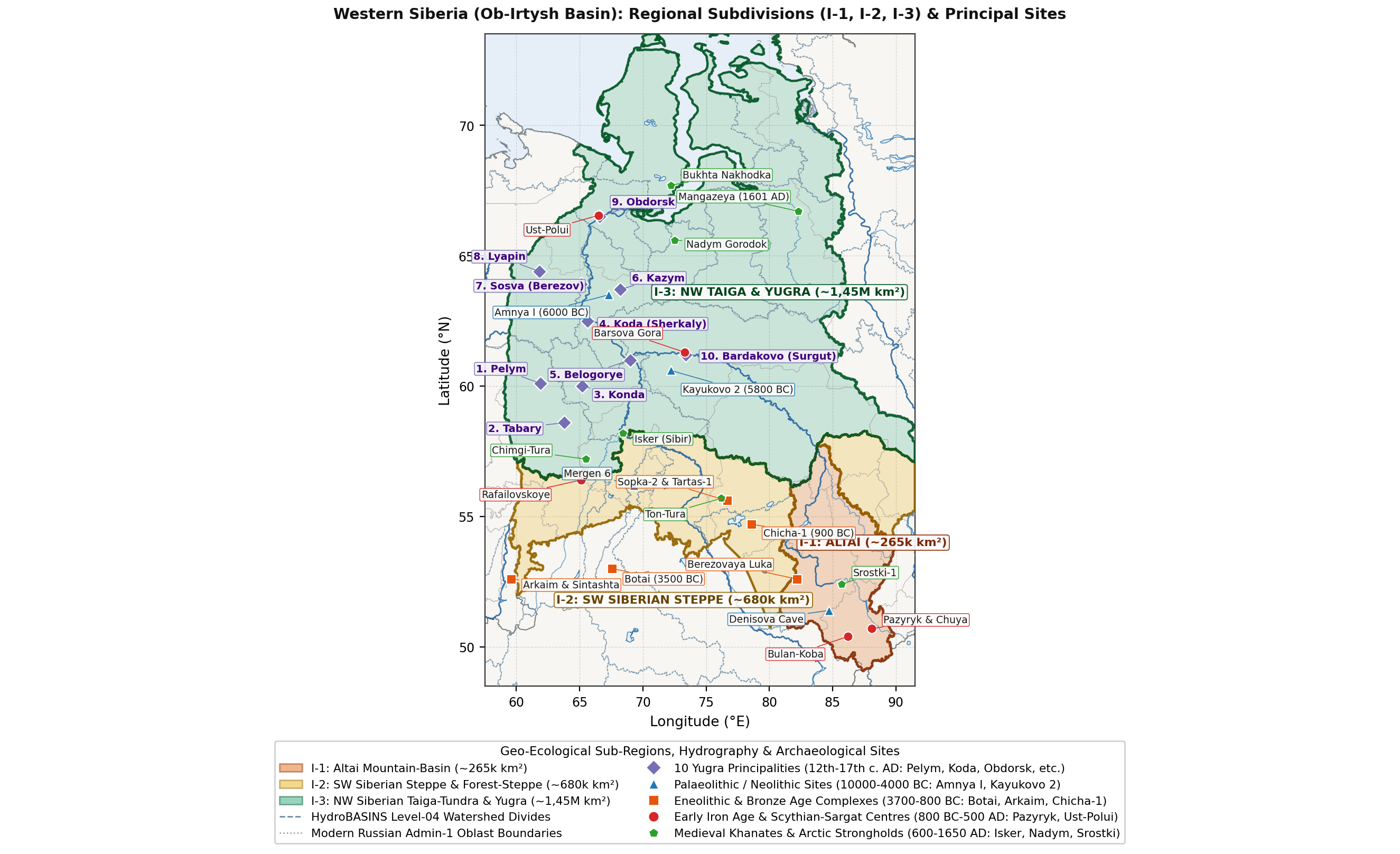
Stretching from the Ural watershed (58°E-60°E) to the Yenisei-Chulym divide (86°E-90°E) and from the intermontane valleys of the Russian Altai (49°N) to the Kara Sea coast (73°N), the Ob-Irtysh drainage basin forms the westernmost third of Siberia [1]. As shown in Figure 1, latitudinal climate belts and elevation gradients divide Western Siberia into three distinct environmental zones:
- Altai Region (I-1, ~265k km²; 49,0°N-54,0°N, 80,0°E-90,0°E): Covering the high intermontane valleys of the Mountain Altai (Gorny Altai - the Katun, Biya, Chuya, Argut, Ursul, Chulyshman, Bukhtarma, Ukok, and Anui/Denisova valleys) and the northern forest-steppe foothills (Altaiskoye Priobye - the Charysh, Alei, Inya, and Chumysh valleys). Rich in sheltered winter pastures and polymetallic copper-tin ores, the Altai supported early pastoralist settlement during the Eneolithic (Afanasievo culture), horse-riding polities during the Scythian (Pazyryk), Hunno-Sarmatian (Bulan-Koba), and Turkic (Srostki) periods, and rapid mining and agricultural expansion under the Kolyvano-Voskresensk (Altai) Mining District in the 18th and 19th centuries [8][9][10][11].
- South-West Siberian Steppe and Forest-Steppe (I-2, ~680k km²; 52,0°N-57,5°N, 61,0°E-86,0°E): Spanning the Southern Trans-Urals and Tobol-Ishim interfluve (the Tura, Pyshma, Iset, Miass, Tobol, Ubagan, and Ishim rivers), the Middle Irtysh (Tara, Om, and Osha rivers), the Baraba forest-steppe (Tartas and Kargat rivers, Lakes Chany and Sartlan), and the Kulunda steppe [12][13][14]. This chernozem and meadow-steppe belt supported Eneolithic horse-hunters (Botai-Tersek), Middle Bronze Age fortified settlements (Sintashta-Petrovka), Late Bronze Age fortified towns (Chicha-1), Early Iron Age chiefdoms (Sargat culture), the Late Medieval Tyumen and Siberian Khanates, and the primary corridor of Russian peasant colonisation along the Siberian Tract and Trans-Siberian Railway [5][15][16][17][18][19].
- North-West Siberian Taiga, Tundra, and Yugra (I-3, ~1,45M km²; 57,5°N-73,0°N, 58,0°E-86,0°E): Encompassing the boreal forest, wetlands, and Arctic tundra of the Lower and Middle Ob (Surgut, Berezov, and Obdorsk reaches), the Lower Irtysh (Demyanka and Konda basins), the eastern Ural tributaries (Tavda, Pelym, Lozva, Northern Sosva, Lyapin, and Voikar), and the right-bank Arctic rivers (Vakh, Trom-Yugan, Pim, Kazym, Polui, Nadym, Pur, Taz, and Yamal) [20][21]. Abundant seasonal runs of whitefish and sturgeon alongside migrating elk and reindeer herds sustained early fortified fishing settlements in the Neolithic (Amnya I and Kayukovo 2, c. 6000 cal BC), Iron Age metalworking centres (Barsova Gora, Ust-Polui, and the Kulai culture), and ten hereditary Ob-Ugrian (Khanty and Mansi) principalities (knyazhestva) documented in 16th- and 17th-century Russian records [2][3][22][23].
Methodology
Regional population estimates in this paper are built from three primary lines of evidence: excavated dwelling floor areas, skeletal mortality profiles from cemeteries, and historical tax and census records1.
House Counts and Settlement Area
- Boreal Taiga Pit-Houses (Poluzemlyanki, I-3): Excavations of Early Neolithic (Amnya I, Kayukovo 2), Bronze Age (Barsova Gora), and Iron Age (Beloyarskaya, Kulai, Karym) settlements by V. A. Borzunov [20][24][25], E. N. Dubovtseva [26][27], O. V. Kardash [23], and H. Piezonka [22][28] identify two main house types:
- Single-Chamber Pit-Houses (15-45 m²): Occupied by nuclear or small extended families of 5-8 individuals (~4,5-5,5 m² of heated winter floor space per person).
- Multi-Hearth Communal Pit-Houses (60-160 m², e.g. Kayukovo 2, Barsov Gorodok): Occupied by kin groups of 12-25 individuals (2-4 hearth families).
- Medieval Ob-Ugrian Fortified Towns (Gorodishcha / Gorodki, 12th-17th c. AD): Excavations in permafrost at Nadym Gorodok [29], Ust-Voikary [30], Berezov / Sugmut-Vash [31], and Emder [32] reveal dense rows of surface log cabins (16-36 m², housing 5-7 persons each) inside timber ramparts (700-3 500 m²), surrounded by outer seasonal quarters (posad). Assuming an occupancy rate
across multi-phase house depressions and a mean household size , settlement population is calculated as:
- Steppe and Forest-Steppe Longhouses (I-2):
- Middle Bronze Age Sintashta-Petrovka Fortified Settlements (2100-1750 cal BC): Magnetometry surveys and excavations at Arkaim (60-67 houses), Kamennyi Ambar (46 houses), and Sintashta (35-42 houses) document radial or linear blocks of timber-and-turf row-houses measuring 110-220 m² each [16][33]. While early studies suggested 25-30 occupants per house, demographic and cemetery analyses by A. V. Epimakhov [34][35] and B. Hanks [36] show that roughly one-third of indoor floor area was used for winter stalling of young livestock, wells, and copper-smelting furnaces, indicating 10-15 persons per house and 450-950 permanent residents per fortified settlement.
- Early Iron Age Sargat Settlements (500BC - 400AD): N. P. Matveeva's [17][37] study of Middle Tobol and Iset settlements (Rafailovskoye, Pavlinovo, Bayevo) combines multi-room house floor areas (70-180 m²) with contemporary burial grounds (705 individuals across 43 cemeteries) to estimate an average household of 10,0-11,0 persons, with ordinary villages (selishcha) housing 250-360 residents and major fortified centres such as Rafailovskoye supporting 1 200-1 650 inhabitants.
Cemetery Mortality Estimates
In the mountain valleys of the Altai (I-1) and the open steppes of I-2, mobile pastoralist winter camps leave thin cultural layers, whereas burial mounds (kurgans) and flat cemeteries are well preserved. Following the standard Acsádi-Nemeskéri life-table formula as applied to Siberian skeletal series by N. P. Matveeva [37], A. V. Epimakhov [34], and N. N. Seregin [10]:
where life expectancy at birth
Tax Registers and Census Records
- 17th-Century Yasak Tribute Books (Yasachnye Knigi): Early Russian fiscal registers preserved in the Russian State Archive of Ancient Acts (RGADA, Fund 214, Sibirsky Prikaz) record headcounts of adult able-bodied indigenous male tribute payers (yasachnye lyudi, aged 18-50). Following B. O. Dolgikh [2], S. V. Bakhrushin [3], E. V. Perevalova [38], and Ya. G. Solodkin [39], total indigenous population is estimated using:
- Ob-Ugrian (Khanty and Mansi) Principalities (I-3): A multiplier of
per registered yasak payer (combining Dolgikh's base ratio of 4,0 with a 5-12% allowance for unregistered dependents and remote forest or tundra camps). - Siberian Tatars (Tobolsk, Tyumen, Turinsk, Tara, and Baraba Volosts, I-2): A multiplier of
applied to registered tribute-paying (yasachnye), military-service (sluzhilye), and Bukharan merchant (bukhartsy) men [2][18]. - Altai Teleuts, Telengits, and Northern Altaian Tributaries (I-1): A multiplier of
per tribute payer or armed horseman listed in Russian diplomatic reports (stateynye spiski) [2][40].
- 18th- and 19th-Century Poll-Tax Revisions (Revizii) and the 1897 Imperial Census: Between 1719 and 1858, the Russian state conducted ten Poll-Tax Revisions (revizskie skazki) enumerating taxable male "souls" (revizskie dushi) among Russian state peasants (gosudarstvennye krestyane), Cabinet mining peasants (pripisnye krestyane), townspeople, and Siberian yasak payers (re-registered under Major Ya. Shcherbachev's 1763 yasak commission) [4][5][11]. Total population from revision male counts is obtained by doubling male soul totals (incorporating female family members recorded from the 3rd Revision of 1762-1764 onwards) and adding non-taxable categories (Cossacks of the Siberian Host, regular troops, clergy, and exiled settlers) [4]. Finally, the First All-Russian Imperial Census of 28 January 1897 (Pervaya vseobshchaya perepis' naseleniya Rossiyskoy Imperii 1897 g.), analysed at the uezd and volost level by S. K. Patkanov [6], Z. A. Tychinskikh [7], E. A. Bryukhanova [41], and Yu. V. Semenov [42], provides direct household-level enumerations across Tobolsk Governorate, Tomsk Governorate (including the Altai Mining District), and Akmolinsk Oblast.
Altai Region
Final Palaeolithic, Mesolithic, and Afanasievo Settlement (10000 - 2500BC)
During the Younger Dryas and Early Holocene warming (10000-6000BC), the sheltered lower valleys of the Anui, Katun, Biya, and Charysh rivers served as refugia for hunting and fishing groups. Stratified cave and open-air sites at Denisova Cave (Holocene layers 0-8), Kaminnaya Cave, Ust-Karakol-1, Kara-Bom, and Tytkesken-2 (along the Middle Katun, where nine cultural layers span the Mesolithic to the Eneolithic) document a gradual shift from Final Palaeolithic blade hunters to semi-sedentary Mesolithic and Kuznetsk-Altai Neolithic riverine fisher-hunters living in pit-houses (16-28 m²) and using collective cemeteries (Ust-Isha, Solontsy-5, Itkul). Across the Altai region (I-1), population grew gradually from ~1,5k (1,2k-1,9k; 0,006 persons/km²) at 10000BC to ~4,0k at 6000BC and ~7,5k by 4000BC.
Around 3100-3050 cal BC, the Mountain Altai experienced a major economic and demographic shift with the arrival of the Afanasievo culture (Afanasievskaya kultura), established by Western Steppe (Yamnaya-related) pastoralists who introduced domesticated cattle, sheep, goats, and horses [8][43]. A series of more than 150 AMS radiocarbon dates compiled by A. V. Poliakov, S. V. Svyatko, and N. F. Stepanova [8] shows that Mountain Altai Afanasievo sites cluster between 3100 and 2800 cal BC, slightly earlier than the Minusinsk Basin sites (2900-2500 cal BC). Over 60 kurgan cemeteries (Elo-1/2, Balyktyul, Kurta-2, Nizhnyaya Sooru, Bike-1/3, Kuyum, Aragol, Karasu) containing more than 450 stone-ringed enclosures and 15+ seasonal settlements (Elo-Bashichi, Kara-Tenesh, Malyi Dugan; [43]) indicate ~6,0k-8,0k pastoralists in the mountain valleys alongside ~6,5k-8,8k Eneolithic Bolshoy Mys inhabitants in the northern foothills, bringing the total Altai population to ~13,5k (10,8k-16,8k; 0,051 persons/km²) at 3000BC.
Bronze Age Metallurgy and Farming Villages (2500 - 800BC)
During the Early and Middle Bronze Age (2200-1700 cal BC), settlement patterns differed between the high mountain valleys and the northern forest-steppe plains [44]:
- Karakol Culture (2200-1700 cal BC): Concentrated in the Ursul and Middle Katun valleys (Karakol, Besh-Ozek, Ozernoye) and known for stone-cist graves decorated with polychrome mineral paintings (~5,0k-7,5k mountain inhabitants).
- Elunino Culture (2200-1700 cal BC): Occupying the Upper Ob forest-steppe and the copper-tin mining foothills of the Rudny Altai [44][45]. At the settlement of Berezovaya Luka on the Alei River (excavated over >2 200 m²), S. P. Grushin documented permanent timber-frame dwellings (17-20 m²), bronze-casting workshops, and large herds of horses (36%), sheep and goats (37%), and cattle (27%). More than 80 Elunino settlements and cemeteries (Elunino-1, Teleutsky Vzvoz-1, Starodubtsevo) supported ~15,0k-21,0k agro-pastoralists, raising total I-1 population to ~23,0k (18,5k-28,5k) by 2000BC.
Between 1800 and 800 cal BC, Andronovo (Fedorovo) communities (Firsovo-XIV, Kytmanovo, Rubtsovsk) and Late Bronze Age Irmen (Irmenskaya kultura) villages (Blizhniye Elbany, Krasnaya Gorka, Kalistratiha, Plotinnaya) established dense chains of river-terrace settlements containing 8-15 large multi-hearth pit-houses (80-150 m² each, housing 100-200 residents per village). Regional population increased from ~34,0k at 1500BC to ~48,0k at 1000BC and ~55,0k (45,0k-66,0k; 0,208 persons/km²) by 800BC.
Scythian, Hunno-Sarmatian, and Medieval Periods (800BC - 1700AD)
- Scythian-Saka Period (550-200BC) - Pazyryk, Kara-Koba, and Bystryanka Cultures:
- Following the early Scythian Arzhan-Maiemir phase (850-550BC), nomadic pastoralism expanded across all elevation zones of the Altai. Between 1995 and 2014, joint surveys by Ghent University and Gorno-Altaisk State University led by J. Bourgeois and W. Gheyle [9] mapped ~1 250 km² of high mountain valleys (Chuya, Kuray, Yustyd, Sebÿstei, Kalanegir, Dzhazator) using satellite imagery and GPS ground checks, recording more than 4 800 surface monuments (3,8-6,5 monuments/km² in Yustyd and Sebÿstei), of which 45-55% (>2 200 kurgans) date to the Pazyryk and Kara-Koba phases.
- Across all habitable valleys of the Russian Altai (an estimated 18 000-25 000 Scythian kurgans built over 350 years, with
and elite kurgan representation ), the Mountain Altai Pazyryk population numbered ~22,0k-30,0k pastoralists, while the northern foothill Bystryanka, Kamen, and Staroaleika farming and herding groups supported ~42,0k-52,0k inhabitants, giving a combined Altai population of ~68,0k (56,0k-82,0k; 0,257 persons/km²) at 400BC.
- Hunno-Sarmatian and Migration Period (200BC - 500AD) - Bulan-Koba Culture:
- Synthesised by N. N. Seregin and S. S. Matrenin [10] from more than 750 excavated graves across 45+ cemeteries (Bulan-Koba IV, Yaloman II, Ust-Edigan, Belyi Bom II, Choburak-I, Dyalyan, Stepushka), the Bulan-Koba culture (200BC - 450AD) and northern foothill Maima communities maintained a regional population of ~64,0k at 1AD and ~62,0k at 400AD, marked by frequent weapon burials (~75% of adult males buried with composite bows, iron armour plates, and horses).
- Turkic Khaganates, Medieval Srostki Culture, and Teleut/Telengit Uluses (500 - 1700AD):
- As the core metalworking region of the First and Second Turkic Khaganates (Kudyrge, Katanda, and Kuray phases; ~70,0k by 800AD), the Altai reached its highest pre-modern population during the Srostki culture (Srostkinskaya kultura, 850-1050AD), linked to the eastern wing of the Kimak-Kipchak confederation [46]. Across more than 160 kurgan cemeteries (Srostki-1, Biyke, Filimonovo, Kamen-2, Shadrino) and 40+ foothill settlements combining horse herding with millet and barley cultivation, the regional population reached ~78,0k (64,0k-93,0k; 0,294 persons/km²) at 1000AD.
- After 13th- and 14th-century Mongol-era warfare and pasture shifts reduced regional numbers to ~56,0k by 1400AD, 17th-century Russian tribute records from Kuznetsk (founded 1618) and Tomsk (founded 1604) analysed by B. O. Dolgikh [2] and O. A. Mitko [40] document ~14,0k-18,0k Teleuts ("White Kalmyks" of Prince Abak) and Northern Altaian/Shor tributaries (Kumandins, Tubalars, Chelkans, Abintsy) in the Upper Ob and Biya basins alongside ~28,0k-36,0k Southern Altai Telengits and Uriankhai (dvoedantsy paying dual tribute across 24 Dzungar zaisanstvos), giving ~54,0k (45,0k-64,0k) in 1580AD and ~55,0k (including early Russian settlers around Kuznetsk) by 1700AD.
Imperial Mining District and Peasant Colonisation (1700 - 1900AD)
The demographic profile of the Altai changed dramatically after the founding of Biysk Fortress (1709), the construction of Akinfiy Demidov's Kolyvan (1727) and Barnaul (1739-1744) copper and silver smelters, and Empress Elizaveta Petrovna's 1747 decree transferring the Kolyvano-Voskresensk Mining District (Kolyvano-Voskresenskiy gorniy okrug) to the Imperial Cabinet [4][5][11]:
- 18th-Century Fortification Lines, Ascribed Peasants, and the 1756 Entry of Southern Altai Nomads:
- Protected by the Kolyvano-Kuznetsk Fortified Line along the Biya, Katun, and Charysh foothills, the Imperial Cabinet assigned tens of thousands of state peasants as ascribed mining peasants (pripisnye krestyane) who supplied charcoal, timber, and grain to the Barnaul, Pavlovsk, and Zmeinogorsk silver works, supplemented by exiled Old Believers ("Polyaki") settled in the Uba and Bukhtarma valleys [5].
- Following the Qing destruction of the Dzungar Khanate in 1755-1756, twelve Southern Altai zaisans petitioned for Russian protection under Empress Elizabeth's decree of 2 May 1756 [11]. Regulated by Major Ya. Shcherbachev's 1763 yasak commission and later codified into seven Altaian dyuchinas and twenty-four Kalmyk and Teleut volosts under M. M. Speransky's 1822 Statute on Indigenous Administration (Ustav ob upravlenii inorodtsev), the indigenous Altaian, Teleut, and Kumandin population stabilised at ~42,0k-48,0k [6][11]. Combined with rapidly growing Russian villages, total Altai population rose from ~95,0k (82,0k-108,0k) in 1750AD (2nd Revision) to ~185,0k (165,0k-205,0k; ~140k Russians and ~45k indigenous Altaians) by 1800AD (5th Revision, 1795) and ~340,0k (310,0k-370,0k) by 1850AD (9th Revision) [4].
- Post-1865 Cabinet Land Opening and the 1897 Imperial Census:
- Following the emancipation of Cabinet mining peasants in 1861 and the Imperial decree of 30 July 1865 opening the Altai Cabinet lands to peasant migration from European Russia [19], the fertile black-earth piedmont of the Upper Ob became the primary agricultural destination in Siberia.
- In the First All-Russian Imperial Census of 1897 [6][41][42], Biysk uezd recorded 337 007 inhabitants, Zmeinogorsk uezd 242 718, and the Upper Ob and foothill volosts of Barnaul uezd (584 100 across the entire uezd, with Barnaul city at 21 073 and Biysk city at 17 213) contributed ~240,0k-260,0k within the I-1 boundary, including 49 528 indigenous Turkic inhabitants enumerated by S. K. Patkanov (42 223 Altaians, Telengits, Kumandins, Tubalars, and Chelkans, plus 7 305 Teleuts) [6]. Including peasant arrivals between 1897 and 1900, the population of the Altai region (I-1) reached ~875,0k (820,0k-930,0k; 3,302 persons/km²) in 1900AD.
South-West Siberian Steppe and Forest-Steppe
Mesolithic, Neolithic, and Botai Horse-Hunters (10000 - 2500BC)
Pollen cores and radiocarbon series from the Tobol-Ishim interfluve (Oshukovskoye peatland, Lake Kyrtyma, Lake Mergen) studied by N. E. Ryabogina and V. A. Zakh [12][13] and from the Baraba forest-steppe studied by V. I. Molodin [14][47] show that Boreal and Atlantic warming (8500-5000BC) established birch-pine parklands and shallow fish-rich lakes across the 680k km² of I-2. From sparse Mesolithic hunting and fishing camps (Chernoozerye VIa, Kamyshnoye-1, Vengerovo-5, Tartas-3; ~3,8k at 10000BC), population grew during the Early and Late Neolithic (Koshkino, Boborykino, Koksharovsko-Yuryinskaya, and Ust-Tartas cultures; Mergen 6 with 20+ pit-houses of 20-50 m² and Vengerovo-2A) from ~11,0k (8,8k-13,8k) at 6000BC to ~21,0k (16,8k-26,0k) at 4000BC.
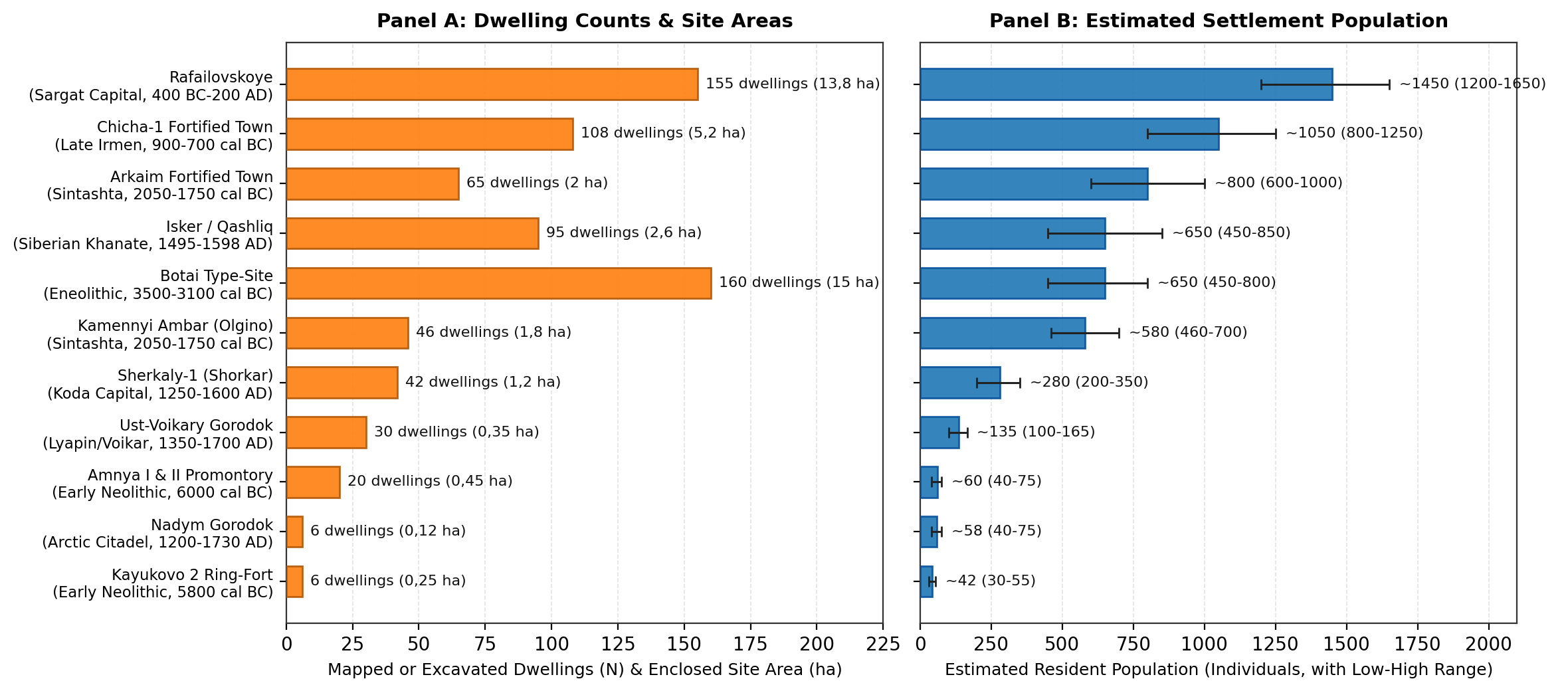
Between 3700 and 3100 cal BC, the southern Ishim-Tobol forest-steppe margin witnessed the growth of the Botai-Tersek culture, whose economy relied heavily (90-99% of animal bones) on horse hunting, taming, and mare's milk (koumiss) processing [15][48]. Fluxgate magnetometry surveys led by A. K. Outram and V. F. Zaibert [48] mapped 158-250+ polygonal pit-houses (20-70 m²) across 15 ha at the Botai type-site (~160 contemporaneous dwellings housing ~450-800 residents), 54 houses at Krasnyi Yar, and 44 houses at Vasilkovka IV, raising total I-2 population to ~35,0k (28,0k-43,5k; 0,051 persons/km²) by 3000BC.
Bronze Age Fortified Towns and Forest-Steppe Villages (2500 - 800BC)
- Early and Middle Bronze Age (2300-1750 cal BC) - Tashkovo, Odinovo-Krotovo, and Sintashta-Petrovka Settlements:
- In the Lower Tobol and Tura basin, circular Tashkovo-2 villages (11-13 timber houses of 35-48 m² arranged around a central open space, housing 70-100 residents) developed alongside the Odinovo and Krotovo cultures of the Middle Irtysh and Baraba (Sopka-2, Tartas-1 with >800 excavated graves, Vengerovo-2 with 60-110 m² houses containing indoor tin-bronze furnaces, and the Rostovka and Chernoozerye Seima-Turbino cemeteries; [14][47]).
- In the Southern Trans-Urals and Upper Tobol-Ui-Miass watershed, Sintashta-Petrovka (2100-1750 cal BC) pastoralists and copper smelters built more than 24 fortified circular and rectangular towns, including Arkaim (2,0 ha, 60-67 longhouses housing 600-1 000 residents), Kamennyi Ambar (1,8 ha, 46 longhouses of 150-220 m² housing 460-700 residents), Sintashta, Ustye, Stepnoye, Kuysak, Alabuga, and Petrovka-2 [16][33][34][35][36]. Combining the 24 fortified towns and surrounding hamlets (~15,0k-24,0k inhabitants) with Tashkovo and Odinovo-Krotovo communities across the Irtysh and Baraba plains gives a total I-2 population of ~62,0k (50,0k-76,0k; 0,091 persons/km²) at 2000BC.
- Late Bronze Age Expansion (1750-900BC) and the Fortified Town of Chicha-1 (900-700 cal BC):
- During the Andronovo (Alakul and Fedorovo) period (1750-1400BC) and the subsequent Cherkaskul, Pakhomovo, Suzgun, Barkhatovo, and Irmen cultures (1400-900BC), hundreds of unfortified river-terrace villages (5-20 large timber houses of 100-250 m² per village) spread across the Tobol, Ishim, Irtysh, and Baraba valleys, lifting I-2 population to ~86,0k at 1500BC and ~108,0k at 1000BC.
- Around 900-700 cal BC (Late Irmen transition), cooler, wetter conditions and contact with northern forest groups (Atlym and Suzgun) led to the construction of large fortified settlements in Baraba [49]. At Chicha-1 on Lake Malaya Chicha, Russian-German magnetometry and excavations directed by V. I. Molodin, H. Parzinger, and J. Schneeweiss [49] uncovered a 5,2 ha fortified town divided by concentric ditches and ramparts into an inner citadel (Zone I) and three outer residential quarters (Zones II-IV) containing 100-110+ contemporaneous pit and timber-frame houses (40-120 m² each), supporting ~800-1 250 inhabitants (mean ~1 050). Regional population in I-2 reached ~118,0k (96,0k-142,0k) at 800BC.
Early Iron Age Sargat Confederacy and Siberian Khanate (800BC - 1700AD)
- The Sargat Culture (Sargatskaya kultura, 500BC - 400AD):
- Covering more than 400k km² across the Tobol, Iset, Pyshma, Ishim, Middle Irtysh, and Baraba forest-steppe, the Sargat culture formed the largest pre-modern population in Western Siberia, widely associated with Ugrian and Iranian mounted pastoralists and forest-steppe farmers [17][37][50].
- More than 500 known Sargat sites (~80 fortified gorodishcha, ~300 unfortified villages, and ~150 kurgan cemeteries) form a three-level settlement hierarchy reconstructed by N. P. Matveeva [17][37]:
- Major Fortified Centres: Rafailovskoye on the Iset (a 1,8 ha multi-rampart citadel plus a 12,0 ha outer settlement containing ~155 contemporaneous multi-room houses and supporting 1 200-1 650 residents; [50]), Pavlinovo, Aktau, Inbereny-IV, Sargatskoye, Bayevo, and Abramovo-4.
- Ordinary Fortified Refuges and Villages: 25-35 active households of 10,0-11,0 persons each, or 250-360 residents per settlement cluster.
- Seasonal Herding Camps: 5-10 households (50-100 persons).
- Combining mortality data from 43 Sargat cemeteries (705 individuals; adult life expectancy
, mean adult age at death 36,5 years; [37]) with settlement counts across the Tobol-Irtysh river valleys yields an estimated I-2 population of ~136,0k (112,0k-162,0k; 0,200 persons/km²) at 400BC and ~138,0k (114,0k-165,0k) at 1AD, declining to ~112,0k by 400AD during the Migration Period.
- Medieval Forest-Steppe Polities and the Siberian Khanate (600 - 1700AD):
- Between 600 and 1240AD, Bakalskaya (Tobol-Iset), Yudino (Tura-Tavda), and Ust-Ishim (Middle Irtysh) communities interacted with the Kimak-Kipchak Khaganate (whose main seat on the Middle Irtysh is mentioned by medieval Islamic geographers) and Cuman-Kipchak tribes, sustaining ~118,0k inhabitants at 800AD, ~126,0k at 1000AD, and ~120,0k at 1200AD.
- Under the Ulus of Jochi (the Shibanid appanage and the local Taibugid rulers), 14th-century political fragmentation and plague reduced the I-2 population to ~92,0k by 1400AD. In the 15th and 16th centuries, the region reorganised under the Tyumen Khanate (centred at Chimgi-Tura, modern Tyumen) and the Siberian Khanate (c. 1495-1598AD) ruled by the Taibugids and the Shibanid Khan Kuchum (r. 1563-1598) [18][51][52].
- Excavations of the Khanate's 65+ fortified settlements (gorodishcha) synthesised by A. P. Zykov, S. F. Tataurov, and D. N. Maslyuzhenko [18][52] show that the capital Isker (Qashliq / Gorod Sibir) occupied a 2,0-2,6 ha triple-rampart promontory citadel with an outer settlement (~95 structures) housing 450-850 permanent residents (rising to 2 000-3 500 during military musters), flanked by regional administrative forts at Chimgi-Tura (500-1 000 residents), Suzgun, Chuvashsky Mys, Karachin Gorodok, Kullara, Kyzyl-Tura, and Ton-Tura (Voznesenskoye on the Om River in Baraba, 300-600 residents).
- Based on the earliest Russian yasak and service-Tatar registers (1590s-1630s) compiled by B. O. Dolgikh [2], the indigenous population of the Siberian Khanate's core territory in c. 1580AD numbered ~34,3k-44,3k (mean ~39,3k: ~9,5k-11,0k Tobolsk and Vagay Tatars, ~5,8k-6,8k Tyumen and Tura Tatars and Southern Mansi, ~3,2k-4,0k Tara and Middle Irtysh Tatars, ~3,8k-4,5k Baraba Tatars, and ~12,0k-18,0k Ishim-Kulunda nomadic subjects), within a total I-2 population of ~88,0k (72,0k-105,0k) including southern Kazakh and Kalmyk steppe camps.
- Following the founding of Tyumen (1586), Tobolsk (1587), Tara (1594), Turinsk (1600), Yalutorovsk (1659), and Shadrinsk (1662), Russian peasant (pashennye krestyane) and Cossack settlement across the Tura, Pyshma, Iset, and Tobol valleys added ~145,0k Russian inhabitants by the 1701 Tobolsk census alongside ~43,0k Siberian Tatars, Bukharans, and southern pastoralists, bringing I-2 population to ~134,0k in 1650AD and ~188,0k (172,0k-204,0k; 0,276 persons/km²) by 1700AD.
Fortified Lines, Poll-Tax Revisions, and the Trans-Siberian Railway (1700 - 1900AD)
Throughout the 18th and 19th centuries, the South-West Siberian forest-steppe served as the main gateway for Russian agricultural settlement in Asia [4][5][19]:
- The 18th-Century Fortified Lines and Poll-Tax Revisions (1700 - 1850AD):
- Following I. D. Bukhgolts's founding of Omsk Fortress (1716) and the construction of the Irtysh and Novo-Ishimskaya fortification lines (Presnogorkovskaya - Petropavlovskaya - Omskaya, 1730s-1752), Russian military and peasant settlement pushed southward from the Tobol-Tura river valleys onto the open chernozem plains of Kurgan, Ishim, Omsk, and the Baraba Siberian Tract (Sibirskiy trakt) [5].
- According to V. M. Kabuzan's [4] and A. D. Kolesnikov's [5] analyses of the 1st through 10th Poll-Tax Revisions, the population of I-2 nearly doubled every half-century: rising from ~188,0k in 1700AD to ~340,0k (305,0k-375,0k) in 1750AD (2nd Revision, 1744-1747), ~640,0k (585,0k-695,0k) in 1800AD (5th Revision, 1795), and ~1 180,0k (1,09M-1,27M; 1,735 persons/km²) in 1850AD (9th Revision). Alongside Russian state peasants and Cossacks of the Siberian Line Host, the indigenous and resettled Turkic population (Tobolsk, Tyumen, Tara, and Baraba Tatars, Central Asian Bukhartsy, and Volga-Ural Tatar settlers) expanded from ~43,0k in 1700AD to ~52,0k in 1795 and ~64,0k by the 10th Revision of 1858 [7][53].
- Post-Emancipation Peasant Resettlement, the Trans-Siberian Railway, and the 1897 Census (1850 - 1900AD):
- After the 1861 peasant emancipation, the 1889 Resettlement Law, and the construction of the West Siberian section of the Trans-Siberian Railway (Chelyabinsk - Kurgan - Petropavlovsk - Omsk - Kainsk - Ob, 1892-1896), state-assisted peasant migration into the Tobol, Ishim, and Baraba steppes accelerated sharply [19][54].
- In the 1897 Imperial Census [6][7][41][42], the eight southern forest-steppe uezds of Tobolsk Governorate recorded 1 403 837 inhabitants (Ishim uezd 269 031, Kurgan 260 095, Tyukalinsk 208 718, Yalutorovsk 188 550, Tara 159 655, Tobolsk 127 860, Tyumen 121 357, and Turinsk 68 571, including 56 957 Tatars and Bukharans in Tobolsk Governorate [7][53]), while Kainsk uezd (187 147) and the northern Baraba-Kulunda volosts of Tomsk Governorate added ~512,0k, and the northern forest-steppe districts of Akmolinsk Oblast (Petropavlovsk uezd 227 539, Omsk uezd 100 539 with Omsk city at 37 376, and adjoining Ishim-Irtysh volosts) accounted for ~580,0k-620,0k residents. Including railway-corridor arrivals between 1897 and 1900, the total population of I-2 reached ~2 650,0k (2,50M-2,80M; 3,897 persons/km²) in 1900AD.
North-West Siberian Taiga, Tundra, and Yugra
Early Neolithic Fortified Settlements: Amnya I and Kayukovo 2 (10000 - 4000BC)
As post-glacial forests established across the Lower Ob and Konda-Sosva basins, Mesolithic hunter-fishers occupied elevated pine-covered river terraces (Lugovskoye, Sumpanya-IV/VI, Korstovo, Komudvany; ~2,0k across 1,45M km² at 10000BC, rising to ~3,2k at 8000BC). Around 6100-5500 cal BC, Early Neolithic communities in the West Siberian taiga began building fortified promontory settlements (260-1 900 m²) enclosed by timber palisades, earthen banks, and ditches, as documented by V. A. Borzunov [20][25], E. N. Dubovtseva [26][27], O. V. Kardash [23], and H. Piezonka [22][28]:
- Amnya I and Amnya II (Kazym River Basin, 63,5°N): AMS radiocarbon dating published by H. Piezonka, N. M. Chairkina, E. N. Dubovtseva, and L. L. Kosinskaya [22][26] dates the inner defensive ditch, rampart, palisade, and House 1 to 6100-5900 cal BC, making Amnya I the oldest dated fortified settlement in northern Eurasia. The site consists of 10 semi-subterranean pit-houses (15-40 m², 0,6-1,8 m deep) behind three defensive ditch-and-bank lines (Amnya I), together with 10 unfortified outer pit-houses (Amnya II) 50 m to the east, housing ~40-75 residents (mean ~60) who controlled seasonal fish-weir (zapor) and elk-crossing sites.
- Kayukovo 2 (Bolshoy Salym - Bolshoy Yugan Watershed): Excavated by O. V. Kardash, N. M. Chairkina, E. N. Dubovtseva, and H. Piezonka [23] and AMS-dated to 6000-5500 cal BC. This circular fortified settlement (35 x 35 m, ~1 150 m² inner enclosure within a 0,25 ha site) was surrounded by a timber wall and ring ditch and contained 5 outer pit-houses (16-32 m²) linked by sunken passages to a central communal building (House 6), housing ~30-55 residents (mean ~42).
- Together with Imnegan, Sumpanya IV/VI, and Et-to I/II (on the Nadym-Pur watershed at 63,2°N), more than 300 Neolithic pit-house sites across I-3 supported ~5,8k (4,6k-7,2k) inhabitants at 6000BC and ~8,8k (7,0k-11,0k) by 4000BC.
Eneolithic, Bronze Age, and Iron Age Centres (4000BC - 600AD)
- Eneolithic and Bronze Age (4000-800BC) - Sartyn'ya, Seima-Turbino, Atlym, and Barsova Gora:
- Eneolithic comb-pit pottery groups (Sartyn'ya, Shapkul, Chuovsky) living in multi-hearth winter pit-houses (40-90 m²) supported ~10,8k inhabitants at 3000BC. During the Seima-Turbino period (2150-1900 cal BC; Satyga XVI sanctuary) and the Late Bronze Age Atlym culture (1200-800BC), large semi-subterranean houses (50-120 m²) spread north to the Arctic Circle, raising I-3 population from ~12,8k at 2000BC to ~15,5k at 1000BC.
- Along an 8 km bluff on the right bank of the Middle Ob near Surgut, the Barsova Gora complex studied by Yu. P. Chemyakin and A. P. Zykov [55][56] preserves 66 fortified settlements (gorodishcha), ~300 unfortified villages (selishcha), 8 ritual sites, and ~3 000 house depressions spanning 7 000 years from the Neolithic to the 17th century AD.
- Early Iron Age and Migration Period (800BC - 600AD) - Beloyarskaya, Kulai, Ust-Polui, and Karym Cultures:
- Between 500BC and 450AD, the Kulai culture (Kulaiskaya kultura) spread across the Middle and Lower Ob (Sarovskoye, Barsov Gorodok I/32; [56]).
- At Ust-Polui (260BC - 140AD, on the Polui River cape in modern Salekhard at 66,5°N), excavations by N. V. Fedorova, A. V. Gusev, R. J. Losey, and E. V. Vodyasov [57][58][59][60] uncovered a ditch-and-palisade sanctuary and metalworking site (~4 200 m²) containing the earliest evidence of iron smelting and forging in the Arctic [57][58], carved bone harness toggles for reindeer sleds [60], and the remains of more than 115 domesticated sledging and sacrificial dogs [59]. During the subsequent Karym phase (350-550AD) studied by V. A. Borzunov and Yu. P. Chemyakin [24], fortified taiga settlements multiplied along the Surgut and Lower Ob rivers, with regional population growing from ~17,2k at 400BC to ~18,0k at 1AD and ~18,6k at 400AD.
Medieval Yugra and the Ten Ob-Ugrian Principalities (600 - 1700AD)
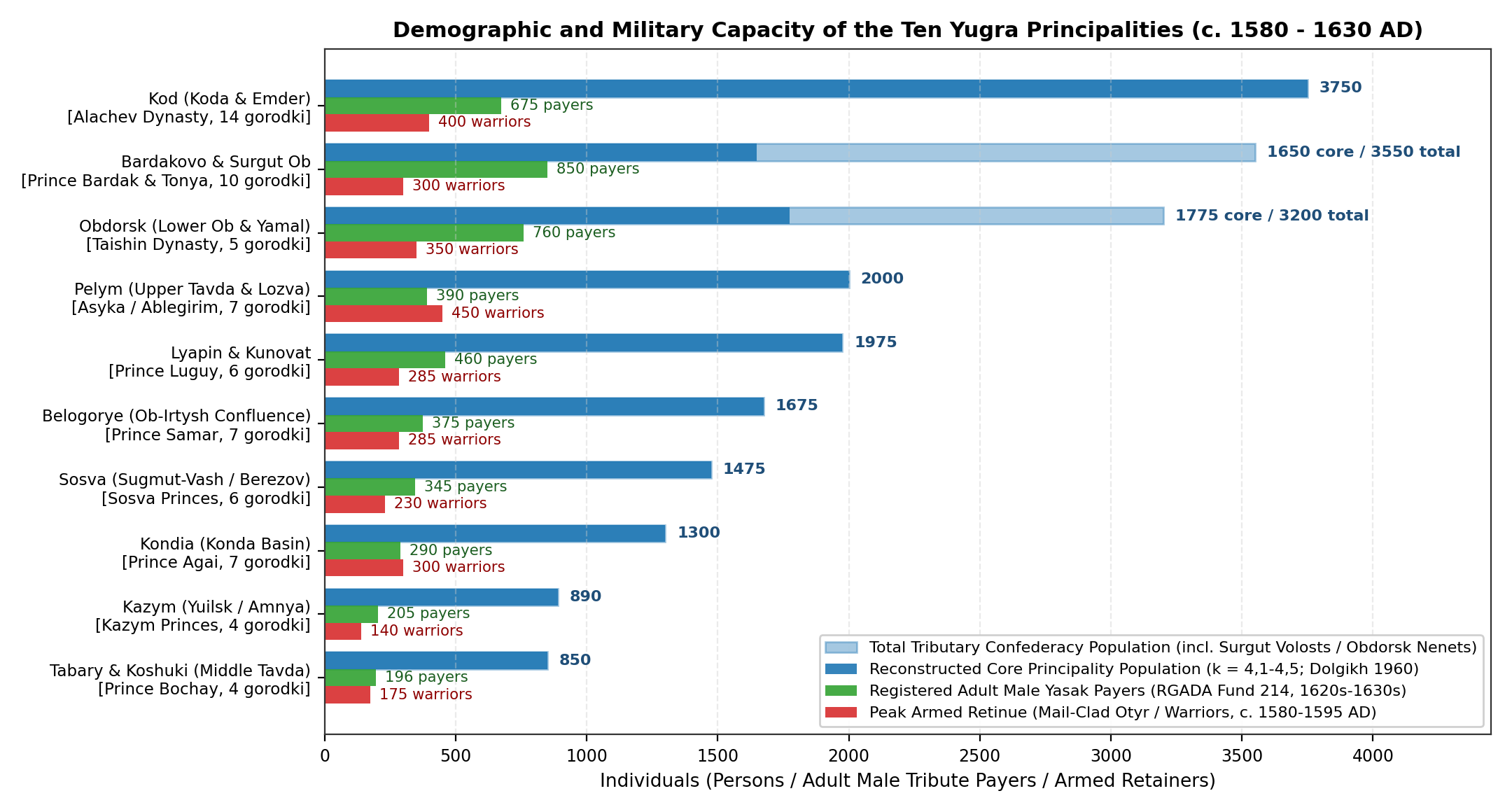
Between the 8th and 16th centuries AD (Lower Ob culture: Kintusovskiy, Oronturskiy, Emder, and Saygatinskiy stages; [32][55]), trade in northern furs with Volga Bulgaria, Great Novgorod (recorded in Gyuryata Rogovich's 1096AD account and the Novgorodian expeditions of 1187 and 1193), and the Golden Horde supported the rise of ten hereditary Ob-Ugrian (Mansi/Vogul and Khanty/Ostyak) principalities (knyazhestva) [2][3][38][39][61]. Analysis of 25 871 fish bones from 17 Late Holocene sites (Nadym Gorodok, Ust-Voikary, Sherkaly-1, Bukhta Nakhodka, Berezov) by T. V. Lobanova and D. O. Gimranov [21] confirms that large-scale seasonal catching and drying (yukola) of pike, ide, sturgeon, nelma, and muksun supplied the food stores needed for permanent fortified timber towns (gorodki):
- Sherkaly-1 (Shorkarskiy Gorodok, Koda Principality): Three fortified hill enclosures (~1,2 ha) with 40+ surface log cabins fitted with stone ovens (pechi-kamenki) and smithies (~200-350 residents; [55]).
- Emder (Endyrskoye-1): Nine successive building layers (11th-16th c. AD, ~2 400 m² citadel and outer settlement, ~120-220 residents; [32]).
- Ust-Voikary (Voikarsky Gorodok) and Berezov (Sugmut-Vash): Permafrost-preserved log towns containing ~30 residential and storage buildings (~100-165 residents; [30][31]).
- Nadym Gorodok (1200-1730AD, a 700 m² timber fort of the Bolshaya Karacheya clan with 6 log apartment blocks housing 40-75 winter residents; [29]) and Bukhta Nakhodka (1213-1332AD tree-ring dated Arctic Sikhirtya coastal fort on the Yamal Peninsula, 25-45 residents).
| No. | Principality | Ethnic Group | Ruling Dynasty | Main Fortified Towns (N) | Adult Male Yasak Payers | Armed Warriors | Estimated Pop. (k = 4,1-4,5) |
|---|---|---|---|---|---|---|---|
| 1 | Pelym (Pelymskoe) | Western Mansi (Voguls) | Asyka, Yumshan, Ablegirim | Pelym, Ust-Lozva, Vagil (7) | 365-410 | 400-500 | 1 800-2 200 |
| 2 | Tabary & Koshuki | Southern Plough Mansi | Prince Bochay (Tabary) | Tabary, Koshuki, Chubarov (4) | 177-215 | 150-200 | 750-950 |
| 3 | Kondia (Kondinskoe) | Konda Mansi & Khanty | Prince Agai / Kondinsky | Kartauzh, Levushi, Satyga (7) | 235-340 | 250-350 | 1 100-1 500 |
| 4 | Kod (Koda & Emder) | Middle-Lower Ob Khanty | House of Alachev (Moldan, Igichey) | Koda, Shorkar, Vezhakar, Emder (14) | 620-730 | 350-450 | 3 000-4 500 |
| 5 | Belogorye (Ob-Irtysh) | Confluence Khanty | Prince Samar (d. 1582) | Samarovo, Belogorye, Tsingaly (7) | 340-410 | 250-320 | 1 500-1 850 |
| 6 | Kazym (Kazymskoe) | Northern Khanty & Nenets | Kazym / Moldanov Princes | Yuilsk, Polnovat, Amnya (4) | 185-220 | 120-160 | 800-980 |
| 7 | Sosva (Sugmut-Vash) | Northern Mansi & Khanty | Sosva Princes (Berezov) | Sugmut-Vash, Iskar, Sartyn'ya (6) | 320-370 | 200-260 | 1 350-1 600 |
| 8 | Lyapin & Kunovat | Sygva Mansi & Khanty | Luguyev Dynasty (Luguy, Shatrov) | Lombovozh, Lopmus, Ust-Voikary (6) | 430-490 | 250-320 | 1 800-2 150 |
| 9 | Obdorsk (Pulnovat-Vash) | Arctic Khanty & Nenets | House of Taishin (Vasily, Mamruk) | Pulnovat-Vash, Sobsky, Muzhi (5) | 380-450 (760 w/ Nenets) | 300-400 | 1 775 (3 200 w/ Nenets) |
| 10 | Bardakovo & Surgut Ob | Eastern (Surgut) Khanty | Prince Bardak & Prince Tonya | Bardakov, Monkys-Uriy, Pim (10) | 390 Core (850 All Surgut) | 250-350 | 1 650 (3 550 All Surgut) |
| - | Unattached Tura/Nadym/Taz | Tura Mansi & Taz Nenets | Bolshaya Karacheya & Tura Murzy | Nadym Gorodok, Tura Yurts (5) | 550-680 | 200-300 | 2 300-2 900 |
| Total | All Yugra & NW Taiga (I-3) | Khanty, Mansi & Nenets | 10 Hereditary Princely Houses | ~65-75 Active Fortified Gorodki | 4 680-5 410 | 2 720-3 610 | 19 350-23 880 (Mean 21,5k) |
As shown in Table 1 and Figure 2, summing across all ten principalities and neighbouring Tura Mansi and Nadym/Taz Nenets districts gives 16 050-19 800 Ob-Ugrians (~9,8k Khanty and ~6,4k Mansi) plus ~2 800-3 800 North-West Siberian Tundra and Forest Nenets (Samoyeds) in 1580-1625AD, matching B. O. Dolgikh's [2] estimate of ~21,5k (19,35k-23,88k) indigenous inhabitants across I-3 (rising to ~26,0k by 1700AD when ~4,5k Russian Cossacks and townsmen in Berezov, Surgut, Pelym, Obdorsk, and Mangazeya are included).
Berezov and Surgut Districts in the 18th and 19th Centuries (1700 - 1900AD)
During the 18th and 19th centuries, the northern forest and tundra basins of the Lower and Middle Ob were administered primarily through Berezov and Surgut okrugs (uezds) of Tobolsk Governorate, alongside the northern volosts of Turinsk (Pelym) and Verkhoturye [4][6][62]:
- Orthodox Christianisation, Abandonment of Fortified Gorodki, and Poll-Tax Revisions (1700 - 1850AD):
- Following Peter I's decrees of 1706-1714 and the missionary expeditions of Metropolitan Filofey (Leshchinsky) between 1712 and 1727 [62], most Khanty and Mansi river communities were formally baptised, and the old fortified princely gorodki (such as Nadym Gorodok, abandoned c. 1730; [29]) gave way to open winter log-cabin villages (zimovya) and seasonal birch-bark fishing camps (yurts). In Obdorsk, however, the hereditary Taishin princes retained formal administrative authority over Lower Ob Khanty and Yamal Nenets yasak collection until 1886 [38][61].
- Across the 2nd (1744-1747), 5th (1795), and 9th (1850) Revisions [4][62], slow growth among northern Khanty and Tundra Nenets reindeer herders offset gradual linguistic assimilation of southern Mansi and Konda villages into surrounding Russian peasant parishes, lifting total I-3 population from ~26,0k in 1700AD to ~28,0k in 1750AD, ~30,0k in 1800AD, and ~32,0k in 1850AD.
- The 1897 Imperial Census Across Berezov, Surgut, and Pelym (1900AD):
- In the First All-Russian Imperial Census of 1897, analysed in detail at the volost and clan level by S. K. Patkanov [6], the complete okrug tally for Berezov Okrug (including nomadic Yamal and Kazym tundra volosts beyond the 11 406 stationary residents) recorded 21 411 inhabitants (72,9% indigenous Khanty, Mansi, and Nenets, alongside Russian townsmen in Berezov [1 070] and Obdorsk and migrant Izhma Komi-Zyrian reindeer herders), while Surgut Okrug recorded 7 747 inhabitants (72,1% indigenous Khanty and Forest Nenets, with 1 120 residents in Surgut town).
- Including the Ob-Ugrian and Selkup volosts of northern Tobolsk (Samarovo), Turinsk (Pelym and Konda), and the Upper Taz [6][63], the 1897 Census enumerated 19 663 Khanty (Ostyaks), 7 651 Mansi (Voguls), and ~4 450 West Siberian Tundra and Forest Nenets (Samoyeds) (~31 764 indigenous inhabitants across I-3), together with ~3 200 Russians and Komi-Zyrians, giving a total I-3 population of ~35,0k (32,0k-38,0k; 0,024 persons/km²) in 1900AD.
Population Estimates
Combining the excavated settlement data (Figure 3 and Table 3), cemetery mortality profiles, 17th-century yasak registers, 18th- and 19th-century Poll-Tax Revisions, and the 1897 Imperial Census across I-1, I-2, and I-3 produces the regional population and density estimates from 10000BC to 1900AD shown in Figure 4 and Table 2.
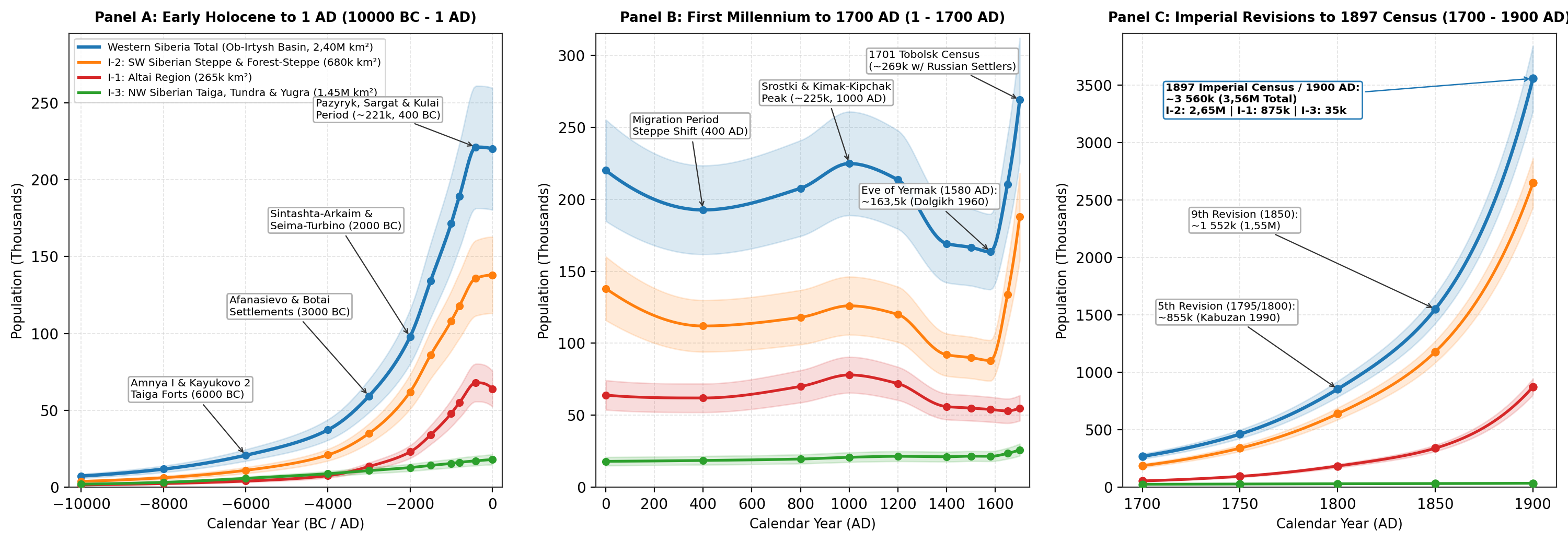
| Date | I-1 Altai Pop. (265k km²) | I-1 Dens. | I-2 Steppe Pop. (680k km²) | I-2 Dens. | I-3 Taiga/Yugra Pop. (1,45M km²) | I-3 Dens. | Western Siberia Total (2,40M km²) | Main Cultural or Historical Period |
|---|---|---|---|---|---|---|---|---|
| 10000BC | 1 500 (1,2k-1,9k) | 0,006 | 3 800 (3,0k-4,8k) | 0,006 | 2 000 (1,5k-2,6k) | 0,001 | 7 300 (5,7k-9,3k) | Final Palaeolithic / Early Mesolithic (Denisova, Chernoozerye) |
| 8000BC | 2 400 (1,9k-3,0k) | 0,009 | 6 200 (4,9k-7,8k) | 0,009 | 3 200 (2,5k-4,1k) | 0,002 | 11 800 (9,3k-14,9k) | Boreal Mesolithic Hunter-Fishers (Kaminnaya, Sumpanya, Vengerovo-5) |
| 6000BC | 4 000 (3,2k-5,0k) | 0,015 | 11 000 (8,8k-13,8k) | 0,016 | 5 800 (4,6k-7,2k) | 0,004 | 20 800 (16,6k-26,0k) | Early Neolithic Fortified Sites (Amnya I, Kayukovo 2, Koshkino) |
| 4000BC | 7 500 (6,0k-9,4k) | 0,028 | 21 000 (16,8k-26,0k) | 0,031 | 8 800 (7,0k-11,0k) | 0,006 | 37 300 (29,8k-46,4k) | Late Neolithic / Early Eneolithic (Boborykino, Ust-Tartas) |
| 3000BC | 13 500 (10,8k-16,8k) | 0,051 | 35 000 (28,0k-43,5k) | 0,051 | 10 800 (8,6k-13,5k) | 0,007 | 59 300 (47,4k-73,8k) | Afanasievo Pastoralists (I-1) & Botai Horse Villages (I-2) |
| 2000BC | 23 000 (18,5k-28,5k) | 0,087 | 62 000 (50,0k-76,0k) | 0,091 | 12 800 (10,2k-15,8k) | 0,009 | 97 800 (78,7k-120,3k) | Sintashta-Arkaim Forts, Elunino, Krotovo & Seima-Turbino |
| 1500BC | 34 000 (27,5k-41,5k) | 0,128 | 86 000 (70,0k-105,0k) | 0,126 | 14 200 (11,5k-17,5k) | 0,010 | 134 200 (109,0k-164,0k) | Andronovo (Alakul & Fedorovo) Farming & Herding Expansion |
| 1000BC | 48 000 (39,0k-58,0k) | 0,181 | 108 000 (88,0k-130,0k) | 0,159 | 15 500 (12,6k-19,0k) | 0,011 | 171 500 (139,6k-207,0k) | Late Bronze Irmen, Suzgun, Barkhatovo, Atlym & Barsova Gora |
| 800BC | 55 000 (45,0k-66,0k) | 0,208 | 118 000 (96,0k-142,0k) | 0,174 | 16 200 (13,2k-19,8k) | 0,011 | 189 200 (154,2k-227,8k) | Chicha-1 Fortified Town (108 Houses) & Early Scythian Period |
| 400BC | 68 000 (56,0k-82,0k) | 0,257 | 136 000 (112,0k-162,0k) | 0,200 | 17 200 (14,0k-21,0k) | 0,012 | 221 200 (182,0k-265,0k) | Pazyryk Culture (I-1), Sargat Confederacy (I-2), Kulai (I-3) |
| 1AD | 64 000 (52,0k-77,0k) | 0,242 | 138 000 (114,0k-165,0k) | 0,203 | 18 000 (14,8k-21,8k) | 0,012 | 220 000 (180,8k-263,8k) | Bulan-Koba (I-1), Late Sargat (Rafailovskoye), Ust-Polui (I-3) |
| 400AD | 62 000 (50,0k-75,0k) | 0,234 | 112 000 (92,0k-134,0k) | 0,165 | 18 600 (15,2k-22,5k) | 0,013 | 192 600 (157,2k-231,5k) | Migration Period (Choburak-I / Dyalyan, Potchevash, Karym) |
| 800AD | 70 000 (58,0k-84,0k) | 0,264 | 118 000 (96,0k-142,0k) | 0,174 | 19 600 (16,0k-23,5k) | 0,014 | 207 600 (170,0k-249,5k) | First & Second Turkic Khaganates, Early Kimak & Kintusovskiy |
| 1000AD | 78 000 (64,0k-93,0k) | 0,294 | 126 000 (104,0k-150,0k) | 0,185 | 20 800 (17,0k-25,0k) | 0,014 | 224 800 (185,0k-268,0k) | Srostki Culture & Kimak-Kipchak Peak; Early Yugra Gorodki |
| 1200AD | 72 000 (59,0k-86,0k) | 0,272 | 120 000 (98,0k-144,0k) | 0,176 | 21 500 (17,8k-25,6k) | 0,015 | 213 500 (174,8k-255,6k) | Cuman-Kipchak, Bakalskaya, Ust-Ishim, Sherkaly-1 & Emder |
| 1400AD | 56 000 (46,0k-67,0k) | 0,211 | 92 000 (75,0k-110,0k) | 0,135 | 21 200 (17,5k-25,2k) | 0,015 | 169 200 (138,5k-202,2k) | Ulus of Jochi/Shiban Steppe Contraction; Bukhta Nakhodka |
| 1500AD | 55 000 (45,0k-66,0k) | 0,208 | 90 000 (74,0k-108,0k) | 0,132 | 21 600 (18,0k-25,5k) | 0,015 | 166 600 (137,0k-199,5k) | Tyumen & Siberian Khanates; Four Oirats; 10 Yugra Polities |
| 1580AD | 54 000 (45,0k-64,0k) | 0,204 | 88 000 (72,0k-105,0k) | 0,129 | 21 500 (19,3k-23,9k) | 0,015 | 163 500 (136,3k-192,9k) | Eve of Yermak (Isker, 10 Yugra Principalities, Teleut Uluses) |
| 1650AD | 53 000 (44,0k-62,0k) | 0,200 | 134 000 (115,0k-154,0k) | 0,197 | 23 500 (20,5k-26,8k) | 0,016 | 210 500 (179,5k-242,8k) | Russian Agricultural Settlement (Tobolsk, Tyumen, Tara, Surgut) |
| 1700AD | 55 000 (48,0k-62,0k) | 0,208 | 188 000 (172,0k-204,0k) | 0,276 | 26 000 (22,5k-29,5k) | 0,018 | 269 000 (242,5k-295,5k) | 1701 Tobolsk Census (~151k Russians + ~118k Indigenous) |
| 1750AD | 95 000 (82,0k-108,0k) | 0,358 | 340 000 (305,0k-375,0k) | 0,500 | 28 000 (24,5k-31,5k) | 0,019 | 463 000 (411,5k-514,5k) | 2nd Revision (1744-1747); Irtysh/Ishim Lines & Demidov Works |
| 1800AD | 185 000 (165,0k-205,0k) | 0,698 | 640 000 (585,0k-695,0k) | 0,941 | 30 000 (26,5k-33,5k) | 0,021 | 855 000 (776,5k-933,5k) | 5th Revision (1795); Kolyvano-Voskresensk District & Siberian Tract |
| 1850AD | 340 000 (310,0k-370,0k) | 1,283 | 1 180 000 (1,09M-1,27M) | 1,735 | 32 000 (28,5k-35,5k) | 0,022 | 1 552 000 (1,43M-1,68M) | 9th Revision (1850); State Peasant Resettlement into Tobolsk/Tomsk |
| 1900AD | 875 000 (820,0k-930,0k) | 3,302 | 2 650 000 (2,50M-2,80M) | 3,897 | 35 000 (32,0k-38,0k) | 0,024 | 3 560 000 (3,35M-3,77M) | 1897 First All-Russian Census & Trans-Siberian Railway Boom |
Limitations
Three main sources of uncertainty affect the population ranges reported in Table 2:
- Pit-House Contemporaneity and Seasonal Mobility in the Northern Taiga (I-3): Because boreal hunter-fisher groups periodically moved their winter pit-house villages (poluzemlyanki) and summer birch-bark fishing camps (yurts) along shifting river channels, surface counts of house depressions (~3 000 at Barsova Gora) accumulate over several centuries [20][28]. Applying a 70% occupancy factor (
) within single-phase fortified enclosures avoids overstating winter settlement populations. - Under-Representation of Children and Commoners in Kurgan Cemeteries (I-1 and I-2): Skeletal studies of 43 Sargat burial grounds (705 individuals; [37]) and Mountain Altai Pazyryk and Bulan-Koba cemeteries [9][10] show that infant and child burials (
) are under-represented in monumental burial mounds compared with flat communal cemeteries (Sopka-2, Tartas-1; [47]), requiring life-table adjustments ( and for elite kurgan fields). - Freshwater Reservoir Effects in Radiocarbon Dates and Under-Registration in Early Revisions: Fish-rich diets across the Tobol-Ishim lakes, Baraba, and the Lower Ob can make radiocarbon dates on human bone collagen and pottery food crusts appear 200-500 years too old [8][13][22]; all chronological benchmarks in this review therefore rely on terrestrial wood, charcoal, or ungulate bone dates. In the early Imperial period, the 1st and 2nd Poll-Tax Revisions (1719-1747) under-counted fugitive peasants, Old Believers in the Altai foothills, and remote tundra camps by an estimated 8-15% prior to the more complete 5th Revision (1795) and 1897 Imperial Census [4][6].
Conclusion
The archaeological, bioarchaeological, and historical evidence from the 2,40M km² Ob-Irtysh basin demonstrates five major phases of demographic development in Western Siberia: (1) an Early Neolithic expansion of fishing and hunting communities in the boreal forest and forest-steppe (c. 6000 cal BC at Amnya I and Kayukovo 2, supporting ~20,8k inhabitants across Western Siberia); (2) an Eneolithic and Bronze Age pastoral and metallurgical expansion (Afanasievo, Botai, Sintashta-Arkaim, Andronovo, Irmen, and Chicha-1, raising total population from ~59,3k at 3000BC to ~189,2k at 800BC); (3) an Early Iron Age and High Medieval period of mounted pastoralism and fortified forest-steppe chiefdoms (Pazyryk, Sargat, Kulai, Bulan-Koba, and Srostki / Kimak-Kipchak cultures, sustaining ~220,0k-224,8k inhabitants between 400BC and 1000AD); (4) a Late Medieval division between the Siberian Khanate (~39,3k core subjects in 1580AD) and the ten fortified Ob-Ugrian Yugra principalities (~21,5k inhabitants); and (5) Russian agricultural and industrial colonisation from the 17th to the 19th centuries, which expanded the basin's population from ~269,0k at the 1701 Tobolsk census to ~855,0k in 1800AD and ~3,56M by the time of the 1897 First All-Russian Imperial Census and 1900AD.
Appendix
Settlement Estimates
| Settlement | Region | Calibrated Date | Area | Excavated / Mapped Dwellings | Estimated Pop. (Range) | Primary Reference |
|---|---|---|---|---|---|---|
| Amnya I & II (Kazym Basin) | I-3 | 6100-5900 cal BC | 0,45 ha | 20 pit-houses (15-40 m²) | 40-75 (Mean 60) | Piezonka et al. 2023; Dubovtseva 2020 |
| Kayukovo 2 (Salym-Yugan) | I-3 | 6000-5500 cal BC | 0,25 ha | 6 ring-houses (16-32 m²) | 30-55 (Mean 42) | Kardash et al. 2020; Borzunov 2012 |
| Botai Type-Site (Ishim Steppe) | I-2 | 3700-3100 cal BC | 15,0 ha | 158-250+ pits (~160 active) | 450-800 (Mean 650) | Outram et al. 2009, 2021 |
| Arkaim (Trans-Ural Steppe) | I-2 | 2050-1750 cal BC | 2,0 ha | 60-67 radial longhouses | 600-1 000 (Mean 800) | Koryakova & Epimakhov 2007 |
| Kamennyi Ambar (Olgino) | I-2 | 2050-1750 cal BC | 1,8 ha | 46 row longhouses (150-220 m²) | 460-700 (Mean 580) | Krause et al. 2019; Epimakhov 2009 |
| Berezovaya Luka (Alei / Ob) | I-1 | 2100-1800 cal BC | 2,2 ha | 18-25 frame-post houses | 120-180 (Mean 150) | Grushin 2011; Dashkovskiy et al. 2024 |
| Chicha-1 Fortified Town (Baraba) | I-2 | 900-700 cal BC | 5,2 ha | 100-110+ houses (Zones I-IV) | 800-1 250 (Mean 1 050) | Molodin, Parzinger & Schneeweiss 2009 |
| Rafailovskoye (Iset Valley) | I-2 | 400BC - 200AD | 13,8 ha | ~155 multi-room houses | 1 200-1 650 (Mean 1 450) | Matveeva 1999, 2000; Chikunova 2005 |
| Ust-Polui (Salekhard, Arctic) | I-3 | 260BC - 140AD | 0,42 ha | Sanctuary + smithy enclosure | Regional catchment 1,5k-2,5k | Losey et al. 2018, 2020; Vodyasov 2017 |
| Sherkaly-1 / Shorkar (Koda) | I-3 | 1250-1600AD | 1,2 ha | ~42 log cabins w/ stone ovens | 200-350 (Mean 280) | Zykov 2012; Solodkin 2015 |
| Emder (Endyrskoye-1) | I-3 | 1100-1600AD | 0,35 ha | 25-35 citadel + posad cabins | 120-220 (Mean 170) | Zykov & Koksharov 2001 |
| Ust-Voikary (Voikar Gorodok) | I-3 | 1350-1720AD | 0,35 ha | ~30 permafrost log cabins | 100-165 (Mean 135) | Vizgalov & Parkhimovich 2008 |
| Nadym Gorodok (Lower Nadym) | I-3 | 1200-1730AD | 0,12 ha | 6 apartment log-blocks | 40-75 (Mean 58) | Kardash 2009; Lobanova 2016 |
| Isker / Qashliq (Gorod Sibir) | I-2 | 1495-1598AD | 2,6 ha | Citadel + posad (~95 structs) | 450-850 (2k-3,5k assembly) | Tataurov & Maslyuzhenko 2016, 2018 |
Sources
1.Chernykh, Evgenii N., et al. "Spatial and Chronological Architecture of Holocene Archaeological Cultures of Northern Eurasia and Siberia." Archaeology, Ethnology and Anthropology of Eurasia, vol. 50, no. 1, 2022, pp. 3-18, https://doi.org/10.17746/1563-0110.2022.50.1.003-018, Archived PDF (bocharnikov_steblyanskaya_2022_humans_in_the_siberian_landscapes.pdf).
2.Dolgikh, Boris Osipovich. Rodovoy i plemennoy sostav narodov Sibiri v XVII v. [Clan and Tribal Composition of the Peoples of Siberia in the 17th Century]. USSR Academy of Sciences Press, 1960, pp. 1-622.
3.Bakhrushin, Sergey Vladimirovich. "Ostyatskie i vogul'skie knyazhestva v XVI-XVII vekakh [The Ostyak and Vogul Principalities in the 16th-17th Centuries]." Nauchnye trudy S. V. Bakhrushina, Vol. III, Part 2, USSR Academy of Sciences Press, 1955, pp. 86-152, https://www.vostlit.info/Texts/Dokumenty/Russ/XVI/1580-1600/Bachrusin_Ostyaki_Voguly/text1.htm.
4.Kabuzan, Vladimir Maksimovich. Narody Rossii v XVIII veke: Chislennost' i etnicheskiy sostav [Peoples of Russia in the 18th Century: Population Size and Ethnic Composition]. Nauka, 1990, pp. 1-256.
5.Kolesnikov, Aleksandr Dmitrievich. Russkoe naselenie Zapadnoy Sibiri v XVIII - nachale XIX vv. [The Russian Population of Western Siberia in the 18th - Early 19th Centuries]. West Siberian Book Publishing House, 1973, pp. 1-440.
6.Patkanov, Serafim Keropovich. Statisticheskie dannye, pokazyvayushchie plemennoy sostav naseleniya Sibiri, yazyk i rody inorodtsev (na osnovanii dannykh spetsial'noy razrabotki materiala perepisi 1897 g.) [Statistical Data Showing the Tribal Composition of the Population of Siberia, Language and Clans of Indigenous Peoples Based on the 1897 Census], Vol. II: Tobol'skaya, Tomskaya i Yeniseyskaya gubernii. Imperial Russian Geographical Society, 1911, pp. 1-432.
7.Tychinskikh, Zaytuna Aptrashitovna. "Istoriko-demograficheskaya kharakteristika tatarskogo naseleniya Tobol'skoy gubernii v poreformennyy period (po materialam Pervoy vseobshchey perepisi 1897 g.) [Historical and Demographic Characteristics of the Tatar Population of Tobolsk Governorate in the Post-Reform Period Based on the 1897 Census]." Vestnik Tomskogo Gosudarstvennogo Universiteta, no. 447, 2019, pp. 188-193, https://doi.org/10.17223/15617793/447/22, Archived PDF (tychinskikh_zaytuna_aptrashitovna_2019_istoriko_demograficheskaya_kharakteristika_tatarskogo_naseleniya_.pdf).
8.Poliakov, Andrey V., et al. "A Review of the Radiocarbon Chronology of the Afanasievo Culture in the Altai and Minusinsk Basin." Radiocarbon, vol. 61, no. 1, 2019, pp. 243-263, https://doi.org/10.1017/RDC.2018.143.
9.Bourgeois, Jean, et al. "Saving the Frozen Scythian Tombs of the Altai Mountains (Central Asia)." World Archaeology, vol. 39, no. 3, 2007, pp. 458-474, https://doi.org/10.1080/00438240701504585, Archived PDF (bourgeois_gheyle_2007_saving_frozen_scythian_tombs_altai_survey.pdf).
10.Seregin, Nikolay Nikolaevich, and Sergeynikolaevich Matrenin. "Opyt sotsial'noy interpretatsii materialov nekropolya predtyurkskogo vremeni Choburak-I (Severnyy Altay) [Social Interpretation of Materials from the Pre-Turkic Necropolis of Choburak-I, Northern Altai]." Vestnik Arkheologii, Antropologii i Etnografii, vol. 66, no. 3, 2024, pp. 31-41, https://doi.org/10.20874/2071-0437-2024-66-3-3, Archived PDF (seregin_nikolay_nikolaevich_2024_opyt_sotsialnoy_interpretatsii_materialov.pdf).
11.Ekeev, Nikolay Vasilyevich. "Nachalo adaptatsii altayskikh kochevnikov k regional'noy sotsial'no-politicheskoy sisteme rossiyskogo gosudarstva (1763-1822 gg.) [Initial Adaptation of Altai Nomads to the Regional Socio-Political System of the Russian State, 1763-1822]." Vestnik Kalmytskogo Universiteta, vol. 45, no. 1, 2020, pp. 12-20, https://cyberleninka.ru/article/n/nachalo-adaptatsii-altayskih-kochevnikov-k-regionalnoy-sotsialno-politicheskoy-sisteme-rossiyskogo-gosudarstva-1763-1822-gg, Archived PDF (ekeev_nikolay_vasilevich_2020_nachalo_adaptatsii_altayskikh_kochevnikov_k_regionalnoy_sotsialno.pdf).
12.Ryabogina, Natalya E., and Viktor A. Zakh. "Climate and Environmental Dynamics of the Mid- to Late Holocene Settlement in the Tobol-Ishim Forest-Steppe Region, West Siberia." Quaternary International, vol. 220, no. 1-2, 2010, pp. 102-112, https://doi.org/10.1016/j.quaint.2010.07.019.
13.Zakh, Viktor Alekseevich, et al. "Radiouglerodnye daty arkheologicheskikh i prirodnykh kompleksov Tobolo-Ishim'ya [Radiocarbon Dates of Archaeological and Natural Complexes of the Tobol-Ishim Region]." Vestnik Arkheologii, Antropologii i Etnografii, vol. 14, no. 1, 2011, pp. 219-233, https://cyberleninka.ru/article/n/radiouglerodnye-daty-arheologicheskih-i-prirodnyh-kompleksov-tobolo-ishimya, Archived PDF (zakh_viktor_alekseevich_2011_radiouglerodnye_daty_arheologicheskih_i_prirod.pdf).
14.Molodin, Vyacheslav Ivanovich. "Sovremennoe sostoyanie problemy otnositel'noy i absolyutnoy khronologii Ob'-Irtyshskoy lesostepi v epokhu neolita i bronzy [Current State of Relative and Absolute Chronology of the Ob-Irtysh Forest-Steppe in the Neolithic and Bronze Age]." Finno-Ugorskiy Mir, vol. 11, no. 3, 2019, pp. 268-277, https://cyberleninka.ru/article/n/sovremennoe-sostoyanie-problemy-otnositelnoy-i-absolyutnoy-hronologii-ob-irtyshskoy-lesostepi-v-epohu-neolita-i-bronzy, Archived PDF (molodin_v_i_2019_sovremennoe_sostoyanie_problemy_otnositelnoy_i_absolyutnoy.pdf).
15.Outram, Alan K., et al. "The Earliest Horse Harnessing and Milking." Science, vol. 323, no. 5919, 2009, pp. 1332-1335, https://doi.org/10.1126/science.1168594.
16.Krause, R\"udiger, et al. "The Bronze Age Settlement of Kamennyi Ambar (South Urals): Household Archaeology, Fortification and Demographic Carrying Capacity." Frontiers in Ecology and Evolution, vol. 7, 2019, p. 84, https://doi.org/10.3389/fevo.2019.00084.
17.Matveeva, Natalya Petrovna. Sotsial'no-ekonomicheskie struktury naseleniya Zapadnoy Sibiri v rannem zheleznom veke (lesostepnaya i podtaezhnaya zony) [Socio-Economic Structures of the Population of Western Siberia in the Early Iron Age]. Nauka, 2000, https://cyberleninka.ru/article/n/sotsialno-ekonomicheskie-struktury-naseleniya-zapadnoy-sibiri-v-rannem-zheleznom-veke.
18.Tataurov, Sergey Filippovich, and Denis Nikolaevich Maslyuzhenko. "Ocherki istorii i arkheologii gorodov Tyumenskogo i Sibirskogo khanstv (Chimgi-Tura, Isker, Ton-Tura) [Essays on the History and Archaeology of Towns of the Tyumen and Siberian Khanates]." Zolotoordynskoe Obozrenie / Golden Horde Review, vol. 4, no. 4, 2016, pp. 796-809, https://doi.org/10.22378/2313-6197.2016-4-4.796-809.
19.Belyanin, Dmitriy Nikolaevich. "Organizatsiya krest'yanskikh pereseleniy na kazennye zemli Sibiri v XIX - nachale XX vv. [Organisation of Peasant Resettlement to State Lands in Siberia in the 19th - Early 20th Centuries]." Vestnik Kemerovskogo Gosudarstvennogo Universiteta, vol. 44, no. 4, 2010, pp. 16-22, https://cyberleninka.ru/article/n/organizatsiya-krestyanskih-pereseleniy-na-kazennye-zemli-sibiri-v-xix-nachale-xx-vv, Archived PDF (belyanin_d_n_2010_organizatsiya_krestyanskikh_pereseleniy_na_kazennye_zemli_sibiri_.pdf).
20.Borzunov, Viktor Aleksandrovich. "Neoliticheskie ukrepleniya i ikh prototipy taezhnogo Priob'ya i Zaural'ya [Neolithic Fortifications and Their Prototypes in the Taiga Ob Region and Trans-Urals]." Vestnik Arkheologii, Antropologii i Etnografii, vol. 19, no. 4, 2012, pp. 4-16, https://cyberleninka.ru/article/n/neoliticheskie-ukrepleniya-i-ih-prototipy-taezhnogo-priobya-i-zauralya, Archived PDF (borzunov_viktor_aleksandrovich_2012_neoliticheskie_ukrepleniya_i_ih_prototi.pdf).
21.Lobanova, Tatyana Vladimirovna, and Dmitriy Olegovich Gimranov. "Obzor nakhodok kostey ryb iz golotsenovykh mestonakhozhdeniy severa Zapadnoy Sibiri [Review of Fish Bone Finds from Holocene Sites in Northern Western Siberia]." Fauna Urala i Sibiri, no. 2, 2016, pp. 7-20, https://cyberleninka.ru/article/n/obzor-nahodok-kostey-ryb-iz-golotsenovyh-mestonahozhdeniy-severa-zapadnoy-sibiri, Archived PDF (lobanova_tatyana_vladimirovna_2016_obzor_nahodok_kostey_ryb_iz_golotsenovyh.pdf).
22.Piezonka, Henny, et al. "The World's Oldest-Known Promontory Fort: Amnya and the Acceleration of Hunter-Gatherer Diversity in Siberia 8000 Years Ago." Antiquity, vol. 97, no. 396, 2023, pp. 1386-1406, https://doi.org/10.15184/aqy.2023.164.
23.Kardash, Oleg Viktorovich, et al. "Novye issledovaniya gorodishcha rannego neolita Kayukovo-2 na severe Zapadnoy Sibiri [New Investigations of the Early Neolithic Fortified Settlement of Kayukovo-2 in Northern Western Siberia]." Vestnik NSU. Series: History and Philology, vol. 19, no. 7, 2020, pp. 109-124, https://doi.org/10.25205/1818-7919-2020-19-7-109-124, Archived PDF (kardash_oleg_viktorovich_2020_novye_issledovaniya_gorodischa_rannego_neolit.pdf).
24.Borzunov, Viktor Aleksandrovich, and Yuriy Petrovich Chemyakin. "Karymskie pamyatniki taezhnogo Priob'ya: istoriya izucheniya, khronologiya i territoriya rasprostraneniya [Karym Monuments of the Taiga Ob Region: History of Study, Chronology and Distribution]." Vestnik Arkheologii, Antropologii i Etnografii, vol. 20, no. 1, 2013, pp. 34-46, https://cyberleninka.ru/article/n/karymskie-pamyatniki-taezhnogo-priobya-istoriya-izucheniya-hronologiya-i-territoriya-rasprostraneniya, Archived PDF (borzunov_viktor_aleksandrovich_2013_karymskie_pamyatniki_taezhnogo_priobya.pdf).
25.Borzunov, Viktor Aleksandrovich. Drevnie ukrepleniya lesnoy polosy Urala i Zapadnoy Sibiri: Neolit i eneolit [Ancient Fortifications of the Forest Belt of the Urals and Western Siberia: Neolithic and Eneolithic]. Ural Federal University Press, 2020, https://elar.urfu.ru/handle/10995/94612.
26.Dubovtseva, Ekaterina Nikolaevna, et al. "Poseleniya amninskogo kul'turnogo tipa v kontekste rannego neolita severa Zapadnoy Sibiri [Settlements of the Amnya Cultural Type in the Context of the Early Neolithic of Northern Western Siberia]." Vestnik NSU. Series: History and Philology, vol. 19, no. 7, 2020, pp. 94-108, https://doi.org/10.25205/1818-7919-2020-19-7-94-108, Archived PDF (dubovtseva_ekaterina_nikolaevna_2020_poseleniya_amninskogo_kulturnogo_tipa.pdf).
27.Dubovtseva, Ekaterina Nikolaevna. "Migratsii i keramicheskie traditsii na severe Zapadnoy Sibiri v neolite [Migrations and Ceramic Traditions in Northern Western Siberia during the Neolithic]." Trudy KAEE PGGPU, vol. 20, 2022, pp. 66-78, https://doi.org/10.24412/2658-7637-2022-20-66-78, Archived PDF (dubovtseva_e_n_2022_migratsii_i_keramicheskie_traditsii_na_severe_zapadnoy.pdf).
28.Piezonka, Henny, et al. "Migration and Its Effects on Life Ways and Subsistence Strategies of Boreal Hunter-Fishers: Ethnoarchaeological Research among the Selkup, Siberia." Quaternary International, vol. 541, 2020, pp. 141-155, https://doi.org/10.1016/j.quaint.2019.07.005, Archived PDF (piezonka_2020_hunter_gatherer_fortifications_taiga_western_siberia.pdf).
29.Kardash, Oleg Viktorovich. Nadymskiy gorodok v kontse XVI - pervoy treti XVIII vv.: Istoriya i material'naya kul'tura [Nadym Gorodok in the Late 16th - First Third of the 18th Centuries: History and Material Culture]. Magellan, 2009, https://www.researchgate.net/publication/340000001.
30.Vizgalov, Georgiy Petrovich, and Sergey Grigoryevich Parkhimovich. "Ust'-Voykarskoe gorodishche (gorodok) - pamyatnik istorii i arkheologii Severo-Zapadnoy Sibiri [Ust-Voikary Fortified Settlement - A Monument of History and Archaeology of Northwestern Siberia]." Arkheologiya, Etnografiya i Antropologiya Evrazii, vol. 33, no. 1, 2008, pp. 104-115, https://cyberleninka.ru/article/n/ust-voykarskoe-gorodische, Archived PDF (solodkin_yankel_gutmanovich_2019_pervye_novokreshcheny_severo_zapadnoy_sibiri.pdf).
31.Vizgalov, Georgiy Petrovich, and Oleg Viktorovich Kardash. "``Ostyatskaya usad'ba'' v posade goroda Berezova XVIII v. [An Ostyak Homestead in the Posad of Berezov / Sugmut-Vash]." Vestnik Arkheologii, Antropologii i Etnografii, vol. 14, no. 1, 2011, pp. 87-97, https://cyberleninka.ru/article/n/ostyatskaya-usadba-v-posade-goroda-berezova-xviii-v, Archived PDF (vizgalov_geogriy_petrovich_2011_ostyatskaya_usadba_v_posade_goroda_berezova.pdf).
32.Zykov, Aleksey Pavlovich, and Sergey Fedorovich Koksharov. Drevniy Emder [Ancient Emder]. NPMP ``Volot'', 2001, https://www.researchgate.net/publication/318542109.
33.Koryakova, Ludmila N., and Andrey V. Epimakhov. The Urals and Western Siberia in the Bronze and Iron Ages. Cambridge University Press, 2007, https://doi.org/10.1017/CBO9780511618451.
34.Epimakhov, Andrey Vladimirovich. "Ot arkheologii pamyatnika k arkheologii sotsiuma: epokha bronzy Yuzhnogo Zaural'ya [From Monument Archaeology to Social Archaeology: The Bronze Age of the Southern Trans-Urals]." Problemy Istorii, Filologii, Kul'tury, vol. 25, no. 3, 2009, pp. 92-104, https://cyberleninka.ru/article/n/ot-arheologii-pamyatnika-k-arheologii-sotsiuma-epoha-bronzy-yuzhnogo-zauralya, Archived PDF (epimakhov_andrey_vladimirovich_2009_ot_arheologii_pamyatnika_k_arheologii_s.pdf).
35.Epimakhov, Andrey Vladimirovich. "Nekotorye voprosy rekonstruktsii parametrov paleodemografii bronzovogo veka Zaural'ya [Some Issues in Reconstructing Paleodemographic Parameters of the Trans-Ural Bronze Age]." Vestnik Arkheologii, Antropologii i Etnografii, vol. 15, no. 2, 2011, pp. 42-51, https://cyberleninka.ru/article/n/nekotorye-voprosy-rekonstruktsii-parametrov-paleodemografii-bronzovogo-veka-zauralya, Archived PDF (epimakhov_andrey_vladimirovich_2011_nekotorye_voprosy_rekonstruktsii_parame.pdf).
36.Hanks, Bryan, et al. "Bronze Age Diet and Economy: New Stable Isotope Data from the Central Eurasian Steppes (2100-1700 BC)." Journal of Archaeological Science, vol. 97, 2018, pp. 14-25, https://doi.org/10.1016/j.jas.2018.06.006, Archived PDF (hanks_epimakhov_2018_sintashta_petrovka_diet_demography.pdf).
37.Matveeva, Natalya Petrovna. "Materialy k paleodemograficheskoy kharakteristike sargatskoy obshchnosti [Materials on the Paleodemographic Characterisation of the Sargat Community]." Vestnik Arkheologii, Antropologii i Etnografii, vol. 2, 1999, pp. 87-97, https://cyberleninka.ru/article/n/materialy-k-paleodemograficheskoy-harakteristike-sargatskoy-obschnosti, Archived PDF (matveeva_natalya_petrovna_1999_materialy_k_paleodemograficheskoy_harakteris.pdf).
38.Perevalova, Elena Valeryevna. Severnye khanty: etnicheskaya istoriya [The Northern Khanty: Ethnic History]. UrO RAN, 2004.
39.Solodkin, Yakov Grigoryevich. "Kodskoe knyazhestvo i russkie vlasti Sibiri v kontse XVI - nachale XVII vv. [The Principality of Koda and the Russian Authorities in Siberia at the Turn of the 16th-17th Centuries]." Severnyy Region: Nauka, Obrazovanie, Kul'tura, no. 2, 2015, pp. 12-15, https://cyberleninka.ru/article/n/kodskoe-knyazhestvo-i-russkie-vlasti-sibiri-v-kontse-xvi-nachale-xvii-vv, Archived PDF (solodkin_ya_g_2015_kodskoe_knyazhestvo_i_russkie_vlasti_sibiri_v_kontse_xvi.pdf).
40.Mitko, Oleg Andreevich. "Krematsiya v pogrebal'noy obryadnosti telengitov Altaya (konets XVI - nachalo XVII veka) [Cremation in the Mortuary Ritual of the Altai Telengits in the Late 16th - Early 17th Centuries]." Vestnik NSU. Series: History and Philology, vol. 8, no. 3, 2009, pp. 205-212, https://cyberleninka.ru/article/n/krematsiya-v-pogrebalnoy-obryadnosti-telengitov-altaya-konets-xvi-nachalo-xvii-veka, Archived PDF (mitko_oleg_andreevich_2009_krematsiya_v_pogrebalnoy_obryadnosti_telengitov.pdf).
41.Bryukhanova, Elena Aleksandrovna, et al. "Musul'manskoe naselenie v gorodakh Sibiri: po materialam perepisi 1897 goda [Muslim Population in Siberian Cities According to the Census of 1897]." Journal of Frontier Studies, vol. 6, no. 4, 2021, pp. 132-156, https://doi.org/10.46539/jfs.v6i4.338, Archived PDF (bryukhanova_elena_aleksandrovna_2021_musulmanskoe_naselenie_v_gorodakh_sibiri_po_materialam_perepisi_1.pdf).
42.Semenov, Yuriy Vladimirovich. "Etnicheskiy sostav i osobennosti dislokatsii voinskikh formirovaniy v Zapadnoy Sibiri po itogam Pervoy vseobshchey perepisi naseleniya Rossiyskoy imperii 1897 goda [Ethnic Composition and Deployment of Military Units in Western Siberia Based on the 1897 Imperial Census]." Vestnik Tomskogo Gosudarstvennogo Universiteta. Istoriya, no. 90, 2024, pp. 50-58, https://doi.org/10.17223/19988613/90/5, Archived PDF (yuriy_vladimirovich_semenov_2024_etnicheskiy_sostav_i_osobennosti_dislokatsii_voinskikh_formirovan.pdf).
43.Stepanova, Nadezhda Fedorovna. "Kuril'nitsy s afanas'evskikh poseleniy iz Gornogo Altaya [Censers from Afanasievo Settlements in the Mountain Altai]." Vestnik Tomskogo Gosudarstvennogo Universiteta. Istoriya, vol. 83, 2023, pp. 153-164, https://doi.org/10.17223/19988613/83/18, Archived PDF (nadezhda_fedorovna_stepanova_2023_kurilnitsy_s_afanasievskih_poseleniy_iz_g.pdf).
44.Dashkovskiy, Petr Konstantinovich, et al. "Novye dannye radiouglerodnogo datirovaniya pamyatnikov epokhi bronzy i rannego zheleznogo veka Altaya [New Radiocarbon Dating Data for Bronze and Early Iron Age Sites of the Altai]." Izvestiya Altayskogo Gosudarstvennogo Universiteta, vol. 136, no. 2, 2024, pp. 160-165, https://cyberleninka.ru/article/n/novye-dannye-radiouglerodnogo-datirovaniya-pamyatnikov-epohi-bronzy-i-rannego-zheleznogo-veka-altaya, Archived PDF (petr_konstantinovich_dashkovskiy_2024_novye_dannye_radiouglerodnogo_datirov.pdf).
45.Grushin, Sergey Petrovich. "Goncharnoe proizvodstvo naseleniya eluninskoy kul'tury epokhi ranney bronzy Verkhnego Priob'ya [Pottery Industry of the Elunino Culture Population in the Early Bronze Age of the Upper Ob Region]." Izvestiya Altayskogo Gosudarstvennogo Universiteta, vol. 4, no. 2, 2011, pp. 60-67, https://cyberleninka.ru/article/n/goncharnoe-proizvodstvo-naseleniya-eluninskoy-kultury-epohi-ranney-bronzy-verhnego-priobya, Archived PDF (grushin_sergey_petrovich_2011_goncharnoe_proizvodstvo_naseleniya_eluninskoy.pdf).
46.Gorbunov, Vadim Vladimirovich, and Aleksey Alekseevich Tishkin. "``Elitnye'' kurgany srostkinskoy kul'tury rubezha I/II tys. n. e. na Priobskom plato [Elite Kurgans of the Srostki Culture at the Turn of the 1st/2nd Millennia AD on the Ob Plateau]." Povolzhskaya Arkheologiya, vol. 24, no. 2, 2018, pp. 81-88, https://cyberleninka.ru/article/n/elitnye-kurgany-srostkinskoy-kultury-rubezha-i-ii-tys-n-e-na-priobskom-plato, Archived PDF (gorbunov_vadim_vladimirovich_2018_elitnye_kurgany_srostkinskoy_kultury_rube.pdf).
47.Molodin, Vyacheslav Ivanovich. "Mul'tidistsiplinarnye issledovaniya dukhovnoy kul'tury na bazovykh arkheologicheskikh pamyatnikakh Barabinskoy lesostepi [Multidisciplinary Studies of Spiritual Culture at Benchmark Archaeological Sites of the Baraba Forest-Steppe]." Vestnik Tomskogo Gosudarstvennogo Universiteta, vol. 507, 2024, pp. 125-132, https://doi.org/10.17223/15617793/507/14, Archived PDF (vyacheslav_ivanovich_molodin_2024_multidistsiplinarnye_issledovaniya_duhovn.pdf).
48.Outram, Alan K., et al. "High-Resolution Magnetometry Survey and Pit-House Architecture at the Eneolithic Settlements of Botai, Krasnyi Yar and Vasilkovka." American Antiquity, vol. 86, no. 1, 2021, pp. 112-130, https://doi.org/10.1017/aaq.2020.106.
49.Molodin, Vyacheslav Ivanovich, et al. Chicha - gorodishche perekhodnogo ot bronzy k zhelezu vremeni v Barabinskoy lesostepi [Chicha - A Fortified Settlement of the Bronze-to-Iron Age Transition in the Baraba Forest-Steppe], Vols. 1-3. IAET SB RAS / DAI, 2009, https://www.researchgate.net/publication/283717830.
50.Chikunova, Irina Yuryevna. "K voprosu o ratsione pitaniya sargatskogo naseleniya (po materialam Rafaylovskogo arkheologicheskogo kompleksa) [On the Diet of the Sargat Population Based on the Rafailovo Archaeological Complex]." Vestnik Arkheologii, Antropologii i Etnografii, vol. 6, 2005, pp. 124-127, https://cyberleninka.ru/article/n/k-voprosu-o-ratsione-pitaniya-sargatskogo-naseleniya, Archived PDF (chikunova_irina_yurevna_2005_k_voprosu_o_ratsione_pitaniya_sargatskogo_nase.pdf).
51.Matveev, Aleksandr Vasilyevich, and Sergey Filippovich Tataurov. "Puti soobshcheniya Sibirskikh khanstv [Communication Routes of the Siberian Khanates in the 14th-16th Centuries]." Vestnik Omskogo Universiteta, no. 3, 2011, pp. 95-101, https://cyberleninka.ru/article/n/puti-soobscheniya-sibirskih-hanstv, Archived PDF (matveev_a_v_2011_puti_soobscheniya_sibirskih_hanstv.pdf).
52.Maslyuzhenko, Denis Nikolaevich, and Sergey Filippovich Tataurov. "Retsenziya na monografiyu: Zykov A. P., Kosintsev P. A., Trepavlov V. V. Gorod Sibir - gorodishche Isker (istoriko-arkheologicheskoe issledovanie) [Review of the Monograph: The City of Sibir - Isker Gorodishche]." Zolotoordynskoe Obozrenie / Golden Horde Review, vol. 6, no. 3, 2018, pp. 644-655, https://doi.org/10.22378/2313-6197.2018-6-3.644-655, Archived PDF (maslyuzhenko_denis_nikolaevich_2018_retsenziya_na_monografiyu_zykov_a_p_kos.pdf).
53.Korusenko, Svetlana Nikolaevna, and Nikolay Arkadyevich Tomilov. "Tatary Sibiri v XVIII - nachale XX v.: rasselenie, chislennost' i sotsial'naya struktura [Tatars of Siberia in the 18th - Early 20th Centuries: Settlement, Population Size and Social Structure]." Vestnik Arkheologii, Antropologii i Etnografii, vol. 15, no. 2, 2011, pp. 177-185, https://cyberleninka.ru/article/n/tatary-sibiri-v-xviii-nachale-xx-v-rasselenie-chislennost-i-sotsialnaya-struktura, Archived PDF (korusenko_svetlana_nikolaevna_2011_tatary_sibiri_v_xviii_nachale_xx_v_rasselenie_chislennost_i_sotsi.pdf).
54.Liskevich, Nina Aleksandrovna, and Аnna Khadzhimuratovna Masharipova. "Formirovanie i rasselenie grupp komi na territorii Yalutorovskogo uezda Tobol'skoy gubernii v XIX - nachale XX v. [Formation and Settlement of Komi Groups in Yalutorovsk Uezd of Tobolsk Governorate in the 19th - Early 20th Centuries]." Vestnik Arkheologii, Antropologii i Etnografii, vol. 17, no. 2, 2012, pp. 113-122, https://cyberleninka.ru/article/n/formirovanie-i-rasselenie-grupp-komi-na-territorii-yalutorovskogo-uezda-tobolskoy-gubernii-v-xix-nachale-xx-v, Archived PDF (liskevich_nina_aleksandrovna_2012_formirovanie_i_rasselenie_grupp_komi_na_territorii_yalutorovskogo.pdf).
55.Zykov, Aleksey Pavlovich. Barsova Gora: ocherki arkheologii Surgutskogo Priob'ya. Srednevekov'e i novoe vremya [Barsova Gora: Essays on the Archaeology of the Surgut Ob. Middle Ages and Modern Period]. Basko, 2012, https://elar.urfu.ru/handle/10995/29010.
56.Selin, Dmitriy Vadimovich, and Yuriy Petrovich Chemyakin. "Osobennosti keramiki kulayskoy kul'tury (surgutskiy variant) gorodishcha Barsov gorodok I/32 (Surgutskoe Priob'e) [Characteristics of Kulai Culture Pottery at the Barsov Gorodok I/32 Fortified Settlement, Surgut Ob]." Vestnik NSU. Series: History and Philology, vol. 20, no. 5, 2021, pp. 116-128, https://doi.org/10.25205/1818-7919-2021-20-5-116-128, Archived PDF (selin_dmitriy_vadimovich_2021_osobennosti_keramiki_kulayskoy_kultury_surgut.pdf).
57.Vodyasov, Evgeniy Vyacheslavovich, and Andrey Vasilyevich Gusev. "Drevneyshie svidetel'stva osvoeniya chelovekom zheleza v Nizhnem Priob'e (po materialam raskopok Ust'-Poluya v 2010-2012 gg.) [Earliest Evidence of Iron Working in the Lower Ob Region Based on 2010-2012 Excavations at Ust-Polui]." Vestnik Arkheologii, Antropologii i Etnografii, vol. 35, no. 4, 2016, pp. 58-68, https://doi.org/10.20874/2071-0437-2016-35-4-058-068, Archived PDF (vodyasov_evgeniy_vyacheslavovich_2016_drevneyshie_svidetelstva_osvoeniya_ch.pdf).
58.Vodyasov, Evgeniy Vyacheslavovich, et al. "Ust'-Poluy: drevneyshie svidetel'stva chernoy metallurgii v Arktike [Ust-Polui: Earliest Evidence of Ferrous Metallurgy in the Arctic]." Sibirskie Istoricheskie Issledovaniya, no. 3, 2017, pp. 113-132, https://doi.org/10.17223/2312461X/17/7, Archived PDF (vodyasov_evgeniy_vyacheslavovich_2017_ust_poluy_drevneyshie_svidetelstva_ch.pdf).
59.Losey, Robert J., et al. "Dogs Were Domesticated in the Arctic: Culling Practices and Dog Sledding at Ust'-Polui." Journal of Anthropological Archaeology, vol. 51, 2018, pp. 113-126, https://doi.org/10.1016/j.jaa.2018.06.004, Archived PDF (losey_gusev_fedorova_2018_ust_polui_dogs_arctic.pdf).
60.Losey, Robert J., et al. "The Harnessing of Reindeer at Ust'-Polui (Russian Arctic, 260 BCE-140 CE)." American Antiquity, vol. 85, no. 3, 2020, pp. 457-477, https://doi.org/10.1017/aaq.2020.45.
61.Mitrofanov, Viktor Vladimirovich. "Pravovye osnovaniya dlya razresheniya zhaloby obdorskogo knyazya Tayshina [Legal Grounds for Resolving the Petition of the Obdorsk Prince Taishin: 17th-Century Charters]." Vestnik Ugrovedeniya, vol. 8, no. 1, 2018, pp. 146-154, https://doi.org/10.30624/2220-4156-2018-8-1-146-154, Archived PDF (mitrofanov_v_v_2018_pravovye_osnovaniya_dlya_razresheniya_zhaloby_obdorskog.pdf).
62.Bespokoinyy, Andrey Vladimirovich. "Khristianizatsiya etnograficheskikh grupp mansi i pravoslavnoe missionerstvo (konets XIX - nachalo XX v.) [Christianisation of Ethnographic Groups of the Mansi and Orthodox Missionary Work in the Late 19th - Early 20th Centuries]." Vestnik Ugrovedeniya, vol. 12, no. 2, 2013, pp. 94-107, https://cyberleninka.ru/article/n/hristianizatsiya-etnograficheskih-grupp-mansi-i-pravoslavnoe-missionerstvo-konets-xix-nachalo-hh-v, Archived PDF (bespokoynyy_a_v_2013_khristianizatsiya_etnograficheskikh_grupp_mansi_i_pravoslavnoe_mi.pdf).
63.Tuchkova, Natalya Anatolyevna. Etnicheskaya istoriya i fol'klor sel'kupov: problema korrelyatsii dannykh [Ethnic History and Folklore of the Selkups: The Problem of Data Correlation]. Tomsk State Pedagogical University Press, 2020, Archived PDF (n_a_tuchkova_2020_etnicheskaya_istoriya_i_folklor_selkupov_problema_korrely.pdf).
1 Between benchmark dates, regional population series are interpolated smoothly while keeping long-run annual growth rates within historically plausible bounds (r \in [-0,0015, +0,0030] yr-1 for pre-modern societies, rising during 18th- and 19th-century peasant immigration), avoiding artificial swings caused by uneven radiocarbon sampling.
PDFCompiled Manuscript (1,89 MB)