DEMOGRAPHIC AND SETTLEMENT HISTORY OF THE PONTIC STEPPE.
A Regional Literature Review of the Lower Don, Azov Littoral, and Kuban-Stavropol Steppe (10000BC - 1900AD).
Abstract
This paper reviews the archaeological, osteological, historical and census literature for the Russian Pontic Steppe (~ 165,0k km², covering the Lower Don Delta, the Taganrog Gulf, the Taman Peninsula, the Lower Don and Seversky Donets valleys and the Sal-Manych steppe) from the Mesolithic period (10000BC) to the First All-Russian Imperial Census (1897 / 1900AD). Population estimates are derived from excavated house floors and shell middens at Rakushechny Yar [1][2], Bronze Age burial mounds and ancient soil studies [3][4], Late Bronze Age Srubnaya and Kobyakovo village inventories [5][6], complete rural settlement surveys on the Taman Peninsula [7][8][9], skeletal life tables (N > 3,6k individuals) [10][11], Khazar fortress and village surveys [12][13], urban excavations at Golden Horde Azak [14][15], 17th-century Russian Prikaz registers for the 125 Don Cossack towns [16][17][18], 18th- and 19th-century imperial tax revisions (revizskie skazki) [19][20][21][22] and the 1897 Imperial Census [23][24][25]. Regional population grew from 2,6k-10,7k among early riverine fishing communities to 80,0k during the Late Bronze Age Srubnaya farming expansion (1500BC), 125,0k-132,0k during the Classical Bosporan and Sarmatian period (350BC - 150AD), 150,0k under the Khazar Khaganate (900AD) and 158,0k at the height of Golden Horde Azak (1340AD). Following Timur's sack of Azak in 1395AD and the growth of the Don Cossack Host (120,0k in 1700AD), peasant and Cossack colonisation of the black-earth steppes, port trade at Rostov-on-Don and Taganrog and eastern Donbas coal mining raised the regional population to 550,0k in 1800AD, 1 400,0k in 1850AD and 3 950,0k (3,95M) by 1900AD.
Geographical Setting
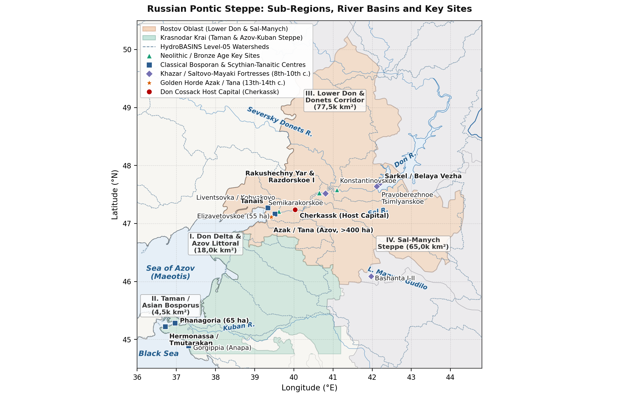
The Russian Pontic Steppe forms the land and river corridor between the North-Western Caucasus, the Sea of Azov (Maeotis), the Lower Don basin and the Caspian-Manych depression (Figure 1). Because rainfall and surface water vary sharply from the coast and floodplains to the dry eastern watersheds, settlement history across this 165,0k km² region is divided into four sub-regions:
- Lower Don Delta, Floodplain and Azov Littoral (18,0k km²): Encompassing Pochatkovsky (Porechny) Island (Rakushechny Yar), the Dead Donets (Mertvy Donets) and main Don delta branches (Elizavetovskoye, Tanais, the ten Maeotian-Tanaitic delta forts including Kobyakovo, Nizhne-Gnilovskoye and Podazovskoye, Golden Horde Azak/Tana, Cossack Cherkassk and Novocherkassk, and the modern port cities of Rostov-on-Don, Nakhichevan-on-Don, Taganrog, Azov and Yeysk) [15][25][26].
- Taman Peninsula / Asian Bosporus (4,5k km², including the 1,2k km² ancient Taman archipelago and Anapa/Gorgippia coast): Surveyed by Ya. M. Paromov [7], V. D. Kuznetsov [27], U. Schlotzhauer and D. V. Zhuravlev [28], G. P. Garbuzov and A. A. Zavoikin [8][9] and A. V. Batasova [29], this deltaic peninsula hosted the Greek cities of Phanagoria, Hermonassa (later Tamatarkha/Tmutarakan), Kepoi, Patraeus and Gorgippia (Anapa), and from 1792 the Black Sea (Kuban) Cossack settlements [30].
- Lower Don River Valley and Southern Don-Donets Corridor (77,5k km²): Comprising the main Lower Don valley and Tsimlyansk bend (
: Razdorskaya, Konstantinovsk, Semikarakorskoye, Sarkel / Belaya Vezha, Pravoberezhnoye Tsimlyanskoye and Cossack Razdory) and the northern tributary valleys of the Seversky Donets, Chir, Kalitva, lower Khopyor and lower Medveditsa ( ), which supported dense Late Bronze Age Srubnaya villages, Early Medieval Saltovo-Mayaki settlements, Don Cossack stanitsy and 19th-century coal-mining towns [6][12][22][31]. - Sal-Manych Watershed Steppe and Yergeni Slope (65,0k km²): The dry inland steppes and seasonal grazing corridors linking the Lower Don to the Caspian Depression along the Western and Eastern Manych, Sal, Yegorlyk and Kalaus rivers (Manych Catacomb burial grounds, Khazar-period Bashanta I-II, Don Kalmyk pastures and 19th-century Salsk and northern Stavropol peasant districts) [3][4][13].
Sources and Methods
Regional population estimates are compiled from five groups of archaeological and documentary evidence:
- Excavated Shell Middens and House Floors: For the Mesolithic and Neolithic periods (Rakushechny Yar, Razdorskaya 2, Kremennaya), excavated house floors (12-35 m² wattle-and-daub and Viviparus snail-shell platforms) and radiocarbon dates [1][2][32][33] indicate riverine densities of 0,016-0,065 persons/km².
- Kurgan Burial Grounds, Ancient Soils and Isotope Studies: For the Eneolithic, Early Bronze Age (Yamnaya) and Middle Bronze Age (Catacomb), N. I. Shishlina's [3] strontium, carbon and nitrogen isotope studies (
, , ) of seasonal grazing routes are combined with A. V. Borisov and R. A. Mimokhod's [4] buried-soil analyses across the Sal-Manych and Yergeni steppes. - Late Bronze Age Village and House Counts: For the Srubnaya (Timber-Grave) and Kobyakovo cultures (2000-900BC), counts of permanent river-terrace villages (poseleniya), excavated semi-subterranean timber-and-stone houses (5-20 dwellings of 80-250 m² per village) and household size estimates (8-12 persons per house) [5][6][34] are checked against skeletal mortality tables.
- Rural Field Surveys, Urban Excavations and Skeletal Life Tables: For the Classical, Hellenistic and Roman/Sarmatian periods (600BC - 370AD), Ya. M. Paromov's [7] survey of >230 rural settlements on the Taman Peninsula (1,2k km²), G. P. Garbuzov and A. A. Zavoikin's [8][9] agricultural land-use calculations, K. K. Marchenko, V. G. Zhitnikov and V. P. Kopylov's [26][35] estimates for Elizavetovskoye Gorodishche (44-55 ha, 3,0k-4,5k inhabitants) and M. A. Balabanova's [10] and E. F. Batieva's [11] skeletal mortality tables provide direct benchmarks.
- Medieval Urban Excavations, Russian Prikaz Rolls, Imperial Revisions and the 1897 Census: For the medieval and modern periods (740-1900AD), G. E. Afanasyev's [12] Saltovo-Mayaki settlement study and A. N. Maslovsky and I. B. Papka's [14][15] >250-trench urban density study of Golden Horde Azak (54,0k inhabitants in 1340AD) are combined with 17th-century Russian Posolsky and Razryadny Prikaz rolls [16][17], 18th- and 19th-century imperial tax revisions (1st-10th revizii, 1719-1858) [19][20][21][22] and the First All-Russian Imperial Census of 1897 [23][24][25].1
Prehistoric Fishing Communities and Bronze Age Herders (10000 - 900BC)
Final Palaeolithic, Mesolithic and Early Neolithic (10000 - 5000BC)
Studied by V. V. Tsybrij and A. V. Tsybrij [1], the Mesolithic sites of the Lower Don and Azov coast (Kremennaya II-III, Razdorskaya 2, Yuzhny Bugor, 10000-6200 cal BC) were flint-working camps and seasonal fishing stations on low floodplain terraces where inhabitants caught sturgeon (Acipenseridae), carp (Cyprinidae) and catfish (Silurus glanis) and hunted red deer and wild boar. Total population across the 165,0k km² region rose gradually from 2,6k in 10000BC (0,016 persons/km²) to 4,4k in 8000BC.
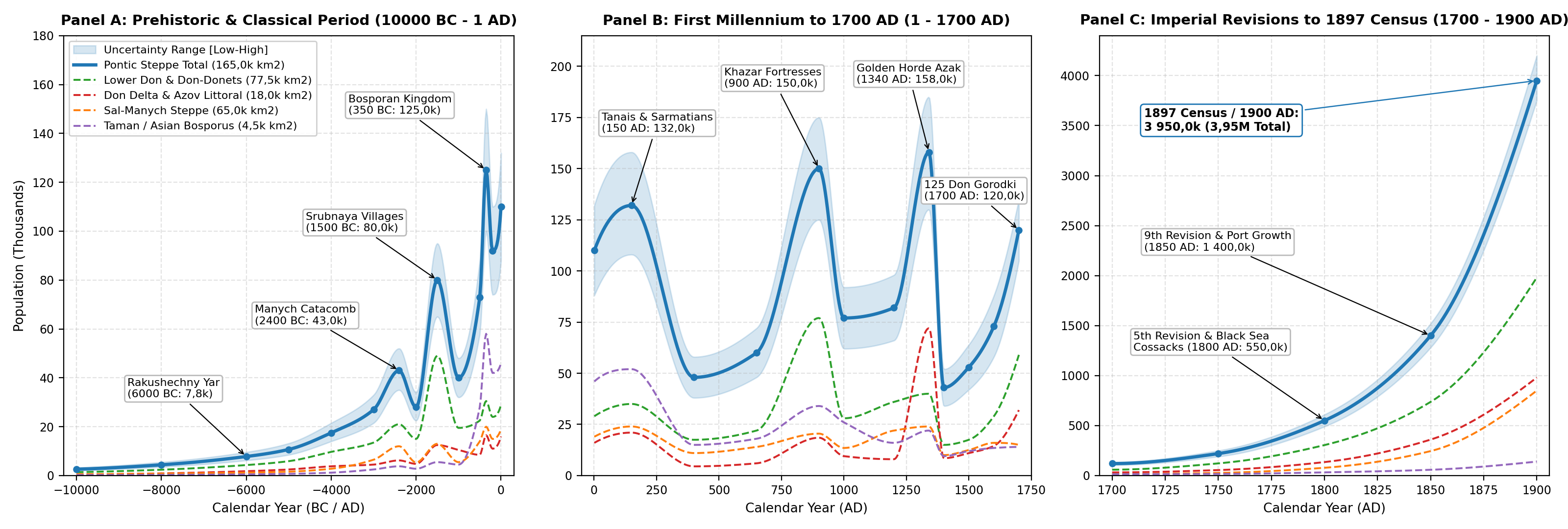
On Pochatkovsky (Porechny) Island near Stanitsa Razdorskaya in the Lower Don floodplain, the multi-layered settlement of Rakushechny Yar (excavated by T. D. Belanovskaya [36] and re-examined in 2008-2025 by E. V. Dolbunova, A. N. Mazurkevich, A. V. Tsybrij and V. V. Tsybrij [1][32][33]) contains 23 cultural layers reaching 5-6 m in depth. Radiocarbon and OSL dates place the earliest Neolithic shell-tempered pottery layers (Layers 23-15) between 6200/6000 and 5600 cal BC, making Rakushechny Yar one of the oldest pottery-producing villages in Europe [33]. Excavations uncovered artificial floors built from freshwater Viviparus snail shells (rakovinnye platformy), post-hole rows and clay-plastered wattle-and-daub (turluk) surfaces belonging to permanent riverine houses [32]. Individual floodplain villages housed 50-120 people (8-18 structures), raising Lower Don valley densities to 0,15-0,25 persons/km² and the regional population to 7,8k by 6000BC and 10,7k by 5000BC (Figure 2A).
Eneolithic and Early/Middle Bronze Age (5000 - 2000BC)
During the Eneolithic (5000-3300 cal BC), the Lower Don (Nizhnedonskaya), Sredny Stog / Novodanilovka and Konstantinovka traditions established river-terrace farming, herding and fishing villages (1,0-2,5 ha settlements with 60-150 residents each at Razdorskoye I and Samsonovskoye) alongside flat and low-mound cemeteries (Karatayevo, Mukhin). In an analysis of Layer 5 at Rakushechny Yar (a 55 cm-thick Viviparus shell midden dated to 4600-4300 cal BC), A. M. Skorobogatov, E. V. Dolbunova and A. N. Mazurkevich [2] showed that collared and comb-impressed Nizhnedonskaya pots make up 6,6% of the ceramic assemblage alongside local Late Neolithic vessels, consistent with a regional population of 17,5k by 4000BC.
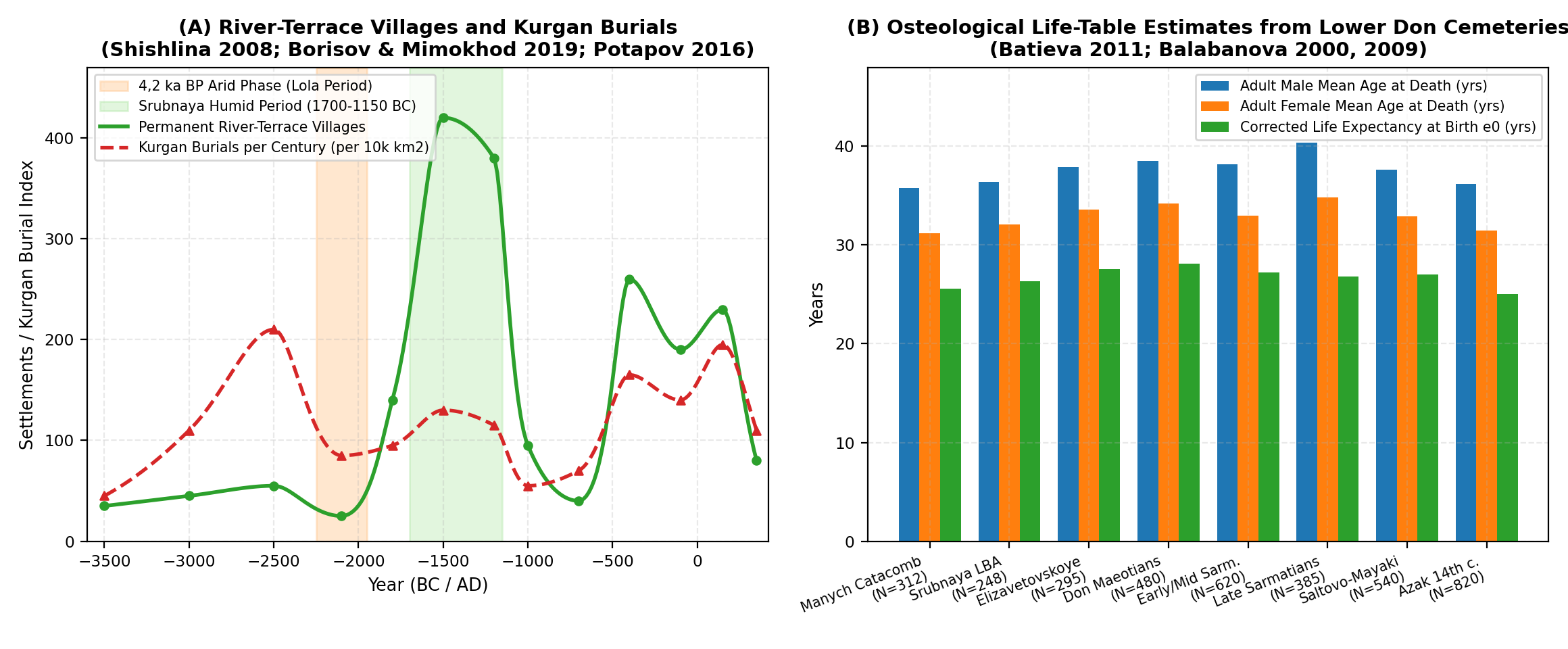
In her study Reconstruction of the Bronze Age of the Caspian Steppes [3], N. I. Shishlina showed that the transition to the Yamnaya (Pit-Grave, 3300-2600 cal BC) and Katakombnaya (Catacomb, 2600-2000 cal BC) periods introduced four-season mobile herding with heavy four-wheeled ox-wagons. Whereas Yamnaya herders moved along short river-valley loops (10-25 km), population growth during the Manych Catacomb phase (2500-2100 cal BC) led to longer north-south seasonal migrations (150-300 km routes linking the Lower Don and Manych lakes to the Stavropol Uplands and Yergeni Hills). Field surveys and buried-soil studies by A. V. Borisov and R. A. Mimokhod [4] record burial mound densities of 0,4-1,2 kurgans/km² along river terraces and 0,1-0,3 kurgans/km² on open watersheds, with 60-75% of all Bronze Age burials belonging to the Catacomb period. Heavy grazing contributed to alkaline soil (solonetz) formation before the 4,2 ka BP (2200-2000 cal BC) dry phase, which emptied the open Sal-Manych watersheds during the post-Catacomb Lola period [4]. Regional population rose from 27,0k in 3000BC to 43,0k during the Catacomb period (2400BC), before falling to 28,0k around 2000BC (Figure 3A).
Late Bronze Age Farming and Herding Villages (2000 - 900BC)
With wetter conditions returning after 1850/1750 cal BC, the Srubnaya (Timber-Grave) Culture (Berezhnovka-Mayovka group) produced a dense network of permanent farming and herding villages across the Lower Don, Seversky Donets, Chir, Khopyor and Azov coastal valleys. As summarised by E. S. Sharafutdinova [34] and V. V. Potapov [5][6], field surveys in Rostov Oblast and the southern Don basin have recorded more than 1,2k permanent Srubnaya settlements (poseleniya) along first and second river terraces and ravine springs, spaced 1,5-3,5 km apart.
Unlike temporary Yamnaya or Catacomb camps (stoyanki), Srubnaya villages (0,8-4,0 ha) consisted of 5 to 20 large semi-subterranean timber-framed and limestone-lined houses (poluzemlyanki), each measuring 80 to 250 m². Animal bone assemblages studied by V. V. Potapov [6] and V. R. Erlikh et al. [37] show settled herds dominated by cattle (50-65% cattle, alongside horses, sheep, goats and pigs). At 10-14 people per extended household, an average Srubnaya village of 8-12 occupied houses held 80-150 residents. Assuming that roughly 30% of the >1,2k recorded terrace settlements were occupied at the same time within any 100-year phase (350-450 contemporaneous villages), the Srubnaya population of the Russian Pontic Steppe reached 80,0k (65,0k-95,0k) around 1500BC (0,485 persons/km² overall; 1,5-2,8 persons/km² in the river valleys). During the Final Bronze Age (1200-900 cal BC), drier conditions reduced open-steppe village numbers and house sizes [5], while the stone-built Kobyakovo Culture [34] concentrated 15-25 fishing and bronze-working villages in the Don Delta (Kobyakovo, Safyanovo, Nizhne-Gnilovskoye), sustaining a regional population of 40,0k around 1000BC.
Greek Colonies, Tanais and Steppe Nomads (900BC - 370AD)
Cities and Rural Settlements of the Taman Peninsula and Gorgippia
On the Taman Peninsula (Asian Bosporus, an ancient archipelago of three main islands covering ~ 1,2k km²), Ya. M. Paromov [7] carried out a complete field and aerial survey that mapped >230 Greek and Sindian-Maeotian rural settlements (chora), fortified villages (such as Golubitskaya 2 at 7,2 ha, excavated by U. Schlotzhauer and D. V. Zhuravlev [28]), rectangular field systems and farmsteads (Figure 4A).
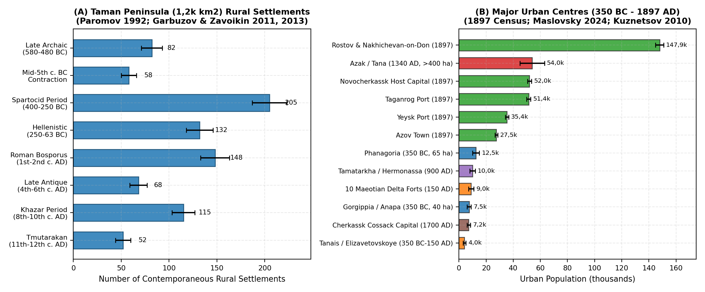
As reconstructed by G. P. Garbuzov, A. A. Zavoikin, A. A. Maslennikov and S. L. Smekalov [8][9] and A. V. Batasova [29], Greek settlement on Taman developed in two main stages:
- Late Archaic Settlement (580-480BC): Following the foundation of Hermonassa, Kepoi, Patraeus, Phanagoria (c. 542BC, founded by Teos) and inland settlements at Beregovoy 4, Golubitskaya 2 and Akhtanizovskaya 4, rural farmsteads spread across the peninsula, growing from 12-15 early sites to 70-93 contemporaneous rural settlements by 500-480BC [8][29].
- Classical and Early Hellenistic Spartocid Period (400-250BC): After Sindika was incorporated into the Bosporan Kingdom, 180-215 rural villages and estates were occupied at the same time on the Taman archipelago [7][9]. Phanagoria covered 65 ha (~ 43 ha on land plus 22 ha now submerged in Taman Bay), housing 10,0k-15,0k urban residents [27]. Together with Hermonassa (25-30 ha, 4,5k-6,5k), Kepoi (20-25 ha, 3,0k-4,5k), Patraeus (12-15 ha, 1,5k-2,5k), Gorgippia (modern Anapa, 40 ha, 6,0k-9,0k) and 20,0k-28,0k rural chora inhabitants, the Asian Bosporus supported 45,0k-65,0k people (58,0k midpoint in 350BC), corresponding to 37,5-54,2 persons/km² on Taman.
Lower Don Delta Trading Towns and Scythian-Sarmatian Nomads
In the Lower Don Delta, Elizavetovskoye Gorodishche (5th - early 3rd c. BC), excavated by K. K. Marchenko, V. G. Zhitnikov and V. P. Kopylov [26][35], covered 44-55 ha with a 12 ha inner citadel enclosed by two 4th-century BC ditch-and-rampart lines that housed a Bosporan Greek merchant quarter and later colony, supporting 3,0k-4,5k permanent inhabitants. Terracotta and pottery studies by N. I. Suvorova [38] show direct population continuity between the abandonment of Elizavetovskoye (c. 275-270BC) and the founding of Tanais (Nedvigovskoye Gorodishche) on the right bank of the Dead Donets (16-20 ha, 3,0k-5,0k residents). Between the 1st c. BC and 3rd c. AD, Bosporan rulers settled Kuban Maeotian farming and military communities in a ring of ten fortified delta towns (gorodishcha: Kobyakovo, Nizhne-Gnilovskoye, Podazovskoye, Krepkoye, Sukho-Chaltyrskoye, Temernitskoye, Khopry, Safyanovo, Lebyazhye and Rogozy), which held another 7,0k-11,0k settled inhabitants [39] until the Gothic-Borani raids of 244-254AD.
Across the surrounding Don-Manych-Azov steppes, E. F. Batieva [11] and M. A. Balabanova [10] examined >1,5k Scythian, Maeotian and Sarmatian skeletons, finding adult male mean ages at death (
Khazar Fortresses, Golden Horde Azak and the Early Don Cossacks (370 - 1700AD)
The Khazar Khaganate and the Saltovo-Mayaki Culture (740 - 965AD)
After population declined during the Hunnic and post-Hunnic centuries (48,0k in 400AD; 60,0k under Kubrat's Old Great Bulgaria in 650AD), the Khazar peace fostered widespread village and town settlement (the Saltovo-Mayaki Culture) along the Lower Don, the Tsimlyansk bend, the Manych valley and the Don-Donets borderlands [12][31][41]:
- Lower Don and Manych Fortresses: Anchored by the brick fortress of Sarkel (Levoberezhnoye Tsimlyanskoye, built c. 834-837AD; 3,7 ha citadel plus >15 ha outer town, 2,5k-4,0k inhabitants) [31], the white-stone fortress of Pravoberezhnoye Tsimlyanskoye (1,5k-2,5k) and the mudbrick fortress of Semikarakorskoye (3,8 ha citadel plus >30 ha settlement, 2,0k-3,5k) [41], surrounded by >120 open farming and wine-growing villages (selishcha). In the southern Sal-Manych / Western Kalmyk valley, M. A. Ochir-Goryaeva [13] excavated the twin Khazar-period fortified settlements of Bashanta I and Bashanta II, confirming permanent farming and herding villages along the Yergeni-Manych streams.
- Taman (Tamatarkha) and Don-Donets Valleys: On Taman, Ya. M. Paromov [7] mapped >110 Khazar-period (8th-10th c. AD) rural villages (with semi-dugouts and stone-foundation houses similar to Artezian [42]) around the port city of Tamatarkha (Hermonassa, ~ 35 ha, 8,0k-12,0k residents), supporting 34,0k inhabitants on the Asian Bosporus. Combined with G. E. Afanasyev's [12] Don-Donets Saltovo-Mayaki valley settlements (5,0-8,5 persons/km²), total regional population reached 150,0k (125,0k-175,0k) in 900AD, before Sviatoslav's 965AD campaign and Pecheneg-Cuman nomadism reduced the regional total to 77,0k-82,0k in 1000-1200AD.
Golden Horde Azak (Tana) and the Rise of the Don Cossack Host (1240 - 1700AD)
Founded around 1269-1270AD under Khan Mengu-Timur at the mouth of the Don (modern Azov), Azak (together with the Venetian and Genoese merchant quarters of Tana) served as the main western port of the Golden Horde. Drawing on rescue excavations across >250 trenches in modern Azov, A. N. Maslovsky [14][43] and A. N. Maslovsky and I. B. Papka [15] reconstructed the growth and contraction of the city (Figure 4B):
- Early Settlement (1290AD): Urban population of 3,0k-3,5k inhabitants.
- Peak Urban Expansion under Uzbek and Janibek (1340AD): Azak covered >400 ha with paved streets (3-8 m wide) and closely packed wattle-and-daub and mudbrick courtyard houses heated by underfloor kan flues and tandyr ovens, reaching an estimated 54,0k urban residents (35,0k-54,0k range) [15].
- Civil Wars (Velikaya Zamyatnya, 1359-1380AD) and Reign of Tokhtamysh (1381-1395AD): Political conflict and recurring plague epidemics reduced the inhabited area to a quarter of its former size and eliminated the outer artisan dugouts (zemlyanki) [14], leaving 12,5k-13,5k inhabitants on the eve of Timur's sack in September 1395AD [15].
Together with 18,0k rural delta farmers and 86,0k Kipchak-Tatar nomads in the Don-Manych-Azov steppes (part of a wider Azov-Kuban nomadic population estimated at up to 250,0k by Maslovsky and Papka [15]), the Russian Pontic Steppe reached 158,0k in 1340AD before dropping to 43,0k in 1400AD.
After the Ottoman conquest of Azak in 1475AD (leaving an Ottoman fortress town of 3,5k-6,0k residents) and the formation of the Lesser Nogai Horde (Kazyev Ulus, 25,0k-40,0k nomads), free Don Cossack communities (Voysko Donskoye) expanded from 4-6 early river-island strongholds (Razdory, Donskoy/Donetsky [18], and Cherkassk, founded in 1570) to 30-40 fortified towns (gorodki) by 1637 (22,0k-28,0k people) and 125 gorodki along the Don (56), Seversky Donets (11), Khopyor (23), Medveditsa (19) and Buzuluk (16) by 1695-1700AD [16]. As shown by S. Ya. Sushchiy [17], early family formation on the Lower Don (initially involving captive Turkish and Tatar women) was reinforced after 1650 by a steady influx of married Russian peasant families into the Upper Don towns. By 1700AD, following Peter I's 1696 capture and garrisoning of Azov and Taganrog, the Don Cossack Host numbered 65,0k-80,0k people, bringing the regional population to 120,0k (105,0k-135,0k).
Imperial Russian Colonisation, Industrialisation and the 1897 Census (1700 - 1900AD)
The Don Land in the 18th Century, Taganrog, Rostov and the Black Sea Cossacks (1700 - 1800AD)
During the early 18th century, the suppression of the Bulavin Rebellion (1707-1708) and the Temporary Transfer of Azov back to Ottoman rule (1711-1739) slowed growth along the lower river, but Russian and Ukrainian peasant migration onto the estates of Don Cossack elders (starshina) soon accelerated [19][21]. By 1750AD, follow-up military rolls and the Second Imperial Revision recorded ~220,0k inhabitants across the study region, including 55,0k in the Don Delta and Taganrog littoral (following the establishment of the Temernitskaya custom house in 1749), 122,0k across the Lower Don and Don-Donets stanitsy and peasant slobody, 27,0k Don Kalmyk and Nogai herders in the Sal-Manych steppe and 16,0k residents on the Taman Peninsula [19][20].
Following the Russo-Turkish War of 1768-1774 (Treaty of Küçük Kaynarca) and the annexation of the Azov-Kuban littoral (1783), imperial settlement transformed the coastal and southern steppes:
- Urban Foundations on the Lower Don and Taganrog Gulf: Taganrog was rebuilt as a naval and commercial port in 1769, the Fortress of St. Dimitry of Rostov (1761) grew into Rostov-on-Don, and in 1779 Catherine II resettled >12,0k Crimean Armenians on the adjacent right bank at Nakhichevan-on-Don and five surrounding villages (Chaltyr, Krym, Sultan-Saly, Nesvetay and Bolshiye Saly) [20][25].
- The Azov-Mozdok Line and Black Sea Cossack Resettlement (1777-1793): Between 1777 and 1783, the construction of the Azov-Mozdok fortified line encouraged state peasant settlement along the Yegorlyk and Manych valleys. In 1792-1793, the Black Sea Cossack Host (Chernomorskoye kazachye voysko, ~25,0k former Zaporozhian Cossacks) landed on Taman and settled 40 kureni across the Taman Peninsula and right-bank Kuban steppes [30][44].
- The Fifth Imperial Revision (1795 / 1800AD): As documented by A. P. Pronshtein [19] and V. M. Kabuzan [20], the registering of Ukrainian and Russian peasants attached to Don officer estates alongside the Cossack stanitsy raised the population of the Russian Pontic Steppe to 550,0k (490,0k-610,0k) by 1800AD (Figure 2B).
Peasant Colonisation, Railway Industrialisation and the 1897 Imperial Census (1800 - 1900AD)
In the first half of the 19th century, the transfer of the Don Host capital from flood-prone Starocherkassk to Novocherkassk (founded by Ataman M. I. Platov in 1805), the opening of the port of Yeysk on the Azov coast (1848) and the expansion of wheat exports through Taganrog and Rostov-on-Don drove rapid demographic growth. By the Ninth Revision of 1850, the study region contained 1 400,0k (1,40M) inhabitants, including 360,0k in the Don Delta and Azov port districts, 737,0k along the Lower Don and Don-Donets valleys, 245,0k in the Sal-Manych and northern Stavropol steppes and 58,0k on the Taman Peninsula [20][21].
After the Emancipation Reform of 1861, the end of the Caucasian War (1864) and the 1868 law permitting non-Cossack citizens (inogorodniye) to buy and lease property across the Don and Kuban territories, hundreds of thousands of land-short peasants from the Ukrainian and Central Russian Black-Earth governorates migrated into the region [22][30][45]. As M. A. Kolomeytseva [22] demonstrated, high rural birth rates (48-55 per 1 000) and peasant immigration coincided with the opening of the Grushevsky (Aleksandrovsk-Grushevsky / Shakhty) and Sulin anthracite coalfields, metallurgical plants at Taganrog and Sulin and the Voronezh-Rostov and Vladikavkaz railways.
The First All-Russian Imperial Census of 28 January 1897 [23][24] provides an exact baseline for the end of the 19th century:
- Province of the Don Cossack Host (Oblast Voyska Donskogo): Recorded 2 564,2k inhabitants across 164,5k km² (12,4% urban), of whom ~2 150,0k lived within the Lower Don, Don Delta/Taganrog, Donetsk, Sal-Manych and southern Ust-Medveditsa/Khopyor districts inside the study boundary (Rostov-on-Don 119,5k plus Nakhichevan-on-Don 28,4k = 147,9k combined agglomeration; Novocherkassk 52,0k; Taganrog 51,4k; Azov 27,5k; Aleksandrovsk-Grushevsky 16,5k) [23][25].
- Azov-Taman-Steppe Districts of Kuban Oblast and Northern Stavropol: Within the southern portion of the 165,0k km² study polygon, the Temryuksky (Taman), Yeysky (Yeysk city 35,4k) and northern Kavkazsky departments of Kuban Oblast [24][30] together with the Manych/Medvezhensky steppe districts of northern Stavropol Governorate accounted for a further 1 550,0k-1 650,0k residents in 1897.
Projecting forward at the observed 1,8% annual growth rate over the three years from January 1897 to 1900AD gives a regional population of 3 950,0k (3,95M; range 3 750,0k-4 200,0k, density 23,939 persons/km²) by 1900AD (Table 3).
| Settlement / Site | Sub-Region | Chronology | Core / Total Area (ha) | Population Estimate | Primary Literature |
|---|---|---|---|---|---|
| Rakushechny Yar | Lower Don (Pochatkovsky Isl.) | 6200-4300 cal BC | 1,2 (core) / 2,5 | 80-150 | Tsybrij et al. 2018; Skorobogatov 2025 |
| Kobyakovo (Final Bronze) | Lower Don Delta | 1200-900 cal BC | 3,5 (core) / 8,0 | 300-500 | Sharafutdinova 1980; Potapov 2013 |
| Phanagoria | Taman Peninsula | 542BC-10th c. AD | 43,0 (land) / 65,0 | 10,0k-15,0k (350BC) | Kuznetsov 2010; Garbuzov 2013 |
| Gorgippia (Anapa) | Asian Bosporus Coast | 5th c. BC-240AD | 35,0 / 40,0 | 6,0k-9,0k (350BC) | Paromov 1992; Garbuzov 2013 |
| Hermonassa / Tamatarkha | Taman Peninsula | 6th c. BC-14th c. AD | 25,0 / 35,0 | 4,5k-6,5k / 8,0k-12,0k | Garbuzov 2011; Batasova 2015 |
| Kepoi & Golubitskaya 2 | Taman Peninsula | 6th c. BC-4th c. AD | 20,0-25,0 / 7,2-9,0 | 3,0k-4,5k / 0,6k-1,0k | Schlotzhauer & Zhuravlev 2014 |
| Elizavetovskoye Gorodishche | Lower Don Delta | 500-270BC | 12,0 (cit.) / 44,0-55,0 | 3,0k-4,5k (4th c. BC) | Marchenko et al. 2000; Kopylov 2016 |
| Tanais (Nedvigovskoye) | Dead Donets (Don Delta) | 275BC-450AD | 14,0 / 20,0 | 3,0k-5,0k (150AD) | Suvorova 2025; Vdovchenkov 2019 |
| 10 Maeotian Delta Forts | Lower Don Delta | 1st c. BC-250AD | 0,5-4,0 / 10,0-35,0 ea. | 7,0k-11,0k (combined) | Vdovchenkov 2019 |
| Sarkel (Belaya Vezha) | Lower Don (Tsimlyansk) | 834-1117AD | 3,7 (fort) / 18,0 | 2,5k-4,0k (900AD) | Artamonov 1958; Afanasyev 1993 |
| Semikarakorskoye & Bashanta | Lower Don & Manych | 8th-10th c. AD | 3,8 (fort) / 32,0 | 2,0k-3,5k (900AD) | Flyorov 2011; Ochir-Goryaeva 2020 |
| Azak / Tana (Azov) | Lower Don Delta | 1270-1395AD | 120,0 / >400,0 | 54,0k (1340) / 13,0k (1395) | Maslovsky 2022; Maslovsky & Papka 2024 |
| Cherkassk (Starocherkassk) | Lower Don | 1570-1805AD | 35,0 / 60,0 | 6,0k-8,5k (1700) / 15,0k (1800) | Mininkov 1998; Pronshtein 1961 |
| Rostov & Nakhichevan-on-Don | Lower Don Delta | 1749/1779-1900AD | 680,0 / 1 250,0 | 147,9k (1897 Census) | Troynitsky 1905; Volvenko 2023 |
| Novocherkassk (Host Capital) | Lower Don Basin | 1805-1900AD | 320,0 / 550,0 | 52,0k (1897 Census) | Troynitsky 1905; Agafonov 2017 |
| Taganrog & Yeysk (Azov Ports) | Taganrog Gulf / Azov Coast | 1698/1848-1900AD | 410,0 / 720,0 | 51,4k & 35,4k (1897 Census) | Troynitsky 1905; Volvenko 2023 |
Limitations
Three practical constraints affect population estimates in the Russian Pontic Steppe:
- Sea-Level Change and Delta Siltation: Both the Taman Bay (where rising sea levels after the Classical period submerged ~ 22 ha of Phanagoria and coastal parts of Kepoi and Patraeus) [8][27] and the advancing Don Delta (where 5-7 m of river silt cover the prehistoric floodplain) conceal low-lying Mesolithic, Neolithic and Archaic shoreline camps.
- Burial Customs and Missing Children in Kurgan Cemeteries: As shown by M. A. Balabanova [10] and E. F. Batieva [11], Late Sarmatian (2nd-4th c. AD) burial mounds rarely include infants and young children (
) and contain more adult men than women (M/F > 2,0). Standard life-table corrections ( ) are therefore required instead of unadjusted skeletal averages. - Seasonal Movement and Pre-1897 Under-Registration: Nomadic groups (Manych Catacomb herders, Scythians, Sarmatians, Cumans, Golden Horde uluses, Lesser Nogais and Don Kalmyks) moved seasonally across the Sal-Manych, Kuban and Stavropol steppes [3][15], while early 18th-century Cossack and runaway peasant settlements frequently evaded imperial tax enumerators prior to the Fifth Revision of 1795 [19][21].
Conclusion
Archaeological, skeletal and archival records show that the Russian Pontic Steppe experienced four pre-modern phases of dense settlement before 1700AD: the Late Bronze Age Srubnaya river-terrace farming expansion (80,0k around 1500BC), the Classical and Roman Bosporan and Sarmatian period (125,0k-132,0k in 350BC - 150AD), the Khazar Saltovo-Mayaki fortress and village network (150,0k around 900AD) and the Golden Horde urban expansion centred on Azak/Tana (158,0k in 1340AD). Following Timur's destruction of Azak in 1395AD (43,0k in 1400AD) and the growth of the 125 Don Cossack towns to 120,0k by 1700AD, 18th- and 19th-century Russian, Ukrainian, Armenian and German colonisation of the black-earth steppes, Azov port trade and eastern Donbas coal mining raised the regional population more than thirtyfold to 550,0k in 1800AD, 1 400,0k in 1850AD and 3 950,0k (23,939 persons/km²) by 1900AD.
Appendix
Osteological Life-Table Estimates
| Archaeological Period | Sample (N) | Sub-Adult d(0-14) | Male AA (yrs) | Female AA (yrs) | Corrected e0 (yrs) | Sources |
|---|---|---|---|---|---|---|
| Manych Catacomb (MBA) | 312 | 34,6% | 35,8 | 31,2 | 24,5-26,8 | Batieva 2011 |
| Srubnaya (LBA, Lower Don) | 248 | 38,2% | 36,4 | 32,1 | 25,2-27,5 | Balabanova 2009; Batieva 2011 |
| Elizavetovskoye (4th c. BC) | 295 | 31,5% | 37,9 | 33,6 | 26,8-28,5 | Batieva 2011; Marchenko et al. 2000 |
| Lower Don Maeotians (1st-3rd c. AD) | 480 | 29,8% | 38,5 | 34,2 | 27,0-29,2 | Batieva 2011 |
| Early/Middle Sarmatians (3rd c. BC-2nd c. AD) | 620 | 24,5% (kurgan bias) | 38,2 | 33,0 | 26,0-28,4 | Balabanova 2009; Batieva 2011 |
| Late Sarmatians (mid-2nd-4th c. AD) | 385 | 6,8% (burial filter) | 40,4 | 34,8 | 25,5-28,0 | Balabanova 2009; Batieva 2011 |
| Saltovo-Mayaki (Sarkel & Lower Don) | 540 | 35,4% | 37,6 | 32,9 | 25,8-28,2 | Afanasyev 1993; Batieva 2011 |
| Golden Horde Azak (14th c. AD) | 820 | 41,0% (plague/sack) | 36,2 | 31,5 | 23,5-26,5 | Batieva 2011; Maslovsky 2024 |
Population Estimates
| Year | Don Delta (18,0k km²) | Taman (4,5k km²) | Lower Don (37,5k km²) | Sal-Manych (65,0k km²) | Don-Donets (40,0k km²) | Total Population [Range] | Density (p/km²) |
|---|---|---|---|---|---|---|---|
| 10000BC | 0,5k | 0,2k | 0,8k | 0,5k | 0,6k | 2,6k [2,0k-3,3k] | 0,016 |
| 8000BC | 0,9k | 0,3k | 1,4k | 0,8k | 1,0k | 4,4k [3,5k-5,5k] | 0,027 |
| 6000BC | 1,8k | 0,5k | 2,6k | 1,2k | 1,7k | 7,8k [6,2k-9,6k] | 0,047 |
| 5000BC | 2,5k | 0,7k | 3,5k | 1,6k | 2,4k | 10,7k [8,5k-13,2k] | 0,065 |
| 4000BC | 3,8k | 1,2k | 5,5k | 2,8k | 4,2k | 17,5k [14,0k-21,5k] | 0,106 |
| 3000BC | 4,5k | 2,5k | 7,5k | 6,5k | 6,0k | 27,0k [21,5k-33,0k] | 0,164 |
| 2400BC | 6,2k | 3,8k | 11,5k | 12,0k | 9,5k | 43,0k [35,0k-52,0k] | 0,261 |
| 2000BC | 4,8k | 2,8k | 8,0k | 5,4k | 7,0k | 28,0k [22,5k-34,0k] | 0,170 |
| 1500BC | 12,5k | 5,5k | 24,0k | 13,0k | 25,0k | 80,0k [65,0k-95,0k] | 0,485 |
| 1000BC | 10,5k | 4,5k | 11,0k | 5,5k | 8,5k | 40,0k [32,0k-48,0k] | 0,242 |
| 500BC | 8,5k | 28,0k | 12,0k | 14,0k | 10,5k | 73,0k [58,0k-88,0k] | 0,442 |
| 350BC | 16,5k | 58,0k | 16,0k | 20,0k | 14,5k | 125,0k [100,0k-150,0k] | 0,758 |
| 200BC | 11,0k | 42,0k | 12,5k | 15,0k | 11,5k | 92,0k [74,0k-110,0k] | 0,558 |
| 1AD | 16,0k | 46,0k | 15,5k | 19,0k | 13,5k | 110,0k [88,0k-132,0k] | 0,667 |
| 150AD | 21,0k | 52,0k | 19,0k | 24,0k | 16,0k | 132,0k [108,0k-158,0k] | 0,800 |
| 400AD | 4,5k | 15,0k | 9,5k | 11,0k | 8,0k | 48,0k [38,0k-58,0k] | 0,291 |
| 650AD | 6,0k | 18,0k | 12,0k | 14,0k | 10,0k | 60,0k [48,0k-72,0k] | 0,364 |
| 900AD | 18,5k | 34,0k | 42,0k | 20,5k | 35,0k | 150,0k [125,0k-175,0k] | 0,909 |
| 1000AD | 9,5k | 26,0k | 16,0k | 13,5k | 12,0k | 77,0k [62,0k-92,0k] | 0,467 |
| 1200AD | 8,0k | 16,0k | 18,0k | 22,0k | 18,0k | 82,0k [66,0k-98,0k] | 0,497 |
| 1340AD | 72,0k | 22,0k | 24,0k | 24,0k | 16,0k | 158,0k [130,0k-185,0k] | 0,958 |
| 1400AD | 8,5k | 9,5k | 8,0k | 10,0k | 7,0k | 43,0k [34,0k-52,0k] | 0,261 |
| 1500AD | 11,0k | 12,0k | 9,5k | 12,5k | 8,0k | 53,0k [42,0k-64,0k] | 0,321 |
| 1600AD | 14,5k | 13,5k | 15,0k | 16,0k | 14,0k | 73,0k [58,0k-88,0k] | 0,442 |
| 1700AD | 32,0k | 14,0k | 28,0k | 15,0k | 31,0k | 120,0k [105,0k-135,0k] | 0,727 |
| 1750AD | 55,0k | 16,0k | 52,0k | 27,0k | 70,0k | 220,0k [190,0k-250,0k] | 1,333 |
| 1800AD | 135,0k | 32,0k | 115,0k | 78,0k | 190,0k | 550,0k [490,0k-610,0k] | 3,333 |
| 1850AD | 360,0k | 58,0k | 275,0k | 245,0k | 462,0k | 1 400,0k [1 280,0k-1 520,0k] | 8,485 |
| 1900AD | 980,0k | 140,0k | 780,0k | 850,0k | 1 200,0k | 3 950,0k [3 750,0k-4 200,0k] | 23,939 |
Sources
1.Tsybrij, Andrey Vitalyevich, et al. "Novyye issledovaniya ranneneoliticheskikh sloyev poseleniya Rakushechnyy Yar [New Investigations of the Early Neolithic Layers of the Rakushechny Yar Settlement]." Samarskiy nauchnyy vestnik, vol. 7, no. 3 (24), 2018, pp. 215-224, https://cyberleninka.ru/article/n/novye-issledovaniya-ranneneoliticheskih-sloev-poseleniya-rakushechnyy-yar, Archived PDF (tsybriy_andrey_vitalevich_2018_novye_issledovaniya_ranneneoliticheskih_sloe.pdf).
2.Skorobogatov, Andrey Mikhaylovich, et al. "Keramicheskiy kompleks nizhnedonskoy kul'tury pamyatnika Rakushechnyy Yar (sloy 5) [Ceramic Complex of the Lower Don Culture of the Rakushechny Yar Site (Layer 5)]." Camera praehistorica, no. 1 (14), 2025, pp. 26-39, https://doi.org/10.31250/2658-3828-2025-1-26-39, Archived PDF (a_m_skorobogatov_2025_keramicheskiy_kompleks_nizhnedonskoy_kultury_pamyatni.pdf).
3.Shishlina, Natalya Ivanovna. Reconstruction of the Bronze Age of the Caspian Steppes: Life Styles and Life Ways of Pastoral Nomads. Archaeopress, 2008, pp. 1-399, https://doi.org/10.30861/9781407303567.
4.Borisov, Aleksandr Vladimirovich, and Roman Alekseyevich Mimokhod. "Palaeosols and Natural Conditions of the South Russian Steppes in the Bronze Age." Arid Ecosystems, vol. 9, no. 1, 2019, pp. 12-21, https://doi.org/10.1134/S2079096119010037, Archived PDF (borisov_mimokhod_2019_steppe_bronze_age_palaeosols.pdf).
5.Potapov, Vadim Valeryevich. "Pogrebeniye epokhi final'noy bronzy iz mogil'nika ``Krest'' v del'te Dona [Final Bronze Age Burial from the ``Krest'' Cemetery in the Don Delta]." Arkheologicheskiye zapiski, vol. 8, 2013, pp. 213-229, https://cyberleninka.ru/article/n/pogrebenie-epohi-finalnoy-bronzy-iz-mogilnika-krest-v-delte-dona, Archived PDF (potapov_vadim_valerevich_2013_pogrebenie_epohi_finalnoy_bronzy_iz_mogilnika.pdf).
6.Potapov, Vadim Valeryevich. "Khozyaystvennyye uklady naseleniya dono-donetskogo regiona i vostochnogo Priazov'ya perioda pozdney i final'noy bronzy: dinamika ikh razvitiya [Economic Structures of the Population of the Don-Donets Region and Eastern Azov Region in the Late and Final Bronze Age]." Sciences of Europe, no. 7 (7), 2016, pp. 58-67, https://cyberleninka.ru/article/n/hozyaystvennye-uklady-naseleniya-donodonetskogo-regiona-i-vostochnogo-priazovya-perioda-pozdney-i-finalnoy-bronzy-dinamika-ih-razvitiya, Archived PDF (potapov_v_v_2016_hozyaystvennye_uklady_naseleniya_donodonetskogo_regiona_i.pdf).
7.Paromov, Yakov Maksimovich. Arkheologicheskaya karta Tamanskogo poluostrova [Archaeological Map of the Taman Peninsula]. INION RAN, 1992, pp. 1-469, https://cyberleninka.ru/article/n/glavnye-dorogi-tamanskogo-poluostrova-v-antichnoe-vremya.
8.Garbuzov, Gennadiy Pavlovich, and Aleksey Andreyevich Zavoikin. "Osvoyeniye grekami zemel' Tamanskogo poluostrova v posledney chetverti VI - pervoy polovine V v. do n.e. [Greek Colonisation of the Lands of the Taman Peninsula in the Last Quarter of the 6th - First Half of the 5th Century BC]." Antichnyy mir i arkheologiya, vol. 15, 2011, pp. 194-223, https://cyberleninka.ru/article/n/osvoenie-grekami-zemel-tamanskogo-poluostrova-v-posledney-chetverti-vi-pervoy-polovine-v-v-do-n-e, Archived PDF (garbuzov_gennadiy_pavlovich_2011_osvoenie_grekami_zemel_tamanskogo_poluostr.pdf).
9.Garbuzov, Gennadiy Pavlovich, et al. "Sel'skaya territoriya Yevropeyskogo i Aziatskogo Bospora v epokhu Spartokidov (opyt sravnitel'nogo analiza) [The Rural Territory of the European and Asian Bosporus in the Spartocid Epoch (A Comparative Analysis)]." Problemy istorii, filologii, kul'tury, no. 4 (42), 2013, pp. 49-66, https://cyberleninka.ru/article/n/selskaya-territoriya-evropeyskogo-i-aziatskogo-bospora-v-epohu-spartokidov-opyt-sravnitelnogo-analiza, Archived PDF (garbuzov_gennadiy_pavlovich_2013_selskaya_territoriya_evropeyskogo_i_aziats.pdf).
10.Balabanova, Mariya Afanasyevna. "Khronologicheskiye osobennosti polovozrastnoy struktury savromato-sarmatskogo naseleniya Nizhnego Povolzh'ya i Yuzhnogo Priural'ya [Chronological Features of the Age-Sex Structure of the Sauromatian-Sarmatian Population of the Lower Volga and Southern Urals]." Vestnik Volgogradskogo gosudarstvennogo universiteta. Seriya 4, Istoriya, no. 1 (15), 2009, pp. 5-12, https://cyberleninka.ru/article/n/hronologicheskie-osobennosti-polovozrastnoy-struktury-savromato-sarmatskogo-naseleniya-nizhnego-povolzhya-i-yuzhnogo-priuralya, Archived PDF (balabanova_mariya_afanasevna_2009_hronologicheskie_osobennosti_polovozrastn.pdf).
11.Batieva, Yelena Fedorovna. Naseleniye Nizhnego Dona v IX v. do n.e. - IV v. n.e. (paleoantropologicheskoye issledovaniye) [The Population of the Lower Don in the 9th Century BC - 4th Century AD (A Palaeoanthropological Study)]. Southern Scientific Centre of the Russian Academy of Sciences (SSC RAS), 2011, pp. 1-160, https://www.ssc-ras.ru/files/files/Batieva_2011.pdf.
12.Afanasyev, Gennadiy Yevgenyevich. Donskiye alany: Sotsial'nyye struktury alano-asso-burtasskogo naseleniya basseyna Srednego Dona [The Don Alans: Social Structures of the Alan-As-Burtas Population of the Middle Don Basin]. Nauka, 1993, pp. 1-184, https://cyberleninka.ru/article/n/sistema-rasseleniya-lesostepnogo-varianta-saltovo-mayatskoy-kultury.
13.Ochir-Goryaeva, Mariya Aleksandrovna. "Gorodishcha Bashanta-I i Bashanta-II epokhi Khazarskogo kaganata [Fortified Settlements of Bashanta-I and Bashanta-II of the Khazar Khaganate Epoch]." Oriental Studies, vol. 13, no. 4, 2020, pp. 830-842, https://doi.org/10.22162/2619-0990-2020-50-4-830-842, Archived PDF (ochir_goryaeva_mariya_aleksandrovna_2020_gorodischa_bashanta_i_i_bashanta_i.pdf).
14.Maslovsky, Andrey Nikolayevich. "Zolotoordynskiy Azak vo vremya pravleniya khana Tokhtamysha (1381-1395 gg.) [Golden Horde Azak during the Reign of Khan Tokhtamysh (1381-1395)]." Arkheologiya Yevraziyskikh Stepey, no. 4, 2022, pp. 185-197, https://doi.org/10.24852/2587-6112.2022.4.185.197, Archived PDF (maslovskiy_andrey_nikolaevich_2022_zolotoordynskiy_azak_vo_vremya_pravleniy.pdf).
15.Maslovsky, Andrey Nikolayevich, and Irina Borisovna Papka. "O chislennosti naseleniya zolotoordynskogo Azaka i yego okrugi [On the Population Size of Golden Horde Azak and its Periphery]." Arkheologiya Yevraziyskikh Stepey, no. 2, 2024, pp. 241-252, https://doi.org/10.24852/2587-6112.2024.2.241.252, Archived PDF (andrey_nikolaevich_maslovskiy_2024_o_chislennosti_naseleniya_zolotoordynsko.pdf).
16.Mininkov, Nikolay Aleksandrovich. Donskoye kazachestvo v epokhu pozdnego srednevekov'ya (do 1671 g.) [The Don Cossacks in the Late Middle Ages (up to 1671)]. Rostov State University Press, 1998, pp. 1-512.
17.Sushchiy, Sergey Yakovlevich. "Institut sem'i u donskikh kazakov i sposob demograficheskogo vosproizvodstva kazach'yego sotsiuma (konets XVI - nachalo XVIII v.) [The Institution of the Family among the Don Cossacks and the Mode of Demographic Reproduction of Cossack Society]." Novoye proshloye / The New Past, no. 4, 2019, pp. 112-131, https://doi.org/10.23683/2500-3224-2019-4-112-131, Archived PDF (sushchiy_sergey_yakovlevich_2019_institut_semi_u_donskih_kazakov_i_sposob_d.pdf).
18.Prudnikov, Yaroslav Vladimirovich. "Donskoy / Donetskiy kazachiy gorodok: odno ili dva poseleniya? [Donskoy / Donetsk Cossack Town: One or Two Settlements?]." Vestnik Volgogradskogo gosudarstvennogo universiteta. Seriya 4, Istoriya, vol. 29, no. 2, 2024, pp. 46-54, https://doi.org/10.15688/jvolsu4.2024.2.4, Archived PDF (yaroslav_vladimirovich_prudnikov_2024_donskoy_donetskiy_kazachiy_gorodok_od.pdf).
19.Pronshtein, Aleksandr Pavlovich. Zemlya Donskaya v XVIII veke [The Don Land in the 18th Century]. Rostov University Press, 1961, pp. 1-376.
20.Kabuzan, Vladimir Maksimovich. Zaseleniye Novorossii (Yekaterinoslavskoy i Khersonskoy guberniy) v XVIII - pervoy polovine XIX veka (1719-1858 gg.) [Settlement of New Russia in the 18th - First Half of the 19th Century (1719-1858)]. Nauka, 1976, pp. 1-306.
21.Agafonov, Anatoliy Ivanovich. "Ot zemli Donskogo voyska k Oblasti voyska Donskogo (seredina XIX - nachalo XX veka) [From the Land of the Don Host to the Province of the Don Cossack Host (Mid-19th - Early 20th Century)]." Izvestiya vysshikh uchebnykh zavedeniy. Severo-Kavkazskiy region. Obshchestvennyye nauki, no. 3 (195), 2017, pp. 38-45, https://cyberleninka.ru/article/n/ot-zemli-donskogo-voyska-k-oblasti-voyska-donskogo-seredina-xix-nachalo-hh-veka, Archived PDF (agafonov_anatoliy_ivanovich_2017_ot_zemli_donskogo_voyska_k_oblasti_voyska_.pdf).
22.Kolomeytseva, Mariya Andreyevna. "Demograficheskiye protsessy v srede krest'yanstva Dona v kontse XIX v. [Demographic Processes among the Peasantry of the Don at the End of the 19th Century]." Oriental Studies, no. 4 (38), 2018, pp. 53-62, https://doi.org/10.22162/2619-0990-2018-38-4-53-62, Archived PDF (kolomeytseva_mariya_andreevna_2018_demograficheskie_protsessy_v_srede_krest.pdf).
23.Troynitsky, Nikolay Aleksandrovich. Pervaya vseobshchaya perepis' naseleniya Rossiyskoy imperii, 1897 g. Tom XII: Oblast' Voyska Donskogo [First General Census of the Population of the Russian Empire, 1897. Vol. XII: Province of the Don Cossack Host]. Tsentral'nyy statisticheskiy komitet MVD, 1905, pp. 1-255.
24.Troynitsky, Nikolay Aleksandrovich. Pervaya vseobshchaya perepis' naseleniya Rossiyskoy imperii, 1897 g. Tom LXV: Kubanskaya oblast' [First General Census of the Population of the Russian Empire, 1897. Vol. LXV: Kuban Province]. Tsentral'nyy statisticheskiy komitet MVD, 1905, pp. 1-263.
25.Volvenko, Aleksey Aleksandrovich, and K. S. Panin. "Ob etnolingvisticheskom sostave naseleniya Severnogo Priazov'ya po perepisi 1897 goda i materialam etnograficheskoy kartografii XIX stoletiya [On the Ethnolinguistic Composition of the Population of the Northern Azov Region According to the 1897 Census]." Vestnik Taganrogskogo instituta imeni A. P. Chekhova, no. 1, 2023, pp. 132-141, https://cyberleninka.ru/article/n/ob-etnolingvisticheskom-sostave-naseleniya-severnogo-priazovya-po-perepisi-1897-goda-i-materialam-etnograficheskoy-kartografii-xix, Archived PDF (volvenko_aleksey_aleksandrovich_2023_ob_etnolingvisticheskom_sostave_nasele.pdf).
26.Marchenko, Konstantin Konstantinovich, et al. Yelizavetovskoye gorodishche na Donu [The Elizavetovskoye Fortified Settlement on the Don]. Paleograf / DAI Eurasia Department, 2000, pp. 1-282.
27.Kuznetsov, Vladimir Dmitriyevich. "Phanagoria and its Metropolis." Antiquities of Bosporus, vol. 15, 2010, pp. 208-228, https://www.researchgate.net/publication/318456923.
28.Schlotzhauer, Udo, and Denis Valeryevich Zhuravlev. "Greek Colonization in the Cimmerian Bosporus: New Results of the Russian-German Archaeological Project on the Taman Peninsula." Eurasia Antiqua, vol. 20, 2014, pp. 185-224, https://www.researchgate.net/publication/282154980.
29.Batasova, Anzhela Vladimirovna. "Osvoyeniye Tamanskogo poluostrova v VI - nachale V v. do n.e. [Colonisation of the Taman Peninsula in the 6th - Early 5th Century BC]." Problemy istorii, filologii, kul'tury, no. 1 (47), 2015, pp. 140-152, https://cyberleninka.ru/article/n/osvoenie-tamanskogo-poluostrova-v-vi-nachale-v-v-do-n-e, Archived PDF (batasova_anzhela_vladimirovna_2015_osvoenie_tamanskogo_poluostrova_v_vi_nac.pdf).
30.Burykina, Lyudmila Vasilyevna. "Osvoyeniye russkimi i ukrainskimi poselentsami Severo-Zapadnogo Kavkaza (konets XIX - nachalo XX vv.) [Settlement of the North-Western Caucasus by Russian and Ukrainian Colonists (Late 19th - Early 20th Centuries)]." Vestnik Adygeyskogo gosudarstvennogo universiteta. Seriya 1: Regionovedeniye, no. 8, 2008, pp. 45-52, https://cyberleninka.ru/article/n/osvoenie-russkimi-i-ukrainskimi-poselentsami-severo-zapadnogo-kavkaza-konets-hih-nachalo-hh-vv, Archived PDF (burykina_lyudmila_vasilevna_2008_osvoenie_russkimi_i_ukrainskimi_poselentsa.pdf).
31.Artamonov, Mikhail Illarionovich. "Sarkel - Belaya Vezha." Materialy i issledovaniya po arkheologii SSSR (MIA), vol. 62, 1958, pp. 7-84, http://kronk.spb.ru/library/artamonov-mi-1958.htm.
32.Dolbunova, Yekaterina Vladimirovna, et al. "Rakovinnyye platformy i zhilyye konstruktsii: planigrafiya kul'turnogo sloya rannego neolita p. Rakushechnyy Yar [Shell Platforms and Dwelling Structures: Planigraphy of the Early Neolithic Cultural Layer of the Rakushechny Yar Settlement]." Universum Humanitarium, no. 2, 2021, pp. 58-84, https://doi.org/10.25205/2499-9997-2021-2-58-84.
33.Dolbunova, Yekaterina Vladimirovna, et al. "Novyye dannyye po khronologii i stratigrafii pamyatnika Rakushechnyy Yar [New Data on the Chronology and Stratigraphy of the Rakushechny Yar Site]." Izvestiya Irkutskogo gosudarstvennogo universiteta. Seriya Geoarkheologiya. Etnologiya. Antropologiya, vol. 42, 2022, pp. 106-121, https://doi.org/10.26516/2227-2380.2022.42.106.
34.Sharafutdinova, Эlza Safronovna. Pamyatniki predskifskogo vremeni na Nizhnem Donu (Kobyakovskaya kul'tura) [Monuments of the Pre-Scythian Period on the Lower Don (The Kobyakovo Culture)]. Nauka, 1980, pp. 1-128.
35.Kopylov, Viktor Pavlovich. "O vremeni sooruzheniya oboronitel'nykh rubezhey na Yelizavetovskom gorodishche [On the Time of Construction of Defensive Lines at the Elizavetovskoye Fortified Settlement]." Bosporskiye issledovaniya, vol. 33, 2016, pp. 116-124, https://cyberleninka.ru/article/n/o-vremeni-sooruzheniya-oboronitelnyh-rubezhey-na-elizavetovskom-gorodische, Archived PDF (kopylov_viktor_pavlovich_2016_o_vremeni_sooruzheniya_oboronitelnyh_rubezhey.pdf).
36.Belanovskaya, Tatyana Dmitriyevna. Iz drevneyshego proshlogo Nizhnego Podon'ya: Poseleniye vremeni neolita i eneolita Rakushechnyy Yar [From the Most Ancient Past of the Lower Don: The Neolithic and Eneolithic Settlement of Rakushechny Yar]. Saint Petersburg State University Press, 1995, pp. 1-199.
37.Erlikh, Vladimir Roaldovich, et al. "Sostav stada i myasnaya diyeta postdol'mennogo gorizonta poseleniya kontsa epokhi bronzy - nachala rannego zheleznogo veka [Herd Composition and Meat Diet of the Final Bronze - Early Iron Age Settlement Horizon]." Istoriya, arkheologiya i etnografiya Kavkaza, vol. 15, no. 1, 2019, pp. 47-56, https://doi.org/10.32653/CH15147-56, Archived PDF (erlikh_vladimir_roaldovich_2019_sostav_stada_i_myasnaya_dieta_postdolmennog.pdf).
38.Suvorova, Nadezhda Igorevna. "K voprosu o preyemstvennosti kul'tur Yelizavetovskogo i Nedvigovskogo gorodishch (na primere analiza predmetov koroplastiki) [On the Question of Cultural Continuity between the Elizavetovskoye and Nedvigovskoye Settlements]." Bosporskiye issledovaniya, vol. 50, 2025, pp. 93-106, https://cyberleninka.ru/article/n/k-voprosu-o-preemstvennosti-kultur-elizavetovskogo-i-nedvigovskogo-gorodisch-na-primere-analiza-predmetov-koroplastiki, Archived PDF (suvorova_nadezhda_igorevna_2025_k_voprosu_o_preemstvennosti_kultur_elizavet.pdf).
39.Vdovchenkov, Yevgeniy Viktorovich. "Sotsial'no-politicheskaya organizatsiya donskikh meotov v sarmatskuyu epokhu [Socio-Political Organisation of the Don Maeotians in the Sarmatian Epoch]." Nizhnevolzhskiy Arkheologicheskiy Vestnik, vol. 18, no. 2, 2019, pp. 55-71, https://doi.org/10.15688/nav.jvolsu.2019.2.4.
40.Skripkin, Anatoliy Stepanovich. "K probleme opredeleniya chislennosti sarmatskogo naseleniya v Nizhnem Povolzh'ye [On the Problem of Determining the Size of the Sarmatian Population in the Lower Volga Region]." Vestnik Volgogradskogo gosudarstvennogo universiteta. Seriya 4, Istoriya, no. 1 (21), 2012, pp. 20-23, https://cyberleninka.ru/article/n/k-probleme-opredeleniya-chislennosti-sarmatskogo-naseleniya-v-nizhnem-povolzhie, Archived PDF (skripkin_anatoliy_stepanovich_2012_k_probleme_opredeleniya_chislennosti_sar.pdf).
41.Flyorov, Valeriy Sergeyevich. ``Goroda'' i ``zamki'' Khazarskogo kaganata. Arkheologicheskaya real'nost' [``Cities'' and ``Castles'' of the Khazar Khaganate: Archaeological Reality]. Mosty kul'tury / Gesharim, 2011, pp. 1-264, https://cyberleninka.ru/article/n/kreposti-hazarskogo-kaganata-na-nizhnem-donu.
42.Vinokurov, Nikolay Igorevich, and Leonid Yuryevich Ponomarev. "Tsentral'nyy uchastok saltovo-mayatskogo poseleniya na gorodishche Artezian (po itogam issledovaniy na raskope I v 1989-2001 gg.) [The Central Sector of the Saltovo-Mayaki Settlement at the Artezian Fortified Site]." Problemy istorii, filologii, kul'tury, no. 1 (51), 2016, pp. 186-232, https://cyberleninka.ru/article/n/tsentralnyy-uchastok-saltovo-mayatskogo-poseleniya-na-gorodische-artezian-po-itogam-issledovaniy-na-raskope-i-v-1989-2001-gg, Archived PDF (vinokurov_nikolay_igorevich_2016_tsentralnyy_uchastok_saltovo_mayatskogo_po.pdf).
43.Maslovsky, Andrey Nikolayevich. "Zolotoordynskiy Azak vo vtoroy polovine XIV v.: krusheniye i vozrozhdeniye [Golden Horde Azak in the Second Half of the 14th Century: Collapse and Revival]." Stratum plus, no. 6, 2017, pp. 215-234, https://cyberleninka.ru/article/n/zolotoordynskiy-azak-vo-vtoroy-polovine-xiv-v-krushenie-i-vozrozhdenie.
44.Parshina, Natalya Viktorovna. "K voprosu o provedenii sudebnoy reformy na territorii Kubanskogo kazach'yego voyska vo vtoroy polovine XIX veka [On the Implementation of Judicial Reform in the Territory of the Kuban Cossack Host in the Second Half of the 19th Century]." Istoriko-pravovyye problemy: novyy rakurs, no. 1, 2023, pp. 92-101, https://cyberleninka.ru/article/n/k-voprosu-o-provedenii-sudebnoy-reformy-na-territorii-kubanskogo-kazachiego-voyska-vo-vtoroy-polovine-xix-veka, Archived PDF (parshina_natalya_viktorovna_2023_k_voprosu_o_provedenii_sudebnoy_reformy_na.pdf).
45.Shadrina, Alla Valeryevna. "Edinovercheskoye naseleniye Oblasti voyska Donskogo v nachale XX veka: chislennost' i lokalizatsiya [The Edinoverie Population of the Province of the Don Cossack Host in the Early 20th Century: Size and Localisation]." Izvestiya vysshikh uchebnykh zavedeniy. Severo-Kavkazskiy region. Obshchestvennyye nauki, no. 2 (206), 2020, pp. 85-92, https://cyberleninka.ru/article/n/edinovercheskoe-naselenie-oblasti-voyska-donskogo-v-nachale-xx-veka-chislennost-i-lokalizatsiya, Archived PDF (shadrina_alla_valerevna_2020_edinovercheskoe_naselenie_oblasti_voyska_donsk.pdf).
1 All archived full-text academic PDFs cited in this review are stored locally in ./papers/.
PDFCompiled Manuscript (1,71 MB)