DEMOGRAPHIC AND SETTLEMENT HISTORY OF CIRCASSIA AND CENTRAL CISCAUCASIA.
A Regional Literature Review of Population and Settlement (10000BC - 1900AD).
Abstract
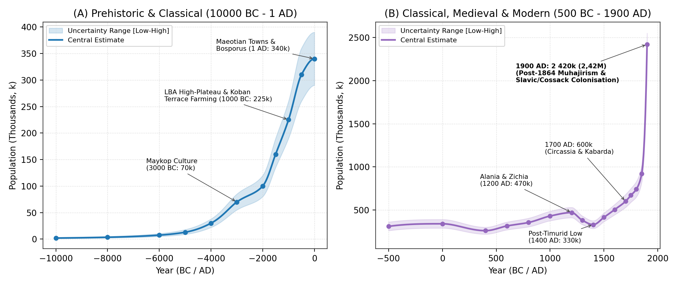
This paper reviews the archaeological, geoarchaeological, bioarchaeological, classical-epigraphic, and archival literature to reconstruct the population and settlement history of Historical Circassia and Central Ciscaucasia (122,9k km² across Krasnodar Krai, Adygea, Karachay-Cherkessia, Kabardino-Balkaria, North Ossetia-Alania, and the Pyatigorye / Kislovodsk basin of southern Stavropol Krai) from 10000BC to 1900AD. Avoiding raw site-count extrapolations, our synthesis traces long-term demographic change across six major historical periods: (1) Terminal Pleistocene and Early Holocene rock-shelter foragers at Satanay (Gubs Gorge) and Sosruko (Baksan Gorge) (2,0k in 10000BC -> 13,0k in 5000BC) [1][2][3]; (2) Eneolithic fortified stone villages (Meshoko, Yasenova Polyana, Svobodnoe) and the Early and Middle Bronze Age Maykop-Novosvobodnaya, Western Caucasian Dolmen (>2 300-3 000 megaliths), and North Caucasian cultures (70,0k in 3000BC -> 100,0k in 2000BC) [4][5][6][7]; (3) the Late Bronze Age high-mountain plateau settlement (>260 symmetrical stone villages at 1 400-2 400 m around Mount Elbrus) and the Western and Central Koban agricultural terrace expansion (160,0k in 1500BC -> 225,0k in 1000BC) [8][9][10]; (4) the Classical Asiatic Bosporus cities (Phanagoria, Gorgippia, Hermonassa, Semibratneye) and the >200 Maeotian fortified towns (gorodishcha) of the Kuban plain (310,0k in 500BC -> 340,0k at 1AD) [11][12][13]; (5) the Early and High Medieval Western Alanic (Nizhniy Arkhyz, Khumara, Kislovodsk Basin [>140 forts], Verkhniy and Nizhniy Dzhulat) and Zichian-Kasogian peak (470,0k around 1200AD) [9][14][15][16], followed by the 1238-1395 Mongol and Timurid invasions (330,0k in 1400AD) and the early modern growth of Western Circassia, Greater and Lesser Kabarda, Abaza, Karachay-Balkaria, Ossetia, and the Lesser Nogai Horde to 600,0k (530,0k-680,0k) by 1700AD [17][18][19][20]; and (6) the 18th-19th-century demographic transformation, in which the Caucasian War (1817-1864) and the 1860-1864 muhajir expulsion of 400,0k-500,0k+ Western Circassians (Shapsugs, Natukhais, Abadzekhs, Ubykhs) and Abaza to the Ottoman Empire were followed by large-scale Kuban Cossack and Slavic peasant settlement across Kuban Oblast, Black Sea Governorate, and Western Terek Oblast, lifting total regional population to 2 420,0k (2,42M; range 2,30M-2,55M) by 1900AD [21][22][23][24][25].
Background
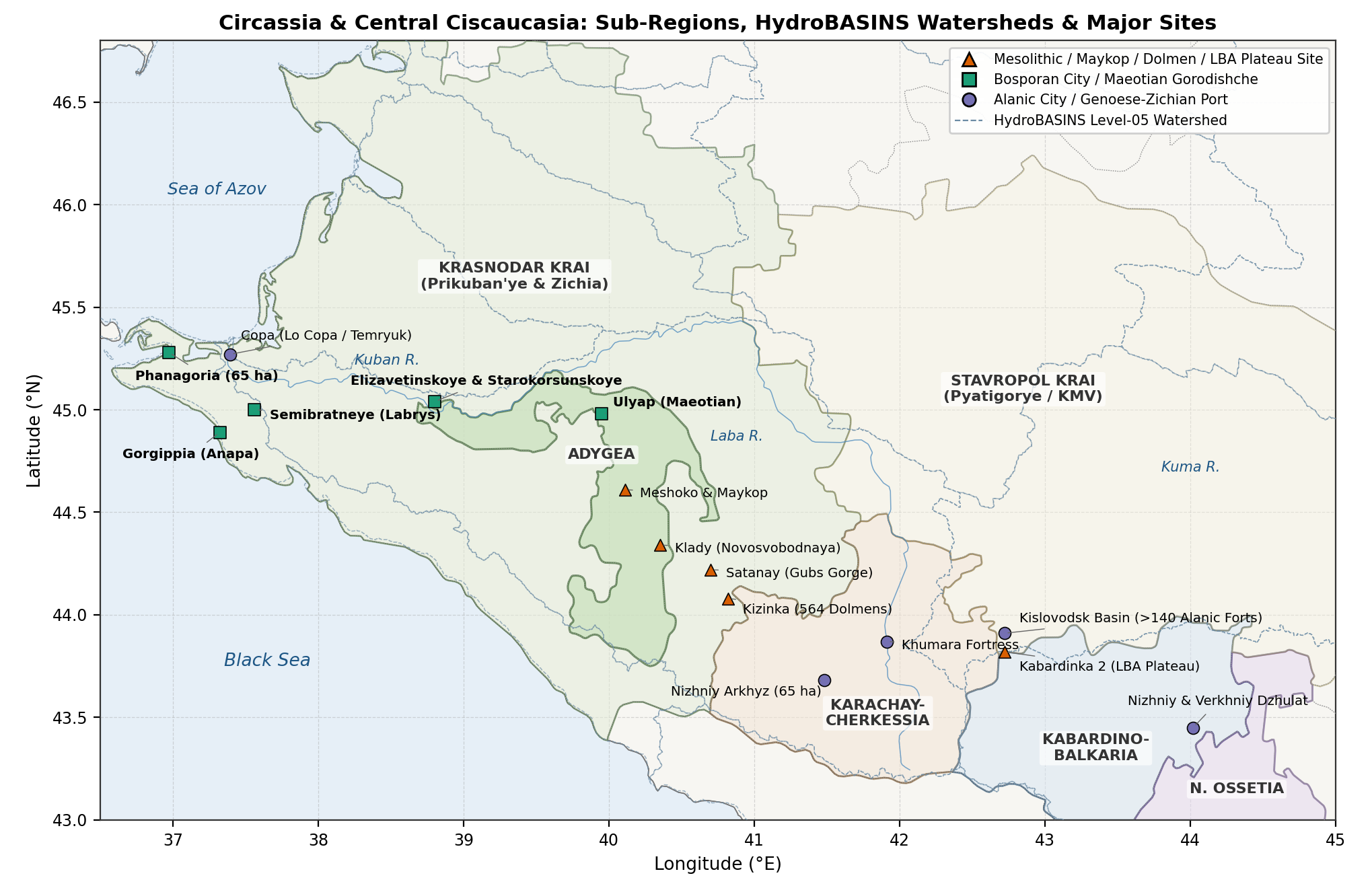
Stretching 650 km from the Taman Peninsula and the Kerch Strait (Cimmerian Bosporus) across the chernozem plains of the Kuban (Prikuban'ye) and the Sub-Elbrus volcanic plateaus to the Darial Gorge on the upper Terek, Northwestern and Central Ciscaucasia (122,9k km²) comprises five connected sub-regions (Figure 1 and Table 1):
- The Taman Peninsula, Black Sea Littoral (Zichia), and Lower/Middle Kuban Plain (Krasnodar Krai, 75,5k km²): Encompassing the Taman delta (Asiatic Bosporus), the narrow Black Sea coastal strip (Anapa to Sochi), the Azov reed-flats, and the fertile right- and left-bank Kuban chernozem plains. This corridor hosted the richest Early Bronze Age royal kurgans (Maykop, Staromyshastovskaya), >200 Classical Maeotian fortified towns (Elizavetinskoye, Starokorsunskoye, Semibratneye), the Greek polis cities of Phanagoria (65 ha) and Gorgippia (40 ha), 39 Genoese-Zichian trading ports (Matrega, Copa, Mapa, Maurocastro), the early modern Western Circassian tribes and principalities (Zhaney, Temirgoy, Bjedukh, Hatukay, Shapsug, Natukhai, Abadzekh, Ubykh), and, after 1792-1864, the administrative heartland of Kuban Oblast (Yekaterinodar) and Black Sea Governorate (Novorossiysk) [11][12][17][19][24].
- The Trans-Kuban Foothills and Dolmen Belt (Republic of Adygea, 7,8k km²): Drained by the Belaya, Laba, Fars, and Pshish rivers, Adygea contains the stratified Eneolithic stone fortresses (Meshoko, Yasenova Polyana), the eponymous Oshad kurgan of Maykop, the Klady (Novosvobodnaya) megalithic tombs, dense clusters of Bronze Age slab and trough dolmens (Kizinka, Deguako, Bogatyrskaya Polyana), the Maeotian sanctuary kurgans of Ulyap, and the core territory of the Temirgoy (Kemirgoy) and Hatukay principalities (modern Maykop Otdel) [1][4][6].
- The Upper Kuban, Zelenchuk, and Teberda Gorges (Karachay-Cherkessia, 14,3k km²): Controlling the Klukhor and Marukh passes into Abkhazia, this sub-region hosted the 8th-10th century fortress of Khumara (Хумаринское городище, 25 ha), the 10th-12th century metropolitan see of Alania at Nizhniy Arkhyz (Нижне-Архызское городище, 65 ha with three standing Byzantine stone churches), and the early modern territories of the Besleney Circassians, Abaza (Tapanta / Altykesek and Shkaraua), and Karachay (Карачай) in the Batalpashinsk Otdel [14][15][26][27].
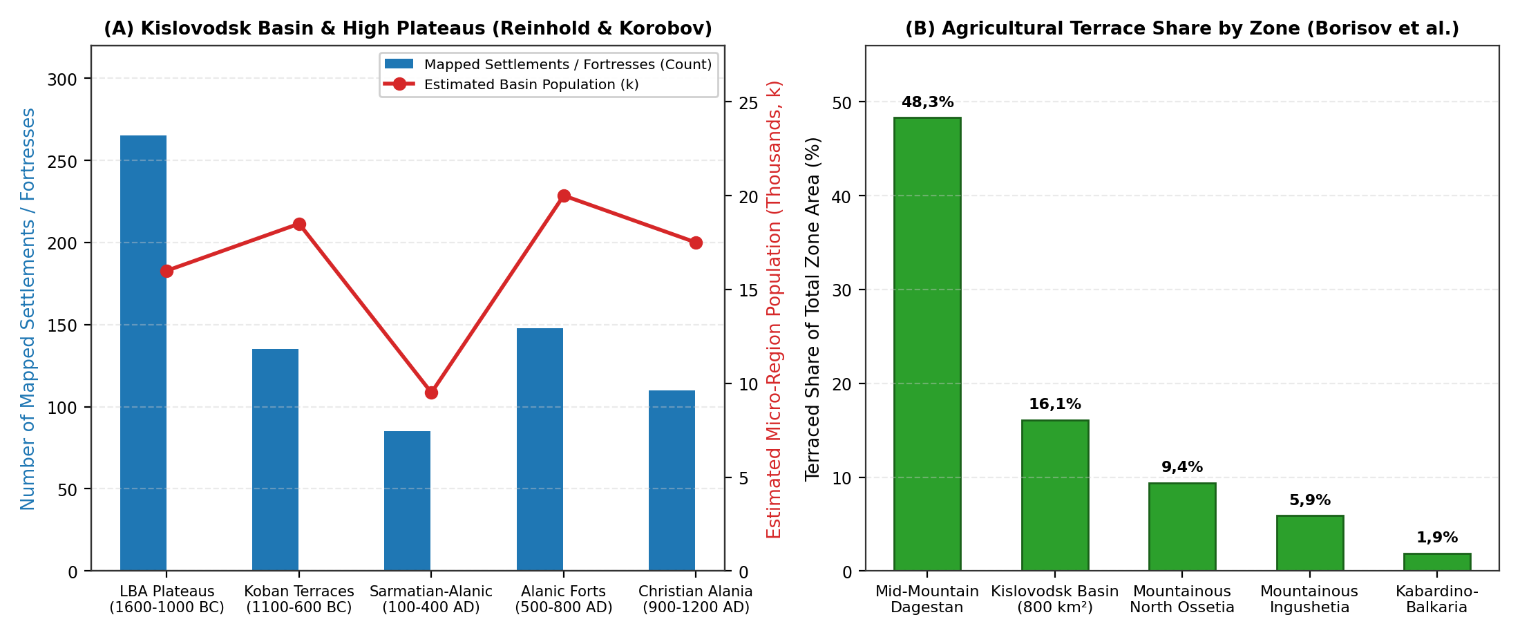
- The Kislovodsk Basin (Pyatigorye) and Sub-Elbrus High Plateaus (Kabardino-Balkaria [12,5k km²] + Pyatigorye / KMV [4,8k km²] = 17,3k km²): Between the Baksan-Malka-Cherek gorges and the Podkumok-Eshkakon limestone basin around Kislovodsk (800 km²), systematic surveys by Sabine Reinhold and D. S. Korobov (2004-2020) documented over 260 Late Bronze Age stone plateau settlements (1 400-2 400 m, e.g., Kabardinka 2), 16,1% terraced agricultural land coverage (Koban and Alanic periods), and over 140 Early Medieval Alanic promontory fortresses (5th-8th centuries AD) [8][9][28], succeeded by the Golden Horde city of Nizhniy Dzhulat (Нижний Джулат), the princely federation of Greater and Lesser Kabarda alongside the Five Balkar Mountain Societies, and the 19th-century Nalchik Okrug and Pyatigorsk/Kislovodsk spa towns [17][29][30].
- The Upper Terek and Darial Corridor (North Ossetia-Alania, 8,0k km²): Anchored by the eponymous Koban (Кобан) cemetery in the Gizeldon gorge, the Alanic-Golden Horde city of Verkhniy Dzhulat (Верхний Джулат / Tatartup / Dedyakov) at the Elkhotovo Gates, the Zmeyskaya catacomb necropolis, the four post-Timurid Ossetian mountain societies (Digor, Alagir, Kurtat, Tagaur), and the Russian fortress and administrative capital of Vladikavkaz (founded 1784) [31][32].
Methodology
Regional Subdivisions
| Sub-Regional Unit | Elevation | Area (km2) | River Basins | Key Archaeological and Historical Centres |
|---|---|---|---|---|
| 1. Krasnodar Krai (Taman, Black Sea Coast and Kuban Plain) | 0 to 3 256 m | 75,5k | Lower/Middle Kuban, Taman delta, Eya-Chelbas Azov steppe and Pontic rivers | Phanagoria, Gorgippia, Semibratneye, Elizavetinskoye, Yekaterinodar, Novorossiysk |
| 2. Republic of Adygea (Belaya-Laba Foothills and Dolmen Belt) | 50 to 3 238 m | 7,8k | Belaya, Laba, Fars, Kurdzhips and Gubs river valleys | Meshoko, Maykop (Oshad), Klady (Novosvobodnaya), Satanay, Kizinka, Ulyap |
| 3. Karachay-Cherkessia (Upper Kuban, Zelenchuk and Teberda) | 400 to 5 642 m | 14,3k | Upper Kuban, Bolshoy and Malyy Zelenchuk, Urup and Teberda | Nizhniy Arkhyz (65 ha), Khumara Fortress (25 ha), Batalpashinsk |
| 4. Kabardino-Balkaria and Pyatigorye / Kislovodsk Basin | 150 to 5 642 m | 17,3k | Podkumok-Kuma (Kislovodsk), Malka, Baksan, Chegem and Cherek | Sosruko, Kabardinka 2, Kislovodsk forts (>140), Nizhniy Dzhulat, Nalchik, Pyatigorsk |
| 5. North Ossetia-Alania (Upper Terek, Ardon and Darial Gorge) | 130 to 5 033 m | 8,0k | Upper Terek, Urukh, Ardon, Fiagdon, Gizeldon and Kambileyevka | Koban, Zmeyskaya, Verkhniy Dzhulat (Tatartup), Dargavs, Vladikavkaz |
| Total Circassia and Central Ciscaucasia | 0 to 5 642 m | 122,9k | Azov-Black Sea (Kuban) and Caspian (Kuma-Terek) drainage basins | Over 5 000 mapped prehistoric, classical, and medieval monuments |
Estimation Methods
To estimate regional population across 122,9k km² from 10000BC to 1900AD, we combine five quantitative methods:
- Late Bronze Age High-Plateau Stone Settlements and Koban Terraces (1600-500BC): Using Sabine Reinhold's inventory of >260 Late Bronze Age stone plateau villages (1 400-2 400 m; 10-36 double-row stone courtyard houses per village; 80-200 inhabitants per site) [8][33] and D. S. Korobov and A. V. Borisov's land-use study of the Kislovodsk basin (800 km², 16,1% terraced surface area capable of supporting 15,0k-25,0k inhabitants in that single basin alone) [9][28][34][35].
- Asiatic Bosporus Polis and Maeotian Fortified Town (Gorodishche) Estimates (500BC-300AD): Combining urban walled area (Phanagoria [65 ha], Gorgippia [40 ha], Hermonassa [25 ha], Semibratneye / Labrys [14 ha], Patraeus, Kepoi at 100-130 persons/ha) [12][13][36] with I. I. Marchenko's and N. V. Anfimov's survey of over 200 fortified Maeotian gorodishcha and open selishcha lining the Kuban terrace bluffs (2-15 ha each, plus the 200-ha Elizavetinskoye delta trading town) [11][37][38][39].
- Alanic Catchment and Fortification Estimates (400-1238AD): Applying Korobov's (2017) catchment model of >140 Early Medieval Alanic stone fortresses and >700 sites in the Kislovodsk basin (1,5-2,5 km spacing between forts; 12,0k-22,0k basin inhabitants) [9][16][40] alongside the Christian Alanic capital at Nizhniy Arkhyz (65 ha, 6,0k-10,0k inhabitants) [14][41], Khumara (25 ha) [15], Nizhniy Dzhulat, and Verkhniy Dzhulat (Tatartup) [31].
- 16th-18th-Century Ottoman, Crimean, French, and Russian Diplomatic Accounts (1500-1800AD): Cross-checking Giorgio Interiano (1502), Giovanni da Lucca (1625), Evliya Çelebi (1666-1667), Xavier Glavani (1724), Johann Anton Güldenstädt (1770-1773), and P. S. Pallas (1793) alongside Russian Posolskiy Prikaz registers (1552-1700) analysed by V. K. Gardanov [17], E. N. Kusheva [29], S. Kh. Khotko [18][19][30][42][43], and V. V. Trepalov [20].
- 19th-Century Military-Statistical Surveys, Muhajir Emigration Registers, and the 1897 Census (1800-1900AD): Combining General A. P. Berger's (1860-1882) and T. Kh. Kumykov's (1994) archival records of the 1858-1865 Circassian and Abaza muhajir deportations [22][23], V. M. Kabuzan's (1996) ethnostatistical reconstructions of Ciscaucasia (1795-1897) [21], and the 1897 First All-Russian Imperial Census volumes for Kuban Oblast (Vol. 65: 1 918 881 inhabitants), Black Sea Governorate (Vol. 70: 57 478 inhabitants), and the western okrugs of Terek Oblast (Vol. 68: Nalchik, Vladikavkaz, Pyatigorsk, and Mozdok) [24][25][44].
Historical Overview
Mesolithic, Neolithic, and Eneolithic Villages: Satanay, Sosruko, and Meshoko (10000 - 3700BC)
During the Terminal Pleistocene and Early Holocene (10000-5000BC), hunter-gatherer bands occupied karst rock-shelters across both the northwestern foothills (Satanay / Gubskiy Naves No. 7, Chygai, Dvoinaya, and Kasozhskaya caves in the Gubs gorge of Adygea/Krasnodar) and the central volcanic canyons (Sosruko and Badynoko rock-shelters in the Baksan gorge of Kabardino-Balkaria) [1][2][3][45]. Stratified hearths at Sosruko (Layers 7-4) and Satanay preserve geometric obsidian and flint microliths, bone harpoons, edible land snails (Helix), and bones of Caucasian tur, wild boar, and red deer, supporting a gradual regional rise from 2,0k (10000BC) to 7,5k (6000BC) and 13,0k (5000BC).
In the mid-5th millennium BC (Eneolithic, 4500-3700BC), settled farmers established the Meshoko-Svobodnoe (Darkveti-Meshoko) culture in the Belaya and Kuban foothills [1][4][5]:
- Fortified Promontory Villages (Meshoko, Yasenova Polyana, Skala, Myskhako) and Steppe Settlements (Svobodnoe): Excavated by A. A. Formozov and A. D. Rezepkin, Meshoko (Мешоко) occupied a cliff-lined limestone plateau in Adygea protected by a 150-metre-long, 4-metre-thick dry-stone defensive wall, while Svobodnoe on the Kuban plain was enclosed by a circular ditch-and-palisade system (~2,5 ha, 25-40 rectangular wattle-and-daub houses) [1][4][5]. Subsisting on domesticated cattle, pigs (up to 30-40% at Meshoko), and emmer and barley cultivation, and participating in long-distance copper and obsidian exchange (as seen in the Nalchik Eneolithic cemetery of 121 ochre-stained burials in Kabardino-Balkaria), total regional population reached 30,0k (22,0k-38,0k) by 4000BC.
Early and Middle Bronze Ages: The Maykop Culture and Western Caucasian Dolmens (3700 - 1600BC)
Between 3700 and 2900BC, Northwestern and Central Ciscaucasia formed the core of the Maykop-Novosvobodnaya culture (Майкопско-новосвободненская общность), documented in the monographs and radiocarbon chronologies of S. N. Korenevskiy, R. M. Munchaev, and V. A. Trifonov [4][46][47][48][49]:
- Maykop Settlements (Galyugay I-III, Sereginskoye, Chekon, Bolshoy Tegink) and Royal Kurgans (Oshad, Klady, Kishpek, Marinskaya): Excavations of open river-terrace settlements along the Kuban and Terek (Galyugay I, 6-8 ha with large circular sunken-floor wattle-and-daub dwellings of 50-80 m²) demonstrate that the great royal kurgans - such as the 11-metre-high Maykop (Oshad) kurgan (1897) and the Klady (Novosvobodnaya) megalithic two-chamber stone tombs - were supported by a wide network of wheel-made pottery-producing farming villages [4][46][47]. Palaeogenetic (aDNA) and craniological studies confirm strong continuity among Caucasian Hunter-Gatherer (CHG) and Anatolian-Iranian Neolithic farming populations alongside steppe exchange [50][51]. By 3000BC, regional population reached 70,0k (55,0k-85,0k).
- The Western Caucasian Dolmen Culture (Дольменная культура Западного Кавказа, 2900-1400BC): Across the wooded mountain valleys from the Taman-Anapa coast (Pshekh, Pshada, Dzhubga) to the Belaya and Laba headwaters (Kizinka, Deguako, Bogatyrskaya Polyana), V. I. Markovin and V. A. Trifonov catalogued between 2 300 and 3 000 megalithic stone dolmens (slab, composite, trough-shaped, and monolithic tombs weighing 15-50 tonnes; clustered in cemeteries of up to 564 dolmens at Kizinka and >300 at Bogatyrskaya Polyana) [6][7][52][53][54]. Excavations at the fortified settlement of Deguako-Dakhovskoye and collective chamber burials (15-70 individuals per dolmen) attest to settled mountain-forest communities, which - together with the North Caucasian (Severokavkazskaya) and Piedmont Catacomb cultures of Central Ciscaucasia - supported 100,0k (80,0k-120,0k) inhabitants by 2000BC.
Late Bronze and Early Iron Ages: High-Plateau Stone Villages and Koban Terraces (1600 - 400BC)
During the mid-2nd millennium BC (1600-1000BC), Russian-German surveys led by Sabine Reinhold, D. S. Korobov, and A. B. Belinskiy (2004-2017) identified a major Late Bronze Age high-mountain plateau settlement phase (1 400-2 400 m elevation) stretching 140 km across the sub-alpine limestone plateaus north of Mount Elbrus (Kislovodsk / Pyatigorye, Karachay-Cherkessia, and Kabardino-Balkaria) [8][9][55]:
- Over 260 Planned Stone Plateau Villages (Kabardinka 2, Pravoberezhnaya Berezovaya, Tambukan): Using aerial photography, geomagnetic survey, and excavations at Kabardinka 2, Reinhold et al. (2017) mapped >260 permanent stone-built villages laid out in symmetrical linear or oval plans around central livestock enclosures (10-36 double-row stone houses per village; 80-200 inhabitants per settlement; 20,0k-35,0k high-plateau inhabitants during 1500-1100BC) (Figure 3A) [8][56].
- The Western and Central Koban Culture (1100-400BC): Following climate cooling around 1000-900BC, communities moved 400-600 m down into the mid-mountain valleys (800-1 300 m), establishing classic Koban Culture (Кобанская культура) settlements and cemeteries (Koban, Tli, Verkhnyaya Rutkha, Kumbulta in Ossetia; Bylym, Zayukovo in Kabardino-Balkaria; the Kislovodsk basin; Tereze and Kyzyl-Kala in Karachay-Cherkessia; and Proto-Maeotian sites on the Kuban plain) [9][10]. In the 800 km² Kislovodsk basin alone, >130 Koban settlements built agricultural lynchet terraces across 16,1% of the landscape (Figure 3B) [9][28][34], raising total regional population from 160,0k (1500BC) to 225,0k (190,0k-260,0k) by 1000BC.
Classical Antiquity: The Asiatic Bosporus and Maeotian Fortified Towns (500BC - 350AD)
Between the 6th century BC and the 3rd century AD, Northwestern Ciscaucasia supported a dense population through the commercial ties between the Greek cities of the Asiatic Bosporus (Азиатский Боспор) and the settled farming Maeotian (Меоты) tribes of the Kuban basin [11][12][13][36][38][39][57]:
- Polis Cities and Rural Territory (Chora) of the Asiatic Bosporus (Taman and Anapa): Founded by Teian colonists c. 543BC, Phanagoria (Фанагория) became the eastern capital of the Bosporan Kingdom (65 ha walled upper and lower city plus >22 ha submerged in Taman Bay and >600 kurgans; 10,0k-15,0k urban residents) [12][36]. Gorgippia (Горгиппия / Anapa, 40 ha; 6,0k-9,0k residents), Hermonassa (Taman, 25 ha), Kepoi, Patraeus, and the Sindian capital Labrys (Semibratneye gorodishche, 14 ha) were surrounded by >250 rural farmsteads (chora) exporting grain and salted fish to Athens and Pontus (55,0k-75,0k total inhabitants in the Asiatic Bosporus) [13][57].
- The Maeotian Fortified Town Network (>200 Gorodishcha on the Kuban and Azov Steppes): Along the high right-bank terrace of the Kuban from Ust-Labinsk to Krasnodar and across the Laba-Belaya and Ponura-Kirpili rivers, N. V. Anfimov and I. I. Marchenko mapped over 200 fortified Maeotian gorodishcha (Elizavetinskoye [200 ha outer enclosure / 12 ha inner citadel], Starokorsunskoye No. 2, Pashkovskoye, Voronezhskoye, Ust-Labinskoye), each surrounded by 3-8 open agricultural villages (selishcha) and flat cemeteries containing 500-3 000+ graves [11][37][38][58]. Strabo (Geography 11,5.8) recorded that the neighbouring Siraces (Сираки) and Aorsi (Аорсы) of the Kuban-Kuma steppes could field 20 000 and 200 000 horsemen respectively. Combined with the Sarmatian-Koban population of Central Ciscaucasia, total regional population reached 310,0k (500BC) and 340,0k (290,0k-390,0k) at 1AD, before declining to 260,0k in 400AD during the Gothic and Hunnic wars (c. 370-375AD).
Early and High Middle Ages: Western Alania, Zichia, and the Mongol and Timurid Invasions (400 - 1450AD)
Between the 5th and early 13th centuries AD, population grew across both the Christian Kingdom of Alania (Алания) in Central Ciscaucasia and the coastal and foothill confederation of Zichia / Kasogia (Зихия / Касогия) in the northwest:
- The Kislovodsk Basin Fortress Network (5th-8th centuries AD): As mapped by D. S. Korobov (2012, 2017, 2023) and G. E. Afanasyev, over 140 single-layer stone promontory castles (Rim-Gora, Klin-Yar, Khasaut) and >700 total sites occupied the 800 km² Kislovodsk basin (15,0k-22,0k inhabitants in that single basin) [9][16][33][35][40].
- Christian Alanic Metropolitan Cities (9th-13th centuries AD):
- Nizhniy Arkhyz (Нижне-Архызское городище, Bolshoy Zelenchuk valley, 1 150 m): Extending 3,5 km along a mountain valley behind three stone defensive walls (65 ha intramural area), Nizhniy Arkhyz served as the seat of the Byzantine Metropolitan of Alania (established 914-916AD under Patriarch Nicholas Mystikos). Excavations by V. A. Kuznetsov documented three standing cross-domed stone cathedrals (North, Middle, and South Zelenchuk churches), 11 smaller chapels, paved stone streets, residential quarters, and >1 000 stone-cist and catacomb burials, supporting 6,0k-10,0k urban inhabitants [14][27][31][41].
- Khumara (Хумаринское городище, upper Kuban, 25 ha): Protected by a 5-7 m thick ashlar stone wall with 19 towers and Turkic runic inscriptions (3,0k-5,0k inhabitants) [15].
- Illichevskoye (Ильичевское городище, Otradnaya district, 45 ha with 6 stone churches), Nizhniy Dzhulat (Mayskiy, Kabardino-Balkaria), and Verkhniy Dzhulat (Tatartup / Dedyakov, North Ossetia, >35 ha with Christian churches, two Golden Horde minarets, and a brick mosque) [31][32][59].
- Zichia, Kasogia, and Taman (Tmutarakan / Matrega): In Krasnodar and Adygea, cremation-and-inhumation kurgan fields (Borisovskiy, Dyurso, Moldavanovskiy, Kazazovo with >800 burials) and the Taman port of Tmutarakan (Matrega) supported a dense Zichian-Kasogian farming population (195,0k in Krasnodar + 28,0k in Adygea by 1200AD), lifting total regional population to 470,0k (410,0k-530,0k) around 1200AD [19][60][61].
- The Mongol (1238-1278) and Timurid (1395-1396) Campaigns: While Batu and Möngke devastated central Alania in 1238-1240 (and Mengu-Timur stormed Dedyakov / Verkhniy Dzhulat in 1278), an active urban network persisted under Golden Horde rule at Verkhniy Dzhulat, Nizhniy Dzhulat, and Madzhar (380,0k in 1300AD) until Timur's 1395 campaign burned the Circassian Kuban forests, stormed the Elbrus gorges (Buriberd, Kula, Taus), and destroyed both Dzhulats [31][42][43][62]. Regional population fell to 330,0k (285,0k-375,0k) in 1400AD, while survival of Alanic communities in the Digor, Alagir, Kurtat, Tagaur, and Balkar-Karachay gorges was accompanied by the 15th-century eastward expansion of the Kabardian Circassians across Pyatigorye, Baksan, and the Terek bend [17][42][63].
Early Modern Circassia, Kabarda, Abaza, Karachay-Balkaria, Ossetia, and the Lesser Nogais (1500 - 1700AD)
Between 1450 and 1700AD, the recovery of Black Sea, Crimean, Ottoman, and Russian Terki-Astrakhan trade routes carried total regional population from 415,0k (1500AD) to 505,0k (1600AD) and 600,0k (530,0k-680,0k) by 1700AD (Figure 4 and Table 2).
Drawing on the Italian, Ottoman, French, and Russian accounts analysed by V. K. Gardanov [17], E. N. Kusheva [29], N. G. Volkova [26], S. Kh. Khotko [18][19][64][65][66], and V. V. Trepalov [20]:
- Western Circassia (Западная Черкесия - Krasnodar Krai and Adygea, 300,0k-350,0k):
- Giorgio Interiano (1502) noted that the Circassians could muster >20 000 noble heavy cavalry (uzden and pshi) plus peasant infantry; in 1666-1667, the Ottoman traveller Evliya Çelebi (Seyahatnâme, Vol. VII) travelled across the Circassian lands from Taman and Anapa through Shegak, Zhaney, Hatukay, Temirgoy (Kemirgoy / Bolotoko), Bjedukh, Abadzekh, and Kabarda, recording 3 000 to 10 000 armed warriors per principality (~70 000-85 000 total fighting men across all Circassian tribes) [17][18].
- In 1724, the French consul in Crimea Xavier Glavani (Description de la Circassie) compiled a district-by-district household (maison) count across 14 Western and Central Circassian provinces (Temirgoy: >5 000 households in 40 large villages; Besleney: 1 500 households; Bjedukh, Hatukay, Zhaney, Shapsug, Natukhai, Abadzekh), confirming 52,0k-62,0k Western Circassian households (300,0k-350,0k inhabitants) [17][18][65].
- Greater and Lesser Kabarda (Большая и Малая Кабарда, 115,0k-145,0k):
- Following the 1557 diplomatic alliance with Ivan IV (Temryuk Idarovich), Russian Posolskiy Prikaz embassies (1589-1700) documented the four princely houses of Greater Kabarda (Kaytukino, Atazhukino / Hatokshoko, Misostovo, Bekmurzino along the Malka, Baksan, Cherek, and Pyatigorye) and Lesser Kabarda (Talostanovo and Dzholyakhstanovo / Mudarovo along the Terek bend), capable of fielding 10 000-15 000 noble cavalry and 20 000 infantry (19,0k-24,0k households across >150 princely and uzden kabaki; 115,0k-145,0k inhabitants) [17][29][30][67].
- Lesser Nogai Horde (Малая Ногайская Орда / Kazyev Ulus) and Taman/Azov Garrisons (50,0k-65,0k):
- Founded by Ghazi Mirza in the 1550s across the Kuban-Azov steppes (Prikuban'ye) and Pyatigorye (9,0k-11,0k kibitkas/households + Ottoman garrisons at Azov, Temryuk, Taman, and Anapa; 50,0k-65,0k inhabitants) [20].
- Abaza (Абазины - Tapanta / Altykesek and Shkaraua, 38,0k-47,0k): Inhabiting the upper Kuban, Zelenchuk, Urup, and Laba gorges (Bibard, Loov, Dudaruq, Klych, Kech, Tram kabaki; 6,5k-8,5k households) [26][29].
- Four Ossetian Mountain Societies (Tagaur, Kurtat, Alagir, Digor, 44,0k-54,0k): Occupying the fortified stone tower villages (Dargavs, Tsmiti, Nuzal, Zadalesk) of North Ossetia (7,0k-9,0k households) [26][32].
- Karachay and Five Balkar Mountain Societies (Baksan / Urusbiev, Chegem, Khulam, Bezengi, Balkar / Malkar, 25,0k-32,0k): 4,0k-5,2k mountain stone homesteads around Mount Elbrus [26][29].
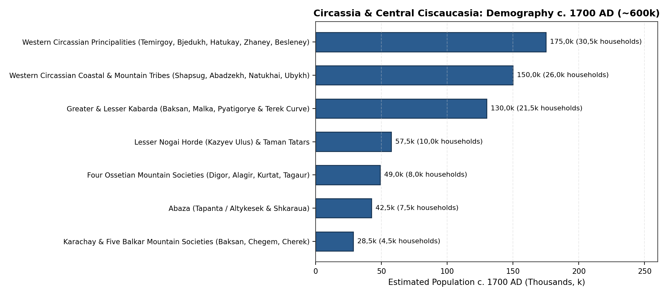
| Sub-Ethnic Group / Principality Union | Primary Sub-Region | Households (Dvors/Kibitkas) | Militia (Cavalry and Foot) | Estimated Population |
|---|---|---|---|---|
| Western Circassian Principalities (Temirgoy, Bjedukh, Hatukay, Zhaney, Besleney, Mamkhegh) | Krasnodar, Adygea and W. Karachay-Cherkessia | 28,0k - 33,0k | 25,0k - 32,0k | 160,0k - 190,0k |
| Western Circassian Coastal and Mountain Tribes (Shapsug, Abadzekh, Natukhai, Ubykh) | Black Sea Littoral (Anapa-Sochi) and Western Slopes | 24,0k - 28,0k | 22,0k - 28,0k | 135,0k - 165,0k |
| Greater and Lesser Kabarda (Atazhukino, Kaytukino, Misostovo, Bekmurzino, Talostanovo, Dzholyakhstanovo) | Kabardino-Balkaria, Pyatigorye and Terek Curve | 19,0k - 24,0k | 20,0k - 28,0k | 115,0k - 145,0k |
| Lesser Nogai Horde (Kazyev Ulus) and Ottoman Taman-Temryuk-Anapa Ports | Azov-Kuban Steppe (Krasnodar) and Taman | 9,0k - 11,0k | 10,0k - 14,0k | 50,0k - 65,0k |
| Four Ossetian Mountain Societies (Digor, Alagir, Kurtat, Tagaur) | North Ossetia-Alania (Upper Terek and Ardon) | 7,0k - 9,0k | 7,0k - 9,5k | 44,0k - 54,0k |
| Abaza (Tapanta / Altykesek Six-Clan Federation and Shkaraua Mountain Clans) | Karachay-Cherkessia and E. Adygea Gorges | 6,5k - 8,5k | 6,0k - 8,0k | 38,0k - 47,0k |
| Karachay (Upper Kuban) and Five Balkar Societies (Baksan, Chegem, Khulam, Bezengi, Malkar) | High-Mountain Karachay-Cherkessia and Kabardino-Balkaria | 4,0k - 5,2k | 4,0k - 5,5k | 25,0k - 32,0k |
| Adopted Regional Benchmark (Circassia and Central Ciscaucasia, 122,9k km2) | All 5 Sub-Regions (122,9k km2) | 97,5k - 118,7k | 94,0k - 125,0k | 600,0k (530,0k - 680,0k) |
The Eighteenth and Nineteenth Centuries (1700 - 1900AD)
Between 1700 and 1900AD, Northwestern and Central Ciscaucasia underwent the most dramatic demographic and ethnic transformation in its history [21][22][23][25][26]:
- Eighteenth-Century Growth, the Azov-Mozdok Line, and the Black Sea Cossack Settlement (1700-1800AD): During the first three quarters of the 18th century, indigenous Circassian, Kabardian, Abaza, Karachay-Balkar, and Ossetian populations expanded steadily from 600,0k in 1700AD to 670,0k (590,0k-750,0k) in 1750AD [17][21]. Following the Russo-Turkish War of 1768-1774 (Treaty of Küçük Kaynarca) and the annexation of the Crimean Khanate (1783), the Russian Empire constructed the Azov-Mozdok Fortified Line (1777-1780, including Stavropol, Georgievsk, Konstantinogorsk/Pyatigorsk, and Vladikavkaz in 1784), crushed the Kuban Nogai Horde under Suvorov in 1783, and in 1792-1793 resettled ~25,0k former Zaporozhian Cossacks (Black Sea Cossack Host / Chernomorskoye kazach'ye voysko) onto the right-bank Kuban plain between the Taman Peninsula and Ust-Labinsk (founding Yekaterinodar [Krasnodar] in 1793), followed by the Old Line Cossack regiments along the middle and upper Kuban (1794-1804) [21][25]. Total population across the five sub-regions reached 740,0k (650,0k-830,0k) in 1800AD.
- Plague in Kabarda (1804-1812), the Caucasian War (1817-1864), and the Circassian Muhajir Expulsion (1860-1864): During the early 19th century, Greater and Lesser Kabarda suffered a severe demographic collapse caused by the 1804-1812 plague epidemics, Russian military campaigns (1804, 1810, 1822, when General Yermolov founded Nalchik), and the migration of "fugitive Kabardians" (beglyye kabardintsy) across the Kuban to join the Western Adyghe: Kabardian population fell from >150,0k-200,0k in the 1780s to ~35,0k-40,0k in the 1830s [21][26][67]. In Western Circassia, the construction of the Black Sea Coastline Forts (1837-1839), the Laba and Belaya fortified lines (Founding of Maykop in 1857), and the final Russian offensive of 1859-1864 (ending at Kbaada / Krasnaya Polyana on 21 May 1864) culminated in the mass expulsion (muhajirism) of the Western Circassian and Abaza populations to the Ottoman Empire [22][23][66]. Official Russian embarkation logs compiled by A. P. Berger (1882) recorded 493 194 mountaineers deported through Black Sea ports (Anapa, Novorossiysk, Tuapse, Sochi, Adler) between 1858 and 1865 - including virtually the entire Ubykh, Natukhai, and coastal Shapsug populations, the majority of the Abadzekh, Temirgoy, Bjedukh, Hatukay, Besleney, and Shkaraua/Tapanta Abaza, and Kuban Nogais - while T. Kh. Kumykov (1994) and S. Kh. Khotko estimate total Circassian and Abaza demographic loss and emigration in 1858-1865 at 450,0k-600,0k+ [22][23][66]. Only ~50,0k-65,0k Western Circassians (settled in lowland villages of the Ekaterinodar and Maykop otdels) and ~9,0k-12,0k Abaza remained on the northwestern slopes by 1865 [21][26]. Because Slavic and Cossack military colonisation of the right-bank Kuban plain and Pyatigorye was already well underway by mid-century, total population across the five sub-regions stood at 920,0k (820,0k-1 020,0k) in 1850AD [21][25].
- Kuban Cossack and Slavic Peasant Colonisation and the 1897 Imperial Census: Following the 1860 formation of Kuban Oblast (uniting the Black Sea and Caucasus Line Cossack hosts into the Kuban Cossack Host), the 1861 Emancipation of the Serfs, the 1862 law on the settlement of the Western Caucasus foothills, and the construction of the Rostov-Vladikavkaz Railway (1875) and Tikhoretsk-Novorossiysk line (1888), over one million Russian and Ukrainian peasants (inogorodniye) and Cossacks poured into the fertile Kuban plains and foothill valleys [21][25]. In the First General Census of the Russian Empire (28 January 1897) [24][44]:
- Kuban Oblast (94,3k km², encompassing modern Krasnodar Krai, Adygea, and Karachay-Cherkessia / Batalpashinsk Otdel) recorded 1 918 881 inhabitants (908,8k Ukrainians/Little Russians [47,4%], 816,7k Great Russians [42,6%], 38,5k Western Circassians & Adyghe, 26,9k Karachays, 20,1k Germans, 14,3k Greeks, 13,9k Armenians, and 12,4k Abaza and Nogais), with Yekaterinodar (Krasnodar) reaching 65 606 residents, Maykop 34 327, and Yeysk 35 414 [24][25].
- Black Sea Governorate (Chernomorskaya guberniya, from Anapa/Novorossiysk to Sochi) recorded 57 478 inhabitants (including 16 897 in the port of Novorossiysk) [24].
- In Central Ciscaucasia (western Terek Oblast), the Nalchik Okrug (Kabarda and Balkaria) recorded 102 908 inhabitants (84,1k Kabardians and 23,2k Balkars/Mountain Tatars across the oblast), the Pyatigorsk (KMV) Otdel recorded ~125,0k inhabitants (centred on Pyatigorsk [18 440] and Kislovodsk), and North Ossetia (the Vladikavkaz Okrug plus Ossetian villages of the Mozdok/Sunzha border) recorded ~215,0k inhabitants (including 43 740 in Vladikavkaz city and 96,6k ethnic Ossetians in Terek Oblast) [21][24][44].
- Summing all five sub-regions within their modern boundaries yields a total 1900AD population of 2 420,0k (2,42M; range 2,30M - 2,55M, or 19,69 persons/km²): 1 650,0k in Krasnodar Krai, 215,0k in Adygea (Maykop lowland & foothill sector), 165,0k in Karachay-Cherkessia (Batalpashinsk sector), 235,0k in Kabardino-Balkaria & Pyatigorye/KMV, and 155,0k in North Ossetia-Alania (excluding the Ingush Nazran sector counted in the Chechnya-Ingushetia review) [21][24].
Limitations
- Seasonal Steppe Mobility on the Kuban-Kuma Plain: Unlike the permanent stone auls of the mountain gorges, the Azov-Kuban and Kuma steppes hosted mobile pastoral groups (Scythians, Siraces, Kipchaks, Lesser Nogais) whose winter camps (kochev'ya) along the Kuban and Kuma shifted seasonally across the Don-Manych watershed [11][20].
- Submerged Coastal Sectors of the Taman Peninsula: Because relative Black Sea and Azov sea levels rose by ~3,5-4,0 m since the 1st millennium BC (Phanagorian Transgression), roughly one-third of ancient Phanagoria, Patraeus, and Korokondame now lies beneath Taman Bay, requiring bathymetric area adjustments when estimating Classical Bosporan urban populations [12][57].
- Unregistered Wartime Mortality and Clandestine Boat Crossings (1858-1865): While Russian port commissions registered 493,2k muhajirs embarking at designated Black Sea ports [23], unrecorded departures on Ottoman feluccas along the Abkhaz-Ubykh-Shapsug coast and typhus mortality in coastal camps mean that pre-1860 Western Circassian population totals carry an uncertainty range of ~15% [22][66].
Conclusion
Spanning 122,9k km² from the Kerch Strait to the Darial Gorge, Historical Circassia and Central Ciscaucasia supported the largest population in the North Caucasus throughout the last twelve millennia (2,0k in 10000BC -> 70,0k under the Maykop Culture in 3000BC -> 225,0k during the Late Bronze and Koban plateau and terrace expansion in 1000BC -> 340,0k in the Classical Bosporan-Maeotian era at 1AD -> 470,0k at the Alanic-Zichian medieval peak in 1200AD -> 600,0k by 1700AD -> 740,0k by 1800AD). In the 19th century, the expulsion of the majority of the indigenous Western Circassian and Abaza population in 1860-1864 and the subsequent influx of over 1,7 million Kuban Cossacks and Slavic agrarian settlers transformed the demographic profile of the region, raising its population to 2 420,0k (2,42M) by 1900AD. Combining all three North Caucasian review regions (Dagestan: 690,0k, Chechnya-Ingushetia: 350,0k, and Circassia and Central Ciscaucasia: 2 420,0k) yields a total North Caucasus population of 1 188,0k (1,19M) at 1700AD and 3 460,0k (3,46M) at 1900AD across 194,0k km².
Appendix
Population Estimates
| Benchmark | Krasnodar (75,5k km2) | Adygea (7,8k km2) | Karachay-Cherkessia (14,3k km2) | Kabardino-Balkaria and KMV (17,3k km2) | North Ossetia (8,0k km2) | Total Midpoint | Uncertainty Range [Low - High] | Density (p/km2) |
|---|---|---|---|---|---|---|---|---|
| 10000BC | 0,90k | 0,30k | 0,25k | 0,35k | 0,20k | 2,0k | 1,2k - 3,0k | 0,02 |
| 8000BC | 1,60k | 0,50k | 0,45k | 0,60k | 0,35k | 3,5k | 2,2k - 5,0k | 0,03 |
| 6000BC | 3,50k | 1,10k | 0,95k | 1,25k | 0,70k | 7,5k | 5,0k - 10,5k | 0,06 |
| 5000BC | 6,0k | 2,0k | 1,6k | 2,2k | 1,2k | 13,0k | 9,0k - 18,0k | 0,11 |
| 4000BC | 14,0k | 4,8k | 3,5k | 5,0k | 2,7k | 30,0k | 22,0k - 38,0k | 0,24 |
| 3000BC | 34,0k | 11,0k | 8,0k | 11,5k | 5,5k | 70,0k | 55,0k - 85,0k | 0,57 |
| 2000BC | 46,0k | 15,0k | 12,0k | 18,0k | 9,0k | 100,0k | 80,0k - 120,0k | 0,81 |
| 1500BC | 64,0k | 19,0k | 24,0k | 35,0k | 18,0k | 160,0k | 135,0k - 190,0k | 1,30 |
| 1000BC | 92,0k | 24,0k | 32,0k | 48,0k | 29,0k | 225,0k | 190,0k - 260,0k | 1,83 |
| 500BC | 155,0k | 32,0k | 35,0k | 55,0k | 33,0k | 310,0k | 260,0k - 360,0k | 2,52 |
| 1AD | 175,0k | 35,0k | 38,0k | 58,0k | 34,0k | 340,0k | 290,0k - 390,0k | 2,77 |
| 400AD | 110,0k | 22,0k | 38,0k | 56,0k | 34,0k | 260,0k | 220,0k - 300,0k | 2,12 |
| 600AD | 130,0k | 24,0k | 48,0k | 72,0k | 41,0k | 315,0k | 270,0k - 360,0k | 2,56 |
| 800AD | 148,0k | 26,0k | 55,0k | 80,0k | 46,0k | 355,0k | 305,0k - 405,0k | 2,89 |
| 1000AD | 178,0k | 27,0k | 68,0k | 98,0k | 59,0k | 430,0k | 375,0k - 485,0k | 3,50 |
| 1200AD | 195,0k | 28,0k | 72,0k | 108,0k | 67,0k | 470,0k | 410,0k - 530,0k | 3,82 |
| 1300AD | 165,0k | 25,0k | 56,0k | 82,0k | 52,0k | 380,0k | 330,0k - 430,0k | 3,09 |
| 1400AD | 150,0k | 24,0k | 46,0k | 66,0k | 44,0k | 330,0k | 285,0k - 375,0k | 2,69 |
| 1500AD | 190,0k | 32,0k | 54,0k | 92,0k | 47,0k | 415,0k | 365,0k - 465,0k | 3,38 |
| 1600AD | 232,0k | 40,0k | 63,0k | 122,0k | 48,0k | 505,0k | 445,0k - 565,0k | 4,11 |
| 1700AD | 275,0k | 48,0k | 72,0k | 156,0k | 49,0k | 600,0k | 530,0k - 680,0k | 4,88 |
| 1750AD | 310,0k | 54,0k | 78,0k | 172,0k | 56,0k | 670,0k | 590,0k - 750,0k | 5,45 |
| 1800AD | 365,0k | 62,0k | 85,0k | 160,0k | 68,0k | 740,0k | 650,0k - 830,0k | 6,02 |
| 1850AD | 520,0k | 75,0k | 95,0k | 140,0k | 90,0k | 920,0k | 820,0k - 1 020,0k | 7,49 |
| 1900AD | 1 650,0k | 215,0k | 165,0k | 235,0k | 155,0k | 2 420,0k | 2 300,0k - 2 550,0k | 19,69 |
Sources
1.Formozov, A. A. Kamennyy vek i eneolit Prikuban'ya [The Stone Age and Eneolithic of the Kuban Region]. Nauka, 1965.
2.Leonova, E. V. "Chronology and Periodization of the Late Upper Paleolithic and Mesolithic of the Northwestern Caucasus." Quaternary International, vol. 587, 2021, pp. 112-126.
3.Golovanova, L. V., et al. "Epipaleolit i mezolit Tsentral'nogo Kavkaza: novyye dannyye po groty Sosruko (Priehl'brus'ye)." Rossiyskaya Arkheologiya, no. 2, 2020, pp. 7-23.
4.Korenevskiy, S. N. Drevneyshiye zemledel'tsy i skotovody Predkavkaz'ya: Maykopsko-novosvobodnenskaya obshchnost'. Nauka, 1995.
5.Korenevskiy, S. N. "Poseleniye eneoliticheskoy epokhi Predkavkaz'ya, Yasenova Polyana i kul'tura nakol'chatoy zhemchuzhnoy keramiki Predkavkaz'ya [The Eneolithic Settlement of Yasenova Polyana]." Problemy Istorii, Filologii, Kul'tury, no. 21, 2008, pp. 3-39, Archived PDF (korenevskiy_s_n_2008_poselenie_eneoliticheskoy_epohi_predkavkazya_yaseneva.pdf).
6.Trifonov, V. A. "Sumarnyye otsenki trudozatrat i demograficheskogo potentsiala stroiteley dol'menov Zapadnogo Kavkaza." Arkheologicheskiye Vesti, vol. 8, 2001, pp. 87-98.
7.Markovin, V. I. Dol'meny Zapadnogo Kavkaza [Dolmens of the Western Caucasus]. Nauka, 1978.
8.Reinhold, S., et al. Landschaftsarch\"aologie im Nordkaukasus: Studien zu einer neu entdeckten bronzezeitlichen Kulturlandschaft im Hochgebirge des Nordkaukasus. Habelt-Verlag, 2017.
9.Korobov, D. S. Sistema rasseleniya alan Tsentral'nogo Predkavkaz'ya v I tys. n.e. (landshaftnaya arkheologiya Kislovodskoy kotloviny). Nestor-Istoriya, 2017.
10.Kozenkova, V. I. Kobanskaya kul'tura. Zapadnyy variant [The Koban Culture: Western Variant]. Nauka, 1989.
11.Marchenko, I. I. Siraki Kubani (po materialam kurgannykh pogrebeniy Nizhney Kubani) [The Siraces of the Kuban]. Kubanskiy Gosudarstvennyy Universitet, 1996.
12.Kuznetsov, V. D., and V. P. Tolstikov. Fanagoriya: Rezul'taty arkheologicheskikh issledovaniy [Phanagoria: Results of Archaeological Investigations]. Institut Arkheologii RAN, 2017.
13.Alekseeva, E. M. Antichnyy gorod Gorgippiya [The Ancient City of Gorgippia]. Editorial URSS, 1997.
14.Kuznetsov, V. A. Nizhniy Arkhyz v X-XII vekakh: K istorii srednevekovykh gorodov Severnogo Kavkaza. Kavkazskaya Biblioteka, 1993.
15.Bidzhiev, Kh. Kh. Khumarinskoye gorodishche [The Khumara Fortified Settlement]. Stavropol'skoye Knizhnoye Izdatel'stvo, 1983.
16.Afanasyev, G. E., et al. Drevnosti Kislovodskoy kotloviny [Antiquities of the Kislovodsk Basin]. Nauchnyy Mir, 2004.
17.Gardanov, V. K. Obshchestvennyy stroy adygskikh narodov (XVIII - pervaya polovina XIX v.) [The Social Order of the Adyghe Peoples]. Nauka, 1967.
18.Khotko, S. Kh. Tsivilizatsiya Kabardy [The Civilisation of Kabarda]. Izdatel'stvo SPbGU, 2008.
19.Khotko, S. Kh. Otkrytiye Cherkesii: Kartograficheskiye istochniki XIV-XIX vv.. Poligraf-Yug, 2015.
20.Trepalov, V. V. Istoriya Nogayskoy Ordy [History of the Nogai Horde]. Kazanskaya Nedvizhimost', 2016.
21.Kabuzan, V. M. Naseleniye Severnogo Kavkaza v XIX-XX vekakh: Etnostatisticheskoye issledovaniye [The Population of the North Caucasus in the 19th-20th Centuries: An Ethnostatistical Study]. Russko-Baltiyskiy Informatsionnyy Tsentr BLITs, 1996.
22.Kumykov, T. Kh. Vyseleniye adygov v Turtsiyu - posledstviye Kavkazskoy voyny [The Expulsion of the Adyghe to Turkey - Consequence of the Caucasian War]. El'brus, 1994.
23.Berger, A. P. "Vyseleniye gortsev s Kavkaza [The Expulsion of the Mountaineers from the Caucasus]." Russkaya Starina, vol. 33, 1882, pp. 1-32, 337-363.
24.Troynitskiy, N. A. Pervaya vseobshchaya perepis' naseleniya Rossiyskoy imperii, 1897 g. Tom LXV: Kubanskaya oblast'; Tom LXX: Chernomorskaya guberniya [First General Census of the Russian Empire, 1897. Vol. 65: Kuban Oblast; Vol. 70: Black Sea Governorate]. Tsentral'nyy Statisticheskiy Komitet MVD, 1905.
25.Rakacheva, Ya. V., and V. N. Rakachev. Narodonaseleniye Kubani v XX veke: istoriko-demograficheskoye issledovaniye (Tom 1: Konets XVIII - nachalo XX v.) [Population of the Kuban: Historical-Demographic Study, Late 18th - Early 20th Century]. KubGU, 2005.
26.Volkova, N. G. Etnicheskiy sostav naseleniya Severnogo Kavkaza v XVIII - nachale XX veka. Nauka, 1974.
27.Titorenko, M. F. "Iz istorii pravoslavnykh khramov verkhnego Prikuban'ya [Some Glimpses on Orthodox Monuments of the Upper Kuban Region]." Istoricheskaya i Sotsial'no-Obrazovatel'naya Mysl', vol. 9, no. 3/1, 2017, pp. 79-84, https://doi.org/10.17748/2075-9908-2017-9-3/1-79-84, Archived PDF (titorenko_marina_fedorovna_2017_iz_istorii_pravoslavnyh_hramov_verhnego_pri.pdf).
28.Shaev, I. A., et al. "Zemledel'cheskiye terrasy v srednegornoy zone Bol'shogo Kavkaza." Regional'nyye Geosistemy, vol. 48, no. 4, 2024, pp. 503-514.
29.Kusheva, E. N. Narody Severnogo Kavkaza i ikh svyazi s Rossiyey (vtoraya polovina XVI - 30-e gody XVII v.). Izdatel'stvo AN SSSR, 1963.
30.Azikova, Yu. M. "Kinship and Territorial Ties within the Power System of the Traditional Kabardian Society." Social Evolution & History, vol. 20, no. 1, 2021, pp. 114-145, https://doi.org/10.30884/seh/2021.01.05, Archived PDF (azikova_yuzanna_2021_kinship_and_territorial_ties_within_the_power_system_o.pdf).
31.Kuznetsov, V. A. Ocherki istorii alan [Essays on the History of the Alans]. Ir, 1984.
32.Bliev, M. M., and R. S. Bzarov. Istoriya Osetii s drevneyshikh vremen do kontsa XIX v. [History of Ossetia from Ancient Times to the Late 19th Century]. Ir, 2000.
33.Korobov, D. S. "Early Medieval Settlement in Southern Russia: Changing Directions." Medieval Archaeology, vol. 56, no. 1, 2012, pp. 34-59, https://doi.org/10.1179/0076609712Z.0000000002, Archived PDF (korobov_2012_early_medieval_settlement_kislovodsk.pdf).
34.Borisov, A. V., et al. Drevneye i srednevekovoye zemledeliye v Kislovodskoy kotlovine: itogi pochvenno-arkheologicheskikh issledovaniy [Ancient and Medieval Agriculture in the Kislovodsk Basin]. Taus, 2013.
35.Korobov, D. S. "Severokavkazskiye alany - 1000 let na puti k gosudarstvennosti cherez prizmu poselencheskoy arkheologii [North Caucasian Alans - 1000 Years on the Road to Statehood]." Izvestiya SOIGSI, vol. 48, no. 87, 2023, pp. 15-32, https://doi.org/10.46698/VNC.2023.87.48.014, Archived PDF (d_s_korobov_2023_severokavkazskie_alany_1000_let_na_puti_k_gosudarstvennost.pdf).
36.Voroshilov, A. N., and O. M. Voroshilova. "Nekropol' Fanagorii: topografiya i demograficheskiye aspekty issledovaniya [The Necropolis of Phanagoria]." Kratkiye Soobshcheniya Instituta Arkheologii (KSIA), vol. 270, 2023, pp. 145-160.
37.Anfimov, N. V. Iz proshlogo Kubani [From the Past of the Kuban]. Krasnodarskoye Knizhnoye Izdatel'stvo, 1958.
38.Limberis, N. Yu., and I. I. Marchenko. "Pogrebeniya s rodosskimi amforami iz meotskikh mogil'nikov Krasnodarskoy gruppy [Burials with Rhodian Amphorae from Maeotian Cemeteries of the Krasnodar Group]." Antichnyy Mir i Arkheologiya, vol. 19, 2019, pp. 265-288, Archived PDF (limberis_natalya_yurevna_2019_pogrebeniya_s_rodosskimi_amforami_iz_meotskih.pdf).
39.Limberis, N. Yu., and I. I. Marchenko. "Khronologiya mechey s serpovidnym navershiyem iz meotskikh mogil'nikov [Chronology of Swords with a Crescent-Shaped Top from Maeotian Burial Grounds]." Vestnik VolgGU. Seriya 4, vol. 25, no. 4, 2020, pp. 136-150, https://doi.org/10.15688/jvolsu4.2020.4.9, Archived PDF (limberis_natalya_yurevna_2020_hronologiya_mechey_s_serpovidnym_navershiem_i.pdf).
40.Belinskiy, A. B., and H. H\"arke. Ritual, Society and Population at Klin-Yar (North Caucasus): Excavations 1994-1996 in the Iron Age and Early Medieval Cemetery. Habelt-Verlag, 2018.
41.Dzidzoev, V. D., et al. "Vesomyy vklad v otechestvennuyu i mirovuyu nauku (k 90-letiyu doktora istoricheskikh nauk, professora V. A. Kuznetsova)." Izvestiya Vuzov. Severo-Kavkazskiy Region. Obshchestvennyye Nauki, no. 3, 2017, pp. 100-102, https://doi.org/10.23683/0321-3056-2017-3-100-102, Archived PDF (dzidzoev_v_d_2017_vesomyy_vklad_v_otechestvennuyu_i_mirovuyu_nauku_k_90_let.pdf).
42.Khotko, S. Kh. "Cherkesskiye knyazhestva v XIV-XV vekakh: problemy formirovaniya i sotsial'noy organizatsii." Istoricheskiy Vestnik, vol. 16, 2016, pp. 112-143.
43.Fomenko, V. A. "Feodal'naya elita adygov XIV-XV vv. po arkheologicheskim dannym [The Feudal Elite of the Adyghe in the 14th-15th Centuries]." Obshchestvo: Filosofiya, Istoriya, Kul'tura, no. 4, 2019, pp. 31-35, https://doi.org/10.24158/fik.2019.4.5, Archived PDF (fomenko_vladimir_aleksandrovich_2019_feodalnaya_elita_adygov_xiv_xv_vv_po_a.pdf).
44.Golovlev, A. A. "Materialy Pervoy vseobshchey perepisi naseleniya Rossiyskoy imperii 1897 g. kak istochnik po istoricheskoy geografii Severnogo Kavkaza [Materials of the First General Census of the Russian Empire of 1897 as a Source on the Historical Geography of the North Caucasus]." Samarskaya Luka: Problemy Regional'noy i Global'noy Ekologii, vol. 26, no. 2, 2017, pp. 178-194, https://cyberleninka.ru/article/n/materialy-pervoy-vseobschey-perepisi-naseleniya-rossiyskoy-imperii-1897-g-kak-istochnik-po-istoricheskoy-geografii-i-etnogeografii.
45.Golovanova, L. V., et al. "The Epipalaeolithic of the Caucasus after the Last Glacial Maximum." Quaternary International, vol. 337, 2014, pp. 189-224, https://doi.org/10.1016/j.quaint.2012.12.034.
46.Korenevskiy, S. N., and A. D. Rezepkin. "Radiokarbonnaya khronologiya pamyatnikov kruga Maykopskogo kurgana i Novosvobodnenskikh grobnits [Radiocarbon Chronology of the Maykop Kurgan and Novosvobodnaya Tombs]." Problemy Istorii, Filologii, Kul'tury, no. 22, 2008, pp. 109-127, Archived PDF (korenevskiy_s_n_2008_radiokarbonnaya_hronologiya_pamyatnikov_kruga_maykopsk.pdf).
47.Korenevskiy, S. N. "Poseleniye eneoliticheskoy epokhi Predkavkaz'ya, Yasenova Polyana i kul'tura nakol'chatoy zhemchuzhnoy keramiki." Problemy Istorii, Filologii, Kul'tury, no. 21, 2008, pp. 3-39.
48.Korenevskiy, S. N., and A. D. Rezepkin. "Radiokarbonnaya khronologiya pamyatnikov kruga Maykopskogo kurgana i Novosvobodnenskikh grobnits." Problemy Istorii, Filologii, Kul'tury, no. 22, 2008, pp. 109-127.
49.Munchaev, R. M. Kavkaz na zare bronzovogo veka: Neolit, eneolit, rannyaya bronza. Nauka, 1975.
50.Kazarnitskiy, A. A., et al. "Cranial Variation and Genetic Continuity in Bronze Age Populations of Ciscaucasia." Archaeology, Ethnology and Anthropology of Eurasia, vol. 52, no. 1, 2024, pp. 128-138.
51.Berezina, N. Ya., et al. "Bioarchaeological and Paleopathological Study of Bronze Age Populations of the North Caucasus." International Journal of Osteoarchaeology, vol. 33, 2023, pp. 85-98.
52.Trifonov, V. A., et al. "Radiocarbon Chronology of the Megalithic Dolmens at the Zhane River, Western Caucasus." Radiocarbon, vol. 56, no. 2, 2014, pp. 521-532, https://doi.org/10.2458/56.17452.
53.Bondarev, N. I., and T. A. Bondareva. "Naznacheniye dol'menov Zapadnogo Kavkaza [Intention of the Western Caucasus Dolmens]." Via in Tempore. Istoriya. Politologiya, vol. 47, no. 1, 2020, pp. 107-112, https://doi.org/10.18413/2687-0967-2020-47-1-107-112, Archived PDF (bondarev_n_i_2020_naznachenie_dolmenov_zapadnogo_kavkaza.pdf).
54.Kudin, M. I. "Astronomicheskoye i kalendarnoye znacheniye petroglifov dol'mena Dudugush-1 [Astronomical and Calendar Meaning of the Petroglyphs of the Dolmen Dudugush-1]." Archaeoastronomy and Ancient Technologies, vol. 9, no. 1, 2021, pp. 1-39, Archived PDF (kudin_mikhail_ivanovich_2021_astronomicheskoe_i_kalendarnoe_znachenie_petro.pdf).
55.Reinhold, S., and D. S. Korobov. "The Kislovodsk Basin in the North Caucasian Foothills - Archaeology and GIS Studies in a Mountain Cultural Landscape." Preistoria Alpina, vol. 42, 2007, pp. 183-207.
56.Peters, S., et al. "Microbial Characteristics of Soils Depending on the Human Impact on Archaeological Sites in the Northern Caucasus." Quaternary International, vol. 324, 2014, pp. 162-171, https://doi.org/10.1016/j.quaint.2013.11.020, Archived PDF (peters_borisov_reinhold_korobov_2014_soils_caucasus.pdf).
57.Garbuzov, G. P., et al. "Sel'skaya territoriya Aziatskogo Bospora v antichnuyu epokhu: osvoyeniye i demografiya [Rural Territory of the Asiatic Bosporus]." Drevnosti Bospora, vol. 27, 2022, pp. 78-104.
58.Anfimov, N. V. Drevneye zoloto Kubani [Ancient Gold of the Kuban]. Knizhnoye Izdatel'stvo, 1987.
59.Kuznetsov, V. A. Ocherki istorii alan [Essays on the History of the Alans, 2nd ed.]. Ir, 1992.
60.Dmitriev, A. V. "Rannesrednevekovyye fibuly iz mogil'nika na r. Dyurso [Early Medieval Fibulae from the Cemetery on the Dyurso River]." Drevnosti epokhi Velikogo pereseleniya narodov V-VIII vekov, Nauka, 1982, pp. 69-107.
61.Pyankov, A. V. "Kasogi / Kasakhi / Kashaki pis'mennykh istochnikov i arkheologicheskiye realii Severo-Zapadnogo Kavkaza." Severnyy Kavkaz: Istoriko-arkheologicheskiye ocherki i zametki, Institut Arkheologii RAN, 2001, pp. 135-147.
62.Fomenko, V. A. "O roli belorechenskoy arkheologicheskoy kul'tury v etnogeneze naseleniya Tsentral'nogo Kavkaza [On the Role of the Belorechensk Archaeological Culture]." Obshchestvo: Filosofiya, Istoriya, Kul'tura, no. 3, 2018, pp. 42-46, https://doi.org/10.24158/fik.2018.3.8, Archived PDF (fomenko_vladimir_aleksandrovich_2018_o_roli_belorechenskoy_arheologicheskoy.pdf).
63.Khotko, S. Kh. "Belorechenskiye kurgany i knyazhestvo Kremukh: demografiya i sotsial'naya struktura [The Belorechensk Kurgans and the Principality of Kremukh]." Vestnik Maykopskogo Gosudarstvennogo Tekhnologicheskogo Universiteta, no. 2, 2017, pp. 15-26.
64.Khotko, S. Kh. Istoriya Cherkesii v sredniye veka i novoye vremya [History of Circassia in the Middle Ages and Modern Period]. Izdatel'stvo SPbGU, 2001.
65.Khotko, S. Kh. "Zhaneyevtsy i natukhaytsy: istoricheskaya geografiya i demografiya Zapadnoy Cherkesii." Vestnik Adygeyskogo Gosudarstvennogo Universiteta, no. 3, 2015, pp. 45-56.
66.Achmiz, K. G. "Nekotoryye aktual'nyye problemy istorii adygov (cherkesov) [Some Topical Problems of the History of the Adyghe (Circassians)]." Vestnik Adygeyskogo Gosudarstvennogo Universiteta. Seriya 1, no. 4, 2023, pp. 25-34, Archived PDF (kazbek_guchipsovich_achmiz_2023_nekotorye_aktualnye_problemy_istorii_adygov.pdf).
67.Kazharov, V. Kh. Traditsionnyye obshchestvennyye instituty kabardintsev i ikh krizis v kontse XVIII - pervoy polovine XIX veka [Traditional Social Institutions of the Kabardians]. El'-Fa, 1994.
PDFCompiled Manuscript (1,24 MB)