DEMOGRAPHIC AND SETTLEMENT HISTORY OF EASTERN AND PACIFIC SIBERIA.
A Regional Literature Review of the Yenisei-Baikal, Lena-Kolyma, and Pacific Basins (10000BC - 1900AD).
Abstract
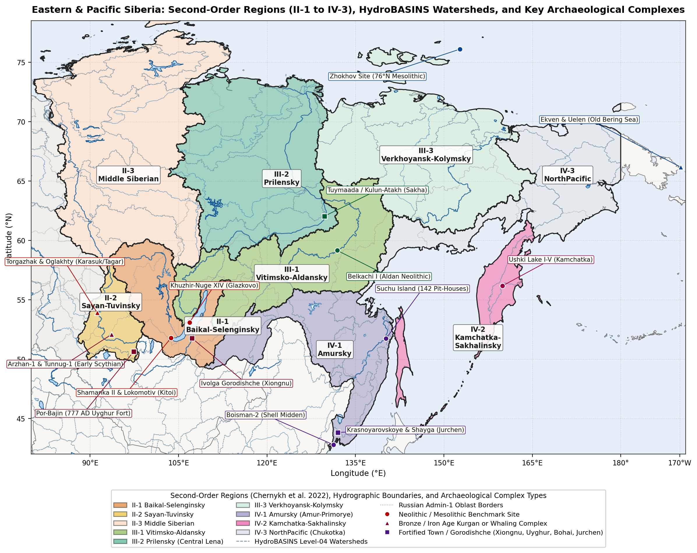
This paper reviews the archaeological, radiocarbon, stable-isotope, and historical demographic literature to estimate the population of Eastern and Pacific Siberia (~ 10,11M km²) from 10000BC to 1900AD. Following the regional drainage divisions established by Chernykh et al. [1], the study covers three major drainage systems and nine constituent regions (Figure 1): the Yenisei and Baikal Region (II-1 Baikal-Selenga, II-2 Sayan-Tuva, and II-3 Middle and Lower Yenisei), the Lena and Kolyma Region (III-1 Vitim-Aldan, III-2 Central Yakutia and Middle Lena, and III-3 Yana-Indigirka-Kolyma), and the Pacific Region (IV-1 Amur-Primorye, IV-2 Kamchatka-Sakhalin-Kurils, and IV-3 Chukotka-Anadyr). Rather than relying on global historical databases or treating raw radiocarbon date counts as direct measures of short-term population change, the estimates are derived from excavated house counts, cemetery burial cohorts, fortified settlement areas (gorodishcha), 17th-century Russian fur-tribute (yasak) registers [2], 18th- and 19th-century imperial poll-tax revisions (revizskie skazki), and the First All-Russian Imperial Census of 1897 [3][4][5]. Across all nine regions, the combined population grew from ~ 15,20k during the Younger Dryas (10000BC) to ~ 56,70k in the Middle Holocene (4500BC), ~ 201,30k during the Early Iron Age Tagar and Slab Grave period (500BC), and ~ 265,90k during the medieval Bohai, Uyghur, and Yenisei Kyrgyz period (800AD). In the mid-17th century (1650AD), Russian yasak records document 220,53k indigenous inhabitants (234,80k total population by 1700AD). Over the 18th and 19th centuries, natural growth among the Buryat and Sakha pastoralists and large-scale Russian peasant, Cossack, and mining settlement raised the total population to 390,80k in 1750AD, 669,00k in 1800AD, 1,17M in 1850AD, and 2,45M by 1900AD.
Background
Eastern and Pacific Siberia span a wide range of environments, from the sheltered steppes of the Minusinsk Hollow, Tuva, and the Selenga basin (II-1, II-2) and the temperate monsoon forests of the Amur, Ussuri, and Primorye plains (IV-1) to the thermokarst meadow-steppe depressions (alaas) of Central Yakutia (III-2), the continental permafrost larch taiga of the Tunguska, Vitim, Aldan, and Kolyma basins (II-3, III-1, III-3), and the salmon rivers and sea-mammal coasts of Kamchatka, Sakhalin, the Kurils, and the Bering Strait (IV-2, IV-3) [1]. Prior to the 17th century, crop cultivation was confined to the southern steppe valleys (II-1, II-2) and the Middle Amur, Ussuri, and Primorye lowlands (IV-1). Across the remaining 8,5M km² of boreal forest and Arctic tundra, population density depended on freshwater and anadromous fish runs, coastal sea-mammal hunting, wild ungulate hunting, and - from the medieval period onward - horse, cattle, and reindeer herding.
Four bodies of historical and archaeological research provide the empirical basis for the estimates presented here:
- Freshwater Reservoir-Corrected Radiocarbon Chronologies: In the Lake Baikal basin, the Baikal Hunter-Gatherer Project (BHGP) obtained over 538 accelerator mass spectrometry (AMS) radiocarbon dates paired with
and stable-isotope measurements from individual burials at Shamanka II, Lokomotiv, Ust'-Ida I, Kurma XI, and Khuzhir-Nuge XIV. Correcting for old carbon offsets of 300-700 years in fish and seal consumers confirmed a 700-year gap in formal cemetery burials (4900-4200 cal BC) between the Early Neolithic Kitoi culture and the Late Neolithic Isakovo-Serovo culture [6][7][8][9]. - Steppe Radiocarbon, Dietary, and Settlement Surveys: In the Minusinsk Hollow and Tuva (II-2), AMS dating and stable-isotope analyses of 354 individuals show that broomcorn millet (Panicum miliaceum) became a staple crop during the Karasuk (~ 1400-900 cal BC) and Tagar (~ 800-100 cal BC) periods, supporting a three- to fourfold increase in population reflected in tens of thousands of stone-walled burial mounds (kurgans) and permanent winter villages [10][11][12][13][14][15].
- Far Eastern Pit-House, Shell-Midden, and Fortified-Town Excavations: In the Amur-Primorye basin (IV-1) and the Northwest Pacific islands and coasts (IV-2, IV-3), excavations of Terminal Pleistocene pottery sites (Osipovka, Gromatukha), large Neolithic pit-house villages (Suchu Island with 142 house depressions; Boisman-2 shell midden), Bohai and Jurchen walled towns (Krasnoyarovskoye covering 180 ha; Shayginskoye with over 310 excavated heated dwellings), Kuril Island radiocarbon series (
dates), and Bering Strait whalebone villages (Ekven and Uelen with over 530 graves) provide direct house and burial counts [16][17][18][19][20][21][22][23][24][25]. - Russian Yasak Registers, Tax Revisions, and the 1897 Imperial Census: B. O. Dolgikh's clan-by-clan archival study of 17th-century yasak tax books [2], supplemented by regional archival studies of Khongorai (II-2), Yakutsk uyezd (III-2), Priamurye (IV-1), and Kamchatka-Chukotka (IV-2, IV-3) [26][27][28][29][30][31], establishes the mid-17th-century indigenous population. For the 18th and 19th centuries, the ten imperial poll-tax revisions (revizii of 1719-1858), the records of the 1763 Yasak Commission and post-1822 Steppe Dumas, guberniya statistical reviews, and the First All-Russian Imperial Census of 28 January 1897 document both indigenous demographic trends and the Russian agricultural and urban settlement of Eastern Siberia and the Far East [3][4][5][32][33][34][35].
Methodology
Regional Subdivisions
All population estimates are organised according to the nine second-order drainage regions defined by Chernykh et al. [1] and mapped in Figure 1 using HydroBASINS watersheds and Natural Earth physical and administrative boundaries:
- Yenisei and Baikal Region (II, ~ 3,28M km²): II-1 Baikal-Selenginsky (~ 650k km²: Lake Baikal, Upper Angara, Barguzin, Selenga, Uda, Khilok, Chikoy, and Onon-Ingoda headwaters), II-2 Sayan-Tuvinsky (~ 380k km²: Minusinsk Hollow, Abakan, Chulym, Kan, and Upper Yenisei / Ulug-Khem / Khemchik basins in Tuva), and II-3 Middle Siberian (~ 2,25M km²: Middle and Lower Yenisei, Lower Angara, Stony and Lower Tunguska, Pyasina, Khatanga, and Taimyr Peninsula).
- Lena and Kolyma Region (III, ~ 4,05M km²): III-1 Vitimsko-Aldansky (~ 1,12M km²: Vitim, Olekma, Aldan, Amga, Uchur, and Maya basins), III-2 Prilensky (~ 1,38M km²: Middle and Lower Lena, Central Yakutian alaas lowland, and Vilyuy basin), and III-3 Verkhoyansk-Kolymsky (~ 1,55M km²: Yana, Indigirka, Alazeya, Kolyma, and Omolon basins, plus the New Siberian Islands).
- Pacific Region (IV, ~ 2,78M km²): IV-1 Amursky (~ 980k km²: Shilka-Argun, Upper/Middle/Lower Amur, Zeya, Bureya, Ussuri, Lake Khanka, and Primorye coast), IV-2 Kamchatka-Sakhalinsky (~ 650k km²: Okhotsk coast, Kamchatka Peninsula, Sakhalin Island, and Kuril Archipelago), and IV-3 NorthPacific (~ 1,15M km²: Anadyr basin, Chukotka Peninsula, Bering Strait coast, and Koryak Highlands / Penzhina-Gizhiga bays).
Estimation Methods
Four standard archaeological and historical conversion methods are used to translate field and archival records into regional population totals across nineteen benchmark dates from 10000BC to 1900AD:
- Dwelling Floor Area and Household Size: Using standard floor-area ratios (~ 6-10 m² per person) and North Asian ethnographic observations [25][36], single-hearth pit-houses of 20-45 m² (Boisman, Yankovsky, and Shayga kan-heated houses) are estimated at 5-7 occupants; medium multi-hearth houses of 60-120 m² (Suchu Island, Okhotsk Culture, and Ekven whalebone nynglu) at 12-20 occupants; and large communal winter houses (Karasuk timber houses at Torgazhak of 100-200 m²; Itelmen winter zimniki of 150-300 m²) at 25-80 occupants.
- Fortified Settlement (Gorodishche) Density: For walled towns of the Xiongnu (Ivolga, Bayangol), Uyghur Khaganate (Por-Bajin, Shagonar), Bohai Kingdom (Kraskinskoye, Koksharovka-1), and Jurchen Jin / Eastern Xia (Krasnoyarovskoye, Shayginskoye), excavated dwelling counts (54 houses in 25% of the 7,2 ha interior at Ivolga; over 310 houses across 47,6 ha at Shayginskoye) indicate 30-55 dwellings/ha in residential wards, corresponding to 150-300 persons/ha in densely built towns and 40-80 persons/ha in large mountain refuge enclosures [21][22][37].
- Cemetery Burials to Living Community Size: Living community size
is estimated from the minimum number of individuals ( ) buried over a calibrated cemetery duration (in years) at an annual crude mortality rate via , where accounts for unexcavated cemetery area and subadult burial under-representation [8]. - Yasak Tribute Books, Poll-Tax Revisions, and the 1897 Census: Adult male tribute-payers (yasachnye lyudi, aged 18-50) in 17th-century Russian registers are converted to total population using B. O. Dolgikh's household multipliers [2]: x 3,5-4,0 for taiga and tundra hunter-herders (Evenks, Evens, Yukaghirs, Kets, Samoyeds), x 4,0-4,5 for pastoralists (Sakha, Buryats, Yenisei Kyrgyz, Tuvans), and x 4,5-5,0 for sedentary plough farmers and multi-family river fishers (Daurs, Duchers, Itelmens). For 1750, 1800, 1850, and 1900AD, district (uyezd / okrug) returns from the 2nd (1744), 5th (1795), and 9th-10th (1850-1858) revisions, Steppe Duma registers, and the 1897 Imperial Census (adjusted to 1900AD via guberniya statistical yearbooks) are allocated to the nine drainage regions [3][4][5][38].
Yenisei and Baikal Region
II-1 Baikal and Selenga Basin
Mesolithic, Early Neolithic Kitoi, and the Middle Holocene Gap (8000-1800 cal BC)
Following Terminal Pleistocene and Mesolithic hunting and fishing along the Angara rapids and Selenga river terraces (Ust'-Belaya, Studenoe-1/2, ~ 8000-5800 cal BC; regional population rising from ~ 2,2k at 10000BC to ~ 3,8k at 8000BC), the Early Neolithic Kitoi culture (Kitoyskaya kultura, reservoir-corrected to ~ 5750-4950 cal BC) established large formal cemeteries at productive fishing and sealing locations [6][7][8]:
- Shamanka II (Kultuk peninsula at the southwestern tip of Lake Baikal): Excavations uncovered 112 graves containing 155 individuals (116 AMS dates), with over 85% of burials belonging to the Kitoi phase (~ 5650-4950 cal BC) and a smaller Early Bronze Age Glazkovo component (13 individuals, ~ 2600-1950 cal BC) [8].
- Lokomotiv (Irkut-Angara confluence in Irkutsk): Excavations of 91 graves yielded an MNI of 149 individuals (~ 5750-5000 cal BC), whose elevated
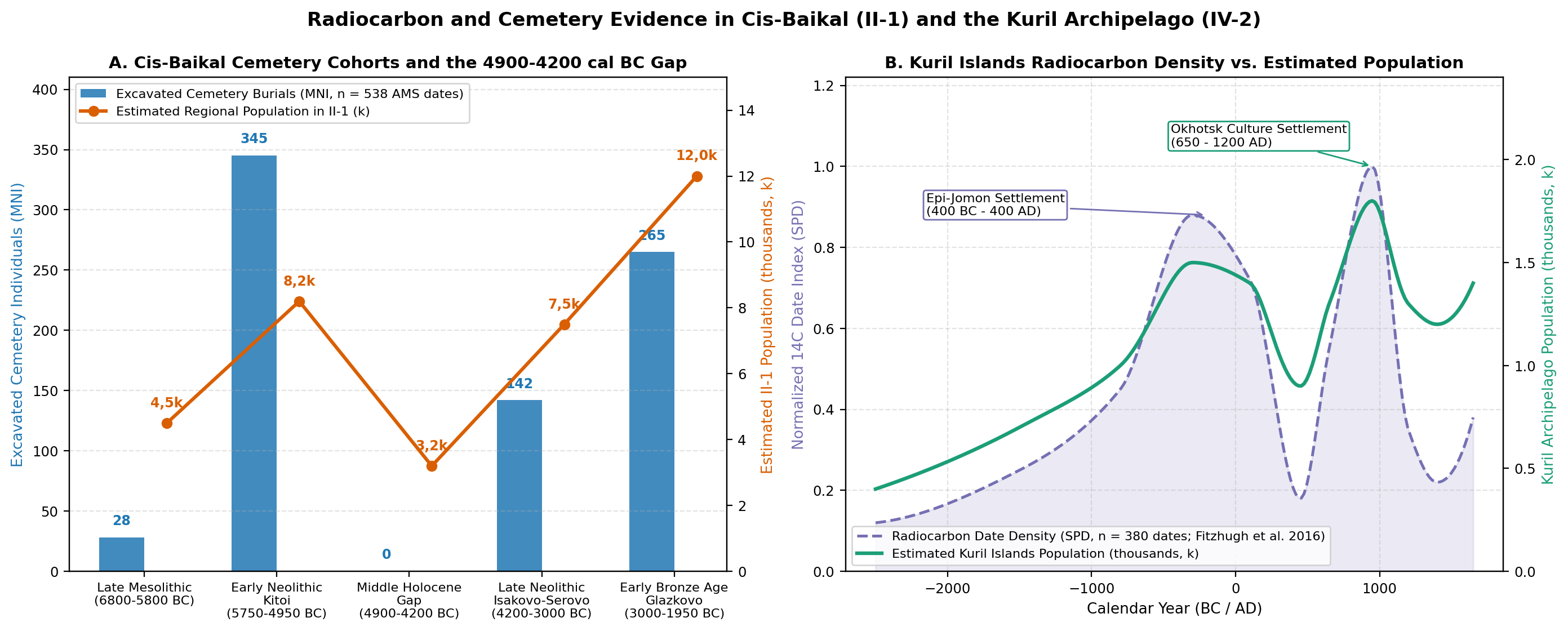
values (+13,5‰ to +16,8‰) reflect heavy reliance on Angara grayling, sturgeon, and Baikal seal (Pusa sibirica) [6][7]. - The Middle Holocene Cemetery Gap (~ 4900-4200 cal BC) and Late Neolithic / Glazkovo Recovery: Across all 538 reservoir-corrected AMS dates from Cis-Baikal cemeteries (Figure 3, Panel A), no formal cemetery burials date between 4900 and 4200 cal BC [7][9]. Large Kitoi fishing communities dispersed into smaller mobile hunting bands (regional population falling from ~ 8,2k at 6000BC to ~ 3,2k at 4500BC), before genetically distinct Late Neolithic Isakovo-Serovo (~ 4200-3000 cal BC; Ust'-Ida I with MNI = 67) and Early Bronze Age Glazkovo (~ 3000-1950 cal BC; Khuzhir-Nuge XIV with 79 graves and MNI = 89, Kurma XI, and Sagan-Zaba II sealing camps) communities raised the regional population to ~ 7,5k at 3000BC and ~ 12,0k at 2000BC [7][39].
Slab Grave, Khirigsuur, and the Xiongnu Northern Frontier (1300BC-100AD)
The spread of horse, sheep, goat, and cattle pastoralism during the Late Bronze and Early Iron Ages reshaped settlement across the Selenga, Uda, Khilok, Dzhida, and Onon-Ingoda steppes. More than 3,000 stone-slab burial enclosures of the Slab Grave culture (Kultura plitochnykh mogil, ~ 1300-300BC) and monumental khirigsuur stone mounds are recorded across Buryatia and western Transbaikalia, supporting an estimated regional population of ~ 18,5k by 1200BC and ~ 27,0k by 500BC.
From the late 2nd century BC to the 1st century AD, the Xiongnu Empire (Khunnu) incorporated the Selenga-Dzhida basin as a northern agricultural, ironworking, and garrison frontier [37][40]:
- Ivolga Fortress (Ivolginskoye gorodishche, 14 km southwest of Ulan-Ude): Enclosed by four concentric ramparts and ditches (348 x 216 m, ~ 7,2 ha preserved), A. V. Davydova's excavations of roughly a quarter of the interior exposed 54 semi-subterranean dwellings heated by L-shaped stone and clay flues (kan), iron-smelting furnaces, grain storage pits containing millet, barley, and wheat, and the adjacent 216-grave Ivolga cemetery. Scaling across the unexcavated quarters indicates ~ 300-380 contemporary houses, or a garrison and craft town of ~ 2,5k-3,0k residents [37].
- Bayangol (~ 10,0 ha), Dyrestui, Ilmovaya Pad (over 320 Xiongnu graves including aristocratic terraced tombs), and Nizhnemangirtuyskoe: Open agricultural and craft villages such as Nizhnemangirtuyskoe (1,8 ha) and Dureny I-II (extending along 12 km² of the Chikoy valley) supplied grain and iron tools to nomadic camps, supporting a regional population of ~ 36,0k around 1AD [40].
Medieval Kurykans, Buryat Steppe Dumas, and Russian Settlement (500-1900AD)
Between the 6th and 11th centuries AD, the Kurykan (Kurumchinskaya) confederation (the Gulifan of Tang Chinese chronicles, recorded as fielding up to 5,000 horsemen) built more than 40 stone-walled hillforts (shibe on Olkhon Island and in the Barguzin, Kuda, and Angara valleys), bloomery iron furnaces, and hay-meadow irrigation ditches, sustaining ~ 34,0k-35,5k people across II-1 between 800 and 1200AD. In the mid-17th century, B. O. Dolgikh [@Dolgikh1960, pp. 292-325] and V. N. Davydov et al. [41] reconstructed 27,3k Buryats (~ 13,5k western Bulagat, Ekhirit, and Khongodor Buryats along the Angara, Oka, and Olkhon, and ~ 13,8k eastern Khori, Selenga, and Tabunut Buryats) together with 9,3k Baikal and Daurian Evenks, giving an indigenous population of 36,60k in 1650AD (0,0563 persons/km²), rising to 49,0k by 1700AD after the founding of Irkutsk (1661), Selenginsk (1665), and Verkhneudinsk (1666).
During the 18th and 19th centuries, the Baikal-Selenga basin became the demographic core of Eastern Siberia [32][42]:
- Buryat Population Growth under the Steppe Dumas: Following the 1727 Treaty of Kyakhta (which fixed the Russo-Qing border and organised six Buryat border-guard regiments) and M. M. Speransky's 1822 Statute on Indigenous Administration (Ustav ob upravlenii inorodtsev, which created the Kudinskaya, Balaganskaya, Idinskaya, Verkholenskaya, Olkhonskaya, Tunkinskaya, and Alarskaya Steppe Dumas in Irkutsk Guberniya and the Khorinskaya, Selenginskaya, Barguzinskaya, and Aginskaya Steppe Dumas in Transbaikalia), Buryat households increasingly combined semi-sedentary livestock raising with haymaking and rye/wheat cultivation [32]. Archival returns compiled by P. I. Keppen, Yu. A. Gagemeister, and S. K. Patkanov show the Buryat population growing from ~ 27,3k in 1650 to ~ 73k at the 3rd Revision (1763), ~ 115k in 1800, ~ 195k at the 9th Revision (1850), and 288,6k in the 1897 Imperial Census (108,9k in Irkutsk Guberniya and 179,7k in Transbaikal Oblast) [4][42].
- Russian Peasant, Old Believer (Semeiskie), and Urban Expansion (1700-1900AD): From the 1760s, tens of thousands of exiled Old Believer peasants (Semeiskie) settled in the fertile Chikoy, Khilok, and Uda valleys of western Transbaikalia, while Russian peasant villages multiplied along the Moscow Highway (Moskovskiy trakt) toward Irkutsk (which grew to 51,5k inhabitants in 1897), Verkhneudinsk, Chita, and the tea-trade entrepôt of Kyakhta-Troitskosavsk [3][38]. Combined total population in II-1 rose from 105,0k in 1750AD to 210,0k in 1800AD, 415,0k in 1850AD, and 850,0k by 1900AD (~ 430k in the Upper Angara, Irkutsk, Balagansk, and Verkholensk districts of Cis-Baikal and ~ 420k in the Selenga, Barguzin, Verkhneudinsk, Troitskosavsk, Chita, and Aksha districts of western Transbaikalia).
II-2 Sayan, Minusinsk, and Tuva
Eneolithic to Late Bronze Age (Afanasievo, Okunev, Andronovo, Karasuk; 3100-800 cal BC)
After Upper Palaeolithic and Neolithic foraging along the Yenisei terraces (Afontova Gora, Kokorevo, Toora-Dash; regional population growing from ~ 2,5k at 10000BC to ~ 8,2k at 4500BC), the sheltered steppes of the Minusinsk Hollow and Tuva (II-2, ~ 380k km²) supported dense Bronze Age pastoral and farming populations [12][13]:
- Afanasievo (~ 3100-2500 cal BC), Okunev (~ 2500-1800 cal BC), and Andronovo/Fedorovo (~ 1800-1400 cal BC): Radiocarbon modelling of 88 new and over 300 previously published human-bone
dates [12] tracks the shift from early -diet herders ( ) to bronze-working pastoral communities (~ 14,0k at 3000BC and ~ 22,0k at 2000BC). - Karasuk Culture (Karasukskaya kultura, ~ 1400-900 cal BC): Human bone carbon isotope values shift sharply to
, demonstrating widespread cultivation of broomcorn millet alongside sheep and cattle transhumance [13]. More than 10,000 stone-slab burial enclosures (over 2,500 excavated across more than 100 cemeteries; Sukhaya Erba alone contains over 600 enclosures) and permanent winter villages such as Torgazhak on the Askiz River (6 excavated timber-and-sod pit-houses of 100-200 m² each, housing ~ 120-180 villagers) indicate a Late Bronze Age population of ~ 36,0k around 1200BC [10].
Early Iron Age Kurgans (Tagar, Aldy-Bel, Uyuk-Sagly) and Tashtyk Crypts (800BC-500AD)
- Tagar Culture in the Minusinsk Hollow (Tagarskaya kultura, ~ 800-100 cal BC): The Minusinsk basin contains the largest concentration of Early Iron Age burial mounds in Siberia, with 25,000-30,000 recorded kurgans across the Podgornovo, Saragash, and Tes stages, including the royal mound of Salbyk (70 x 70 m megalithic stone enclosure with slabs weighing 30-50 tonnes) and clan-marked enclosures below Mount Tepsei [11][43]. Collective timber burial vaults of the Saragash and Tes phases hold 30-150+ individuals per kurgan.
- Aldy-Bel and Uyuk-Sagly Cultures in Tuva (Arzhan-1, Tunnug-1, Arzhan-2): Satellite and geomagnetic surveys in the Uyuk River valley ("Siberian Valley of the Kings") have mapped thousands of stone and timber kurgans [14][15]. At Tunnug-1 (Arzhan-0, 9th century BC) and Arzhan-1 (~ 800 cal BC, 120 m diameter, 70 radial larch chambers containing over 160 sacrificed riding horses) [44], construction required an estimated 1,0k-1,5k workers. Combined Minusinsk (~ 36k) and Tuva (~ 22k) populations reached ~ 58,0k around 500BC.
- Tashtyk (Tashtykskaya kultura, 1st-7th centuries AD) and Kokel Cultures: Known for the permafrost burials at Oglakhty (painted plaster funerary masks and leather effigies) and collective burial crypts (sklepy) containing 20-120+ individuals [45], sustaining ~ 55,0k at 1AD and ~ 52,0k at 500AD.
Yenisei Kyrgyz, Uyghur Fortresses, Khongorai, and Imperial Settlement (600-1900AD)
- Uyghur Defensive Line in Tuva (745-840AD): Along the Khemchik and Ulug-Khem valleys, the Uyghur Khaganate built 17 rectangular stamped-clay (pakhs) fortresses connected by earthen ramparts (Dlinnaya Stena), including Shagonar I-V (Shagonar III covers 22 ha), Bazhyn-Alaak (18 ha), and the island complex of Por-Bajin (215 x 162 m, 3,5 ha in Lake Tere-Khol) [46][47]. Using the 774-775AD radiocarbon spike, Kuitems et al. [48] dated the felling of Por-Bajin's foundation larch timbers to the summer of 777AD under Tengri Bögü Khagan.
- Yenisei Kyrgyz State (6th-13th centuries AD): Supported by plough agriculture, irrigation canals (aryks) along the Abakan, Uybat, and Erba rivers, and elite chaatas cemeteries (Uybatsky, Kopensky), the Yenisei Kyrgyz overthrew the Uyghur Khaganate in 840AD [49]. Around 800-900AD, II-2 supported ~ 64,0k inhabitants (~ 40k in Minusinsk and ~ 24k in Tuva), before 13th-century Mongol campaigns (1207-1293AD) and deportations reduced the population to ~ 42,0k in 1200AD and ~ 28,0k in 1500AD.
- 17th-Century Khongorai and Tuva: In 1650AD, the four Yenisei Kyrgyz princely uluses (Altysar, Altyr, Isar, Tubin) and their tributary kyshtym clans (Kachin, Sagai, Beltir, Kyzyl, Shor, Kamasin) numbered ~ 12,8k, while Tuvans and Todzhins numbered ~ 11,2k and Sayan Samoyeds (Mator, Karagas, Koibal) ~ 1,2k, giving an indigenous population of 25,20k (0,0663 persons/km²) [2][26].
- 18th- and 19th-Century Peasant Colonisation of Minusinsk and Uriankhai (1700-1900AD): After the Qing Empire relocated a large part of the Yenisei Kyrgyz elite to the Ili valley in 1703 and Russia erected the Abakan (1707) and Sayansk (1718) forts, the Minusinsk, Achinsk, and Kansk forest-steppes became the premier grain-growing belt of Yeniseysk Guberniya (founded 1822) [34][50]. Under the Kachinskaya, Sagayskaya, and Kyzylskaya Steppe Dumas, the indigenous Khakas ("Yenisei Turks") grew from ~ 14k in the mid-18th century to 37,7k in the 1897 Census, while Russian peasant immigration pushed the total population of Minusinsk Okrug alone to 182,7k (with another 111,5k in Achinsk Okrug and 96,2k in Kansk Okrug) [3][34]. South of the Sayan Range in Qing-ruled Uriankhai (Tuva, Tangnu-Uryankhai), banners (khoshuns) of Tuvan pastoralists numbered ~ 50,0k-55,0k by the late 19th century, joined from the 1860s onward by Russian Old Believer farmers, gold miners, and merchants (~ 2,5k Russians by 1900AD) [51][52]. Across all of II-2, total population increased from 31,5k in 1700AD to 58,0k in 1750AD, 105,0k in 1800AD, 215,0k in 1850AD, and 440,0k in 1900AD.
II-3 Middle and Lower Yenisei
Covering ~ 2,25M km² of boreal taiga and Arctic tundra across the Middle and Lower Yenisei, Lower Angara, Stony and Lower Tunguska, and Taimyr Peninsula, II-3 was inhabited from the Early Holocene (Ust-Kova on the Lower Angara; Tagenar VI on the Taimyr Peninsula, ~ 6000 cal BC) by riverine fishers and wild reindeer hunters (rising from ~ 1,2k at 10000BC to ~ 4,8k at 4500BC and ~ 8,5k at 2000BC). During the 2nd millennium BC, Ymyyakhtakh and Pyasina groups operated the world's northernmost bronze foundries at Abylaakh-1 on the Kheta River (
In the 18th and 19th centuries, agricultural villages expanded along the Yeniseysk-Krasnoyarsk-Nizhneudinsk-Bratsk river and post-road corridors, while the discovery of rich alluvial gold in the North and South Yenisei taiga (the Yeniseysk gold rush of the 1830s-1850s) attracted tens of thousands of seasonal miners [3][50]. In the northern Turukhansk Krai (10,9k inhabitants in the 1897 Census), indigenous Evenk, Ket, Selkup, Enets, Nganasan, and Dolgan populations remained stable at ~ 10k-12k, while southern Kott, Arin, and Assan groups were linguistically assimilated into Russian and Khakas communities [4]. Overall population in II-3 rose from 48,0k in 1750AD to 78,0k in 1800AD, 132,0k in 1850AD, and 215,0k in 1900AD.
Lena and Kolyma Region
III-1 Vitim and Aldan Basins
Multi-layered river terrace sites along the Aldan, Olekma, and Vitim rivers (Belkachi I with 23 cultural horizons, Ust-Timpton with 26 horizons, Sumnagin I with 38 horizons, and Ust-Mil II) provide the primary radiocarbon sequence for interior Northeast Asia [54]:
- Terminal Pleistocene Dyuktai (~ 14000-8500 cal BC) and Early Holocene Sumnagin Mesolithic (Sumnaginskaya kultura, ~ 8500-5000 cal BC, 46
dates): Non-ceramic microblade hunters occupying light surface chum tents (3-4 m stone-ring hearths) hunted elk (Alces alces) and wild reindeer along the Aldan and Vitim valleys (regional population growing from ~ 1,0k at 10000BC to ~ 1,8k at 8000BC and ~ 2,8k at 6000BC). - Syalakh (~ 5000-3800 cal BC, 34 dates), Belkachi (~ 3800-2200 cal BC, 42 dates), and Ymyyakhtakh (~ 2200-1000 cal BC, 90 dates) Cultures: Net-impressed, cord-marked, and waffle-stamped pottery accompanied semi-subterranean winter houses and composite bone/antler bows (Belkachi I, Tuoi-Khaya), raising the regional population from ~ 4,0k at 4500BC to ~ 6,5k at 2000BC [54][55].
- Bronze Age Ust-Mil Culture (~ 1300-400 cal BC, 48 dates), Iron Age, and 17th-19th Century Settlement: Local bronze casting (Ust-Mil II) and Early Iron Age ironworking supported ~ 7,4k people at 1200BC and ~ 9,6k at 1200AD. In 1650AD [@Dolgikh1960, pp. 440-510], III-1 held ~ 8,8k Evenks and ~ 1,5k southern Evens (10,30k total; 0,0092 persons/km²). In the 18th and early 19th centuries, Sakha cattle-and-horse pastoralists settled along the Amga and lower Aldan valleys, raising the regional population to 13,5k in 1750AD and 18,0k in 1800AD. From the 1840s to 1890s, the opening of the Olekma and Vitim (Bodaibo) placer goldfields drew thousands of Russian, Sakha, and Buryat mineworkers and carters, lifting III-1 from 26,0k in 1850AD to 48,0k in 1900AD [3][33].
III-2 Central Yakutia and Middle Lena
Throughout the Neolithic, Bronze Age, and Early Iron Age (Syalakh, Belkachi, Ymyyakhtakh, Ust-Mil, Kullaty, Pokrovsk), the Middle Lena, Lower Lena (Siktyakh, Zhigansk), and Vilyuy river basins were occupied by taiga hunting and fishing bands whose population grew gradually from ~ 1,1k at 10000BC to ~ 4,6k at 4500BC, ~ 7,5k at 2000BC, and ~ 9,6k at 1AD [54].
Between the 11th and 14th centuries AD, Turkic-speaking Sakha (Yakuty) ancestors migrating from the Baikal-Angara region introduced hardy northern horse and cattle breeding into the Central Yakutian Lowland (the Tuymaada, Erkeeni, and Ensieli valleys along the Middle Lena and the Lena-Amga interfluve between
- Kulun-Atakh Culture (Kulun-Atakhskaya kultura, 14th-16th centuries AD): Excavations at Kulun-Atakh, Ugar, Sayylyk, and the 15th-century site of Ayyy-Taybyt in Yakutsk uncovered timber winter houses (balagan) with clay-plastered hearths (komulok), birch-bark summer tents (urasa), bloomery iron furnaces, and hay-storage corrals [36]. Contemporaneous "Small Houses" (Kultura malykh domov) sites around the edges of the alaas lowland represent neighbouring Evenk hunter-fishers adopting Sakha material culture and language [36].
- 17th-Century Yakutsk Uyezd Yasak Registers (35 Volosts): When Russian Cossacks founded Yakutsk Ostrog in 1632, over 80% of the Sakha lived within a 25,000 km² alaas core between the Middle Lena, lower Aldan, and lower Amga (local density > 1,1 persons/km²). From the yasak books of 1634-1690, B. O. Dolgikh [@Dolgikh1960, pp. 346-439] and V. V. Ushnitskiy [27][28] reconstructed 28,47k Sakha across 35 volosts (Kangalasskaya ~ 4,8k, Meginskaya ~ 3,6k, Borogonskaya ~ 3,3k, Baturusskaya ~ 3,1k, Namskaya ~ 2,5k, Betunskaya ~ 1,6k, and Bayagantayskaya, plus Vilyuy and Olekma settlements established from the 1630s onward) alongside ~ 5,7k Vilyuy and Lower Lena Evenks, yielding an indigenous population of 34,17k in 1650AD (37,5k in 1700AD including Russian servicemen and Lena peasant farmers).
- 18th- and 19th-Century Sakha Expansion and the 1897 Census (1700-1900AD): Despite periodic smallpox outbreaks in the 18th century, the Sakha expanded steadily across the entire Vilyuy basin (Suntar, Nyurba, Verkhnevilyuysk) and the Olekma valley, draining thermokarst lakes (khoruu) to create new hay meadows and adopting barley and rye farming from Russian peasants settled along the Lena post stations [27][33]. Poll-tax revisions and Yakut Steppe Duma records show the Sakha growing from ~ 28,5k in 1650 to ~ 80k at the 3rd Revision (1763), ~ 125k at the 7th Revision (1816), ~ 185k at the 10th Revision (1858), and 225,8k across Yakutsk Oblast in the 1897 Imperial Census (83,7% of the oblast's 269,9k residents, with Russians accounting for ~ 30k and Evenks/Evens/Yukaghirs ~ 14k) [4][33][58]. Within the bounds of III-2 (Yakutsk, Vilyuysk, and Olekminsk okrugs), total population increased from 62,0k in 1750AD to 112,0k in 1800AD, 175,0k in 1850AD, and 225,0k in 1900AD.
III-3 Yana, Indigirka, and Kolyma Basins
- Zhokhov Site (
, De Long Archipelago, ~ 7000-5800 cal BC): Excavations by V. V. Pitulko (over 540 m² of permafrost trench and more than 70 dates) uncovered 13 semi-subterranean driftwood and whalebone dwellings at , intensive polar bear (Ursus maritimus, MNI > 150) and reindeer (MNI > 200) hunting, engineered wooden dog sleds, and obsidian blades transported over 1,500 km from Lake Krasnoye on the lower Anadyr, representing a resident hunting band of ~ 25-50 people [55]. - Continental Kolyma and Indigirka Sequence (Burkhala, Rodinka, Labuya): Along the Upper and Lower Kolyma and Indigirka, S. B. Slobodin [59][60] documented Mesolithic and Neolithic campsites (Burkhala yielded over 6,000 stone artefacts around stone-lined hearths; the Rodinka II burial contained 36 bone/antler arrowheads and 130 adzes and knives), consistent with a gradual rise in population from ~ 0,7k at 10000BC to ~ 3,8k at 2000BC and ~ 4,9k at 1AD.
- 17th- to 19th-Century Yukaghir, Even, and Northern Sakha Demographics (1650-1900AD): For 1650AD, B. O. Dolgikh [@Dolgikh1960, pp. 380-438] reconstructed 3,29k Yukaghirs within III-3 (~ 775 Yana Yukaghirs, ~ 1,20k Indigirka and Alazeya Yukaghirs, and ~ 1,32k Kolyma and Omolon Yukaghirs, out of 4,78k total Yukaghirs including 1,49k Anadyr Chuvans, Khodyntsy, and Anauls in IV-3), ~ 2,40k Verkhoyansk-Kolyma Evens (Lamuty), and ~ 0,30k northern Sakha, giving 5,99k indigenous inhabitants (0,0039 persons/km²). Over the 18th and 19th centuries, smallpox epidemics and linguistic assimilation reduced the registered Yukaghirs to fewer than 1,0k by 1897, while northern Sakha cattle-and-horse herders and Even reindeer herders expanded across the Yana, Indigirka, and Kolyma valleys [4][33]. In the 1897 Imperial Census, Verkhoyansk Okrug recorded 14,3k inhabitants and Kolymsk Okrug 7,9k inhabitants, bringing III-3 from 6,3k in 1700AD to 8,0k in 1750AD, 11,5k in 1800AD, 16,5k in 1850AD, and 22,2k in 1900AD [3][58].
Pacific Region
IV-1 Amur, Ussuri, and Primorye
Early Pottery, Pit-House Villages, and Millet Farming (10000-1000 cal BC)
- Osipovka (Gasya, Khummi, Goncharka-1) and Gromatukha Cultures: The Lower and Middle Amur preserve some of the oldest pottery vessels in the world (13,300-12,300 uncal BP / ~ 14200-12200 cal BC), used by riverine fishers harvesting seasonal runs of chum and pink salmon [16][17][61].
- Neolithic Pit-House Villages (Suchu Island, Kondon, Boisman-2): During the Mariinskoe, Malyshevo, Kondon, and Voznesenovka phases (~ 6000-1500 cal BC), large permanent fishing villages lined the Lower Amur [19]. On Suchu Island (3,7 ha), more than 142 circular and oval semi-subterranean house depressions (over 25 excavated, 35-150 m² floor area) housed ~ 120-250 residents at a time. Along Peter the Great Gulf in southern Primorye, the Boisman culture (Boisman-1 and 2, ~ 4800-3000 cal BC) left oyster shell middens with ring cemeteries (over 40 skeletons at Boisman-2,
) [18][62]. - Zaisanovka Millet Cultivation (~ 3000-1300 cal BC): Direct AMS dates on charred foxtail and broomcorn millet (Setaria italica, Panicum miliaceum) at Krounovka-1, Novoselishche-4, and Bogolyubovka-1 (over 25 excavated pit-houses) date the introduction of dryland farming in Primorye to ~ 2900-2500 cal BC, supporting a rise in regional population from ~ 17,5k at 4500BC to ~ 25,5k at 3000BC and ~ 34,0k at 2000BC [16][63].
Iron Age Villages, the Bohai Kingdom (698-926AD), and Jurchen Fortresses (1115-1234AD)
- Early Iron Age (~ 1000BC-400AD) and Mohe (4th-10th centuries AD): Coastal Yankovsky shell-midden farming villages (Peschany-1 with over 30 houses), inland Krounovka settlements with heated kan flues, and Middle Amur Urily and Poltse villages (Poltse I contained 10 large burned houses, each holding 50-100 ceramic storage jars) raised the population of IV-1 to ~ 55,0k at 500BC, ~ 66,0k at 1AD, and ~ 72,0k at 500AD (the Troitskoye Mohe cemetery on the Middle Amur yielded over 218 graves).
- Bohai Kingdom (Gosudarstvo Bokhay, 698-926AD): More than 20 walled Bohai towns and over 200 rural villages have been mapped in Primorye [20][64], including the stone-walled port city of Kraskinskoye (~ 13,0 ha, 1,380 m perimeter wall, Buddhist temple, roof-tile kilns, and residential wards housing ~ 1,5k-3,0k inhabitants), Koksharovka-1 (16 ha), and Maryanovka (15 ha), supporting ~ 86,0k people across IV-1 around 800AD.
- Jurchen Jin Empire (1115-1234AD) and the Eastern Xia State (1215-1233AD): Over 30 Jurchen mountain fortresses (gorodishcha) and valley towns were built across Primorye [21][22]:
- Krasnoyarovskoye Gorodishche (near Ussuriysk, ~ 180 ha enclosed by an 8 km stone-and-earth rampart): Puxian Wannu's northern capital of Kaiyuan, containing a walled inner palace compound and terraced residential quarters (wartime urban population of ~ 10,0k-20,0k) [22].
- Shayginskoye Gorodishche (47,6 ha): Excavations uncovered more than 310 dwellings heated by kan flues, 14 ironworking and bronze workshops, and an inner citadel, supporting ~ 3,0k-4,5k permanent inhabitants (~ 550 total houses) [21].
- Ananyevskoye (31 ha), Nikolaevskoye (27 ha), Yekaterinovskoye (27 ha), Skalistoye (22 ha), and Lazovskoye (19 ha) each held 1,5k-3,5k residents, bringing IV-1 to a medieval peak of ~ 95,0k around 1200AD, before the Mongol conquest of 1233AD and subsequent Ming and early Qing resettlements reduced the population to ~ 54,0k by 1500AD.
17th-Century Qing Deportations, Nerchinsk Mining, and Post-1858 Far Eastern Settlement (1640-1900AD)
When Vasily Poyarkov (1643-1646) and Yerofey Khabarov (1649-1653) descended the Amur, they encountered fortified timber towns (Albazin, Guigudar with ~ 1,000 residents, Tolga, Atchansky) inhabited by plough-farming Daurs (~ 9,7k along the Upper/Middle Amur and Zeya) and Duchers (~ 14,0k along the Middle Amur), alongside ~ 9,0k Amur Evenks and Negidals, ~ 7,5k Nanai (5,2k) and Ulchi (2,3k), ~ 4,3k mainland Nivkhs, and ~ 2,4k Udege and Orochi, giving an indigenous total of 46,90k in 1650AD (0,0479 persons/km²) [2][29][30]. Between 1654 and 1658, the Qing government forcibly evacuated ~ 20k-24k Daurs and Duchers southward to the Nonni and Sungari valleys in Manchuria to deprive Russian Cossacks of local grain supplies, reducing the population of IV-1 to 28,5k by 1700AD [5][30].
Between 1689 (Treaty of Nerchinsk) and 1858, Russian territory within the Amur drainage was limited to the upper Shilka and Argun valleys of eastern Transbaikalia (Nerchinsk Mining District, founded 1704), where silver-lead mines, metallurgical works, and peasant villages grew the regional population of IV-1 to 62,0k in 1750AD, 102,0k in 1800AD, and 155,0k in 1850AD (while the Middle/Lower Amur and Ussuri basins held only ~ 17,7k indigenous Nanai, Ulchi, Nivkh, Evenk, Udege, and Manchu-Chinese residents in 1858) [5]. Following the 1858 Treaty of Aigun and 1860 Treaty of Beijing, large-scale settlement transformed Priamurye and Primorye [5][65][66]:
- Cossack, Peasant, and Maritime Colonisation (1858-1900AD): The Russian government established the Amur and Ussuri Cossack Hosts along the border rivers and, after launching regular steamship voyages of the Volunteer Fleet (Dobroflot) from Odessa to Vladivostok in 1883 and beginning construction of the Ussuri and Trans-Siberian Railways in 1891, settled over 150,000 Ukrainian and Russian peasants in the Zeya-Bureya plain and Khanka-Ussuri lowland [5][66]. Rapidly growing cities included Vladivostok (28,9k in 1897), Blagoveshchensk (32,8k), Khabarovsk (15,0k), and Nikolsk-Ussuriysky (10,9k), alongside Korean farming villages (~ 26k Koreans in 1897) and Chinese merchants and gold miners (~ 57k Chinese in 1897) [3][65].
- 1897 Imperial Census and 1900AD Totals: By 1897-1900AD, Amur Oblast counted 120,3k inhabitants in 1897 (130,4k in 1900), the southern districts of Primorskaya Oblast (South Ussuri, Khabarovsk, and Udsk/Nikolaevsk okrugs) counted ~ 207k in 1897 (~ 245k in 1900), and the Nerchinsk / Shilka-Argun okrugs of eastern Transbaikalia counted ~ 215k, giving IV-1 a total population of 590,0k in 1900AD [3][5].
IV-2 Kamchatka, Sakhalin, and the Kuril Islands
- Kamchatka (Ushki Lake, Tarya, and Old Itelmen Fortified Settlements): At Ushki I and V in the central Kamchatka River valley, Goebel, Waters, and Dikova [67] dated Layer VII (over 10 double-chambered surface dwellings, stemmed points, and a dog burial) to ~ 11000-10700 cal BC and Layer VI (over 40 semi-subterranean pit-houses with stone-lined entrance tunnels and microblades) to ~ 10300-9800 cal BC. During the Late Holocene (Tarya and Old Itelmen phases), more than 120 fortified riverine settlements (ostrozhki) lined the Kamchatka, Bolshaya, Avacha, and Tigil rivers, each housing 50-100+ people in communal winter zimniki and raised summer balagans. For 1650AD, Dolgikh [@Dolgikh1960, pp. 562-578], Zuev [68], and Tolkacheva [31] reconstructed 12,68k Itelmens (Kamchadaly), ~ 3,50k northern Kamchatka and Karaga Koryaks, and ~ 2,90k Okhotsk-coast Evens.
- Sakhalin Island (160
Dates from 74 Sites) and the Kuril Archipelago ( Dates): On Sakhalin, Kuzmin, Vasilevski et al. [69] documented continuous occupation from Early Neolithic blade sites (~ 7000 cal BC) and Middle/Late Neolithic Imchin pit-house villages to the Susuya (~ 500BC-400AD) and Okhotsk (~ 400-1200AD) maritime sea-mammal hunting cultures (~ 2,0k Sakhalin Nivkhs, ~ 2,8k Sakhalin Ainu, and ~ 0,4k Uilta/Evenks in 1650AD). Across the Kuril Islands, Fitzhugh et al. [23] identified two major maritime settlement episodes (Epi-Jomon at ~ 400BC-400AD and Okhotsk Culture at ~ 650-1200AD, followed by Kuril Ainu communities of ~ 1,4k residents; Figure 3, Panel B). Across all of IV-2, population rose from ~ 1,8k at 10000BC to ~ 13,5k at 2000BC, ~ 20,0k at 1AD, ~ 24,0k at 800AD, and 25,68k in 1650AD (0,0395 persons/km²). - 18th-Century Epidemics, Sakhalin Penal Colonisation, and the 1897 Census (1700-1900AD): Following Russian conquest in 1697-1706, heavy transport requisitions, armed uprisings (1706, 1731, 1746), and the devastating smallpox epidemic of 1768-1769 (which killed roughly two-thirds of the Itelmens) reduced the population of IV-2 from 26,2k in 1700AD to 18,5k in 1750AD and 16,0k in 1800AD [31][68]. In the second half of the 19th century, after the 1875 Treaty of Saint Petersburg recognised Russian sovereignty over all of Sakhalin in exchange for ceding the Kuril Islands to Japan, the imperial government expanded the Sakhalin penal colony (katorga). In the 1897 Census, Sakhalin Island recorded 28,1k inhabitants (20,4k males and 7,7k females, including ~ 4,3k indigenous Nivkhs, Ainu, and Uilta alongside Russian convicts, exiles, and guards), while Petropavlovsk (Kamchatka) Okrug counted 8,4k, Okhotsk Okrug 4,7k, the Commander Islands 0,65k, and the Kuril Islands ~ 4,1k, bringing IV-2 to 46,0k in 1900AD [3][5].
IV-3 Chukotka, Anadyr, and the Bering Strait
While interior Chukotka and the Anadyr basin were occupied by wild-reindeer hunters at river crossings (Ust-Belaya, Chirovoe, ~ 3000-500 cal BC), the Bering Strait headlands (Uelen, Ekven, Sireniki, Chini, Enmynytnyn) supported dense maritime sea-mammal and bowhead whaling communities of the Old Bering Sea (~ 200BC-800AD), Birnirk (~ 500-1000AD), Punuk (~ 700-1400AD), and Thule (~ 1000-1700AD) cultures [24][25][70]. Excavations at Ekven (over 330 graves, MNI > 350) and Uelen (over 200 graves) and reconstructions of semi-subterranean bowhead-whalebone and driftwood winter dwellings (nynglu, housing 15-30 occupants each) indicate coastal villages of 150-400 residents [24][25]. Between ~ 1300 and 1650AD, interior Chukchi (Chauchu) and Chavchuven Koryaks developed large-herd tundra reindeer pastoralism. In 1650AD [@Dolgikh1960, pp. 547-561; @Turaev2013], IV-3 held 7,25k mainland Koryaks (settled coastal Nymylan and nomadic Chavchuven), 4,00k Siberian Yupik, 2,50k Chukchi, and 1,49k Anadyr Yukaghirs (Chuvans, Khodyntsy, Anauls), totalling 15,24k indigenous inhabitants (0,0133 persons/km²).
During the 18th and 19th centuries, following the withdrawal of the Anadyr garrison in 1764 and the opening of peaceful trade at the Anyuy Fair (1788), tundra reindeer-herding Chukchi expanded their pastures westward toward the Kolyma and southward into Koryak lands, growing from ~ 2,5k in the mid-17th century to ~ 11,8k by 1897 [35]. In the 1897 Imperial Census (conducted in Anadyr and Chukotka with the participation of exiled ethnographer V. G. Bogoraz), Anadyr Okrug (12,1k) and the northern mainland portion of Gizhiga Okrug (7,5k total) recorded ~ 18,0k inhabitants across IV-3 (~ 11,8k Chukchi, ~ 3,8k mainland Koryaks, ~ 1,3k Siberian Yupik, ~ 0,6k Chuvans and Yukaghirs, and ~ 0,5k Russians), reflecting gradual growth from 15,5k in 1700AD to 15,8k in 1750AD, 16,5k in 1800AD, 17,2k in 1850AD, and 18,0k in 1900AD [4][35].
Population Estimates
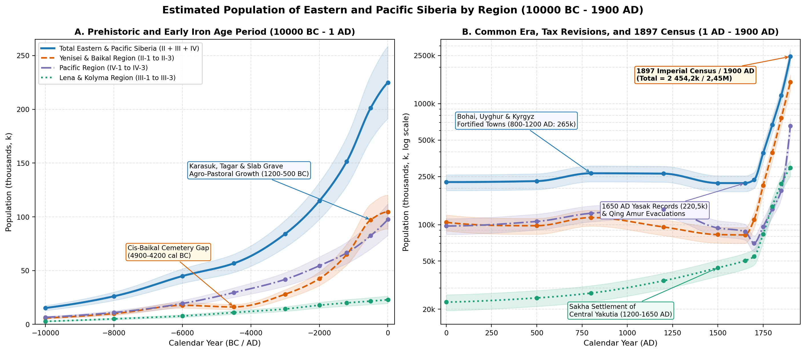
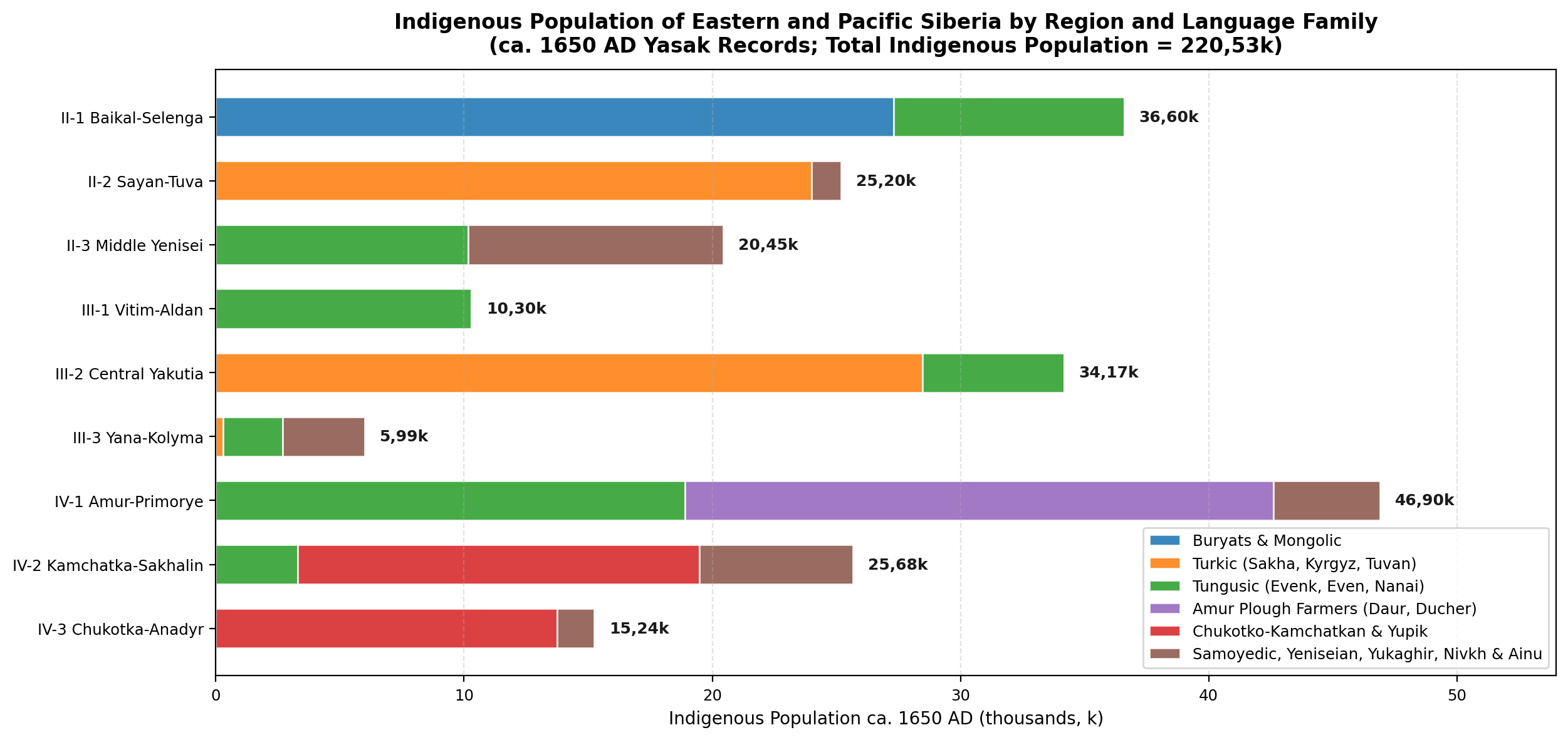
Figures 2, 3, and 4 and Tables 1, 2, 3, and 4 summarise the archaeological, yasak, tax-revision, and 1897 Census population estimates across all nine regions from 10000BC to 1900AD.
| Site / Complex | Reg. | Culture & Calibrated Date | Area & Excavated Features | Site Population |
|---|---|---|---|---|
| Shamanka II (SW Baikal) | II-1 | Early Neolithic Kitoi (5650-4950BC) | 112 graves, MNI = 155 (116 AMS dates) | 35-60 band |
| Lokomotiv (Angara) | II-1 | Early Neolithic Kitoi (5750-5000BC) | 91 graves, MNI = 149 (FRE-corrected) | 50-80 band |
| Khuzhir-Nuge XIV (Baikal) | II-1 | Early Bronze Glazkovo (2750-1950BC) | 79 slab graves, MNI = 89 (82 AMS dates) | 30-50 band |
| Ivolga Gorodishche | II-1 | Xiongnu Frontier (150BC-50AD) | 7,2 ha (4 ramparts); 54 kan houses, 216 graves | 2,5k-3,0k town |
| Torgazhak (Minusinsk) | II-2 | Late Bronze Karasuk (1100-900BC) | 1,5 ha village; 6 timber houses (100-200 m2) | 120-180 village |
| Arzhan-1 & Tunnug-1 | II-2 | Early Scythian Aldy-Bel (9th-8th c. BC) | 110-120 m royal kurgans; 70 chambers, 160+ horses | 1,0k-1,5k builders |
| Oglakhty Cemetery | II-2 | Tashtyk Culture (1st-7th c. AD) | Permafrost graves + collective crypts (20-100+ MNI) | 150-300 clan |
| Por-Bajin & 17 Forts | II-2 | Uyghur Khaganate (Summer 777AD) | 3,5 ha palace (Por-Bajin); 22 ha (Shagonar III) | 8,0k-15,0k line |
| Ayyy-Taybyt & Sayylyk | III-2 | Sakha Kulun-Atakh (14th-16th c. AD) | Alaas timber balagan dwellings & cattle corrals | 15-40 homestead |
| Zhokhov Site (76 N) | III-3 | Arctic Mesolithic (7000-5800BC) | 13 driftwood/whalebone houses (>540 m2 trench) | 25-50 band |
| Suchu Island (Amur) | IV-1 | Neolithic Villages (6000-1500BC) | 3,7 ha island; 142 pit-houses (25+ excavated) | 120-250 village |
| Boisman-2 (Primorye) | IV-1 | Middle Neolithic (4400-3300BC) | Shell midden; 5 houses + 28 graves (MNI > 40) | 35-60 band |
| Kraskinskoye (Posyet) | IV-1 | Bohai Port City (8th-10th c. AD) | 13,0 ha walled city (1 380 m perimeter), temple | 1,5k-3,0k city |
| Krasnoyarovskoye | IV-1 | Jurchen Capital Kaiyuan (1215-1233AD) | 180,0 ha mountain capital (8 km wall), Forbidden City | 10,0k-20,0k city |
| Shayginskoye | IV-1 | Jurchen Fortress Town (1215-1233AD) | 47,6 ha fortress; >310 kan houses, 14 workshops | 3,0k-4,5k town |
| Ushki Lake I & V | IV-2 | Terminal Pleistocene (11000-9800BC) | Layers VII-VI: >50 surface & pit dwellings | 30-60 band |
| Ekven & Uelen | IV-3 | Old Bering Sea / Punuk (200BC-1400AD) | >530 graves (Ekven >330, Uelen >200) + nynglu houses | 150-400 village |
| Region | Area (km2) | 1650 Indig. | 1900 Total | Ethno-Demographic Composition (1650AD vs. 1897/1900AD) |
|---|---|---|---|---|
| II-1 Baikal-Selenginsky | 650 000 | 36,60k | 850,0k | 1650: Buryats 27,3k, Evenks 9,3k. 1897/1900: Buryats 288,6k, Russians & Semeiskie ~548k, Evenks ~13k |
| II-2 Sayan-Tuvinsky | 380 000 | 25,20k | 440,0k | 1650: Kyrgyz/Khakas 12,8k, Tuvans 11,2k. 1897/1900: Minusinsk-Achinsk-Kansk Russians ~345k, Khakas 37,7k, Tuva ~55k |
| II-3 Middle Siberian | 2 250 000 | 20,45k | 215,0k | 1650: Evenks 10,16k, Kets/Yeniseians 5,54k, Samoyeds 4,75k. 1897/1900: Yeniseysk/Angara Russians ~192k, Indig. ~23k |
| Subtotal Yenisei & Baikal (II) | 3 280 000 | 82,25k | 1 505,0k | Yenisei & Baikal Region (82,25k indigenous in 1650AD; 1 505,0k total by 1900AD) |
| III-1 Vitimsko-Aldansky | 1 120 000 | 10,30k | 48,0k | 1650: Evenks 8,8k, Evens 1,5k. 1897/1900: Vitim-Olekma goldfields ~22k, Amga-Aldan Sakha ~14k, Evenks/Evens ~12k |
| III-2 Prilensky | 1 380 000 | 34,17k | 225,0k | 1650: Sakha 28,47k (35 volosts), Evenks 5,7k. 1897/1900: Sakha ~198k in III-2 (225,8k in oblast), Russians ~20k |
| III-3 Verkhoyansk-Kolymsky | 1 550 000 | 5,99k | 22,2k | 1650: Yukaghirs 3,29k, Evens 2,4k, Sakha 0,3k. 1897/1900: Verkhoyansk & Kolymsk okrugs (Sakha, Evens, Yukaghirs, Russians) |
| Subtotal Lena & Kolyma (III) | 4 050 000 | 50,46k | 295,2k | Lena & Kolyma Region (50,46k indigenous in 1650AD; 295,2k total by 1900AD) |
| IV-1 Amursky | 980 000 | 46,90k | 590,0k | 1650: Duchers 14,0k, Daurs 9,7k, Evenks/Nanai/Nivkh 23,2k. 1900: Amur (130k), S. Primorye (245k), Nerchinsk (215k) |
| IV-2 Kamchatka-Sakhalinsky | 650 000 | 25,68k | 46,0k | 1650: Itelmens 12,68k, Koryaks 3,5k, Ainu 4,2k, Evens/Nivkh 5,3k. 1897/1900: Sakhalin (28,1k), Kamchatka-Okhotsk-Kurils (17,9k) |
| IV-3 NorthPacific | 1 150 000 | 15,24k | 18,0k | 1650: Koryaks 7,25k, Yupik 4,0k, Chukchi 2,5k, Chuvans 1,49k. 1897/1900: Chukchi 11,8k, Koryaks 3,8k, Yupik 1,3k |
| Subtotal Pacific Region (IV) | 2 780 000 | 87,82k | 654,0k | Pacific Region (87,82k indigenous in 1650AD; 654,0k total by 1900AD) |
| TOTAL (II + III + IV) | 10 110 000 | 220,53k | 2 454,2k | Complete Eastern & Pacific Siberia (220,53k indigenous in 1650AD; 2 454,20k / 2,45M total in 1900AD) |
| Benchmark | II-1 | II-2 | II-3 | III-1 | III-2 | III-3 | IV-1 | IV-2 | IV-3 | Total |
|---|---|---|---|---|---|---|---|---|---|---|
| 10000BC | 2,2k | 2,5k | 1,2k | 1,0k | 1,1k | 0,7k | 3,5k | 1,8k | 1,2k | 15,20k |
| 8000BC | 3,8k | 4,0k | 2,2k | 1,8k | 2,0k | 1,3k | 6,0k | 3,0k | 2,0k | 26,10k |
| 6000BC | 8,2k | 6,0k | 3,5k | 2,8k | 3,2k | 1,8k | 11,0k | 5,2k | 3,2k | 44,90k |
| 4500BC | 3,2k | 8,2k | 4,8k | 4,0k | 4,6k | 2,4k | 17,5k | 7,5k | 4,5k | 56,70k |
| 3000BC | 7,5k | 14,0k | 6,5k | 5,2k | 6,0k | 3,1k | 25,5k | 10,5k | 5,8k | 84,10k |
| 2000BC | 12,0k | 22,0k | 8,5k | 6,5k | 7,5k | 3,8k | 34,0k | 13,5k | 7,0k | 114,80k |
| 1200BC | 18,5k | 36,0k | 10,5k | 7,4k | 8,4k | 4,2k | 43,0k | 15,5k | 8,0k | 151,50k |
| 500BC | 27,0k | 58,0k | 12,2k | 8,0k | 9,0k | 4,6k | 55,0k | 18,0k | 9,5k | 201,30k |
| 1AD | 36,0k | 55,0k | 13,5k | 8,4k | 9,6k | 4,9k | 66,0k | 20,0k | 11,5k | 224,90k |
| 500AD | 31,0k | 52,0k | 15,0k | 8,8k | 10,8k | 5,2k | 72,0k | 21,5k | 12,8k | 229,10k |
| 800AD | 34,0k | 64,0k | 16,5k | 9,2k | 12,5k | 5,5k | 86,0k | 24,0k | 14,2k | 265,90k |
| 1200AD | 35,5k | 42,0k | 18,2k | 9,6k | 19,0k | 5,8k | 95,0k | 24,5k | 14,5k | 264,10k |
| 1500AD | 35,0k | 28,0k | 19,8k | 10,0k | 28,0k | 6,0k | 54,0k | 25,0k | 14,9k | 220,70k |
| 1650AD (Indig.) | 36,6k | 25,2k | 20,5k | 10,3k | 34,2k | 6,0k | 46,9k | 25,7k | 15,2k | 220,53k |
| 1700AD | 49,0k | 31,5k | 29,5k | 10,8k | 37,5k | 6,3k | 28,5k | 26,2k | 15,5k | 234,80k |
| 1750AD | 105,0k | 58,0k | 48,0k | 13,5k | 62,0k | 8,0k | 62,0k | 18,5k | 15,8k | 390,80k |
| 1800AD | 210,0k | 105,0k | 78,0k | 18,0k | 112,0k | 11,5k | 102,0k | 16,0k | 16,5k | 669,00k |
| 1850AD | 415,0k | 215,0k | 132,0k | 26,0k | 175,0k | 16,5k | 155,0k | 19,0k | 17,2k | 1 170,70k |
| 1900AD | 850,0k | 440,0k | 215,0k | 48,0k | 225,0k | 22,2k | 590,0k | 46,0k | 18,0k | 2 454,20k |
| Benchmark | II-1 | II-2 | II-3 | III-1 | III-2 | III-3 | IV-1 | IV-2 | IV-3 | Overall |
|---|---|---|---|---|---|---|---|---|---|---|
| 10000BC | 0,0034 | 0,0066 | 0,0005 | 0,0009 | 0,0008 | 0,0005 | 0,0036 | 0,0028 | 0,0010 | 0,0015 |
| 6000BC | 0,0126 | 0,0158 | 0,0016 | 0,0025 | 0,0023 | 0,0012 | 0,0112 | 0,0080 | 0,0028 | 0,0044 |
| 4500BC | 0,0049 | 0,0216 | 0,0021 | 0,0036 | 0,0033 | 0,0015 | 0,0179 | 0,0115 | 0,0039 | 0,0056 |
| 2000BC | 0,0185 | 0,0579 | 0,0038 | 0,0058 | 0,0054 | 0,0025 | 0,0347 | 0,0208 | 0,0061 | 0,0114 |
| 500BC | 0,0415 | 0,1526 | 0,0054 | 0,0071 | 0,0065 | 0,0030 | 0,0561 | 0,0277 | 0,0083 | 0,0199 |
| 1AD | 0,0554 | 0,1447 | 0,0060 | 0,0075 | 0,0070 | 0,0032 | 0,0673 | 0,0308 | 0,0100 | 0,0222 |
| 800AD | 0,0523 | 0,1684 | 0,0073 | 0,0082 | 0,0091 | 0,0035 | 0,0878 | 0,0369 | 0,0123 | 0,0263 |
| 1200AD | 0,0546 | 0,1105 | 0,0081 | 0,0086 | 0,0138 | 0,0037 | 0,0969 | 0,0377 | 0,0126 | 0,0261 |
| 1650AD | 0,0563 | 0,0663 | 0,0091 | 0,0092 | 0,0248 | 0,0039 | 0,0479 | 0,0395 | 0,0133 | 0,0218 |
| 1750AD | 0,1615 | 0,1526 | 0,0213 | 0,0121 | 0,0449 | 0,0052 | 0,0633 | 0,0285 | 0,0137 | 0,0387 |
| 1800AD | 0,3231 | 0,2763 | 0,0347 | 0,0161 | 0,0812 | 0,0074 | 0,1041 | 0,0246 | 0,0143 | 0,0662 |
| 1850AD | 0,6385 | 0,5658 | 0,0587 | 0,0232 | 0,1268 | 0,0106 | 0,1582 | 0,0292 | 0,0150 | 0,1158 |
| 1900AD | 1,3077 | 1,1579 | 0,0956 | 0,0429 | 0,1630 | 0,0143 | 0,6020 | 0,0708 | 0,0157 | 0,2428 |
Limitations
Four empirical constraints affect the uncertainty margins (+/- 15%-25% prior to 1650AD; +/- 5%-10% between 1700 and 1900AD) around the regional estimates:
- Preservation Differences between Steppe/Coastal Sites and Boreal Forest Camps: Whereas stone-slab kurgans in II-2 (Minusinsk, Tuva), shell middens in IV-1 (Boisman), and permafrost whalebone villages in IV-3 (Ekven, Uelen) preserve durable dwellings and hundreds of burials, acidic podzolic soils in the boreal larch taiga (II-3, III-1, III-3) dissolve unburned bone within a few centuries. Taiga estimates prior to the 17th century therefore depend on stratified hearth counts (Aldan and Kolyma river terrace sequences) and comparison with 17th-century yasak densities [54][59].
- Freshwater and Marine Radiocarbon Offsets: In both Lake Baikal (II-1, offsets of 300-700
yr) and the Northwest Pacific and Bering Strait (IV-1, IV-2, IV-3, marine reservoir offsets yr), human-bone dates from aquatic consumers appear several centuries too old unless paired with terrestrial herbivore bone or corrected using stable carbon and nitrogen isotopes [6][7]. - Wartime Refugee Concentrations in Medieval Fortresses: In Uyghur Tuva (II-2, 17 fortresses dated 750-840AD) and Jurchen Eastern Xia Primorye (IV-1, Krasnoyarovskoye at 180 ha and Shayginskoye at 47,6 ha during 1215-1233AD), large walled enclosures sheltered military garrisons and refugees displaced from Manchuria and Mongolia; regional estimates therefore reflect sustainable valley farming and herding populations rather than extrapolating peak wartime fortress densities across the entire countryside [22][47].
- Under-Registration of Nomadic Groups in Early Poll-Tax Revisions (1719-1816): Prior to M. M. Speransky's 1822 administrative reform and the establishment of indigenous Steppe Dumas, early imperial poll-tax revisions frequently carried forward outdated yasak assessments for remote tundra and taiga clans (particularly in III-3, IV-2, and IV-3) and omitted unpacified Chukchi and Qing-administered Uriankhai Tuvans [5][35][52]. Our 1750 and 1800AD estimates correct for these omissions by combining revision returns with 1763 Yasak Commission schedules and retrospective comparison with the 1897 Imperial Census [4][33].
Conclusion
Across the 11,900-year span from the Younger Dryas (10000BC) to the turn of the 20th century (1900AD), the demographic history of Eastern and Pacific Siberia unfolded across five major phases: (1) an Early-to-Middle Holocene expansion of fishing and marine-hunting communities along the Baikal-Angara rapids (Kitoi), the Lower Amur (Osipovka to Suchu Island), and the Pacific coast (Boisman, Ushki), interrupted in Cis-Baikal by the 4900-4200 cal BC cemetery gap; (2) a Bronze and Early Iron Age agro-pastoral and metallurgical expansion in the southern steppes (Karasuk, Tagar, Aldy-Bel, Slab Grave, Xiongnu) and Primorye (Zaisanovka to Yankovsky and Krounovka) that raised the combined population past 200k by 500BC; (3) an Early and High Medieval urban and state-building peak (~ 265,9k at 800AD and ~ 264,1k at 1200AD) centred on the Yenisei Kyrgyz and Uyghur fortresses in II-2 and the Bohai and Jurchen walled cities in IV-1; (4) a Late Medieval pastoral expansion - led by Sakha horse-and-cattle herders in the Central Yakutian alaas lowland (III-2, reaching 34,17k by 1650AD) and Chukchi and Koryak tundra reindeer herders (IV-3) - documented in the mid-17th-century yasak baseline of 220,53k indigenous inhabitants; and (5) an 18th- and 19th-century demographic transformation driven by sustained Buryat (288,6k in 1897) and Sakha (225,8k in 1897) population growth alongside Russian peasant, Cossack, and mining settlement across the Minusinsk, Irkutsk, Transbaikal, Lena-Vitim, and post-1858 Amur-Ussuri basins, bringing the total population of Eastern and Pacific Siberia to 2,45M by 1900AD.
Appendix
Subregional Estimates
To support finer spatial allocation within the nine drainage regions of Chernykh et al. [1], Table 5 lists 18 constituent geographic subzones and their estimated populations in 1650AD and 1900AD.
| Subzone Code & Name | 1650AD Pop. | 1900AD Pop. | Archaeological Cultures, 17th-c. Groups & 1897/1900AD Districts |
|---|---|---|---|
| II-1a Cis-Baikal & Upper Angara | 17,6k | 430,0k | Kitoi, Glazkovo, Kurykans; Irkutsk/Balagansk/Verkholensk Russians & Western Buryats |
| II-1b Transbaikal Steppe (Selenga-Onon) | 19,0k | 420,0k | Slab Grave, Xiongnu (Ivolga); Verkhneudinsk/Chita Russians, Semeiskie & Khori/Selenga Buryats |
| II-2a Minusinsk, Achinsk & Kansk Steppe | 14,0k | 385,0k | Afanasievo, Karasuk, Tagar, Tashtyk, Kyrgyz; Minusinsk-Achinsk-Kansk peasants & 37,7k Khakas |
| II-2b Tuva Basin (Ulug-Khem & Khemchik) | 11,2k | 55,0k | Aldy-Bel (Arzhan-1, Tunnug-1), Kokel, 17 Uyghur forts (Por-Bajin); Tuvan khoshuns & Russian settlers |
| II-3a Middle Yenisei, Angara & Tunguska | 15,5k | 203,0k | Ust-Kova, Tsepan; Yeniseysk/Angara peasants, goldfields, Tunguska Evenks & Kets |
| II-3b Lower Yenisei & Taimyr Tundra | 4,95k | 12,0k | Pyasina/Abylaakh bronze foundries; Turukhansk Krai Nganasans, Enets, Nenets & Dolgans |
| III-1a Aldan-Amga-Maya River Terraces | 6,7k | 22,0k | Sumnagin, Syalakh, Belkachi, Ymyyakhtakh, Ust-Mil; Amga-Aldan Sakha & Evenks |
| III-1b Vitim-Olekma Mountain Taiga | 3,6k | 26,0k | Vitim-Olekma Neolithic; Bodaibo/Olekma gold-mining settlements & Vitim Evenks |
| III-2a Central Yakutian Alaas Lowland | 28,0k | 148,0k | Kulun-Atakh (Sayylyk, Ayyy-Taybyt); Yakutsk Okrug Sakha (alaas core) & Lena Russian peasants |
| III-2b Vilyuy & Lower Lena Basin | 6,17k | 77,0k | Ymyyakhtakh/Ust-Mil fishers; Vilyuysk & Olekminsk Okrug Sakha pastoralists & Evenks |
| III-3a Yana-Indigirka-Kolyma Valleys | 5,89k | 22,1k | Burkhala, Rodinka; Verkhoyansk & Kolymsk Okrug Sakha, Evens, Yukaghirs & Russians |
| III-3b New Siberian High Arctic Islands | 0,10k | 0,10k | Early Holocene Zhokhov polar-bear hunters (76 N); seasonal mammoth-ivory & hunting camps |
| IV-1a Upper/Middle/Lower Amur & Zeya | 36,6k | 345,0k | Osipovka, Gromatukha, Suchu, Poltse; Nerchinsk district (215k) & Amur Oblast (130k) |
| IV-1b Primorye, Ussuri & Khanka Plain | 10,3k | 245,0k | Boisman, Zaisanovka, Bohai, Jurchen (Krasnoyarovskoye, Shayga); Vladivostok & Ussuri settlers |
| IV-2a Kamchatka Peninsula & Okhotsk Coast | 19,0k | 13,8k | Ushki I-V, Old Itelmen (>120 ostrozhki); Petropavlovsk & Okhotsk okrugs (Russians, Kamchadals, Koryaks) |
| IV-2b Sakhalin Island & Kuril Chain | 6,68k | 32,2k | Imchin, Susuya, Okhotsk Culture; Sakhalin penal colony (28,1k in 1897), Nivkhs, Ainu & Kurils |
| IV-3a Interior Chukotka, Anadyr & Koryak | 8,38k | 12,5k | Ust-Belaya; Reindeer Chukchi (Chauchu), Chavchuven Koryaks & Anadyr Chuvans |
| IV-3b Bering Strait & Coastal Headlands | 6,86k | 5,5k | Old Bering Sea, Birnirk, Punuk, Thule (Ekven, Uelen); Maritime Chukchi, Yupik & Nymylan Koryaks |
Sources
1.Chernykh, D. V., et al. "Landscape and Hydrological Zoning of Siberia for Environmental and Historical-Geographical Studies." Land, vol. 11, no. 12, 2022, p. 2274, https://doi.org/10.3390/land11122274, Archived PDF (bocharnikov_steblyanskaya_2022_humans_in_the_siberian_landscapes.pdf).
2.Dolgikh, Boris Osipovich. Rodovoy i plemennoy sostav narodov Sibiri v XVII veke [Clan and Tribal Composition of the Peoples of Siberia in the 17th Century]. vol. 55, Izdatelstvo Akademii Nauk SSSR, 1960, p. 622.
3.Obshchiy svod po Imperii rezultatov razrabotki dannykh Pervoy vseobshchey perepisi naseleniya, proizvedennoy 28 yanvarya 1897 goda [General Summary for the Empire of the Results of the First General Census of Population of 28 January 1897]. vol. 1-2, Tsentralnyy statisticheskiy komitet MVD, 1905.
4.Patkanov, Serafim Keropovich. Statisticheskie dannye, pokazyvayushchie plemennoy sostav naseleniya Sibiri, yazyk i rody inorodtsev (na osnovanii dannykh spetsialnoy razrabotki materiala perepisi 1897 g.) [Statistical Data Showing the Tribal Composition of the Population of Siberia, Language and Clans of Indigenous Peoples Based on the 1897 Census]. vol. 1-3, Tsentralnyy statisticheskiy komitet MVD, 1912.
5.Kabuzan, Vladimir Maksimovich. Dalnevostochnyy kray v XVII - nachale XX vv. (1640-1917 gg.): Istoriko-demograficheskiy ocherk [The Far Eastern Territory in the 17th - Early 20th Centuries (1640-1917): A Historical-Demographic Essay]. Nauka, 1985, pp. 1-260.
6.Schulting, Rick J., et al. "Freshwater Reservoir Offsets Investigated Through Paired Human-Faunal 14C Dating and Stable Carbon and Nitrogen Isotope Analysis at Lake Baikal, Siberia." Radiocarbon, vol. 56, no. 3, 2014, pp. 991-1008, https://doi.org/10.2458/56.17963, Archived PDF (schulting_2014_baikal_freshwater_reservoir_offsets.pdf).
7.Weber, Andrzej W., et al. "Chronology of Middle Holocene Hunter-Gatherers in the Cis-Baikal Region of Siberia: Corrections Based on Examination of the Freshwater Reservoir Effect." Quaternary International, vol. 419, 2016, pp. 74-98, https://doi.org/10.1016/j.quaint.2015.12.003, Archived PDF (weber_2016a_cis_baikal_middle_holocene_fre_chronology.pdf).
8.Weber, Andrzej W., et al. "Biogeochemical Data from the Shamanka II Early Neolithic Cemetery on Southwest Baikal: Chronological and Dietary Patterns." Quaternary International, vol. 405, 2016, pp. 233-254, https://doi.org/10.1016/j.quaint.2016.01.031, Archived PDF (weber_2016b_shamanka_ii_early_neolithic_baikal.pdf).
9.Weber, Andrzej W., et al. "Middle Holocene Hunter-Gatherers of Cis-Baikal, Eastern Siberia: Chronology and Dietary Trends from Bayesian Modeling of FRE-Corrected Radiocarbon Dates." Archaeological Research in Asia, vol. 25, 2021, p. 100234, https://doi.org/10.1016/j.ara.2020.100234.
10.Legrand, Sophie. "The Emergence of the Karasuk Culture." Antiquity, vol. 80, no. 310, 2006, pp. 843-859, https://doi.org/10.1017/S0003598X00094461, Archived PDF (legrand_2006_karasuk_culture_emergence.pdf).
11.Bokovenko, Nikolai. "The Emergence of the Tagar Culture." Antiquity, vol. 80, no. 310, 2006, pp. 860-879, https://doi.org/10.1017/S0003598X00094473.
12.Svyatko, Svetlana V., et al. "New Radiocarbon Dates and a Review of the Chronology of Prehistoric Populations from the Minusinsk Basin, Southern Siberia, Russia." Radiocarbon, vol. 51, no. 1, 2009, pp. 243-273, https://doi.org/10.1017/S0033822200033798, Archived PDF (svyatko_2009_minusinsk_basin_radiocarbon_chronology.pdf).
13.Svyatko, Svetlana V., et al. "Stable Isotope Dietary Analysis of Prehistoric Populations from the Minusinsk Basin, Southern Siberia, Russia: A New Chronological Framework for the Introduction of Millet to the Eastern Eurasian Steppe." Journal of Archaeological Science, vol. 40, no. 11, 2013, pp. 3936-3945, https://doi.org/10.1016/j.jas.2013.05.005, Archived PDF (svyatko_2013_minusinsk_stable_isotope_millet.pdf).
14.Caspari, Gino, et al. "Tunnug 1 (Arzhan 0) - An Early Scythian Kurgan in Tuva Republic, Russia." Archaeological Research in Asia, vol. 15, 2018, pp. 82-87, https://doi.org/10.1016/j.ara.2017.11.001, Archived PDF (caspari_2018_tunnug1_arzhan0_scythian_kurgan_tuva.pdf).
15.Caspari, Gino, et al. "Integrating Remote Sensing and Geophysics for Exploring Early Nomadic Funerary Architecture in the ``Siberian Valley of the Kings''." Sensors, vol. 19, no. 14, 2019, p. 3074, https://doi.org/10.3390/s19143074, Archived PDF (caspari_2019_siberian_valley_of_kings_tuva_geophysics.pdf).
16.Kuzmin, Yaroslav V., et al. "14C Chronology of Stone Age Cultures in the Russian Far East." Radiocarbon, vol. 40, no. 2, 1998, pp. 675-686, https://doi.org/10.1017/S0033822200018610, Archived PDF (kuzmin_1998_14c_chronology_stone_age_russian_far_east.pdf).
17.Kuzmin, Yaroslav V. "Chronology of the Earliest Pottery in East Asia: Progress and Pitfalls." Antiquity, vol. 80, no. 308, 2006, pp. 362-371, https://doi.org/10.1017/S0003598X00093686, Archived PDF (kuzmin_2006_earliest_pottery_east_asia.pdf).
18.Popov, Aleksandr Nikolaevich. "Pogrebalnye kompleksy v rakovinnykh kuchakh yuga Primorya [Burial Complexes in Shell Middens of Southern Primorye]." Izvestiya Laboratorii drevnikh tekhnologiy, vol. 8, 2010, pp. 112-123, https://cyberleninka.ru/article/n/pogrebalnye-kompleksy-v-rakovinnyh-kuchah-yuga-primorya, Archived PDF (popov_aleksandr_nikolaevich_2010_pogrebalnye_kompleksy_v_rakovinnyh_kuchah.pdf).
19.Filatova, I. V. "K voprosu o keramike boysmanskoy kultury v kollektsiyakh A. P. Okladnikova - N. N. Zabelinoy 1935 i 1959 godov s ostrova Suchu (Nizhniy Amur) [On the Pottery of the Boisman Culture in the Collections of A. P. Okladnikov and N. N. Zabelina of 1935 and 1959 from Suchu Island (Lower Amur)]." Samarskiy nauchnyy vestnik, vol. 7, no. 4, 2018, pp. 229-235, https://cyberleninka.ru/article/n/k-voprosu-o-keramike-boysmanskoy-kultury-v-kollektsiyah-a-p-okladnikova-n-n-zabelinoy-1935-i-1959-godov-s-ostrova-suchu-nizhniy-amur, Archived PDF (filatova_i_v_2018_k_voprosu_o_keramike_boysmanskoy_kultury_v_kollektsiyah_a.pdf).
20.Gelman, Evgeniya Ivanovna, and Elena Valentinovna Astashenkova. "Gorodskaya kultura v gosudarstve Bokhay [Urban Culture in the Bohai State]." Sibirskie istoricheskie issledovaniya, no. 2, 2018, pp. 24-46, https://doi.org/10.17223/2312461X/20/2, Archived PDF (gelman_evgeniya_ivanovna_2018_gorodskaya_kultura_v_gosudarstve_bohay.pdf).
21.Artemyeva, Nadezhda Grigorevna. "Istoriya otkrytiya i izucheniya Shayginskogo gorodishcha [History of the Discovery and Study of the Shayginskoye Gorodishche]." Rossiya i ATR [Russia and the Pacific], no. 3, 2013, pp. 91-103, https://cyberleninka.ru/article/n/istoriya-otkrytiya-i-izucheniya-shayginskogo-gorodischa, Archived PDF (artemeva_nadezhda_grigorevna_2013_istoriya_otkrytiya_i_izucheniya_shayginsk.pdf).
22.Artemyeva, Nadezhda Grigorevna. "Vklad chzhurchzheney perioda gosudarstva Vostochnoe Sya (1215-1234) v razvitie gradostroitelnoy kultury Dalnego Vostoka [Contribution of the Jurchens of the Eastern Xia State Period (1215-1234) to the Development of Urban Planning Culture in the Far East]." Trudy Instituta istorii, arkheologii i etnografii DVO RAN, vol. 47, 2025, pp. 45-63, https://cyberleninka.ru/article/n/vklad-chzhurchzheney-perioda-gosudarstva-vostochnoe-sya-1215-1234-v-razvitie-gradostroitelnoy-kultury-dalnego-vostoka, Archived PDF (artemeva_nadezhda_grigorevna_2025_vklad_chzhurchzheney_perioda_gosudarstva.pdf).
23.Fitzhugh, Ben, et al. "Resilience and the Population History of the Kuril Islands, Northwest Pacific: A Study in Complex Human Ecodynamics." Quaternary International, vol. 419, 2016, pp. 165-193, https://doi.org/10.1016/j.quaint.2016.02.003, Archived PDF (fitzhugh_2016_kuril_islands_population_history_spd.pdf).
24.Mason, Owen K. "The Contest between the Ipiutak, Old Bering Sea, and Birnirk Polities and the Origin of Whaling during the First Millennium A.D. along Bering Strait." Journal of Anthropological Archaeology, vol. 17, no. 3, 1998, pp. 240-325, https://doi.org/10.1006/jaar.1998.0324, Archived PDF (mason_1998_old_bering_sea_birnirk_whaling_polities.pdf).
25.Dneprovskiy, Kirill Aleksandrovich, and Ekaterina Georgievna Devlet. "K voprosu o konstruktivnykh osobennostyakh zhilishch drevnikh eskimosov po materialam arkheologii, etnografii i izobrazitelnym istochnikam [On the Structural Features of Ancient Eskimo Dwellings Based on Archaeological, Ethnographic and Pictorial Sources]." Problemy istorii, filologii, kultury, no. 3, 2017, pp. 210-251, https://cyberleninka.ru/article/n/k-voprosu-o-konstruktivnyh-osobennostyah-zhilisch-drevnih-eskimosov-po-materialam-arheologii-etnografii-i-izobrazitelnym-istochnikam, Archived PDF (dneprovskiy_kirill_aleksandrovich_2017_k_voprosu_o_konstruktivnyh_osobennos.pdf).
26.Chertykov, Mikhail Anatolevich. "Etnopoliticheskaya situatsiya na territorii Khongoraya v XVII - nachale XVIII v. [Ethno-Political Situation in the Territory of Khongorai in the 17th - Early 18th Centuries]." Vestnik Tomskogo gosudarstvennogo universiteta, vol. 323, 2009, pp. 123-126, https://cyberleninka.ru/article/n/etnopoliticheskaya-situatsiya-na-territorii-hongoraya-xvii-nachale-xviii-v, Archived PDF (chertykov_mikhail_anatolevich_2009_etnopoliticheskaya_situatsiya_na_territo.pdf).
27.Ushnitskiy, Vasiliy Vasilevich. "O vremeni zaseleniya Vilyuya yakutami [On the Timing of the Settlement of the Vilyuy Basin by the Yakuts]." Problemy vostokovedeniya, no. 3, 2017, pp. 48-51, https://cyberleninka.ru/article/n/o-vremeni-zaseleniya-vilyuya-yakutami, Archived PDF (ushnitskiy_vasiliy_vasilevich_2017_o_vremeni_zaseleniya_vilyuya_yakutami.pdf).
28.Ushnitskiy, Vasiliy Vasilevich. "Yakutskie volosti v 30-40-kh godakh XVII veka [Yakut Volosts in the 1630s-1640s]." Vestnik NGU. Seriya: Istoriya, filologiya, vol. 16, no. 5, 2017, pp. 82-89, https://cyberleninka.ru/article/n/yakutskie-volosti-v-30-40-h-godah-xvii-veka, Archived PDF (ushnitskiy_vasiliy_vasilevich_2017_yakutskie_volosti_v_30_40_h_godah_xvii_v.pdf).
29.Turaev, Vadim Anatolevich. "Khozhdenie ``vstrech solntsu'' v kontekste problem prisoedineniya Dalnego Vostoka k Rossiyskomu gosudarstvu (XVII-XVIII vv.) [Walking ``Towards the Sun'' in the Context of the Problems of Joining the Far East to the Russian State]." Vestnik DVO RAN, no. 1, 2013, pp. 37-47, https://cyberleninka.ru/article/n/hozhdenie-vstrech-solntsu-v-kontekste-problem-prisoedineniya-dalnego-vostoka-k-rossiyskomu-gosudarstvu-hvii-hviii-vv, Archived PDF (turaev_vadim_anatolevich_2013_hozhdenie_vstrech_solntsu_v_kontekste_problem.pdf).
30.Turaev, Vadim Anatolevich. "Rossiysko-kitayskoe pogranichye v XVII veke [The Russian-Chinese Borderland in the 17th Century]." Trudy IIAE DVO RAN, vol. 27, no. 2, 2020, pp. 102-116, https://doi.org/10.24411/2658-5960-2020-10022, Archived PDF (vadim_anatolevich_turaev_2020_rossiysko_kitayskoe_pogranichie_v_xvii_veke.pdf).
31.Tolkacheva, N. V. "Russkie lyudi i korennye narody Kamchatki: pervye kontakty. Nachalo inkorporatsii v sostav gosudarstva [Russian People and Indigenous Peoples of Kamchatka: First Contacts]." Vestnik KamchatGTU, vol. 32, 2015, pp. 100-109, https://cyberleninka.ru/article/n/russkie-lyudi-i-korennye-narody-kamchatki-pervye-kontakty-nachalo-inkorporatsii-v-sostav-gosudarstva, Archived PDF (tolkacheva_n_v_2015_russkie_lyudi_i_korennye_narody_kamchatki_pervye_kontak.pdf).
32.Mansheev, Dorzha Mikhaylovich. "Buryaty v XIX v.: demograficheskie protsessy [Buryats in the 19th Century: Demographic Processes]." Izvestiya Altayskogo gosudarstvennogo universiteta, no. 4-1 (68), 2010, pp. 148-153, https://cyberleninka.ru/article/n/buryaty-v-xix-v-demograficheskie-protsessy, Archived PDF (mansheev_dorzha_mikhaylovich_2010_buryaty_v_xix_v_demograficheskie_protsessy.pdf).
33.Kurchatova, Tamara Timofeevna. "Materialy perepisey naseleniya v Yakutskoy oblasti (konets XIX - nachalo XX vv.) kak istoricheskiy istochnik [Materials of Population Censuses in Yakutsk Oblast (Late 19th - Early 20th Centuries) as a Historical Source]." Teoriya i praktika obshchestvennogo razvitiya, no. 3, 2015, pp. 116-119, https://cyberleninka.ru/article/n/materialy-perepisey-naseleniya-v-yakutskoy-oblasti-konets-xix-nachalo-hh-vv-kak-istoricheskiy-istochnik, Archived PDF (kurchatova_tamara_timofeevna_2015_materialy_perepisey_naseleniya_v_yakutskoy_oblasti_kone.pdf).
34.Kyshpanakov, Vladimir Alekseevich. "Rozhdaemost v Minusinskom okruge v kontse XIX - nachale XX vv. [Fertility in Minusinsk Okrug in the Late 19th - Early 20th Centuries]." Vestnik Khakasskogo gosudarstvennogo universiteta im. N. F. Katanova, no. 1 (39), 2022, pp. 44-52, https://cyberleninka.ru/article/n/rozhdaemost-v-minusinskom-okruge-v-kontse-xix-nachale-xx-vv, Archived PDF (kyshpanakov_vladimir_alekseevich_2022_rozhdaemost_v_minusinskom_okruge_v_kontse_xix_nachale_x.pdf).
35.Kolomiets, Oksana Petrovna. "Etnodemograficheskaya kharakteristika naseleniya Chukotki [Ethnodemographic Characteristics of the Population of Chukotka]." Vestnik Omskogo universiteta. Seriya Istoricheskie nauki, vol. 9, no. 4 (36), 2022, pp. 127-142, https://doi.org/10.24147/2312-1300.2022.9(4).127-142, Archived PDF (kolomiets_o_p_2022_etnodemograficheskaya_kharakteristika_naseleniya_chukot.pdf).
36.Kiryanov, Nikolay Sergeevich. "K voprosu o meste kultury ``malykh domov'' v periodizatsii srednikh vekov Yakutii (po materialam poseleniya Ayyy-Taybyt v g. Yakutske) [On the Place of the ``Small Houses'' Culture in the Medieval Periodisation of Yakutia]." Izvestiya IGU. Seriya: Geoarkheologiya. Etnologiya. Antropologiya, vol. 27, 2019, pp. 56-72, https://doi.org/10.26516/2227-2380.2019.27.56, Archived PDF (kiryanov_nikolay_sergeevich_2019_k_voprosu_o_meste_kultury_malyh_domov_v_pe.pdf).
37.Vasyutin, Sergey Aleksandrovich. "Faktory gradostroitelstva v stepyakh Vnutrenney Azii i urbanizatsiya po-khunnski [Factors of Urban Planning in the Steppes of Inner Asia and Xiongnu-Style Urbanisation]." Multidistsiplinarnye issledovaniya v arkheologii, no. 1, 2022, pp. 34-50, https://cyberleninka.ru/article/n/faktory-gradostroitelstva-v-stepyah-vnutrenney-azii-i-urbanizatsiya-po-hunnski, Archived PDF (vasyutin_sergey_aleksandrovich_2022_faktory_gradostroitelstva_v_stepyah_vnu.pdf).
38.Rygalova, Mariya Vladimirovna, et al. "Informatsionnyy potentsial i reprezentativnost obzorov guberniy i oblastey dlya izucheniya dinamiki razvitiya gorodov Sibiri na rubezhe XIX-XX vv. [Information Potential and Representativeness of Guberniya and Oblast Reviews for Studying the Dynamics of Siberian Urban Development at the Turn of the 19th-20th Centuries]." Vestnik Tomskogo gosudarstvennogo universiteta. Istoriya, no. 89, 2024, pp. 85-95, https://cyberleninka.ru/article/n/informatsionnyy-potentsial-i-reprezentativnost-obzorov-guberniy-i-oblastey-dlya-izucheniya-dinamiki-razvitiya-gorodov-sibiri-na, Archived PDF (mariya_vladimirovna_rygalova_2024_informatsionnyy_potentsial_i_reprezentativnost_obzorov_.pdf).
39.Losey, Robert J., et al. "Fishing Gear from the Early Holocene Through the Early Iron Age at Sagan-Zaba II, Lake Baikal, Siberia." Journal of Archaeological Science, vol. 35, no. 3, 2008, pp. 577-590, https://doi.org/10.1016/j.jas.2007.05.008.
40.Miyagashev, D. A., and B. A. Bazarov. "Nizhnemangirtuyskoe poselenie i voprosy poyavleniya osedlykh kompleksov khunnu v Zabaykalye [Nizhnemangirtuyskoe Settlement and Questions of the Emergence of Sedentary Xiongnu Complexes in Transbaikalia]." Multidistsiplinarnye issledovaniya v arkheologii, no. 2, 2020, pp. 84-101, https://cyberleninka.ru/article/n/nizhnemangirtuyskoe-poselenie-i-voprosy-poyavleniya-osedlyh-kompleksov-hunnu-v-zabaykalie, Archived PDF (miyagashev_d_a_2020_nizhnemangirtuyskoe_poselenie_i_voprosy_poyavleniya_ose.pdf).
41.Davydov, V. N., et al. Ogon, voda, veter i kamen v evenkiyskikh landshaftakh: Otnosheniya cheloveka i prirody v Baykalskoy Sibiri [Fire, Water, Wind and Stone in Evenki Landscapes: Human-Nature Relations in Baikal Siberia]. MAE RAN (Kunstkamera), 2016, https://lib.kunstkamera.ru/files/lib/978-5-88431-306-4/978-5-88431-306-4.pdf.
42.Khankharaev, Viktor Safronovich. "Demograficheskie protsessy u buryat v trudakh P. I. Keppena, Yu. A. Gagemeystera i S. K. Patkanova [Demographic Processes among the Buryats in the Works of P. I. Keppen, Yu. A. Gagemeister, and S. K. Patkanov]." Vestnik Buryatskogo gosudarstvennogo universiteta, no. 7, 2010, pp. 80-85, https://cyberleninka.ru/article/n/demograficheskie-protsessy-u-buryat-v-trudah-p-i-keppena-yu-a-gagemeystera-i-s-k-patkanova, Archived PDF (khankharaev_viktor_safronovich_2010_demograficheskie_protsessy_u_buryat_v_trudakh_p_i_keppe.pdf).
43.Sovetova, Olga Sergeevna, and Olga Olegovna Shishkina. "Tamgi na plitakh ograd tagarskikh kurganov pod goroy Tepsey [Tamgas on the Fence Slabs of Tagar Kurgans under Mount Tepsei]." Vestnik KemGU, no. 1-3, 2015, pp. 88-92, https://cyberleninka.ru/article/n/tamgi-na-plitah-ograd-tagarskih-kurganov-pod-goroy-tepsey, Archived PDF (sovetova_olga_sergeevna_2015_tamgi_na_plitah_ograd_tagarskih_kurganov_pod_g.pdf).
44.Khorvat, V. "Zakhoroneniya koney v kamere 31 kurgana Arzhan-1: novye dannye radiouglerodnogo datirovaniya i analiza stabilnykh izotopov [Horse Burials in Chamber 31 of the Arzhan-1 Kurgan: New Radiocarbon Dating and Stable Isotope Data]." Zapiski IIMK RAN, vol. 23, 2020, pp. 112-125, https://cyberleninka.ru/article/n/zahoroneniya-koney-v-kamere-31-kurgana-arzhan-1-novye-dannye-radiouglerodnogo-datirovaniya-i-analiza-stabilnyh-izotopov, Archived PDF (khorvat_v_2020_zahoroneniya_koney_v_kamere_31_kurgana_arzhan_1_novye_dannye.pdf).
45.Gromov, Andrey Viktorovich, and Tatyana Mikhaylovna Savenkova. "Kraniologicheskie materialy iz mogilnika Oglakhty [Craniological Materials from the Oglakhty Cemetery]." Camera Praehistorica, no. 1, 2021, pp. 122-135, https://cyberleninka.ru/article/n/kraniologicheskie-materialy-iz-mogilnika-oglahty, Archived PDF (gromov_andrey_viktorovich_2021_kraniologicheskie_materialy_iz_mogilnika_ogl.pdf).
46.Tulush, Demir Konstantinovich. "Srednevekovye gorodishcha-kreposti Tuvy [Medieval Fortress Settlements of Tuva]." Vestnik KemGU, no. 2, 2011, pp. 39-44, https://cyberleninka.ru/article/n/srednevekovye-gorodischa-kreposti-tuvy, Archived PDF (tulush_demir_konstantinovich_2011_srednevekovye_gorodischa_kreposti_tuvy.pdf).
47.Tulush, Demir Konstantinovich. "Fortifikatsionnye sooruzheniya Tuvy v kontekste istorii tsentralnoaziatskogo regiona [Fortifications of Tuva in the Context of the History of the Central Asian Region]." Oykumena. Regionovedcheskie issledovaniya, no. 2, 2016, pp. 152-158, https://cyberleninka.ru/article/n/fortifikatsionnye-sooruzheniya-tuvy-v-kontekste-istorii-tsentralnoaziatskogo-regiona, Archived PDF (tulush_demir_konstantinovich_2016_fortifikatsionnye_sooruzheniya_tuvy_v_kon.pdf).
48.Kuitems, Margot, et al. "Radiocarbon-Based Approach Capable of Subannual Precision Resolves the Origins of the Site of Por-Bajin." Proceedings of the National Academy of Sciences (PNAS), vol. 117, no. 25, 2020, pp. 14038-14041, https://doi.org/10.1073/pnas.1921301117, Archived PDF (kuitems_2020_por_bajin_777ad_radiocarbon.pdf).
49.Mitko, Oleg Andreevich. "Krematsiya v pogrebalnoy obryadnosti telengitov i narodov Yuzhnoy Sibiri [Cremation in the Funerary Rites of the Telengits and Southern Siberian Peoples]." Vestnik NGU. Seriya: Istoriya, filologiya, vol. 8, no. 3, 2009, pp. 252-259, https://cyberleninka.ru/article/n/krematsiya-v-pogrebalnoy-obryadnosti-telengitov-po-materialam-etnograficheskih-nablyudeniy.
50.Kyshpanakov, Vladimir Alekseevich. "Gorodskoe naselenie Eniseyskoy gubernii po perepisi 1897 goda [Urban Population of Yeniseysk Guberniya According to the 1897 Census]." Vestnik Khakasskogo gosudarstvennogo universiteta im. N. F. Katanova, no. 3 (41), 2022, pp. 38-46, https://cyberleninka.ru/article/n/gorodskoe-naselenie-eniseyskoy-gubernii-po-perepisi-1897-goda, Archived PDF (kyshpanakov_vladimir_alekseevich_2022_gorodskoe_naselenie_eniseyskoy_gubernii_po_perepisi_189.pdf).
51.Tokareva, Galina Sergeevna. "Istoricheskie osobennosti migratsionno-pravovoy politiki v Tuve v nachale XX v. [Historical Features of Migration and Legal Policy in Tuva in the Early 20th Century]." Obshchestvo: filosofiya, istoriya, kultura, no. 8, 2018, pp. 67-71, https://cyberleninka.ru/article/n/istoricheskie-osobennosti-migratsionno-pravovoy-politiki-v-tuve-v-nachale-xx-v, Archived PDF (tokareva_galina_sergeevna_2018_istoricheskie_osobennosti_migratsionno_pravovoy_politik.pdf).
52.Natsak, Organa Dorzhuevna. "Migratsionnye protsessy i etnicheskaya struktura naseleniya Tuvy v XIX - pervoy polovine XX vv. [Migration Processes and Ethnic Structure of the Population of Tuva in the 19th - First Half of the 20th Centuries]." Aziatskie issledovaniya: istoriya i sovremennost, no. 4 (12), 2024, pp. 46-71, https://doi.org/10.63124/2782-6139-2024-4-12-46-71, Archived PDF (organa_d_natsak_2024_migratsionnye_protsessy_i_etnicheskaya_struktura_nasele.pdf).
53.Tuchkova, Natalya Anatolevna. "Etnicheskaya istoriya i folklor selkupov: problema korrelyatsii dannykh [Ethnic History and Folklore of the Selkups and Yenisei Neighbours]." Izvestiya Obshchestva arkheologii, istorii i etnografii pri Kazanskom universitete, vol. 40, no. 1-2, 2020, pp. 1-410, https://cyberleninka.ru/article/n/etnicheskaya-istoriya-i-folklor-selkupov-problema-korrelyatsii-dannyh.
54.Alekseyev, A. N., and V. M. Dyakonov. "Radiocarbon Chronology of Neolithic and Bronze Age Cultures in Yakutia." Archaeology, Ethnology and Anthropology of Eurasia, vol. 37, no. 3, 2009, pp. 26-40, https://doi.org/10.1016/j.aeae.2009.11.003, Archived PDF (alekseyev_dyakonov_2009_yakutia_neolithic_bronze_radiocarbon.pdf).
55.Sikora, Martin, et al. "The Population History of Northeastern Siberia Since the Pleistocene." Nature, vol. 570, 2019, pp. 182-188, https://doi.org/10.1038/s41586-019-1279-z, Archived PDF (sikora_pitulko_2019_population_history_northeastern_siberia.pdf).
56.Ushnitskiy, Vasiliy Vasilevich. "Interpretatsiya arkheologicheskikh materialov po etnogenezu sakha [Interpretation of Archaeological Materials on the Ethnogenesis of the Sakha]." Izvestiya Laboratorii drevnikh tekhnologiy, vol. 7, 2009, pp. 192-199, https://cyberleninka.ru/article/n/interpretatsiya-arheologicheskih-materialov-po-etnogenezu-saha, Archived PDF (ushnitskiy_v_v_2009_interpretatsiya_arheologicheskih_materialov_po_etnogene.pdf).
57.Crubezy, Eric, et al. "The Origins of the Yakut (Sakha) People: Genomic and Archaeological Evidence from 14th-19th Century Burials." Nature, vol. 633, 2024, pp. 412-420, https://doi.org/10.1038/s41586-024-07982-6.
58.Kurchatova, Tamara Timofeevna. "Sootnoshenie muzhchin i zhenshchin v kontse XIX - nachale XX v. v Yakutii (po materialam perepisey naseleniya) [Male-to-Female Ratio in the Late 19th - Early 20th Century in Yakutia Based on Population Census Materials]." Obshchestvo: filosofiya, istoriya, kultura, no. 2, 2017, pp. 76-79, https://cyberleninka.ru/article/n/sootnoshenie-muzhchin-i-zhenschin-v-kontse-xix-nachale-xx-v-v-yakutii-po-materialam-perepisey-naseleniya, Archived PDF (kurchatova_tamara_timofeevna_2017_sootnoshenie_muzhchin_i_zhenshchin_v_kontse_xix_nachale.pdf).
59.Slobodin, Sergey Borisovich. "Epokha mezolita v basseyne reki Kolymy [The Mesolithic Epoch in the Kolyma River Basin]." Pervobytnaya arkheologiya. Zhurnal mezhdistsiplinarnykh issledovaniy, no. 1, 2023, pp. 48-66, https://cyberleninka.ru/article/n/epoha-mezolita-v-basseyne-reki-kolymy, Archived PDF (sergey_borisovich_slobodin_2023_epoha_mezolita_v_basseyne_reki_kolymy.pdf).
60.Slobodin, Sergey Borisovich. "Issledovaniya stoyanki Burkhala na Verkhney Kolyme [Investigations of the Burkhala Site on the Upper Kolyma]." Izvestiya Laboratorii drevnikh tekhnologiy, vol. 19, no. 2, 2023, pp. 20-36, https://cyberleninka.ru/article/n/issledovaniya-stoyanki-burhala-na-verhney-kolyme, Archived PDF (slobodin_sergey_borisovich_2023_issledovaniya_stoyanki_burhala_na_verhney_k.pdf).
61.Klyuev, Nikolay Aleksandrovich. "Arkheologi instituta i ikh otkrytiya [Archaeologists of the Institute and Their Discoveries in the Russian Far East]." Trudy IIAE DVO RAN, vol. 55, 2026, pp. 74-101, https://doi.org/10.24412/2658-5960-2026-55-74-101, Archived PDF (klyuev_nikolay_aleksandrovich_2026_arheologi_instituta_i_ih_otkrytiya.pdf).
62.Kuzmin, Yaroslav Vsevolodovich. "Geoarkheologiya Primorya v 1990-kh godakh: osnovnye rezultaty [Geoarchaeology of Primorye in the 1990s: Main Results]." Vestnik DVO RAN, no. 3, 2002, pp. 67-76, https://cyberleninka.ru/article/n/geoarheologiya-primorya-v-1990-h-godah-osnovnye-rezultaty, Archived PDF (yaroslav_vsevolodovich_kuzmin_2002_geoarheologiya_primorya_v_1990_h_godah_o.pdf).
63.Ivliev, Aleksandr Lvovich, and Nikolay Aleksandrovich Klyuev. "Vglyadyvayas v proshloe: itogi i perspektivy arkheologicheskikh izyskaniy [Looking into the Past: Results and Prospects of Archaeological Research in the Russian Far East]." Rossiya i ATR, no. 2, 2006, pp. 41-72, https://cyberleninka.ru/article/n/vglyadyvayas-v-proshloe-itogi-i-perspektivy-arheologicheskih-izyskaniy, Archived PDF (ivliev_aleksandr_lvovich_2006_vglyadyvayas_v_proshloe_itogi_i_perspektivy_a.pdf).
64.Ivliev, Aleksandr Lvovich. "Otechestvennoe bokhaevedenie na sovremennom etape [Russian Bohai Studies at the Present Stage]." Arkheologiya evraziyskikh stepey, no. 4, 2021, pp. 6-16, https://doi.org/10.24852/2587-6112.2021.4.6.16, Archived PDF (ivliev_aleksandr_lvovich_2021_otechestvennoe_bohaevedenie_na_sovremennom_et.pdf).
65.Poznyak, Tatyana Zinovievna. "Goroda dalnevostochnoy okrainy: usloviya i faktory rosta (vtoraya polovina XIX - nachalo XX v.) [Cities of the Far Eastern Periphery: Conditions and Factors of Growth in the Second Half of the 19th - Early 20th Century]." Oykumena. Regionovedcheskie issledovaniya, no. 3, 2007, pp. 44-54, https://cyberleninka.ru/article/n/goroda-dalnevostochnoy-okrainy-usloviya-i-faktory-rosta-vtoraya-polovina-xix-nachalo-xx-v, Archived PDF (t_z_poznyak_2007_goroda_dalnevostochnoy_okrainy_usloviya_i_faktory_rosta.pdf).
66.Avdeev, Yuriy Alekseevich, and Valentina Leonidovna Ushakova. "Motivatsiya migrantov i zakonodatelnoe regulirovanie migratsionnykh potokov na Dalnem Vostoke Rossii [Migrant Motivation and Legislative Regulation of Migration Flows in the Russian Far East]." Sotsiologiya vlasti, no. 2, 2011, pp. 105-114, https://cyberleninka.ru/article/n/motivatsiya-migrantov-i-zakonodatelnoe-regulirovanie-migratsionnyh-potokov-na-dalnem-vostoke-rossii, Archived PDF (avdeev_yuriy_alekseevich_2011_motivatsiya_migrantov_i_zakonodatelnoe_regulirovanie_mi.pdf).
67.Goebel, Ted, et al. "The Archaeology of Ushki Lake, Kamchatka, and the Pleistocene Peopling of the Americas." Science, vol. 301, no. 5632, 2003, pp. 501-505, https://doi.org/10.1126/science.1086555, Archived PDF (goebel_2003_ushki_lake_kamchatka_science.pdf).
68.Zuev, Andrey Sergeevich. "Vosstanie koryakov-karagintsev v 1746 g. i bratya Lazukovy [The Revolt of the Karaga Koryaks in 1746 and the Lazukov Brothers]." Vestnik KRAUNTs. Gumanitarnye nauki, no. 2, 2003, pp. 41-52, https://cyberleninka.ru/article/n/vosstanie-koryakov-karagintsev-v-1746-g-i-bratya-lazukovy, Archived PDF (zuev_andrey_sergeevich_2003_vosstanie_koryakov_karagintsev_v_1746_g_i_braty.pdf).
69.Kuzmin, Yaroslav V., et al. "Chronology of Prehistoric Cultural Complexes of Sakhalin Island (Russian Far East)." Radiocarbon, vol. 46, no. 1, 2004, pp. 353-362, https://doi.org/10.1017/S0033822200039655, Archived PDF (kuzmin_vasilevski_2004_sakhalin_prehistoric_chronology.pdf).
70.Aleksashenko, Natalya Anatolevna. "Vystavka ``Mify i veshchi: iskusstvo drevnikh eskimosov Ekvena'': zamysel i rezultat [The Exhibition ``Myths and Things: Art of the Ancient Eskimos of Ekven'': Concept and Result]." Kunstkamera, vol. 8, no. 2, 2020, pp. 186-195, https://cyberleninka.ru/article/n/vystavka-mify-i-veschi-iskusstvo-drevnih-eskimosov-ekvena-zamysel-i-rezultat, Archived PDF (aleksashenko_natalya_anatolevna_2020_vystavka_mify_i_veschi_iskusstvo_drevn.pdf).
PDFCompiled Manuscript (2,32 MB)